
Brown County is a county in the U.S. state of Wisconsin. As of the 2020 census, the population was 268,740, making it the fourth-most populous county in Wisconsin. The county seat is Green Bay. Brown County is part of the Green Bay, WI Metropolitan Statistical Area.

Interstate 43 (I-43) is a 191.55-mile-long (308.27 km) Interstate Highway located entirely within the US state of Wisconsin, connecting I-39/I-90 in Beloit with Milwaukee and I-41, U.S. Highway 41 (US 41) and US 141 in Green Bay. State Trunk Highway 32 (WIS 32) runs concurrently with I-43 in two sections and I-94, I-894, US 10, US 41, US 45, and WIS 57 overlap I-43 once each. There are no auxiliary or business routes connected to I-43, though an alternate route to direct traffic during road closures is signed along local and state highways from Milwaukee County north into Brown County.

Allouez is a village in Brown County in the U.S. state of Wisconsin. The population was 14,156 at the 2020 census. It is part of the Green Bay Metropolitan Statistical Area.
Ashwaubenon is a village in Brown County in the U.S. state of Wisconsin. The population was 16,991 at the 2020 census. A suburb of Green Bay, Ashwaubenon is part of the Green Bay Metropolitan Statistical Area and carries a Green Bay mailing address. Part of the Oneida Nation of Wisconsin is in Ashwaubenon.

De Pere is a city in Brown County, Wisconsin, United States. The population was 25,410 at the 2020 census. De Pere is part of the Green Bay Metropolitan Statistical Area.

Scott is a town in Brown County in the U.S. state of Wisconsin. As of the 2020 census, the population was 3,636.
Suamico is a village in Brown County in the U.S. state of Wisconsin. The population was 12,820 at the time of the 2020 census. Suamico is part of the Green Bay Metropolitan Statistical Area, and contains the neighborhood community of Flintville.

Baileys Harbor is a town in Door County, Wisconsin, United States. The population was 1,003 at the 2000 census. The unincorporated community of Peninsula Center is located in the town. The census-designated place of Baileys Harbor is also located with the town.

The Town of Union is located in Door County, Wisconsin, United States. The population was 880 at the 2000 census. The unincorporated communities of Shoemaker Point and Namur are located in the town.

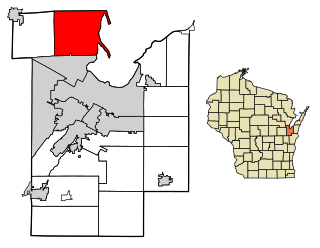
Howard is a village in Brown and Outagamie counties in the U.S. state of Wisconsin. The population was 19,950 at the 2020 census. It is part of the Green Bay Metropolitan Statistical Area.
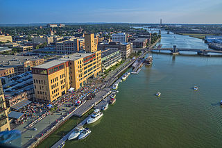
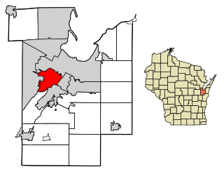
Green Bay is a city in the U.S. state of Wisconsin. The county seat of Brown County, it is at the head of Green Bay, a sub-basin of Lake Michigan at the mouth of the Fox River. As of the 2020 Census, Green Bay had a population of 107,395, making it the third-most populous city in Wisconsin, after Milwaukee and Madison, and the third-largest city on Lake Michigan, after Chicago and Milwaukee.

Luxemburg is a village in Kewaunee County, Wisconsin, United States. The population was 2,515 at the 2010 census. It is part of the Green Bay Metropolitan Statistical Area. The village is located within the town of Luxemburg.

Sturgeon Bay is a city in and the county seat of Door County, Wisconsin, United States. The population was 9,646 at the 2020 Census. The city is well-known regionally for being the largest city of the Door Peninsula, after which the county is named.

US Highway 141 (US 141) is a north–south United States Numbered Highway in the states of Wisconsin and Michigan. The highway runs north-northwesterly from an interchange with Interstate 43 (I-43) in Bellevue, Wisconsin, near Green Bay, to a junction with US 41/M-28 near Covington, Michigan. In between, it follows city streets in Green Bay and has a concurrent section with US 41 in Wisconsin. North of Green Bay, US 141 is either a freeway or an expressway into rural northern Wisconsin before downgrading to an undivided highway. In Michigan, US 141 is an undivided highway that runs through rural woodlands. The highway has two segments in each state; after running through Wisconsin for about 103 miles (166 km), it crosses into Michigan for approximately another eight miles (13 km). After that, it crosses back into Wisconsin for about 14+1⁄2 miles (23 km) before crossing the state line one last time. The northernmost Michigan section is about 43+1⁄2 miles (70 km), making the overall length about 169 miles (272 km).

Ellison Bay is an unincorporated community and census-designated place in northern Door County, Wisconsin, United States, within the town of Liberty Grove and is located on Highway 42 along the Green Bay. As of the 2020 census, its population is 249. Sur La Baie, one of Wisconsin's largest and most expensive homes, is located nearby.

Wisconsin Highway 57 is a 191.82-mile-long (308.70 km) state highway in Wisconsin, United States. It runs from its southern terminus at WIS 59 in Milwaukee to its northern terminus at WIS 42 in Sister Bay. Much of WIS 57 parallels Interstate 43 (I-43) and WIS 42, particularly from Saukville to its northern terminus in Sister Bay. The highway runs concurrently with I-43 for 12 miles (19 km) in Ozaukee County. Like most Wisconsin state highways, WIS 57 is maintained by the Wisconsin Department of Transportation (WisDOT).

U.S. Highway 41 (US 41) is a north–south highway United States Numbered Highway in eastern Wisconsin. It runs from Pleasant Prairie on the Illinois border north to Marinette on the Michigan border. Most of the route is concurrent with Interstate 41 in the state, with the exception of the portion between Howard, a suburb of Green Bay, and Marinette.

Greenleaf is an unincorporated census-designated place in Brown County, Wisconsin, United States, in the town of Wrightstown.
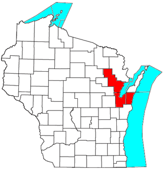
The Green Bay metropolitan statistical area, as defined by the United States Census Bureau, is a metropolitan area in northeastern Wisconsin anchored by the City of Green Bay. It is Wisconsin's fourth largest metropolitan statistical area by population. As of the 2020 Census, the MSA had a combined population of 328,268.
Sturgeon Bay is a city in the U.S. state of Wisconsin.


