The Appalachian Mountains, often called the Appalachians, are a mountain range in eastern to northeastern North America. The term "Appalachian" refers to several different regions associated with the mountain range, and its surrounding terrain. The general definition used is one followed by the United States Geological Survey and the Geological Survey of Canada to describe the respective countries' physiographic regions. The U.S. uses the term Appalachian Highlands and Canada uses the term Appalachian Uplands; the Appalachian Mountains are not synonymous with the Appalachian Plateau, which is one of the provinces of the Appalachian Highlands.

The Continental Divide of the Americas is the principal, and largely mountainous, hydrological divide of the Americas. The Continental Divide extends from the Bering Strait to the Strait of Magellan, and separates the watersheds that drain into the Pacific Ocean from those river systems that drain into the Atlantic and Arctic Ocean, including those that drain into the Gulf of Mexico, the Caribbean Sea, and Hudson Bay.

A drainage basin is an area of land where all flowing surface water converges to a single point, such as a river mouth, or flows into another body of water, such as a lake or ocean. A basin is separated from adjacent basins by a perimeter, the drainage divide, made up of a succession of elevated features, such as ridges and hills. A basin may consist of smaller basins that merge at river confluences, forming a hierarchical pattern.
The Atlantic seaboard watershed is a watershed of the Atlantic Ocean in eastern North America along the Atlantic Canada (Maritimes) coast south of the Gulf of Saint Lawrence Watershed, and the East Coast of the United States north of the Kissimmee River watershed of Lake Okeechobee basin in the central Florida Peninsula.

The Allegheny Mountain Range, informally the Alleghenies, is part of the vast Appalachian Mountain Range of the Eastern United States and Canada and posed a significant barrier to land travel in less developed eras. The Allegheny Mountains have a northeast–southwest orientation, running for about 300 miles (480 km) from north-central Pennsylvania, southward through western Maryland and eastern West Virginia.

The Allegheny Plateau is a large dissected plateau area of the Appalachian Mountains in western and central New York, northern and western Pennsylvania, northern and western West Virginia, and eastern Ohio. It is divided into the unglaciated Allegheny Plateau and the glaciated Allegheny Plateau.

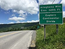
The Allegheny Front is the major southeast- or east-facing escarpment in the Allegheny Mountains in southern Pennsylvania, western Maryland, eastern West Virginia, and western Virginia. The Allegheny Front forms the boundary between the Ridge-and-Valley Appalachians to its east and the Appalachian Plateau to its west. The Front is closely associated with the Appalachian Mountains' Eastern Continental Divide, which in this area divides the waters of the Ohio/Mississippi river system, flowing to the Gulf of Mexico, from rivers flowing into Chesapeake Bay and from there into the Atlantic Ocean.
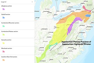
The Appalachian Plateau is a series of rugged dissected plateaus located on the western side of the Appalachian Mountains. The Appalachian Mountains are a range that run from Nova Scotia in Canada to Alabama in the United States.

A drainage divide, water divide, ridgeline, watershed, water parting or height of land is elevated terrain that separates neighboring drainage basins. On rugged land, the divide lies along topographical ridges, and may be in the form of a single range of hills or mountains, known as a dividing range. On flat terrain, especially where the ground is marshy, the divide may be difficult to discern.

The geography of Pennsylvania varies from sea level marine estuary to mountainous plateau. The state is known for its natural resources, ports, and the leading role it played in the nation's founding and history.

The Tennessee Valley Divide is the boundary of the drainage basin of the Tennessee River and its tributaries.

The geography of New York (state) varies widely. Most of New York is dominated by farms, forests, rivers, mountains, and lakes. New York's Adirondack Park is larger than any U.S. National Park in the contiguous United States. Niagara Falls, on the Niagara River as it flows from Lake Erie to Lake Ontario, is a popular attraction. The Hudson River begins near Lake Tear of the Clouds and flows south through the eastern part of the state without draining lakes George or Champlain. Lake George empties at its north end into Lake Champlain, whose northern end extends into Canada, where it drains into the Richelieu River and then the St. Lawrence. Four of New York City's five boroughs are on the three islands at the mouth of the Hudson River: Manhattan Island, Staten Island, and Brooklyn and Queens on Long Island.

A continental divide is a drainage divide on a continent such that the drainage basin on one side of the divide feeds into one ocean or sea, and the basin on the other side either feeds into a different ocean or sea, or else is endorheic, not connected to the open sea. Every continent on earth except Antarctica has at least one continental drainage divide; islands, even small ones like Killiniq Island on the Labrador Sea in Canada, may also host part of a continental divide or have their own island-spanning divide. The endpoints of a continental divide may be coastlines of gulfs, seas or oceans, the boundary of an endorheic basin, or another continental divide. One case, the Great Basin Divide, is a closed loop around an endorheic basin. The endpoints where a continental divide meets the coast are not always definite since the exact border between adjacent bodies of water is usually not clearly defined. The International Hydrographic Organization's publication Limits of Oceans and Seas defines exact boundaries of oceans, but it is not universally recognized. Where a continental divide meets an endorheic basin, such as the Great Divide Basin of Wyoming, the continental divide splits and encircles the basin. Where two divides intersect, they form a triple divide, or a tripoint, a junction where three watersheds meet.
Mountain Lake Wilderness is a U.S. Wilderness Area in the George Washington and Jefferson National Forests. The wilderness area is located next to privately owned Mountain Lake, and consists of 8,314 acres (3,365 ha) in Virginia and 2,721 acres (1,101 ha) in West Virginia.
Watersheds of North America are large drainage basins which drain to separate oceans, seas, gulfs, or endorheic basins. There are six generally recognized hydrological continental divides which divide the continent into seven principal drainage basins spanning three oceans and one endorheic basin. The basins are the Atlantic Seaboard basin, the Gulf of Mexico basin, the Great Lakes-St. Lawrence basin, the Pacific basin, the Arctic basin, the Hudson Bay basin, and the Great Basin. Together, the principal basins span the continent with the exception of numerous smaller endorheic basins.
A triple divide or triple watershed is a point on Earth's surface where three drainage basins meet. A triple divide results from the intersection of two drainage divides. Triple divides range from prominent mountain peaks to minor side peaks, down to simple slope changes on a ridge which are otherwise unremarkable. The elevation of a triple divide can be thousands of meters to barely above sea level. Triple divides are a common hydrographic feature of any terrain that has rivers, streams and/or lakes.

The Saint Lawrence River Divide is a continental divide in central and eastern North America that separates the Great Lakes-St. Lawrence River Basin from the southerly Atlantic Ocean watersheds. Water, including rainfall and snowfall, lakes, rivers and streams, north and west of the divide, drains into the Gulf of St. Lawrence or the Labrador Sea; water south and east of the divide drains into the Atlantic Ocean or Gulf of Mexico. The divide is one of six continental divides in North America that demarcate several watersheds that flow to different gulfs, seas or oceans.

Blair Gap, one of the gaps of the Allegheny, is a water gap along the eastern face atop the Allegheny Front escarpment. Like other gaps of the Allegheny, the slopes of Blair Gap were amenable to foot travel, pack mules, and possibly wagons allowing Amerindians, and then, after about 1778–1780 settlers, to travel west into the relatively depopulated Ohio Country decades before the railroads were born and tied the country together with steel.
The gaps of the Allegheny, meaning gaps in the Allegheny Ridge in west-central Pennsylvania, is a series of escarpment eroding water gaps along the saddle between two higher barrier ridge-lines in the eastern face atop the Allegheny Ridge or Allegheny Front escarpment. The front extends south through Western Maryland and forms much of the border between Virginia and West Virginia, in part explaining the difference in cultures between those two post-Civil War states. While not totally impenetrable to daring and energetic travelers on foot, passing the front outside of the water gaps with even sure footed mules was nearly impossible without navigating terrain where climbing was necessary on slopes even burros would find extremely difficult.