
The Himalayas, or Himalaya, is a mountain range in Asia, separating the plains of the Indian subcontinent from the Tibetan Plateau. The range has some of the Earth's highest peaks, including the highest, Mount Everest; more than 100 peaks exceeding elevations of 7,200 m (23,600 ft) above sea level lie in the Himalayas.
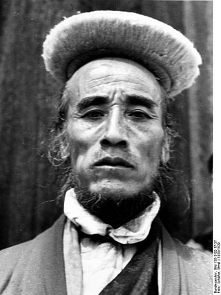
Bhotiya or Bhot is an Indian and Nepali exonym lumping together various ethnic groups speaking Tibetic languages, as well as some groups speaking other Tibeto-Burman languages living in the Transhimalayan region that divides India from Tibet. The word Bhotiya comes from the classical Tibetan name for Tibet, བོད, bod. The Bhotiya speak numerous languages including Ladakhi. The Indian recognition of such language is Bhoti / Bhotia having Tibetan scripts and it lies in the Parliament of India to become one of the official languages through Eighth Schedule of the Indian Constitution.

The Chumbi Valley, called Dromo or Tromo in Tibetan, is a valley in the Himalayas that projects southwards from the Tibetan plateau, intervening between Sikkim and Bhutan. It is coextensive with the administrative unit Yadong County in the Tibet Autonomous Region of China. The Chumbi Valley is connected to Sikkim to the southwest via the mountain passes of Nathu La and Jelep La.

The Himalayan subtropical pine forests are a large subtropical coniferous forest ecoregion covering portions of Bhutan, India, Nepal, and Pakistan.
Kyongnosla Alpine Sanctuary is a nature reserve in Gangtok district, Sikkim, India. It is situated around the area adjoining the Tsomgo (Changu) lake along the Nathula Road. Located about 31 km (19 mi) east of Gangtok, the capital of Sikkim, this sanctuary covers an area of about 31 km2 (12 sq mi), and extends from the "15th Mile" police check point up to and along the ridges bordering the Rong Chu Valley and Lake Tsomgo.

The Eastern Himalayan broadleaf forests is a temperate broadleaf forest ecoregion found in the middle elevations of the eastern Himalayas, including parts of Nepal, India, Bhutan, Myanmar and China. These forests have an outstanding richness of wildlife.

Eaglenest or Eagle's Nest Wildlife Sanctuary is a protected area of India in the Himalayan foothills of West Kameng District, Arunachal Pradesh. It conjoins Sessa Orchid Sanctuary to the northeast and Pakhui Tiger Reserve across the Kameng river to the east. Altitude ranges are extreme: from 500 metres (1,640 ft) to 3,250 metres (10,663 ft). It is a part of the Kameng Elephant Reserve.

Sessa Orchid Sanctuary is a 100 km2 protected area of India in the Himalayan foothills in Bhalukpong Forest Division of West Kameng District, Arunachal Pradesh. It conjoins Eaglenest Wildlife Sanctuary to the southwest. It is a part of the Kameng Protected Area Complex (KPAC), which is an Elephant Reserve. See map. The department of Environment & Forests has developed trekking routes for visitors to enjoy the natural habitats of orchids. There are deep gorges and valleys, high peaks and rugged terrain that are rewarding for nature lovers and adventure tourists. A nursery includes representative specimens of various orchid species of the sanctuary and a demonstration farm of Cymbidium hybrids for cut-flower production. Most of Sessa has traditionally been claimed by the Bugun tribe as part of their territory.

The Eastern Himalayan alpine shrub and meadows is a montane grasslands and shrublands ecoregion of Bhutan, China, India, Myanmar, and Nepal, which lies between the tree line and snow line in the eastern portion of the Himalaya Range.

The Northern Triangle temperate forests is a temperate broadleaf and mixed forest ecoregion of thick forest covering the mountains of northern Myanmar.

The Kingdom of Bhutan is a small, landlocked nation nestled in the southern slopes of the Eastern Himalaya. To its north lies the Tibet Autonomous Region of China and to the west, south and east lies the Indian states of Sikkim, Bengal, Assam and Arunachal Pradesh.

The Eastern Himalayan subalpine conifer forests is a temperate coniferous forests ecoregion which is found in the middle and upper elevations of the eastern Middle Himalayas, in western Nepal, Bhutan, northern Indian states including Arunachal Pradesh and Sikkim and adjacent Myanmar and China.
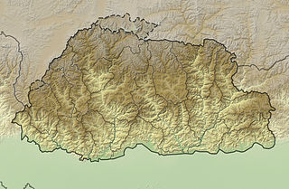
The mountains of Bhutan are some of the most prominent natural geographic features of the kingdom. Located on the southern end of the Eastern Himalaya, Bhutan has one of the most rugged mountain terrains in the world, whose elevations range from 160 metres (520 ft) to more than 7,000 metres (23,000 ft) above sea level, in some cases within distances of less than 100 kilometres (62 mi) of each other. Bhutan's highest peak, at 7,570 metres (24,840 ft) above sea level, is north-central Gangkhar Puensum, close to the border with Tibet; the third highest peak, Jomolhari, overlooking the Chumbi Valley in the west, is 7,314 metres (23,996 ft) above sea level; nineteen other peaks exceed 7,000 metres (23,000 ft). Weather is extreme in the mountains: the high peaks have perpetual snow, and the lesser mountains and hewn gorges have high winds all year round, making them barren brown wind tunnels in summer, and frozen wastelands in winter. The blizzards generated in the north each winter often drift southward into the central highlands.
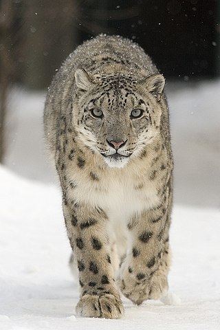
The ecology of the Himalayas varies with climate, rainfall, altitude, and soils. The climate ranges from tropical at the base of the mountains to permanent ice and snow at the highest elevations. The amount of yearly rainfall increases from west to east along the southern front of the range. This diversity of climate, altitude, rainfall and soil conditions supports a variety of distinct plant and animal species, such as the Nepal gray langur

Biogeographic classification of India is the division of India according to biogeographic characteristics. Biogeography is the study of the distribution of species (biology), organisms, and ecosystems in geographic space and through geological time. India has a rich heritage of natural diversity. India ranks fourth in Asia and tenth in the world amongst the top 17 mega-diverse countries in the world. India harbours nearly 11% of the world's floral diversity comprising over 17500 documented flowering plants, 6200 endemic species, 7500 medicinal plants and 246 globally threatened species in only 2.4% of world's land area. India is also home to four biodiversity hotspots—Andaman & Nicobar Islands, Eastern Himalaya, Indo-Burma region, and the Western Ghats. Hence the importance of biogeographical study of India's natural heritage.
The Sacred Himalayan Landscape is a 39,021 km2 (15,066 sq mi) large trans-boundary landscape in the eastern Himalayas encompassing temperate broadleaf and conifer forests, alpine meadows and grasslands, which harbour more than 80 mammal and more than 440 bird species. It extends from Nepal's Langtang National Park through Sikkim and Darjeeling in India to western Bhutan's Torsa Strict Nature Reserve. More than 73% of this landscape is located in Nepal, including Sagarmatha National Park, Makalu Barun National Park, and Kanchenjunga Conservation Area. About 24% is located in India, encompassing Khangchendzonga, Singalila and Neora Valley National Parks as well as Fambong Lho, Maenam, Senchal, Mahananda Wildlife Sanctuaries, Shingba and Barsey Rhododendron Sanctuaries and Kyongnosla Alpine Sanctuary.
Pangolakha Wildlife Sanctuary is a wildlife reserve in the Pakyong District of the state of Sikkim in India. It is about 28 kilometres (17 mi) east of Rorathang and about 40 kilometres (25 mi) by road from Rangpo city. The total notified area of the park is around 124 square kilometres (48 sq mi) while inside the wildlife sanctuary there are a few hamlets: Aritar, Dakline Lingtam, Phadamchen, Dzuluk, Gnathang Monastery Kupup. This wildlife sanctuary is linked to the forests of Neora Valley National Park of West Bengal as well as forests of Samtse, Bhutan and Haa district Bhutan. The area that comes under this biosphere has been declared in 1999 as a wildlife sanctuary under biogeographic province category 2C.

Arunachal Pradesh is primarily a hilly tract nestled in the foothills of the Himalayas in northeast India. It is spread over an area of 83,743 km2 (32,333 sq mi). 98% of the geographical area is land out of which 80% is forest cover; 2% is water. River systems in the region, including those from the higher Himalayas and Patkoi and Arakan Ranges, eventually drain into the Brahmaputra River.
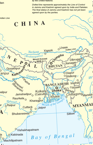
Eastern South Asia is a geographical area in the Southern Asian subregion, precisely the eastern region of the subcontinent. It includes the countries of Bangladesh, Bhutan, Nepal and India. Geographically, it lies between the Eastern Himalayas and the Bay of Bengal. Two of the world's largest rivers, the Ganges and the Brahmaputra, flow into the sea through the Bengal region. The region includes the world's highest mountainous terrain and the world's largest delta, and has a climate ranging from alpine and subalpine to subtropical and tropical. Since Nepal, Bhutan, and northeast India are landlocked, the coastlines of Bangladesh and East India serve as the principal gateways to the region.
The geology of Bhutan is less well studied than many countries in Asia, together with the broader Eastern Himalayas region. Older Paleozoic and Precambrian rocks often appear mixed together with younger sediments due to the Himalayan orogeny.

