Eckersdorf

Last updated
Eckersdorf
Eckersdorf Rathaus.jpg
Town hall
Wappen Eckersdorf.svg
Location of Eckersdorf within Bayreuth district
Eckersdorf in BT.svgPrüllWarmensteinacher Forst-NordWaidacher ForstWaidacher ForstNeubauer Forst-NordHeinersreuther ForstGlashüttener ForstForst Neustädtlein am ForstGemeindefreies Gebiet FichtelbergHaagMistelbachGlashüttenPegnitzFichtelbergBischofsgrüner ForstPottenstein
Germany adm location map.svg
Red pog.svg
Eckersdorf
Bavaria location map.svg
Red pog.svg
Eckersdorf
Coordinates: 49°55′57.97″N11°30′4.43″E / 49.9327694°N 11.5012306°E / 49.9327694; 11.5012306
Country Germany
State Bavaria
Admin. region Oberfranken
District Bayreuth
Subdivisions22 districts [1]
Government
   Mayor (202026) Sybille Pichl [2] (FW)
Area
  Total36.19 km2 (13.97 sq mi)
Elevation
416 m (1,365 ft)
Population
 (2022-12-31) [3]
  Total5,092
  Density140/km2 (360/sq mi)
Time zone UTC+01:00 (CET)
  Summer (DST) UTC+02:00 (CEST)
Postal codes
95488
Dialling codes 0921
Vehicle registration BT
Website www.eckersdorf.de

Eckersdorf is a municipality in the district of Bayreuth in Bavaria in Germany.

Contents

Geography

The municipality of Eckersdorf is located on the northern edge of an area called "Little Switzerland" (German: Fränkische Schweiz), close to the world-famous festival town of Bayreuth. The highest elevation in the region of Eckersdorf is the Sophienberg with an altitude of 593 m.

Districts

The present-day municipality of Eckersdorf was created in the course of municipal reform in 1978.

According to the information given by the local government, there are 22 official districts. [4]

DistrictPopulation
Busbach209
Donndorf2017
Eckersdorf2048
Eschen124
Forst149
Hardt22
Heisenstein4
Lahm30
Lochau22
Lohe20
Melkendorf17
Neustädtlein175
Oberwaiz350
Pleofen32
Schanz27
Simmelbuch65
Stein0
Tröbersdorf71
Vorlahm15
Waldhütte0
Windhof8
Wolfsgraben1

Neighboring communities

The neighboring communities of Eckersdorf are (starting north in clockwise order): Thurnau, Bayreuth, Mistelbach, and Mistelgau.

History

Eckersdorf was first mentioned in 1149 in the so-called Giechburgvertrag. The Counts of Andechs-Meranien (Grafen von Andechs-Meranien) owned the current area of Eckersdorf until they died off in 1248. The lords of Berg Plassenberg (Herren von Plassenberg) acquired first property in the Eckersdorf area in 1420. A hundred years later, the lords were in full possession of Eckersdorf. After the last representative of the family died in 1552, Eckersdorf came to the Lords of Lüchau, and then it fell to the Markgrafschaft Bayreuth in 1757. As part of the Prussian Principality of Bayreuth, Eckersdorf became a French possession through the Treaties of Tilsit, until 1810, when it became part of Bavaria. In the course of administrative reform in Bavaria in 1818, today's municipality Eckersdorf was created. [5]

Politics

At the latest elections for mayor in 2020, Sybille Pichl (Freie Wählergemeinschaft Eckersdorf-Donndorf und Umgebung) was re-elected. She has been in office since 2010. [2]

Sights

Schloss Fantaisie (north view) Eckersdorf-Schloss Fantaisie.JPG
Schloss Fantaisie (north view)
Oberwaiz: forester's house, former Jagdschloss of the Plassenbergers, now used by the Evangelisch Reformed church, built in 1776 Forsthaus Oberwaiz.JPG
Oberwaiz: forester's house, former Jagdschloss of the Plassenbergers, now used by the Evangelisch Reformed church, built in 1776

Johann Jacob Spindler built Schloss Fantaisie for Margravine Elisabeth Fredericka Sophie of Brandenburg-Bayreuth from 1758 to 1765. Today, there is a garden museum in this rococo palace. The listed town hall in the Donndorf district was built around 1830.

St. Agidius church was built in 1791 and the forester's house Oberwaiz in 1776. St Aegidius Eckersdorf.jpg
St. Ägidius church was built in 1791 and the forester's house Oberwaiz in 1776.

Related Research Articles

Kulmbach is a Landkreis (district) in Bavaria, Germany. It is bounded by the districts of Kronach, Hof, Bayreuth and Lichtenfels.

Lichtenfels is a Landkreis (district) in Bavaria, Germany. It is bounded by the districts of Coburg, Kronach, Kulmbach, Bayreuth and Bamberg.

<span class="mw-page-title-main">Neustadt bei Coburg</span> Town in Bavaria, Germany

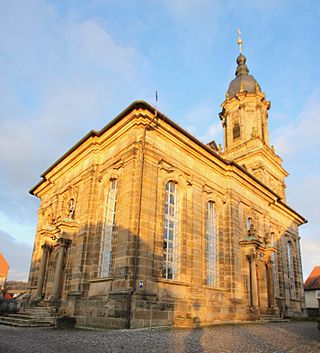
Neustadt bei Coburg is a town in the district of Coburg in northern Bavaria, Germany. It is situated 15 km northeast of Coburg, as its name indicates.

<span class="mw-page-title-main">Hirschaid</span> Municipality in Bavaria, Germany

Hirschaid is a German market town in the Upper Franconian district of Bamberg and lies roughly twelve kilometres south of Bamberg on the Regnitz and the Main-Danube Canal.

<span class="mw-page-title-main">Bad Berneck im Fichtelgebirge</span> Place in Bavaria, Germany

Bad Berneck im Fichtelgebirge is a spa town in the district of Bayreuth, in Bavaria, Germany. It is situated on the White Main river, in the Fichtel Mountains, 13 km northeast of Bayreuth. It lies in the northern part of the Bavarian province of Upper Franconia. Since 1857 it has been a spa, initially based on its climate and whey products. In 1930 it became a Kneipp spa and, in 1950, a Kneipp health spa.

<span class="mw-page-title-main">Ludwigsstadt</span> Town in Bavaria, Germany

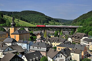
Ludwigsstadt is a town in the district of Kronach, in the Upper Franconian region of Bavaria, Germany.

<span class="mw-page-title-main">Stadelhofen</span> Municipality in Bavaria, Germany

Stadelhofen is a municipality in the Upper Franconian district of Bamberg and a member of the administrative community (Verwaltungsgemeinschaft) of Steinfeld.

<span class="mw-page-title-main">Bindlach</span> Municipality in Bavaria, Germany

Bindlach is a municipality in the district of Bayreuth in Upper Franconia in Bavaria, Germany. The town is adjacent immediately north of the town of Bayreuth. The population count of December 2006 was 7197 inhabitants.

<span class="mw-page-title-main">Markt Indersdorf</span> Municipality in Bavaria, Germany

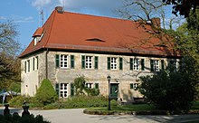
Markt Indersdorf is a municipality in the district of Dachau in Bavaria in Germany.

<span class="mw-page-title-main">Heroldsberg</span> Municipality in Bavaria, Germany

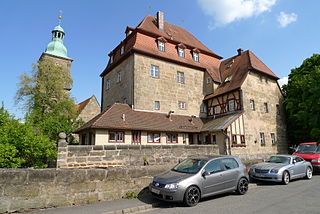
Heroldsberg is a municipality in the district of Erlangen-Höchstadt, in Bavaria, Germany. It is located eleven kilometers north-east from the city of Nuremberg and 23 kilometers east from Erlangen and is the headquarters of Schwan-Stabilo.

<span class="mw-page-title-main">Kalchreuth</span> Municipality in Bavaria, Germany

Kalchreuth is a municipality in the district of Erlangen-Höchstadt, in Bavaria, Germany. It is located 10 kilometers east of Erlangen and 15 kilometers north of Nuremberg and contains the villages of Kalchreuth, Käswasser and Röckenhof and also the hamlets of Stettenberg, Minderleinsmühle and Gabermühle.

<span class="mw-page-title-main">Pretzfeld</span> Municipality in Bavaria, Germany

Pretzfeld is a municipality in the district of Forchheim in Bavaria in Germany.

<span class="mw-page-title-main">Althegnenberg</span> Municipality in Bavaria, Germany

Althegnenberg is a municipality in the district of Fürstenfeldbruck in Bavaria in Germany. The municipality consists of the villages Althegnenberg, Hörbach and Lindenhof.

<span class="mw-page-title-main">Trogen, Bavaria</span> Municipality in Bavaria, Germany

Trogen is a municipality in Upper Franconia in the district of Hof in Bavaria in Germany.

<span class="mw-page-title-main">Dießen am Ammersee</span> Municipality in Bavaria, Germany

Dießen am Ammersee is a municipality in the district of Landsberg in Bavaria in Germany. It is located on the shores of the Ammersee.

<span class="mw-page-title-main">Kirchzell</span> Municipality in Bavaria, Germany

Kirchzell is a market community in the Miltenberg district in the Regierungsbezirk of Lower Franconia (Unterfranken) in Bavaria, Germany.

<span class="mw-page-title-main">Mallersdorf-Pfaffenberg</span> Municipality in Bavaria, Germany

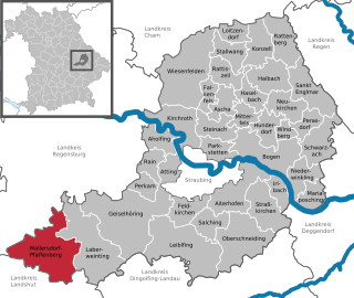
Mallersdorf-Pfaffenberg is a municipality in the district of Straubing-Bogen in Bavaria, Germany and has around 7,000 inhabitants.

<span class="mw-page-title-main">Kürnach</span> Municipality in Bavaria, Germany

Kürnach is a municipality in the district of Würzburg in Bavaria in Germany. The distance from Kürnach to the state capital of Bavaria München is about 221 km.

<span class="mw-page-title-main">Erlabrunn</span> Municipality in Bavaria, Germany

Erlabrunn is a municipality in the district of Würzburg in Bavaria, Germany, situated on the left bank of the river Main. It forms an administrative division together with its neighbour Margetshöchheim. It is known for its viticulture and its orcharding.

<span class="mw-page-title-main">Verkehrsverbund Großraum Nürnberg</span>

The Verkehrsverbund Großraum Nürnberg is the transit authority of the city of Nuremberg, the second largest city of the German state of Bavaria. Its jurisdiction covers the city and its surrounding area, responsible for the Nuremberg S-Bahn commuter trains, the Nuremberg U-Bahn, the Nuremberg tramway and buses. While not co-extensive with the wider Nuremberg Metropolitan Region, it covers most of it with the exception of several smaller towns and rural areas on the periphery, as well as Sonneberg in the neighboring state of Thuringia.

References