Fichtelberg, Bavaria

Last updated
Fichtelberg
Fichtelsee.jpg
Wappen von Fichtelberg (Oberfranken).svg
Location of Fichtelberg within Bayreuth district
Fichtelberg in BT.svgPrüllWarmensteinacher Forst-NordWaidacher ForstWaidacher ForstNeubauer Forst-NordHeinersreuther ForstGlashüttener ForstForst Neustädtlein am ForstGemeindefreies Gebiet FichtelbergHaagMistelbachGlashüttenPegnitzFichtelbergBischofsgrüner ForstPottenstein
Germany adm location map.svg
Red pog.svg
Fichtelberg
Bavaria location map.svg
Red pog.svg
Fichtelberg
Coordinates: 49°59′57.68″N11°51′4.52″E / 49.9993556°N 11.8512556°E / 49.9993556; 11.8512556
Country Germany
State Bavaria
Admin. region Oberfranken
District Bayreuth
Subdivisions3 Ortsteile
Government
   Mayor (202026) Sebastian Voit [1] (CSU)
Area
  Total5.17 km2 (2.00 sq mi)
Elevation
685 m (2,247 ft)
Population
 (2022-12-31) [2]
  Total1,818
  Density350/km2 (910/sq mi)
Time zone UTC+01:00 (CET)
  Summer (DST) UTC+02:00 (CEST)
Postal codes
95686
Dialling codes 09272
Vehicle registration BT
Website www.fichtelberg.de
Fichtelberg (postcard around 1910/1920) Fichtelberg Felle.jpg
Fichtelberg (postcard around 1910/1920)

Fichtelberg is a municipality in the district of Bayreuth in Bavaria in Germany. It is a state-recognised climatic spa (Luftkurort).

Contents

Geography

Fichtelberg lies on the southeastern slopes of the Ochsenkopf, the second highest summit of the Fichtel Mountains, and the most populous place in the Fichtel Mountain Nature Park. Fichtelberg lies on a major European watershed. Two rivers rise above the suburb of Neubau, the White Main, one of the two headstreams of the Main, which flows westwards to the Rhine, and the Fichtelnaab, which flows south and enters the Danube.

Since 1857 Fichtelberg has belonged to the Bavarian provinces of Upper Franconia.

Municipal divisions

Neighbouring parish

The only parish that borders immediately on Fichtelberg is Mehlmeisel.

Etymology

The origin of the name Fichtelberg, as well as the Fichtel Mountains is probably to be found in mining lore and not, as long suspected, its dense, spruce forests. At the time the name originated, pollen analysis shows that in the North Bavarian region mixed forests of beech, fir and spruce existed. It was only due to the mining and smelting industry, that hardwood species were decimated and faster-growing spruce was planted to supply wood for the mines. At first, only a mountain called Vythenberg where the St. Vitus mine was located, was mentioned in a charter of 1317; this later became the Ochsenkopf. The original name later evolved into the word Vichtel or Fichtel and was eventually used for the entire terrain of present-day Fichtel Mountains. The first written record of the Viechtlpergs dates to 1508.

History

The history of the site at Fichtelberg is dominated by ore mining of the mining company Erzgrube Gottesgab im Gleißingerfels am Fichtelberg. In 1600 the uppermost reaches of the Fichtelnaab valley near the present villages of Neubau and Fichtelberg was still covered with a rugged, forest-covered wilderness. Finds, such as a serpentine pendant in 1922 on the Ochsenkopf or a stone axe head excavated in 1935 east of Fichtelberg, suggest that the area around Fichtelberg was already inhabited in the Neolithic period, at least by hunters passing through. The absence of other finds, however, rules out any permanent settlement until the beginning of the 17th century. This was probably due to the steep slopes and significantly higher altitude along with a harsh climate and less fertile soils. Iron ore mining in the upper Fichtelnaab valley began in 1478, but only a small settlement of a few houses extended from the south up to the outskirts of what is now Fichtelberg today.

In 1602, Johann Glaser founded a company of six influential and financially powerful men, in order to work with them to begin mining on Gleißingerfels (about halfway between the modern villages of Hütten und Neubau), to search for suitable iron ore lodes, smelt them in blast furnaces using the most modern and profitable methods of the day and to process them profitably. The wood that was needed in large quantities in the furnaces, forges, hammers and foundries, was available in the extensive forests of the region. There was also enough water at first for the water wheels of the ironworks; when eventually the available water finally became insufficient, they promptly drove channels from the highest headstreams of the Main and the Steinach, and diverted the water. One example was the Bocksgraben. A thriving iron industry rapidly developed. Iron ore was processed in the royal foundry. At first, the mines were open cast, because the ore veins were on the surface. But eventually these pits collected too much water and there were no powerful pumps at hand. So adits were driven to enable the water to drain out. These hand-hewn tunnels were so big, that a large man could easily walk through them.

The mine on the Gleißinger Fels was called Gottesgab am Fichtelberg as was the important mining office established later far up the Fichtelnaab valley. The first accommodation huts appeared, the beginnings of a now growing and thriving mining settlement, and four furnaces smelted the silver iron that was mined in the Fichtelberg area. At this time, the region around Fichtelberg was the most important mining operation in the Electorate of Bavaria. Fichtelberg came under the Amberg Rentamt  [ bar; de; es ] and the Waldeck district court (Landgericht) in the Electorate of Bavaria. The mining office had the legal status of a royal estate (Hofmark). In 1808 the Fichtelberg Mining Office, as a border region, changed hand repeatedly between the Kingdom of Bavaria and Margrave of Bayreuth. Since 1857, when the district of the then Bayreuth District Court was enlarged, it has been part of the province of Upper Franconia. Ore mining and smelting had been the economic factor in Fichtelberg, but with the beginning of industrialization, ore mining became less and less profitable. On 26 March 1859 work ceased and, in 1862, the mining company closed. It was initially followed by an economic decline which could only be partially compensated for by quarrying of granite and 'greenstone' (Proterobas), which had already since been worked on the Ochsenkopf massif since the beginning of the 17th century - and which was used especially for glass production - and by the timber industry. Many residents left the area.

After the Second World War, settlers came, mainly glass blowers from Gablonz, and helped Fichtelberg to renewed prosperity as an industrial site based on the glass and button production.

Since then it has largely lost its industrial importance, but survives because of its scenic location on the southwestern slope of the Ochsenkopf, mainly from tourism, and its function as a winter sports centre.

The Gleißinger Fels mines are the oldest in northern Bavaria and are the only silver iron (Silbereisen) mine in the world, which is still accessible to the public.

Tourism

view from south on lake Fichtelsee, close to campsite Blick uber den Fichtelsee (von Suden).jpg
view from south on lake Fichtelsee, close to campsite

Government

Parish council

The council has 14 members:

(as at local elections in 2014)

Mayor

The mayor (Bürgermeister) is Sebastian Voit (CSU), elected in 2020.

Culture and points of interest

Mariensaule Fichtelberg.jpg
Column with 4 putti
Mariensaule Fichtelberg Muttergottes auf der Weltkugel.jpg
Marian sculpture
Baroque Marian column with 4 putti

Sport

Sport

Museums

Transport

Fichtelberg lies about 3 kilometres south of the B 303 and not far from the A 9 motorway from Berlin-Nuremberg, exit Bad Berneck or, from Berlin, Gefrees,

Related Research Articles

<span class="mw-page-title-main">Ore Mountains</span> Mountain range in Central Europe

The Ore Mountains lie along the Czech–German border, separating the historical regions of Bohemia in the Czech Republic and Saxony in Germany. The highest peaks are the Klínovec in the Czech Republic at 1,244 metres (4,081 ft) above sea level and the Fichtelberg in Germany at 1,215 metres (3,986 ft).

<span class="mw-page-title-main">Fichtel Mountains</span> Mountain range in Germany

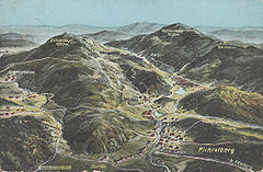
The Fichtel Mountains is a mountain range in Germany and the Czech Republic. They extend from the valley of the Red Main River in northeastern Bavaria to the Karlovy Vary Region in western Czech Republic. The Fichtel Mountains contain an important nature park, the Fichtel Mountain Nature Park. The Elster Mountains are a part of the Fichtel Mountains.

<span class="mw-page-title-main">White Main</span> River in Germany

The White Main, is the larger and shorter of the two headstreams of the river Main. It rises in the Fichtel Mountains and merges near Steinenhausen, southwest of Kulmbach, with the left-hand, southern headstream, the Red Main, to form the Main. The length of the White Main is 51.7 km. The source of the White Main lies on light granite rock, which lends it its white colouration.

<span class="mw-page-title-main">Hammer mill</span> Pre-industrial workshop utilizing water-driven trip hammers

A hammer mill, hammer forge or hammer works was a workshop in the pre-industrial era that was typically used to manufacture semi-finished, wrought iron products or, sometimes, finished agricultural or mining tools, or military weapons. The feature that gave its name to these workshops was the water-driven trip hammer, or set of hammers, used in the process. The shaft, or 'helve', of the hammer was pivoted in the middle and the hammer head was lifted by the action of cams set on a rotating camshaft that periodically depressed the end of the shaft. As it rose and fell, the head of the hammer described an arc. The face of the hammer was made of iron for durability.

<span class="mw-page-title-main">Bad Berneck im Fichtelgebirge</span> Place in Bavaria, Germany

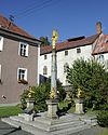
Bad Berneck im Fichtelgebirge is a spa town in the district of Bayreuth, in Bavaria, Germany. It is situated on the White Main river, in the Fichtel Mountains, 13 km northeast of Bayreuth. It lies in the northern part of the Bavarian province of Upper Franconia. Since 1857 it has been a spa, initially based on its climate and whey products. In 1930 it became a Kneipp spa and, in 1950, a Kneipp health spa.

<span class="mw-page-title-main">Red Main</span> River in Germany

The Red Main is a river in southern Germany. It is the southern, left headstream of the river Main. It rises in the hills of Franconian Switzerland, near Haag and flows generally northwest through the towns Creußen, Bayreuth, Heinersreuth and Neudrossenfeld. It merges with the White Main near Kulmbach to form the Main. The Red Main is 72 kilometres (45 mi) long and descends a total of 283 metres (928 ft).

The Neusorg–Fichtelberg railway was a German branch line northern Bavaria. It linked the town of Fichtelberg in the Upper Franconian county of Bayreuth with Neusorg station in the Upper Palatine county of Tirschenreuth on the main line from Nuremberg to Cheb. This standard gauge, single-track Lokalbahn was 14.7 km long and was opened on 20 December 1890 by the Royal Bavarian State Railways.

<span class="mw-page-title-main">Fichtel Mountain Nature Park</span>

The Fichtel Mountain Nature Park lies in the tri-border area of Saxony, the Czech Republic and Bavaria and has an area of 1,020 km2 (390 sq mi). It is maintained by the Naturpark Fichtelgebirge e. V. in Wunsiedel.

The Kohlberg is a forested mountain made of quartz phyllite in northeast Bavaria, south of Arzberg. Its summit is 632 m above sea level (NN) high and it is one of the highest mountains in the Fichtel Mountains.

<span class="mw-page-title-main">Ochsenkopf (Fichtel Mountains)</span>

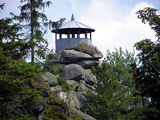
The Ochsenkopf is the second-highest mountain in the Fichtel Mountains with a height of 1,024 metres (3,360 ft). On its summit is an observation tower and a transmission tower for VHF and TV programmes by Bayerischer Rundfunk.

<span class="mw-page-title-main">Fichtelnaab</span> River in Germany

The Fichtelnaab is a river, 47.5 kilometres long, in Upper Franconia and the Upper Palatinate, Bavaria, Germany. It rises in the Fichtel Mountains and flows into the Waldnaab near Windischeschenbach.

<span class="mw-page-title-main">Fichtelgebirge Club</span> Hiking club

The Fichtelgebirge Club is a large walking club and local heritage society in Bavaria and recognised conservation group with 20,000 members in 55 local groups. As the name says, its main sphere of activity is in the Fichtel Mountains in north Bavaria. Its emblem is the Arctic starflower.

<span class="mw-page-title-main">Kösseine</span>

The Kösseine is a massif in the High Fichtel mountains in Germany, lying in northeast Bavaria south of Wunsiedel. The highest elevation of this granite massif is the summit of the Große Kösseine, 939 m above sea level (NN). The border between the Bavarian provinces of Upper Franconia and Upper Palatinate runs over the Kösseine as does the European watershed between the North Sea and the Black Sea. Around the Kösseine are the settlements of Wunsiedel, Marktredwitz, Bad Alexandersbad, Waldershof, Hohenhard, Neusorg, Brand, Ebnath, Nagel and Tröstau, tourist resorts within the Fichtel Mountains.

<span class="mw-page-title-main">Steinwald</span>

The Steinwald is a mountain range up to 946 m above sea level (NN) in southern Germany and, at the same time, a nature park founded in 1970 with an area of 246 square kilometres (95 sq mi) in the province of Upper Palatinate, in North Bavaria.

<span class="mw-page-title-main">Ölschnitz (White Main)</span> River in Germany

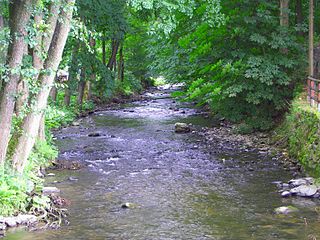
The Ölschnitz is a right-bank, northern headstream of the White Main in the German province of Upper Franconia in Bavaria. It is 22.1 kilometres (13.7 mi) long.

<span class="mw-page-title-main">Großer Waldstein</span>

The Großer Waldstein is part of the Waldstein range in the Fichtel Mountains of Germany. It is known primarily for its rock formations caused by spheroidal weathering, its ruined castles and the only remaining bear trap (Bärenfang) in the region.

<span class="mw-page-title-main">Erzberg mine</span>

The Erzberg mine is a large open-pit mine located in Eisenerz, Styria, in the central-western part of Austria, 60 km north-west of Graz and 260 km south-west of the capital, Vienna. The deposit lies at the Northern fringes of the Eastern greywacke zone, a band of Paleozoic metamorphosed sedimentary rocks that run east-west through the Austrian Alps, rich in copper and iron ore. Erzberg is the largest iron ore reserves in Austria, having estimated reserves of 235 million tonnes of ore. The mine produces around 3.2 million tonnes of pure iron ore per year. It is also the site of the annual Erzberg Rodeo hard enduro motorbike race.

<span class="mw-page-title-main">Jean-Paul-Weg</span>

The Jean-Paul-Weg is a 150 km hiking trail in Germany in honour of the writer Jean Paul Friedrich Richter (1763–1825), leading through the Franconian Forest, Fichtel Mountains, and Little Switzerland.

<span class="mw-page-title-main">Burgstall Schlosshügel</span>

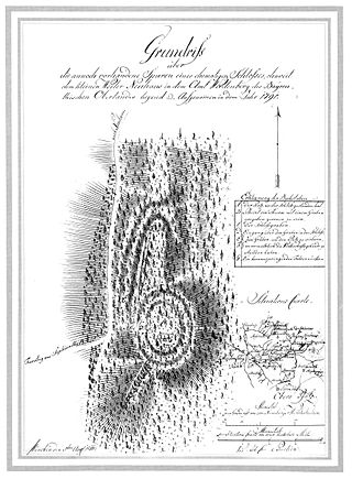
The Burgstall of Schlosshügel near Weidenberg is a lost hill castle or circular rampart site of the type known as a motte from the Early Middle Ages. It lies on the southern perimeter of the Fichtel Mountains at a height of 699 metres above sea level (NN) above the village of Sophienthal, which is part of the market borough of Weidenberg in the Upper Franconia county of Bayreuth in Bavaria. The burgstall or lost castle site was partly investigated by means of an archaeological test excavation and was also mapped several times in the past.

<span class="mw-page-title-main">Adolphus William Copper Smelter</span> Historic site in Queensland, Australia

Adolphus William Copper Smelter is a heritage-listed former copper smelter and associated mining camp at Westwood and Oakey Creek in Rockhampton Region, Queensland, Australia. It was built in 1874. It was added to the Queensland Heritage Register on 13 May 2011.

References

Further reading

Dietmar Herrmann: Der Ochsenkopf im Fichtelgebirge, Heft 17/2009 der Schriftenreihe des Fichtelgebirgsvereins e.V.