Hurricane Alicia was a small but powerful tropical cyclone that caused significant destruction in the Greater Houston area of Southeast Texas in August 1983. Although Alicia was a relatively small hurricane, its track over the rapidly growing metropolitan area contributed to its $3 billion damage toll, making it the costliest Atlantic hurricane at the time. Alicia spawned from a disturbance that originated from the tail-end of a cold front over the northern Gulf of Mexico in mid-August 1983. The cyclone was named on August 14 when it became a tropical storm, and the combination of weak steering currents and a conducive environment allowed Alicia to quickly intensify as it drifted slowly westward. On August 17, Alicia became a hurricane and continued to strengthen, topping out as a Category 3 major hurricane as it made landfall on the southwestern end of Galveston Island. Alicia's eye passed just west of Downtown Houston as the system accelerated northwestwards across East Texas; Alicia eventually weakened into a remnant area of low pressure over Oklahoma on August 20 before they were last noted on August 21 over eastern Nebraska.

The 2004 Atlantic hurricane season was a very deadly, destructive, and active Atlantic hurricane season, with over 3,200 deaths and more than $61 billion in damage. More than half of the 16 tropical cyclones brushed or struck the United States. Due to the development of a Modoki El Niño – a rare type of El Niño in which unfavorable conditions are produced over the eastern Pacific instead of the Atlantic basin due to warmer sea surface temperatures farther west along the equatorial Pacific – activity was above average. The season officially began on June 1 and ended on November 30, though the season's last storm, Otto, dissipated on December 3, extending the season beyond its traditional boundaries. The first storm, Alex, developed offshore of the Southeastern United States on July 31, one of the latest dates on record to see the formation of the first system in an Atlantic hurricane season. It brushed the Carolinas and the Mid-Atlantic, causing one death and $7.5 million (2004 USD) in damage. Several storms caused only minor damage, including tropical storms Bonnie, Earl, Hermine, and Matthew. In addition, hurricanes Danielle, Karl, and Lisa, Tropical Depression Ten, Subtropical Storm Nicole and Tropical Storm Otto had no effect on land while tropical cyclones. The season was the first to exceed 200 units in accumulated cyclone energy (ACE) since 1995, mostly from Hurricane Ivan, the storm produced the highest ACE. Ivan generated the second-highest ACE in the Atlantic, only behind 1899 San Ciriaco Hurricane.

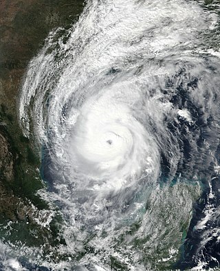
Hurricane Ivan was a large, long-lived, Cape Verde hurricane that caused widespread damage in the Caribbean and United States. The cyclone was the ninth named storm, the sixth hurricane and the fourth major hurricane of the active 2004 Atlantic hurricane season.

Hurricane Ethel was one of two major hurricanes in the 1960 Atlantic hurricane season. The sixth known tropical cyclone, fifth named storm, and fourth hurricane of the season, Ethel developed from a disturbance in the Gulf of Mexico on September 14. After becoming a tropical storm, Ethel rapidly intensified and became a hurricane six hours later. By early on September 15, the storm reached major hurricane intensity when it became a Category 3 hurricane on the Saffir–Simpson hurricane scale. However, shortly thereafter, Ethel rapidly weakened back to a Category 1 hurricane while brushing eastern Louisiana. Later on September 15, Ethel weakened to a tropical storm. Early on the following day, Ethel made landfall in Pascagoula, Mississippi. The storm gradually weakened inland, before eventually dissipating over southern Kentucky on September 17.
Hurricane Katrina's winds and storm surge reached the Mississippi coastline on the morning of August 29, 2005. beginning a two-day path of destruction through central Mississippi; by 10 a.m. CDT on August 29, 2005, the eye of Katrina began traveling up the entire state, only slowing from hurricane-force winds at Meridian near 7 p.m. and entering Tennessee as a tropical storm. Many coastal towns of Mississippi had already been obliterated, in a single night. Hurricane-force winds reached coastal Mississippi by 2 a.m. and lasted over 17 hours, spawning 11 tornadoes and a 28-foot (8.5 m) storm surge flooding 6–12 miles (9.7–19.3 km) inland. Many, unable to evacuate, survived by climbing to attics or rooftops, or swimming to higher buildings and trees. The worst property damage from Katrina occurred in coastal Mississippi, where all towns flooded over 90% in hours, and waves destroyed many historic buildings, with others gutted to the 3rd story. Afterward, 238 people died in Mississippi, and all counties in Mississippi were declared disaster areas, 49 for full federal assistance. Regulations were changed later for emergency centers and casinos. The emergency command centers were moved higher because all 3 coastal centers flooded at 30 ft (9.1 m) above sea level. Casinos were allowed on land rather than limited to floating casino barges as in 2005.

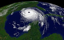
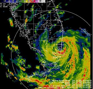
Hurricane Rita was the most intense tropical cyclone on record in the Gulf of Mexico and the fourth-most intense Atlantic hurricane ever recorded. Part of the record-breaking 2005 Atlantic hurricane season, which included three of the top ten most intense Atlantic hurricanes in terms of barometric pressure ever recorded, Rita was the seventeenth named storm, tenth hurricane, and fifth major hurricane of the 2005 season. It was also the earliest-forming 17th named storm in the Atlantic until Tropical Storm Rene in 2020. Rita formed near The Bahamas from a tropical wave on September 18, 2005 that originally developed off the coast of West Africa. It moved westward, and after passing through the Florida Straits, Rita entered an environment of abnormally warm waters. Moving west-northwest, it rapidly intensified to reach peak winds of 180 mph (285 km/h), achieving Category 5 status on September 21. However, it weakened to a Category 3 hurricane before making landfall in Johnson's Bayou, Louisiana, between Sabine Pass, Texas and Holly Beach, Louisiana, with winds of 115 mph (185 km/h). Rapidly weakening over land, Rita degenerated into a large low-pressure area over the lower Mississippi Valley by September 26th.

The 2005 Atlantic hurricane season was an event in the annual tropical cyclone season in the north Atlantic Ocean. It was the second most active Atlantic hurricane season in recorded history, and the most extreme in the satellite era. Officially, the season began on June 1, 2005 and ended on November 30, 2005. These dates, adopted by convention, historically delimit the period in each year when most tropical systems form. The season's first storm, Tropical Storm Arlene, developed on June 8. The final storm, Tropical Storm Zeta, formed in late December and persisted until January 6, 2006. Zeta is only the second December Atlantic storm in recorded history to survive into January, joining Hurricane Alice in 1955.

Hurricane Danny was the only hurricane to make landfall in the United States during the 1997 Atlantic hurricane season, and the second hurricane and fourth tropical storm of the season. The system became the earliest-formed fifth tropical or subtropical storm of the Atlantic season in history when it attained tropical storm strength on July 17, and held that record until the 2005 Atlantic hurricane season when Tropical Storm Emily broke that record by several days. Like the previous four tropical or subtropical cyclones of the season, Danny had a non-tropical origin, after a trough spawned convection that entered the warm waters of the Gulf of Mexico. Danny was guided northeast through the Gulf of Mexico by two high pressure areas, a rare occurrence in the middle of July. After making landfall on the Gulf Coast, Danny tracked across the southeastern United States and ultimately affected parts of New England with rain and wind.
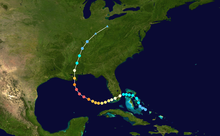
The meteorological history of Hurricane Ivan, the longest tracked tropical cyclone of the 2004 Atlantic hurricane season, lasted from late August through late September. The hurricane developed from a tropical wave that moved off the coast of Africa on August 31. Tracking westward due to a ridge, favorable conditions allowed it to develop into Tropical Depression Nine on September 2 in the deep tropical Atlantic Ocean. The cyclone gradually intensified until September 5, when it underwent rapid deepening and reached Category 4 status on the Saffir-Simpson Hurricane Scale; at the time Ivan was the southernmost major North Atlantic hurricane on record.

The effects of Hurricane Ivan in Florida in mid-to-late September 2004 were quite destructive, with over 14 direct deaths being caused by the storm, and at least $113 million in damage. After Ivan was a Category 5 at three separate points, the storm weakened to a Category 3 before making landfall in nearby Alabama. However, neighboring Florida still saw destructive impacts from Ivan.
The effects of Hurricane Katrina in Florida were in both the southern portion of the state and in the panhandle. After developing on August 23, Katrina made landfall near the border of Broward and Miami-Dade counties with 80 mph (130 km/h) winds on August 25. While it was crossing the state, the hurricane's convection was asymmetrical, primarily located to the south and east of the center. As a result, high rainfall totals occurred in the Miami area, peaking at 16.43 in (417 mm) in Perrine. The rains caused flooding, and the combination of rains and winds downed trees and power lines, leaving 1.45 million people without power. Damage in South Florida was estimated at $523 million (2005 USD), mostly as a result of crop damage. Further south, the hurricane spawned a tornado in the Florida Keys. In the island chain, Katrina caused heavy rainfall and gusty winds.

The 1932 Florida–Alabama hurricane was a tropical cyclone that made two separate landfalls on the United States, causing devastation in affected areas. The third named storm and hurricane of the 1932 Atlantic hurricane season, it developed from a tropical disturbance north of Hispaniola on August 26. Slowly moving towards the west-northwest, the system intensified to tropical storm strength before making landfall on South Florida early on August 30. After crossing the Florida peninsula and entering the Gulf of Mexico, the system reached peak intensity as a Category 1 hurricane, before subsequently making its final landfall near the Mississippi–Alabama border on September 1. Over land, the hurricane weakened, and after becoming an extratropical cyclone on September 2, merged with another extratropical system over Quebec on September 4.

The 2020 Atlantic hurricane season was the most active Atlantic hurricane season on record, in terms of number of systems. It featured a total of 31 tropical or subtropical cyclones, with all but one cyclone becoming a named storm. Of the 30 named storms, 14 developed into hurricanes, and a record-tying seven further intensified into major hurricanes. It was the second and final season to use the Greek letter storm naming system, the first being 2005, the previous record. Of the 30 named storms, 11 of them made landfall in the contiguous United States, breaking the record of nine set in 1916. During the season, 27 tropical storms established a new record for earliest formation date by storm number. This season also featured a record ten tropical cyclones that underwent rapid intensification, tying it with 1995, as well as tying the record for most Category 4 hurricanes in a singular season in the Atlantic Basin. This unprecedented activity was fueled by a La Niña that developed in the summer months of 2020, continuing a stretch of above-average seasonal activity that began in 2016. Despite the record-high activity, this was the first season since 2015 in which no Category 5 hurricanes formed.

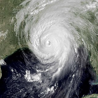
Hurricane Sally was a destructive and slow-moving Atlantic hurricane that was the first hurricane to make landfall in the U.S. state of Alabama since Ivan in 2004, coincidentally on the same date in the same place. The eighteenth named storm and seventh hurricane of the extremely active 2020 Atlantic hurricane season, Sally developed from an area of disturbed weather which was first monitored over the Bahamas on September 10. The system grew a broad area of low-pressure on September 11, and was designated as a tropical depression late that day. Early the next day, the depression made landfall at Key Biscayne and subsequently strengthened into Tropical Storm Sally that afternoon. Moderate northwesterly shear prevented significant intensification for the first two days, but convection continued to grow towards the center and Sally slowly intensified. On September 14, a center reformation into the center of the convection occurred, and data from a hurricane hunter reconnaissance aircraft showed that Sally had rapidly intensified into a strong Category 1 hurricane. However, an increase in wind shear and upwelling of colder waters halted the intensification and Sally weakened slightly on September 15 before turning slowly northeastward. Despite this increase in wind shear, it unexpectedly re-intensified, reaching Category 2 status early on September 16 before making landfall at peak intensity at 09:45 UTC on September 16, near Gulf Shores, Alabama, with maximum sustained winds of 110 mph (180 km/h) and a minimum central pressure of 965 millibars (28.5 inHg). The storm rapidly weakened after landfall before transitioning into an extratropical low at 12:00 UTC the next day. Sally's remnants lasted for another day as they moved off the coast of the Southeastern United States before being absorbed into another extratropical storm on September 18.
Hurricane Delta was the record-tying fourth named storm of 2020 to make landfall in Louisiana, as well as the record-breaking tenth named storm to strike the United States in that year. The twenty-sixth tropical cyclone, twenty-fifth named storm, tenth hurricane, and third major hurricane of the record-breaking 2020 Atlantic hurricane season, Delta formed from a tropical wave which was first monitored by the National Hurricane Center (NHC) on October 1. Moving westward, the tropical wave began to quickly organize. A well-defined center of circulation formed with sufficiently organized deep convection on October 4, and was designated as Tropical Depression Twenty-six and soon thereafter, Tropical Storm Delta. Extremely rapid intensification ensued throughout October 5 into October 6, with Delta becoming a Category 4 hurricane within 28 hours of attaining tropical storm status. The rate of intensification was the fastest in the Atlantic basin since Hurricane Wilma in 2005. After peaking in intensity however, an unexpected increase in wind shear and dry air quickly weakened the small storm before it made landfall in Puerto Morelos, Mexico as a Category 2 hurricane with 105 mph (169 km/h) winds. It weakened some more over land before emerging into the Gulf of Mexico, where it was downgraded to a Category 1 hurricane. After that, it began to restrengthen, regaining Category 3 status late on October 8. It then turned northward and reached a secondary peak intensity of 953 mbar (28.14 inHg) and winds of 120 mph early on October 9. Delta then began to turn more north-northeastward into an area of cooler waters, higher wind shear, and dry air, causing it to weaken back to Category 2 status. Delta then made landfall at 23:00 UTC near Creole, Louisiana with winds of 100 mph (160 km/h) and a pressure of 970 mbar (29 inHg). The storm began to weaken more rapidly after landfall, becoming post-tropical just 22 hours later.

Hurricane Zeta was a late-season major hurricane in 2020 that made landfall on the Yucatán Peninsula and then in southeastern Louisiana, the latest on record to do so at such strength in the United States. Zeta was the record-tying sixth hurricane of the year to make landfall in the United States. The twenty-seventh named storm, twelfth hurricane and fifth major hurricane of the extremely active 2020 Atlantic hurricane season, Zeta formed from a broad area of low pressure that formed in the western Caribbean Sea on October 19. After battling wind shear, the quasi-stationary low organized into Tropical Depression Twenty-Eight on October 24. The system strengthened into Tropical Storm Zeta early on October 25 before becoming a hurricane the next day as it began to move northwestward. Hurricane Zeta made landfall on the Yucatán Peninsula late on October 26 and weakened while inland to a tropical storm, before moving off the northern coast of the peninsula on October 27. After weakening due to dry air entrainment, Zeta reorganized and became a hurricane again, and eventually a Category 2 hurricane, as it turned northeastward approaching the United States Gulf Coast on October 28. It continued to strengthen until it reached its peak intensity as a major Category 3 hurricane with 115-mile-per-hour (185 km/h) sustained winds and a minimum pressure of 970 mbar (28.64 inHg) as it made landfall at Cocodrie, Louisiana, that evening. Zeta continued on through Mississippi and parts of Alabama with hurricane-force winds. Zeta gradually weakened as it accelerated northeastward, and became post-tropical on October 29, as it moved through central Virginia, dissipating shortly afterwards off the coast of New Jersey. After bringing accumulating snow to parts of New England, the extratropical low-pressure system carrying Zeta's remnant energy impacted the United Kingdom on November 1 and 2.

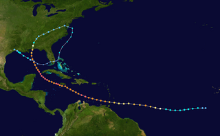
Hurricane Katrina was a devastating tropical cyclone that had a long and complex meteorological history, spanning a month from August 8 to September 7, 2005. Katrina's origins can be traced to the mid-level remnants of Tropical Depression Ten, a tropical wave, and an upper tropospheric trough. The tropical depression emerged as a wave off West Africa on August 8, the second wave followed on August 11, while the trough factored into tropical cyclogenesis between August 17 and 23. The mid-level remnants of Tropical Depression Ten merged with the second tropical wave on August 19 while located north of Hispaniola. Subsequent interaction with the trough spurred convective development, resulting in the formation of Tropical Depression Twelve over the Bahamas on August 23. Deep convection soon blossomed and following the development of banding features the system intensified into a tropical storm. As it strengthened into a hurricane, Katrina made its first landfall in the Miami Metropolitan Area on August 25.