El Pinacate y Gran Desierto de Altar Biosphere Reserve

Last updated
Reserva de la Biosfera El Pinacate
y Gran Desierto de Altar
Reserva de la Biosfera "El Pinacate".jpg
Aerial view of El Pinacate y Gran Desierto de Altar Biosphere Reserve and adjacent volcano with black lava flows
El Pinacate y Gran Desierto de Altar.png
Location of the Reserve in Mexico
Location Sonora, Mexico
Nearest city Puerto Peñasco
Plutarco Elías Calles
San Luis Río Colorado
Coordinates 32°00′N113°55′W / 32.000°N 113.917°W / 32.000; -113.917 [1]
Area2,695.05 km2 (1,040.56 sq mi) [2]
EstablishedJune 10, 1993
Governing bodyInstituto Nacional de Ecología and Tohono O'odham
elpinacate.com.mx
Official nameEl Pinacate and Gran Desierto de Altar Biosphere Reserve
TypeNatural
Criteriavii, viii, x
Designated 2013 (37th session)
Reference no. 1410
Region Latin America and the Caribbean
Official nameAgua Dulce
Designated2 February 2008
Reference no.1813 [3]
Tecolote Camp Pinacate Cholla.jpg
Pinacate volcanics with teddy-bear chollas, ocotillos, young saguaros, and a palo verde tree. Photo by Jack Dykinga.
El Pinacate.jpg
Crater Elegante

El Pinacate and Gran Desierto de Altar Biosphere Reserve (Spanish : Reserva de la Biosfera El Pinacate y Gran Desierto de Altar) is a biosphere reserve and UNESCO World Heritage Site [1] managed by the federal government of Mexico, specifically by Secretariat of the Environment and Natural Resources, in collaboration with the state governments of Sonora and the Tohono O'odham.

Contents

It is in the Sonoran Desert in northwest Mexico, east of the Gulf of California, in the eastern part of the Gran Desierto de Altar, just south of the border with Arizona, United States and north of the city of Puerto Peñasco. It is one of the most significant visible landforms in North America seen from space. A volcanic system known as Santa Clara is the main part of the landscape, including three peaks: Pinacate, Carnegie and Medio. It is a sister park to Organ Pipe Cactus National Monument in Arizona. [4] Its wildlife is threatened by the militarization of the Mexico–United States border and the construction of the Mexico–United States border wall. [5]

In the area there are over 540 species of plants, 40 species of mammals, 200 of birds, 40 of reptiles, amphibians and freshwater fishes. [6] There are threatened endemic species as Sonoran pronghorn, bighorn sheep, gila monster and desert tortoise. [7]

The biosphere reserve covers an area of 2,695.05 square kilometres (1,040.56 sq mi), [2] making up about half of the World Heritage site. The extent of the World Heritage site is 7,146 km², [8] [9] greater than that of the states of Aguascalientes, Colima, Morelos and Tlaxcala separated. [10]

Formation

El Pinacate y Gran Desierto de Altar Biosphere Reserve is known for its unique physical and biological characteristics, by the presence of a volcanic shield, and by the extensive areas of active dunes that surround it, and the greatest concentration of Maar craters. The Pinacate Mountains range has orogenic features of high interest, products of volcanic eruptions that accumulated lava in compact rocks, sand and volcanic ashes that formed colors of special beauty, and craters such as El Elegante, Cerro Colorado, MacDougal, and Sykes. [11]

The Pinacate Peaks (Picos del Pinacate), a group of volcanic peaks and cinder cones, are located in the Reserve north of Puerto Peñasco. The highest peak is Cerro del Pinacate (Santa Clara volcano), with an elevation of 1,190 metres (3,904 ft). Pinacate comes from Náhuatl language word pinacatl, for the Pinacate beetle, a stink beetle endemic to the Sonoran Desert.

The Pinacate Peaks volcanoes have erupted sporadically for about 4 million years. The most recent activity was about 11 000 years ago.

NASA sent astronauts to the Gran Desierto de Altar from 1965 to 1970, to train for walking on the Moon, due to the similarities of the terrain to the lunar surface.

History

Tohono O'odham woman. Photo by Edward S. Curtis, circa 1907. Luzi - Papago.jpg
Tohono O'odham woman. Photo by Edward S. Curtis, circa 1907.

Pre-Columbian era

The first inhabitants are known as San Dieguito people, they were hunter-gatherer who lived off the land, moving from the mountains to the Gulf of California looking for food. The early stages of occupation seem to have ended at the beginning of the ice age about 20000 years ago, when drought forced people to leave the mountain range. [12]

A second stage of occupation by San Dieguito people began in the late glacial period. This group returned to the mountains and lived as their ancestors had. Tinajas must have been a reliable source of water during this time. The second stage of occupation ended with the arrival of an antipyretic period 9000 years ago, which again forced the people to leave the territory. [6]

The most recent indigenous inhabitants of the Pinacate and Gran Desierto de Altar are the Pinacateño band of the Hia C-ed O'odham. Like the prehistoric San Dieguito culture, the Pinacateños roamed the Pinacate all the way to the sea in search of food, concentrating their camps near the tinajas. During these voyages, they left signs of their presence; one example of this is the network of paths that go from tinaja to tinaja, as well as the stone tools and potsherds found near these water sources. [6] [13]

Explorations

There are few records of those who were the first explorers in this area. Possibly the first European to see the mountain now known as Sierra Pinacate was the explorer Melchior Díaz on 1540. Subsequently, in 1698 the priest Eusebio Kino, founder of Mission San Xavier del Bac in southern Tucson, Arizona, visited the site and returned on several occasions, he and his group climbed to the top of El Pinacate, which was then named Santa Clara Hill. [6]

Before 1956, few scientists and explorers had been in El Pinacate y Gran Desierto de Altar, the most famous, the group MacDougal, Hornaday and Sykes who explored the western part of the mountain in 1907.

Related Research Articles

<span class="mw-page-title-main">Sonora</span> State of Mexico

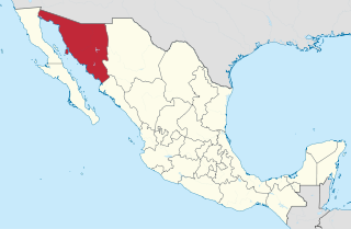
Sonora, officially Estado Libre y Soberano de Sonora, is one of the 31 states which, along with Mexico City, comprise the Federal Entities of Mexico. The state is divided into 72 municipalities; the capital city of which being Hermosillo, located in the center of the state. Other large cities include Ciudad Obregón, Nogales, San Luis Río Colorado, and Navojoa.

<span class="mw-page-title-main">Sonoran Desert</span> Desert in northwestern Mexico and the southwestern United States

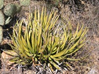
The Sonoran Desert is a hot desert in North America and ecoregion that covers the northwestern Mexican states of Sonora, Baja California, and Baja California Sur, as well as part of the southwestern United States. It is the hottest desert in both Mexico and the United States. It has an area of 260,000 square kilometers (100,000 sq mi).

<span class="mw-page-title-main">Puerto Peñasco</span> City in Sonora, Mexico

Puerto Peñasco is a small city located in Puerto Peñasco Municipality in the northwest of the Mexican state of Sonora, 100 kilometres (62 mi) from the border with the U.S. state of Arizona. According to the 2020 census, it has a population of 62,689 inhabitants. It is located on the northern shores of the Sea of Cortez on the small strip of land that joins the Baja California Peninsula with the rest of Mexico. The area is part of the Altar Desert, one of the driest and hottest areas of the larger Sonoran Desert.

<span class="mw-page-title-main">Yuma Desert</span> Part of the Sonoran Desert

The Yuma Desert is a lower-elevation section of the Sonoran Desert in the southwestern United States and the northwest of Mexico. It lies in the Salton basin. The desert contains areas of sparse vegetation and has notable areas of sand dunes. With an average rainfall less than 8 inches (200 mm) each year, it is among the harshest deserts in North America. Human presence is sparse throughout, the largest city being Yuma, Arizona, on the Colorado River and the border of California.

Federal Highway 8 is a free part of the federal highways corridors in Sonora. It is connected to the roadway that transitions from the border post at Lukeville, Arizona where it connects with Arizona State Route 85, proceeds south through Puerto Peñasco with Sonoyta, Sonora, and intersects with Fed. 2. It continues through the El Pinacate and Gran Desierto de Altar Biosphere Reserve until ending at Puerto Peñasco, a length of 100 km (62 mi).

<span class="mw-page-title-main">Lechuguilla Desert</span> Landform in southwestern Arizona

The Lechuguilla Desert is a small desert located in southwestern Arizona near the U.S.-Mexico border. It is considered to be part of the Lower Colorado Valley region of the Sonoran Desert. It lies in a north–south direction between the Gila Mountains and the Cabeza Prieta Mountains, and almost entirely in the Barry M. Goldwater Air Force Range. The desert is named after the lechuguilla plant, known scientifically as Agave lecheguilla, which occurs exclusively in the Chihuahuan desert many hundreds of miles to the east. The desert is also on the north border of the Gran Desierto de Altar of Sonora, Mexico.

<span class="mw-page-title-main">Sierra de los Tuxtlas</span>

The Sierra de Los Tuxtlas are a volcanic belt and mountain range along the southeastern Veracruz Gulf coast in Eastern Mexico. The Los Tuxtlas Biosphere Reserve includes the coastal and higher elevations of the Sierra de Los Tuxtlas.

<span class="mw-page-title-main">Gran Desierto de Altar</span> Region of the Sonoran Desert

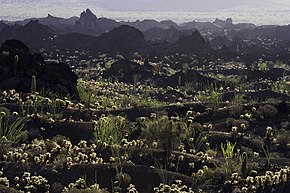
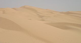
The Gran Desierto de Altar is one of the major sub-ecoregions of the Sonoran Desert, located in the State of Sonora, in northwest Mexico. It includes the only active erg dune region in North America. The desert extends across much of the northern border of the Gulf of California, spanning more than 100 kilometres (62 mi) east to west and over 50 kilometres (31 mi) north to south. It constitutes the largest continuous wilderness area within the Sonoran Desert.

The Sonoran green toad is a species of toad in the family Bufonidae. It is found in northern Mexico and the southwestern United States.

<span class="mw-page-title-main">Tinajas Altas Mountains</span> Landform in Yuma County, Arizona and Sonora, Mexico

The Tinajas Altas Mountains are an extremely arid northwest–southeast trending mountain range in southern Yuma County, Arizona, approximately 35 mi southeast of Yuma, Arizona. The southern end of the range extends approximately one mile into the northwestern Mexican state of Sonora on the northern perimeter of the Gran Desierto de Altar. The range is about 22 mi in length and about 4 mi wide at its widest point. The highpoint of the range is unnamed and is 2,766 feet above sea level and is located at 32°16'26"N, 114°02'48"W. Aside from the portion of the range in Mexico, the entirety of the range lies within the Barry M. Goldwater Air Force Range. They lie at the heart of the traditional homeland of the Hia C-eḍ O'odham people.

The Cabeza Prieta Mountains are a mountain range in the northwestern Sonoran Desert of southwest Arizona. It is located in southern Yuma County, Arizona.

Pinacate may refer to:

The Sierra Pinta or Sierra Pintas are a narrow remote block faulted northwest-southeast trending mountain range, about 22 miles (35 km) long located in southwestern Arizona in the arid northwestern Sonoran Desert, just north of the Pinacate Reserve of northern Sonora, Mexico. The mountains derive their name from visitor descriptions of its multicolored hues when viewed at sunrise and sunset.

<span class="mw-page-title-main">Pinacate Peaks</span> Group of volcanic mountains and cinder cones in Sonora, Mexico

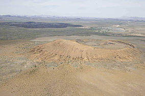
The Pinacate Peaks are a group of volcanic peaks and cinder cones located mostly in the Mexican state of Sonora along the international border adjacent to the U.S. state of Arizona, surrounded by the vast sand dune field of the Gran Desierto de Altar, at the desert's southeast.

<span class="mw-page-title-main">Puerto Peñasco Municipality</span> Municipality in Sonora, Mexico

Puerto Peñasco Municipality is a municipality in the Mexican state of Sonora in north-western Mexico. As of 2015, the municipality had a total population of 62,177 inhabitants. The only locality with a significant population is the municipal seat, also named Puerto Peñasco, which contains almost 99% of the municipality's population.

<span class="mw-page-title-main">Tinaja</span>

A tinaja is a surface pocket (depression) formed in bedrock that occurs below waterfalls, that is carved out by spring flow or seepage, or that is caused by sand and gravel scouring in intermittent streams (arroyos). Tinajas are an important source of surface water storage in arid environments.

<span class="mw-page-title-main">Alto Golfo de California Biosphere Reserve</span> UNESCO biosphere reserve in Sonora, Mexico

Alto Golfo de California Biosphere Reserve is a UNESCO Biosphere Reserve located in the state of Sonora in extreme northwestern Mexico. The 1,652,110 hectares (6,378.8 sq mi) reserve comprises the El Pinacate y Gran Desierto reserve and the Bahia Adair on the Gulf of California border. Geological volcanic formations with craters, dunes, oasis and beaches, and the diversity of plant associations determine its special landscape. The reserve was established in 1993 by the President of Mexico as Reserva de la Biosfera del Alto Golfo de California y Delta del Río Colorado and extended in 1995.

<span class="mw-page-title-main">Volcán Tacaná Biosphere Reserve</span>

The Volcán Tacaná Biosphere Reserve is a UNESCO Biosphere Reserve at the Tacaná Volcano in Chiapas, Mexico, on the border with Guatemala. The volcano is part of the Central America Volcanic Arc. The 6,378 hectares (24.63 sq mi) reserve contains fragile ecosystems very rich in wild flora and fauna species of cultural, scientific, economic and biological relevance. Its rich biodiversity and high endemism are found particularly in the high mountain ecosystem and landscapes and in the volcanic edifice which presents geophysical features of great scientific and aesthetic value. Average annual rainfall can amount to 2,000–5,000 millimetres (79–197 in), as in the case of Soconusco.

<span class="mw-page-title-main">El Elegante Crater</span> Maar in Sonora, Mexico

El Elegante is a maar located in the Gran Desierto de Altar in the Sonoran Desert, Mexico.

<span class="mw-page-title-main">Exequiel Ezcurra</span> Argentine-Mexican plant ecologist and conservationist

Exequiel Ezcurra is an Argentine-Mexican plant ecologist and conservationist. His highly interdisciplinary work spans desert plant ecology, mangroves, island biogeography, sea birds, fisheries, oceanography, and deep-sea ecosystems.

References

  1. 1 2 UNESCO. "El Pinacate and Gran Desierto de Altar Biosphere Reserve" . Retrieved June 24, 2013.
  2. 1 2 "El Pinacate y Gran Desierto de Altar Biosphere Reserve" . Retrieved 15 June 2018.
  3. "Agua Dulce". Ramsar Sites Information Service. Retrieved 25 April 2018.
  4. "El Pinacate y Gran Desierto de Altar - Organ Pipe Cactus National Monument". U.S. National Park Service. Retrieved 2023-12-03.
  5. "What a Border Wall Could Mean for Wildlife | Audubon". www.audubon.org. Retrieved 2023-12-03.
  6. 1 2 3 4 Comisión Nacional de Áreas Naturales Protegidas. "Reserva de la Biosfera El Pinacate y Gran Desierto de Altar". Archived from the original on August 12, 2016. Retrieved September 29, 2010.
  7. Red Escolar. "Reserva de la Biosfera El Pinacate y Gran Desierto de Altar". Archived from the original on November 21, 2010. Retrieved September 29, 2010.
  8. Comisión Nacional para el Conocimiento y Uso de la Biodiversidad. "Regiones terrestres prioritarias de México" (PDF). Retrieved September 29, 2010.
  9. "El Pinacate y Gran Desierto de Altar World Heritage Site" . Retrieved 15 June 2018.
  10. INEGI. "Información por entidad". Archived from the original on 2011-07-23.
  11. Instituto Nacional de Ecología. "Reserva de la Biosfera El Pinacate y Gran Desierto de Altar". Archived from the original on July 22, 2011. Retrieved September 29, 2010.
  12. Hayden, 1998.
  13. "Pinacate y Gran Desierto de Altar". Red Escolar. Archived from the original on November 21, 2010. Retrieved September 29, 2010.