Related Research Articles

White Shield is a census-designated place (CDP) lying within the boundaries of the Mandan, Hidatsa, and Arikara Nation. It is located "on" the Fort Berthold Indian Reservation in McLean County, North Dakota, United States. The population was 336 at the 2010 census. It is considered the primary community of the Arikara (Sahnish) people and is named for Chief White Shield.

New Town is a city in Mountrail County, North Dakota. The population was 2,764 at the time of the 2020 census, making it the 18th largest city in North Dakota. New Town was platted in 1950 as a replacement site for the residents of Sanish and Van Hook, as these towns were scheduled to be flooded by the creation of Lake Sakakawea, a reservoir to provide water for irrigation.
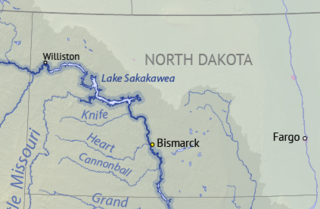
Lake Sakakawea is a large reservoir in the north central United States, impounded in 1953 by Garrison Dam, a U.S. Army Corps of Engineers dam located in the Missouri River basin in central North Dakota. Named for the Shoshone-Hidatsa woman Sakakawea, it is the largest man-made lake located entirely within North Dakota, the second largest in the United States by area after Lake Oahe, and the third largest in the United States by volume, after Lake Mead and Lake Powell.

Garrison Dam is an earth-fill embankment dam on the Missouri River in central North Dakota, U.S. Constructed by the U.S. Army Corps of Engineers from 1947 to 1953, at over 2 miles (3.2 km) in length, the dam is the fifth-largest earthen dam in the world. The reservoir impounded by the dam is Lake Sakakawea, which extends to Williston and the confluence with the Yellowstone River, near the Montana border. The dam and resulting reservoir inundated approximately one-sixth (16.6%) to one-fourth (25%) of Fort Berthold Indian Reservation's land, resulting in the loss of homes, farmland, and community infrastructure for the Three Affiliated Tribes.
The Mandan, Hidatsa, and Arikara Nation, also known as the Three Affiliated Tribes, is a Native American Nation resulting from the alliance of the Mandan, Hidatsa, and Arikara peoples, whose native lands ranged across the Missouri River basin extending from present day North Dakota through western Montana and Wyoming.

The Hidatsa are a Siouan people. They are enrolled in the federally recognized Three Affiliated Tribes of the Fort Berthold Reservation in North Dakota. Their language is related to that of the Crow, and they are sometimes considered a parent tribe to the modern Crow in Montana.

Arikara, also known as Sahnish, Arikaree, Ree, or Hundi, are a tribe of Native Americans in North Dakota. Today, they are enrolled with the Mandan and the Hidatsa as the federally recognized tribe known as the Mandan, Hidatsa, and Arikara Nation.

The Mandan are a Native American tribe of the Great Plains who have lived for centuries primarily in what is now North Dakota. They are enrolled in the Three Affiliated Tribes of the Fort Berthold Reservation. About half of the Mandan still reside in the area of the reservation; the rest reside around the United States and in Canada.

Fort Abraham Lincoln State Park is a North Dakota state park located 7 miles (11 km) south of Mandan, North Dakota, United States. The park is home to the replica Mandan On-A-Slant Indian Village and reconstructed military buildings including the Custer House.

The Crow Creek Indian Reservation, home to Crow Creek Sioux Tribe is located in parts of Buffalo, Hughes, and Hyde counties on the east bank of the Missouri River in central South Dakota in the United States. It has a land area of 421.658 square miles (1,092.09 km2) and a 2000 census population of 2,225 persons. The major town and capital of the federally recognized Crow Creek Sioux Tribe is Fort Thompson.

The Fort Berthold Indian Reservation is a U.S. Indian reservation in western North Dakota that is home for the federally recognized Mandan, Hidatsa, and Arikara Nation, also known as the Three Affiliated Tribes. The reservation includes lands on both sides of the Missouri River. The tribal headquarters is in New Town, the 18th largest city in North Dakota.

Four Bears Bridge is one of two bridges built over the Missouri River on the Fort Berthold Reservation in the U.S. state of North Dakota. It carries North Dakota Highway 23. The current bridge which opened in 2005 is the second largest bridge in the state and replaced an earlier bridge built in 1934. The 1934 bridge was moved in 1955 following the construction of the Garrison Dam and the creation of Lake Sakakawea.
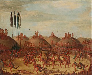
Like-a-Fishhook Village was a Native American settlement next to Fort Berthold in North Dakota, United States, established by dissident bands of the Three Affiliated Tribes, the Mandan, Arikara and Hidatsa. Formed in 1845, it was also eventually inhabited by non-Indian traders, and became important in the trade between Natives and non-Natives in the region.

Fort Buford was a United States Army Post at the confluence of the Missouri and Yellowstone rivers in Dakota Territory, present day North Dakota, and the site of Sitting Bull's surrender in 1881.
Fort Berthold was the name of two successive forts on the upper Missouri River in present-day central-northwest North Dakota. Both were initially established as fur trading posts. The second was adapted as a post for the U.S. Army. After the Army left the area, having subdued Native Americans, the fort was used by the US as the Indian Agency for the regional Arikara, Hidatsa, and Mandan Affiliated Tribes and their reservation.

Crow Flies High State Recreation Area is a scenic overlook located two miles west of New Town in Mountrail County, North Dakota. The site provides scenic views of Lake Sakakawea. Signs describe the location's role in local history, including its significance in the explorations of Lewis and Clark. The footprint of the drowned town of Sanish, now lost below the reservoir's waves, can be seen at times of low water.
Alyce Spotted Bear was a Native American educator and politician and an enrolled member of the Mandan, Hidatsa, and Arikara Nation.

Native Americans from various tribes lived in North Dakota before the arrival of settlers. With time, a number of treaties and agreements were signed between the Indians and the newcomers. Many of the treaties defined the domain of a specific group of Indians. The three maps below show the treaty territories of different Indians living in North Dakota and how the territories changed and diminished over time in the 19th century.

Arikara scouts were enlisted men from the Arikara Nation serving in the U.S. Army at different frontier posts in present-day North Dakota from 1868 to 1881. The enlistment period was six months with re-enlistment possible. Each scout received a uniform, firearm and drew rations. Scout duties ranged from carrying mail between commands to tracking down traditional enemies perceived as hostile by the Army in far ranging military campaigns. Detailed to secure the horses in located enemy camps, the scouts were often the first to engage in battle. The Arikara took part when the Army protected survey crews in the Yellowstone area in the early 1870s. They participated in the Great Sioux War of 1876 and developed into Colonel George Armstrong Custer's "… most loyal and permanent scouts …".
Raymond "Ray" Cross was an American attorney and law professor from the U.S. state of North Dakota. He was a member of the Mandan, Hidatsa, and Arikara Nation, also known as the Three Affiliated Tribes, and a former professor of American Indian Law at the University of Montana. As an attorney, Cross represented Native Americans in multiple landmark trials, including two U.S. Supreme Court cases, and successfully won a compensation claim against the U.S. government for the flooding of 156,000 acres of tribal land in North Dakota due to the construction of the Garrison Dam.
References
Citations
- 1 2 Donovan, Lauren (August 29, 2004). "Lost & Found: Low levels on Lake Sakakawea revealing several flooded towns". The Bismarck Tribune . Old Sanish. pp. 1C, 2C . Retrieved April 18, 2024– via Newspapers.com.
- 1 2 3 4 Dura, Jack (June 11, 2022). "The Story of Elbowoods". Prairie Public . Prairie Public Broadcasting. Retrieved April 17, 2024.
- 1 2 "Elbowoods alumni tell of days before the dam". The Bismarck Tribune . New Town. Associated Press. August 13, 1993. p. 11A. Retrieved April 18, 2024– via Newspapers.com.
- ↑ "Immersed Remains: Towns Submerged In America". The Lay of the Land. No. 28. Center for Land Use Interpretation. Spring 2005. Retrieved April 17, 2024.
- 1 2 3 4 5 6 7 Olien, Matt (producer and writer); Johnson, Kelly (editor and graphics) (May 20, 2019). Basketball, Water and the Lost City of Elbowoods (Television production). PBS . Retrieved April 17, 2024.
- ↑ Nelson, Dan (March 14, 1974). "Tournament of '42 Struck From Books". The Bismarck Tribune . Vol. 101, no. 62. p. 1. Retrieved April 18, 2024– via Newspapers.com.
- ↑ Field Murray et al. 2011, p. 468.
- ↑ Page 1953, p. 357.
- ↑ Field Murray et al. 2011, p. 473.
- ↑ Field Murray et al. 2011, pp. 472–473.
- ↑ Field Murray et al. 2011, p. 477.
- ↑ Field Murray et al. 2011, p. 479.
Bibliography
- Field Murray, Wendi; Nieves Zedeño, María; Hollenback, Kacy L.; Grinnell, Calvin; Crows Breast, Elgin (2011). "The remaking of Lake Sakakawea: Locating cultural viability in negative heritage on the Missouri River". American Ethnologist. 38 (3): 468–483. JSTOR 41241607 . Retrieved April 17, 2024– via JSTOR.
- Page, R. J. B. (1953). "The Garrison Dam Closure". The Military Engineer. 45 (307): 357–359. JSTOR 44561765 . Retrieved April 17, 2024– via JSTOR.
