Related Research Articles

Thurston County is a county located in the U.S. state of Washington. As of the 2010 census, its population was 252,264. The county seat and largest city is Olympia, the state capital.

Admiralty Inlet is a strait in the U.S. state of Washington connecting the eastern end of the Strait of Juan de Fuca to Puget Sound. It lies between Whidbey Island and the northeastern part of the Olympic Peninsula.
Port Orchard, part of Washington state's Puget Sound, is the strait that separates Bainbridge Island on the east from the Kitsap Peninsula on the west. It extends from Liberty Bay and Agate Pass in the north to Sinclair Inlet and Rich Passage in the south. It was named in May 1792 by George Vancouver after Harry Masterman Orchard, ship's clerk of Vancouver's ship Discovery.

The Salish Sea is a marginal sea of the Pacific Ocean located in the Canadian province of British Columbia and the U.S. state of Washington. It includes the Strait of Georgia, Strait of Juan de Fuca, Puget Sound, and an intricate network of connecting channels and adjoining waterways.

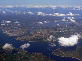
Budd Inlet is an inlet located at the southern end of Puget Sound in Thurston County, Washington. It is the southernmost arm of Puget Sound.

Herron Island is an island in central Case Inlet in the southern part of Puget Sound in the U.S. state of Washington. The Pierce County island has a land area of 1.2326 km² and a population of 152 persons as of the 2000 census.

The Vancouver Expedition (1791–1795) was a four-and-a-half-year voyage of exploration and diplomacy, commanded by Captain George Vancouver of the Royal Navy. The British expedition circumnavigated the globe and made contact with five continents. The expedition at various times included between two and four vessels, and up to 153 men, all but six of whom returned home safely.

Pickering Passage is a strait, in the southern end of part of Puget Sound in the U.S. state of Washington. Entirely within Mason County, the Pickering Passage separates Hartstine Island from the mainland, and connects Totten Inlet with the north end of Case Inlet.

Totten Inlet lies in the southern end of Puget Sound in the U.S. state of Washington. The inlet extends 9 miles (14 km) southwest from the western end of Squaxin Passage, and much of the county line between Mason and Thurston counties runs down the center of it. A spit extends west for about 300 feet (91 m) from Steamboat Island. The inlet shoals gradually to near Burns Point, 100 feet high, on the south shore, where it bares at low tide.
Carr Inlet, in southern Puget Sound in the U.S. state of Washington, is an arm of water between Key Peninsula and Gig Harbor Peninsula. Its southern end is connected to the southern basin of Puget Sound. Northward, it separates McNeil Island and Fox Island as well as the peninsulas of Key and Gig Harbor. The northern end of Carr Inlet is named Henderson Bay, Washington, which feeds into Burley Lagoon.
Case Inlet, in southern Puget Sound in the U.S. state of Washington, is an arm of water between Key Peninsula on the east and Hartstine Island on the west. Its northern end, called North Bay, reaches nearly to Hood Canal, creating the defining isthmus of Kitsap Peninsula. Case Inlet is the boundary between Pierce County and Mason County. The southern end of Case Inlet is connected to Nisqually Reach, part of the southern basin of Puget Sound. Herron Island lies in Case Inlet.

Priest Point Park is a public park located in Olympia, Washington. Established in 1905, it was the city's first waterfront park, providing access to the Budd Inlet of Puget Sound.
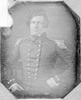
Henry Eld was a United States Navy officer, geographer, and Antarctic explorer.
Ketron Island is an island and a census-designated place (CDP) in Pierce County, Washington, United States. The island had a population of 24 persons according to the 2000 census, and 17 persons at the 2010 census.
Henderson Inlet is a small, southern inlet of Puget Sound, Washington state, situated between Budd Inlet to the west and Nisqually Reach to the east. It is located in Thurston County and the nearest city is Olympia, the state capital. Henderson Inlet was named in 1841 by Charles Wilkes, commander of the United States Exploring Expedition, after James Henderson, who served as quartermaster. A variant name is "South Bay".
Indian Creek is a stream in Thurston County in the U.S. state of Washington. It is a 3-mile Olympian creek. Its source is a wetland along the northern end of South Bay Road. It enters Budd Inlet at East Bay, having first joined with Moxlie Creek. It can most easily be accessed between Boulevard Road and Frederick Road along the Karen Fraser Woodland Trail. American Indian settlements near the creek's course may account for the name.
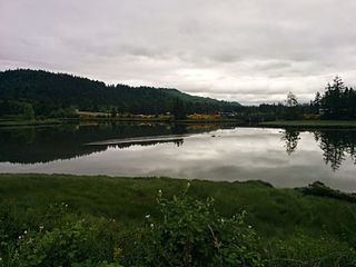
Mud Bay is the southernmost reach of Puget Sound, at Eld Inlet just outside the city limits of Olympia, Washington. The name Eld Inlet was officially bestowed after a member of the U.S. Navy's Wilkes Expedition, but "Mud Bay" is a local, informal adoption.
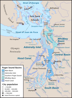
South Puget Sound is the southern reaches of Puget Sound in Southwest Washington, in the United States' Pacific Northwest. It is one of five major basins encompassing the entire Sound, and the shallowest basin, with a mean depth of 37 meters (121 ft). Exact definitions of the region vary: the state's Department of Fish and Wildlife counts all of Puget Sound south of the Tacoma Narrows for fishing regulatory purposes. The same agency counts Mason, Jefferson, Kitsap, Pierce and Thurston Counties for wildlife management. The state's Department of Ecology defines a similar area south of Colvos Passage.
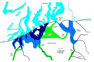
During the Vashon Glaciation a series of lakes formed along the southern margin of the Cordilleran Ice Cap. In the Puget Sound depression, a series of lakes developed, of which Lake Russell was the largest and the longest lasting. Early Lake Russell’s surface was at 160 ft (49 m) above sea level, draining across the divide at Shelton, Washington into early Glacial Lake Russell. When the ice margin receded northward, the lake expanded. When it reached the Clifton channel outlet, the water levels dropped to 120 ft (37 m) above sea level. The new longer and lower level lake is referred to as Lake Hood. The glacier continued to retreat until the northern outlet of the Hood Canal was reached as the water level equalized with Glacial Lake Russell becoming part of that body of water.
McLane Creek is a stream in Thurston County in the U.S. state of Washington. It enters Puget Sound at the southern end of Mud Bay on Eld Inlet.
References
- ↑ "Deschutes River watershed area: Budd Inlet - Washington State Department of Ecology". ecology.wa.gov. Retrieved 2020-10-01.
- ↑ Phillips, James W. (1971). Washington State Place Names . University of Washington Press. pp. 19, 44. ISBN 0-295-95158-3.
- ↑ "Thurston County Place Names: A Heritage Guide" (PDF). Thurston County Historical Commission. 1992. p. 23. Retrieved 28 March 2018.
- ↑ Roberts, John E. (2005). A Discovery Journal: George Vancouver's First Survey Season - 1792. Trafford Publishing. p. 62. ISBN 978-1-4120-7097-3.
- ↑ U.S. Geological Survey Geographic Names Information System: Eld Inlet
| Authority control |
|
|---|
Coordinates: 47°4′57″N122°59′21″W / 47.08250°N 122.98917°W
| | This Thurston County, Washington state location article is a stub. You can help Wikipedia by expanding it. |