Elk Rapids, Michigan

Last updated

Elk Rapids, Michigan
Village of Elk Rapids
Elk Rapids, Michigan (July 2019).jpg
Downtown Elk Rapids along River Street
Elk Rapids (village), MI location.png
Location within Antrim County
USA Michigan location map.svg
Red pog.svg
Elk Rapids
Location within the state of Michigan
Coordinates: 44°53′49″N85°24′38″W / 44.89694°N 85.41056°W / 44.89694; -85.41056
Country Flag of the United States.svg United States
State Flag of Michigan.svg  Michigan
County Antrim
Township Elk Rapids
Platted 1852
Incorporated1900
Government
  Type Village council
  PresidentJames Janisse
   Clerk Caroline Kennedy
Area
[1]
  Total2.01 sq mi (5.20 km2)
  Land1.65 sq mi (4.27 km2)
  Water0.36 sq mi (0.93 km2)
Elevation
597 ft (182 m)
Population
 (2020)
  Total1,529
  Density926.67/sq mi (357.68/km2)
Time zone UTC-5 (Eastern (EST))
  Summer (DST) UTC-4 (EDT)
ZIP code(s)
49629
Area code 231
FIPS code 26-25320 [2]
GNIS feature ID0625459 [3]
Website www.elkrapids.org

Elk Rapids is a village in the U.S. state of Michigan. The village is the largest incorporated community in Antrim County, with a population of 1,529 at the 2020 census. The village is located within Elk Rapids Township, in the southwest of Antrim County, and is on the shore of Grand Traverse Bay, a bay of Lake Michigan. Elk Rapids is located about 12 miles (19 km) southwest of Bellaire, the county seat, and about 13 miles (21 km) northeast of Traverse City, the largest city in Northern Michigan.

Contents

History

The first settler in the Elk Rapids area was Abram S. Wadsworth, from Connecticut. Wadsworth platted the area in 1852, calling it Stevens. A post office opened in 1854. In 1858, Wadsworth renamed the area to Elk Rapids, after finding a pair of elk antlers near the mouth of the later-named Elk River. [4] In 1863, Antrim County was organized, and Elk Rapids was made the county seat. However, the seat was moved to the more centrally-located Bellaire in 1879. [5] In 1892, Elk Rapids became a station on a spur of the Chicago and West Michigan Railway. [6] The town was incorporated as a village in 1900. [4]

Geography

According to the United States Census Bureau, the village has a total area of 2.01 square miles (5.21 km2), of which, 1.65 square miles (4.27 km2) of it is land and 0.36 square miles (0.93 km2) is water. [7]

The village of Elk Rapids is located on an isthmus. To the east of the village is Elk Lake, the 15th-largest inland lake in Michigan and the lowest member of the Elk River Chain of Lakes. To the west of the village is the East Arm of Grand Traverse Bay, a large bay of Lake Michigan. The Elk River bisects the village, flowing northwesterly from Elk Lake to Grand Traverse Bay.

Elk Rapids lies about 2 miles (3.2 km) north of the Grand Traverse County line.

Climate

According to the Köppen climate classification, Elk Rapids has a humid continental climate, labelled Dfb on climate maps. [8] This climatic region has large seasonal temperature differences, with warm to hot (and often humid) summers and cold (sometimes severely cold) winters.

Climate data for Elk Rapids, Michigan
MonthJanFebMarAprMayJunJulAugSepOctNovDecYear
Mean daily maximum °C (°F)29
(−2)
31
(−1)
40
(4)
53
(12)
65
(18)
75
(24)
80
(27)
78
(26)
70
(21)
57
(14)
46
(8)
34
(1)
55
(13)
Mean daily minimum °C (°F)17
(−8)
16
(−9)
22
(−6)
32
(0)
41
(5)
52
(11)
57
(14)
57
(14)
50
(10)
40
(4)
32
(0)
22
(−6)
37
(3)
Average precipitation mm (inches)1.4
(36)
0.9
(23)
1.5
(38)
2.1
(53)
2.7
(69)
3.2
(81)
2.8
(71)
3.5
(89)
3.5
(89)
3.4
(86)
1.9
(48)
1.6
(41)
28.4
(720)
Source: Weatherbase [9]

Demographics

Historical population
CensusPop.Note
1880 620
1910 1,673
1920 684−59.1%
1930 615−10.1%
1940 69012.2%
1950 88928.8%
1960 1,01514.2%
1970 1,24923.1%
1980 1,50420.4%
1990 1,6268.1%
2000 1,7004.6%
2010 1,642−3.4%
2020 1,529−6.9%
U.S. Decennial Census [10]

2010 census

As of the census [11] of 2010, there were 1,642 people, 791 households, and 478 families residing in the village. The population density was 995.2 inhabitants per square mile (384.2/km2). There were 1,179 housing units at an average density of 714.5 per square mile (275.9/km2). The racial makeup of the village was 96.6% White, 0.7% African American, 1.2% Native American, 0.5% Asian, 0.1% Pacific Islander, 0.2% from other races, and 0.7% from two or more races. Hispanic or Latino of any race were 1.3% of the population.

There were 791 households, of which 21.0% had children under the age of 18 living with them, 48.4% were married couples living together, 9.6% had a female householder with no husband present, 2.4% had a male householder with no wife present, and 39.6% were non-families. 34.8% of all households were made up of individuals, and 17.9% had someone living alone who was 65 years of age or older. The average household size was 2.07 and the average family size was 2.63.

The median age in the village was 52.4 years. 18.6% of residents were under the age of 18; 5.6% were between the ages of 18 and 24; 16.3% were from 25 to 44; 30.9% were from 45 to 64; and 28.7% were 65 years of age or older. The gender makeup of the village was 46.5% male and 53.5% female.

2000 census

As of the census [2] of 2000, there were 1,700 people, 769 households, and 483 families residing in the village. The population density was 1,014.3 inhabitants per square mile (391.6/km2). There were 1,056 housing units at an average density of 630.1 per square mile (243.3/km2). The racial makeup of the village was 97.00% White, 0.29% African American, 1.00% Native American, 0.12% Asian, 0.24% Pacific Islander, 0.59% from other races, and 0.76% from two or more races. Hispanic or Latino of any race were 2.12% of the population.

There were 769 households, out of which 27.8% had children under the age of 18 living with them, 49.7% were married couples living together, 10.8% had a female householder with no husband present, and 37.1% were non-families. 34.6% of all households were made up of individuals, and 17.3% had someone living alone who was 65 years of age or older. The average household size was 2.20 and the average family size was 2.83.

In the village, the population was spread out, with 24.2% under the age of 18, 5.1% from 18 to 24, 23.2% from 25 to 44, 27.5% from 45 to 64, and 19.9% who were 65 years of age or older. The median age was 43 years. For every 100 females, there were 94.5 males. For every 100 females age 18 and over, there were 83.2 males.

The median income for a household in the village was $31,382, and the median income for a family was $45,179. Males had a median income of $30,845 versus $23,167 for females. The per capita income for the village was $19,735. About 7.6% of families and 8.2% of the population were below the poverty line, including 11.1% of those under age 18 and 5.8% of those age 65 or over.

Education

Public K-12 education in Elk Rapids is served by the Elk Rapids Schools district. [12] The district operates Lakeland Elementary School, Cherryland Middle School, and Elk Rapids High School within village limits, as well as Mill Creek Elementary School in the nearby community of Williamsburg, in Grand Traverse County. [13]

Major highways

Images

Related Research Articles

<span class="mw-page-title-main">Bellaire, Michigan</span> Village in Michigan, United States

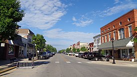
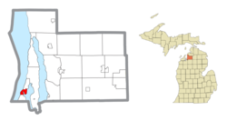
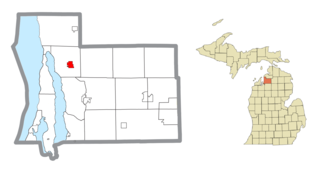
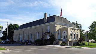
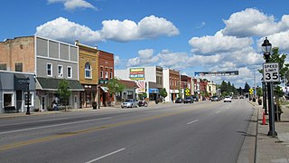
Bellaire is a village and the county seat of Antrim County, Michigan, United States. The population was 1,053 in 2020 census.

<span class="mw-page-title-main">Central Lake, Michigan</span> Village in Michigan, United States

Central Lake is a village in Antrim County in the U.S. state of Michigan. The population was 960 at the 2020 census. The village is located within Central Lake Township.

<span class="mw-page-title-main">Central Lake Township, Michigan</span> Civil township in Michigan, United States

Central Lake Township is a civil township of Antrim County in the U.S. state of Michigan. The population was 2,159 at the 2020 census. The village of Central Lake is located within the township.

<span class="mw-page-title-main">Elk Rapids Township, Michigan</span> Civil township in Michigan, United States

Elk Rapids Township is a civil township of Antrim County in the U.S. state of Michigan. The population was 2,521 at the 2020 census. The village of Elk Rapids is located within the township.

<span class="mw-page-title-main">Ellsworth, Michigan</span> Village in Michigan, United States

Ellsworth is a village in Antrim County in the U.S. state of Michigan. The population was 367 at the 2020 census. The village is located within Banks Township.

<span class="mw-page-title-main">Helena Township, Michigan</span> Civil township in Michigan, United States

Helena Township is a civil township of Antrim County in the U.S. state of Michigan. The population was 937 at the 2020 census. Helena Township was organized in 1865 by a division of Milton Township. It was named for Helena M. Thayer.

<span class="mw-page-title-main">Mancelona, Michigan</span> Village in Antrim County, Michigan, US

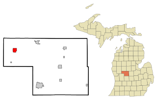
Mancelona is a village in the Northern Lower Peninsula of the U.S. state of Michigan. Part of Mancelona Township, the village is located within Antrim County. Its population was 1,344 at the 2020 census.

<span class="mw-page-title-main">Mancelona Township, Michigan</span> Civil township in Michigan, United States

Mancelona Township is a civil township of Antrim County in the U.S. state of Michigan. The population was 4,311 at the 2020 census.

<span class="mw-page-title-main">Milton Township, Antrim County, Michigan</span> Civil township in Michigan, United States

Milton Township is a civil township of Antrim County in the U.S. state of Michigan. The population was 2,355 at the 2020 census.

<span class="mw-page-title-main">Star Township, Michigan</span> Civil township in Michigan, United States

Star Township is a civil township of Antrim County in the U.S. state of Michigan. The population was 1,028 at the 2020 census.

<span class="mw-page-title-main">Torch Lake Township, Antrim County, Michigan</span> Civil township in Michigan, United States

Torch Lake Township is a civil township of Antrim County in the U.S. state of Michigan. Located in the Northern Lower Peninsula, the township comprises an isthmus between the eponymous Torch Lake and Grand Traverse Bay, a bay of Lake Michigan. As of the 2020 census, the township population was 1,212, a slight increase from 1,194 at the 2010 census.

<span class="mw-page-title-main">Blaine Township, Michigan</span> Civil township in Michigan, United States

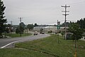
Blaine Township is a civil township of Benzie County in the U.S. state of Michigan. As of the 2020 census, the township population was 484. It is located in the southwest portion of the county. There are no significant population centers in the township; the nearest towns are Arcadia to the south, Benzonia to the northeast, and Elberta to the northwest. M-22 is the township's main thoroughfare.

<span class="mw-page-title-main">Acme Township, Michigan</span> Civil township in Michigan, United States

Acme Township is a civil township of Grand Traverse County in the U.S. state of Michigan. As of the 2020 census, the township population was 4,456, a slight increase from 4,375 at the 2010 census. The southwestern portion of the township is largely urbanized, due to its proximity to Traverse City. Much of the rest of the township is agricultural, with the area being a cherry growing hotspot. The township lies upon the East Arm of Grand Traverse Bay, a bay of Lake Michigan. A portion of the township is within the Grand Traverse Reservation.

<span class="mw-page-title-main">Fife Lake, Michigan</span> Village in Michigan, United States

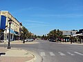
Fife Lake is a village in southeastern Grand Traverse County in the U.S. state of Michigan. Its population was 456 at the 2020 census, up from 443 at the 2010 census. The village is part of the Traverse City metropolitan area, and lies upon the shore of the lake of the same name.

<span class="mw-page-title-main">Whitewater Township, Michigan</span> Civil township in Michigan, United States

Whitewater Township is a civil township of Grand Traverse County in the U.S. state of Michigan. The population was 2,688 at the 2020 census, an increase from 2,597 at the 2010 census. Whitewater Township includes shores on Elk Lake and Lake Skegemog, two large lakes in the Chain of Lakes. A portion of the township is within the Grand Traverse Indian Reservation.

<span class="mw-page-title-main">Clearwater Township, Michigan</span> Civil township in Michigan, United States

Clearwater Township is a civil township of Kalkaska County in the U.S. state of Michigan. As of the 2020 census, the township population was 2,497.

<span class="mw-page-title-main">Kalkaska, Michigan</span> Village in Michigan, United States

Kalkaska is a village in the U.S. state of Michigan. Kalkaska is the county seat and only incorporated community of Kalkaska County, and is considered part of Northern Michigan. Its population was 2,132 at the 2020 census, an increase from 2,020 at the 2010 census.

<span class="mw-page-title-main">Howard City, Michigan</span> Village in Michigan, United States

Howard City is a village in Montcalm County in the U.S. state of Michigan. The population was 1,835 at the 2020 census. The village is within Reynolds Township.

<span class="mw-page-title-main">Oliver Township, Kalkaska County, Michigan</span> Civil township in Michigan, United States

Oliver Township is a civil township of Kalkaska County in the U.S. state of Michigan. The population was 292 at the 2020 census, making it the least-populous township in Kalkaska County. Oliver Township is part of the Traverse City micropolitan area, and is considered part of Northern Michigan.

<span class="mw-page-title-main">Bingham Township, Leelanau County, Michigan</span> Civil township in Michigan, United States

Bingham Township is a civil township of Leelanau County in the U.S. state of Michigan. As of the 2020 census, the township population was 2,577. The township is named for Kinsley S. Bingham, a U.S. Representative, U.S. Senator, and Governor of Michigan.

References

  1. "2020 U.S. Gazetteer Files". United States Census Bureau. Retrieved May 21, 2022.
  2. 1 2 "U.S. Census website". United States Census Bureau . Retrieved January 31, 2008.
  3. "US Board on Geographic Names". United States Geological Survey. October 25, 2007. Retrieved January 31, 2008.
  4. 1 2 Romig, Walter (1986). Michigan Place Names: The History and Naming of More Than Five Thousand Past and Present Michigan Communities. Detroit: Wayne State University Press. p. 179. ISBN   0-8143-1838-X.
  5. "History of Antrim County, MI". genealogytrails.com. Retrieved January 21, 2023.
  6. "michiganrailroads.com - Evolution Map - Lower - 1892". www.michiganrailroads.com. Archived from the original on October 28, 2022. Retrieved January 21, 2023.
  7. "US Gazetteer files 2010". United States Census Bureau. Archived from the original on January 25, 2012. Retrieved November 25, 2012.
  8. Climate Summary for Elk Rapids, Michigan
  9. "Weatherbase.com". Weatherbase. 2024. Retrieved on May 26, 2024.
  10. "Census of Population and Housing". Census.gov. Retrieved June 4, 2015.
  11. "U.S. Census website". United States Census Bureau . Retrieved November 25, 2012.
  12. "Elk Rapids Home". www.erschools.com. Retrieved May 26, 2024.
  13. "Schools". www.erschools.com. Retrieved May 26, 2024.