Ellsworth, Michigan

Last updated

Ellsworth, Michigan
Village of Ellsworth
Ellsworth, MI location.png
Location within Antrim County
USA Michigan location map.svg
Red pog.svg
Ellsworth
Location within the state of Michigan
Coordinates: 45°10′04″N85°14′42″W / 45.16778°N 85.24500°W / 45.16778; -85.24500
Country United States
State Michigan
County Antrim
Township Banks
Incorporated1938
Government
  Type Village council
  PresidentHugh Campbell
   Clerk Marlene Drenth
Area
[1]
  Total0.83 sq mi (2.14 km2)
  Land0.75 sq mi (1.94 km2)
  Water0.08 sq mi (0.21 km2)
Elevation
659 ft (201 m)
Population
 (2020)
  Total367
  Density490.64/sq mi (189.55/km2)
Time zone UTC-5 (Eastern (EST))
  Summer (DST) UTC-4 (EDT)
ZIP code(s)
49729
Area code 231
FIPS code 26-25420 [2]
GNIS feature ID0625495 [3]
Website villageofellsworthmi.com

Ellsworth is a village in Antrim County in the U.S. state of Michigan. The population was 367 at the 2020 census. [4] The village is located within Banks Township.

Contents

The village is primarily a bedroom community with its primary industry being gravel and other aggregates. Agriculture and forestry are also important industries. Ellsworth is home to a small annual festival called the Pig Roast, which involves a parade and horse pulls and roast pork. Ellsworth is the seat of Banks Township, which also includes the community of Atwood and several cherry orchards. Ellsworth's main governing body is the Ellsworth Village Council. The town is named after Elmer Ephraim Ellsworth, the first Union officer to die in the American Civil War.

History

The village of Ellsworth was founded in 1881. It quickly took in the previous villages of Needmore and Ox Bow. It was incorporated as a village in 1938. [5]

Geography

According to the United States Census Bureau, the village has a total area of 0.80 square miles (2.07 km2), of which, 0.72 square miles (1.86 km2) of it is land and 0.08 square miles (0.21 km2) is water. [6]

Ellsworth is about 40 miles (64 km) northeast of Traverse City. [7]

Demographics

Historical population
CensusPop.Note
1940 347
1950 3696.3%
1960 3864.6%
1970 362−6.2%
1980 43620.4%
1990 418−4.1%
2000 48315.6%
2010 349−27.7%
2020 3675.2%
U.S. Decennial Census [8]

2010 census

As of the census [9] of 2010, there were 349 people, 142 households, and 100 families residing in the village. The population density was 484.7 inhabitants per square mile (187.1/km2). There were 186 housing units at an average density of 258.3 per square mile (99.7/km2). The racial makeup of the village was 97.1% White, 0.6% African American, 0.9% from other races, and 1.4% from two or more races. Hispanic or Latino of any race were 0.6% of the population.

There were 142 households, of which 30.3% had children under the age of 18 living with them, 58.5% were married couples living together, 10.6% had a female householder with no husband present, 1.4% had a male householder with no wife present, and 29.6% were non-families. 28.2% of all households were made up of individuals, and 11.9% had someone living alone who was 65 years of age or older. The average household size was 2.42 and the average family size was 2.94.

The median age in the village was 42.9 years. 24.9% of residents were under the age of 18; 4.7% were between the ages of 18 and 24; 22.6% were from 25 to 44; 32.4% were from 45 to 64; and 15.5% were 65 years of age or older. The gender makeup of the village was 47.9% male and 52.1% female.

2000 census

As of the census [2] of 2000, there were 483 people, 174 households, and 132 families residing in the village. The population density was 652.9 inhabitants per square mile (252.1/km2). There were 204 housing units at an average density of 275.8 per square mile (106.5/km2). The racial makeup of the village was 96.48% White, 0.21% African American, 0.41% Native American, 1.04% from other races, and 1.86% from two or more races. Hispanic or Latino of any race were 1.04% of the population.

There were 174 households, out of which 43.1% had children under the age of 18 living with them, 61.5% were married couples living together, 10.3% had a female householder with no husband present, and 24.1% were non-families. 20.7% of all households were made up of individuals, and 11.5% had someone living alone who was 65 years of age or older. The average household size was 2.78 and the average family size was 3.17.

In the village, the population was spread out, with 31.1% under the age of 18, 7.5% from 18 to 24, 29.8% from 25 to 44, 21.1% from 45 to 64, and 10.6% who were 65 years of age or older. The median age was 33 years. For every 100 females, there were 96.3 males. For every 100 females age 18 and over, there were 91.4 males.

The median income for a household in the village was $38,125, and the median income for a family was $45,694. Males had a median income of $34,375 versus $26,719 for females. The per capita income for the village was $16,781. About 5.5% of families and 7.3% of the population were below the poverty line, including 9.2% of those under age 18 and 19.0% of those age 65 or over.

Related Research Articles

Springfield is a city in Bay County, Florida, United States, east of Panama City. It is part of the Panama City–Lynn Haven–Panama City Beach Metropolitan Statistical Area. Springfield was incorporated on February 12, 1935. The population was 8,075 at the 2020 census.

<span class="mw-page-title-main">Lorraine, Kansas</span> City in Ellsworth County, Kansas

Lorraine is a city in Ellsworth County, Kansas, United States. As of the 2020 census, the population of the city was 137.

<span class="mw-page-title-main">Geneseo, Kansas</span> City in Rice County, Kansas

Geneseo is a city in Rice County, Kansas, United States. As of the 2020 census, the population of the city was 236.

Dedham is a town in Hancock County, Maine, United States. The population was 1,648 at the 2020 census. The town includes the site of a Cold War airplane crash on Bald Mountain.

Surry is a town in Hancock County, Maine, United States. The population was 1,632 at the 2020 census.

<span class="mw-page-title-main">Ellsworth Township, Michigan</span> Civil township in Michigan, United States

Ellsworth Township is a civil township of Lake County in the U.S. state of Michigan. The population was 736 at the 2020 census.

<span class="mw-page-title-main">Luther, Michigan</span> Village in Michigan, United States

Luther is a village in Lake County in the U.S. state of Michigan. The population was 332 at the 2020 census. The village is on the boundary between Newkirk Township on the west and Ellsworth Township on the east, with about half of the village in each. It is the site of Hillsdale College's G.H. Gordon Biological Research Station.

<span class="mw-page-title-main">Ellsworth, Minnesota</span> City in Minnesota, United States

Ellsworth is a city in Nobles County, Minnesota, United States. The population was 463 at the 2010 census. The local school district is the Ellsworth Public School.

<span class="mw-page-title-main">Foster, Missouri</span> Village in Missouri, United States

Foster is a village in Bates County, Missouri, and part of the Kansas City metropolitan area within the United States. The population was 76 at the 2020 census.

<span class="mw-page-title-main">Westwood, Missouri</span> Village in Missouri, United States

Westwood is a village in west St. Louis County, Missouri, United States. The population was 316 at the 2020 census.

<span class="mw-page-title-main">Cleves, Ohio</span> City in Ohio, United States

Cleves is a village in Miami Township, Hamilton County, Ohio, United States. Located along the Ohio River, it is a western suburb of Cincinnati. The population was 3,414 at the 2020 census.

<span class="mw-page-title-main">West Liberty, West Virginia</span> Town in West Virginia, United States

West Liberty is a town in Ohio County, West Virginia, United States. The population was 1,557 at the 2020 census. It is part of the Wheeling metropolitan area.

<span class="mw-page-title-main">Rock Springs, Wisconsin</span> Village in Wisconsin, United States

Rock Springs is a village in Sauk County, Wisconsin, United States, along the Baraboo River. The population was 362 at the 2010 census.

<span class="mw-page-title-main">Troy, Sauk County, Wisconsin</span> Town in Wisconsin, United States

The Town of Troy is located in Sauk County, Wisconsin, United States. The population was 773 at the 2000 census. The unincorporated communities of Black Hawk, Cassell, and Witwen are located in the town.

<span class="mw-page-title-main">Wild Rose, Wisconsin</span> Village in Wisconsin, United States

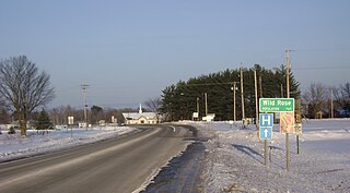
Wild Rose is a village in Waushara County, Wisconsin, United States. The population was 725 at the 2010 census.

<span class="mw-page-title-main">Box Elder, South Dakota</span> City in South Dakota, United States

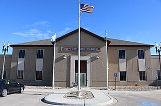
Box Elder is a city in Pennington and Meade counties in the State of South Dakota. The population was 11,746 at the 2020 census, making it the 11th most populous city in South Dakota. Ellsworth Air Force Base lies on the northeast side of the city.

<span class="mw-page-title-main">Ellsworth, Wisconsin</span> Village in Wisconsin, United States

Ellsworth is a village in and the county seat of Pierce County, Wisconsin, United States. The population was 3,348 at the 2020 census. The village is adjacent to the Town of Ellsworth and now incorporates the formerly separate district known as East Ellsworth. The municipality of Ellsworth and its surroundings are slowly becoming incorporated into the Twin Cities Metro Area.

<span class="mw-page-title-main">Ironton, Wisconsin</span> Village in Wisconsin, United States

Ironton is a village in Sauk County, Wisconsin, United States, along the Little Baraboo River. The population was 253 at the 2010 census. The village is located within the Town of Ironton.

Ironton is a town in Sauk County, Wisconsin, United States. The population was 650 at the 2000 census. The town was named from deposits of iron ore in the area. The Village of Ironton is located within the town.

<span class="mw-page-title-main">La Valle (town), Wisconsin</span>

The Town of La Valle is located in Sauk County, Wisconsin, United States. La Valle is a name derived from French meaning "the valley". The population was 1,203 at the 2000 census. The Village of La Valle is located within the town.

References

  1. "2020 U.S. Gazetteer Files". United States Census Bureau. Retrieved May 21, 2022.
  2. 1 2 "U.S. Census website". United States Census Bureau . Retrieved January 31, 2008.
  3. "US Board on Geographic Names". United States Geological Survey. October 25, 2007. Retrieved January 31, 2008.
  4. "Ellsworth village, Antrim County, Michigan - Census Bureau Profile". United States Census Bureau. Retrieved February 16, 2024.
  5. Walter Romig, Michigan Place Names, p. 180
  6. "US Gazetteer files 2010". United States Census Bureau. Archived from the original on January 25, 2012. Retrieved November 25, 2012.
  7. Haddix, Carol. "There Is Such A Thing As Michigan Cuisine, And Tapawingo Serves." Chicago Tribune . June 30, 1985. Retrieved on October 19, 2013. " Ellsworth, a town of 400 about 40 miles northeast of Traverse City. "
  8. "Census of Population and Housing". Census.gov. Retrieved June 4, 2015.
  9. "U.S. Census website". United States Census Bureau . Retrieved November 25, 2012.

45°09′56″N85°14′46″W / 45.16556°N 85.24611°W / 45.16556; -85.24611