Ellisburg, New York

Last updated

Ellisburg, New York
USA New York location map.svg
Red pog.svg
Ellisburg
Usa edcp location map.svg
Red pog.svg
Ellisburg
Coordinates: 43°44′N76°08′W / 43.733°N 76.133°W / 43.733; -76.133
CountryUnited States
State New York
County Jefferson
Government
  Type Town Council
   Town Supervisor {{nowra Douglas Shelmidine (R)}}
   Town Council
Members
Area
[1]
  Total86.61 sq mi (224.32 km2)
  Land85.22 sq mi (220.72 km2)
  Water1.39 sq mi (3.60 km2)  1.60%
Population
 (2020) [2]
  Total3,352
  Density39.33/sq mi (15.19/km2)
Time zone UTC-5 (Eastern (EST))
  Summer (DST) UTC-4 (EDT)
FIPS code 36-045-24086

Ellisburg is an incorporated town in Jefferson County, New York. The population was 3,352 at the time of the 2020 census. [2] The town is in the southwestern corner of the county and is south of Watertown. Ellisburg is named after early European-American landowners. Among the villages in the town is Ellisburg.

Contents

History

This was long the territory of various cultures of indigenous peoples. Prehistoric remains show evidence of indigenous occupation for thousands of years prior to European encounter. The St. Lawrence Iroquoians had villages along the upper St. Lawrence River from the 1300s into the late 1500s. Along the southern areas of the Great Lakes, the Five Nations of the Iroquois Confederacy controlled territory from present-day New York into Pennsylvania and Ohio and south into Virginia. In historic times the Onondaga people were concentrated in this area. The Five Nations together identified as the Haudenosaunee.

In the mid-19th century, E.G. Squier conducted a survey of ancient Native American works for the Smithsonian Institution, publishing drawings, plans, and maps. He found evidence of Iroquois longhouses and burial grounds in this area, as well as numerous artifacts and remnants of what were believed to be defensive Iroquois fortifications along Sandy Creek from the early eighteenth century, for protection against French colonists and First Nations. [3]

Samuel de Champlain and other French explorers and missionaries visited the area of the present-day town in the 17th century. After the French established a colony in New France (Quebec), their traders did business with numerous Iroquois villages, primarily those of the Onondaga and especially the Mohawk peoples. Later these peoples primarily traded with Dutch and English colonists in present-day New York, from Albany west along the Mohawk River. Most of the Iroquois nations allied with the British during the American Revolutionary War. As a result of Great Britain's defeat in the American Revolutionary War and cession of its territories in the Thirteen Colonies, the United States forced the Iroquois to cede most of their territory in present-day New York. The Crown compensated the nations by setting up land reserves in Upper Canada (now Ontario). There were already Mohawk-dominated villages along the St. Lawrence River in Quebec, near Montreal and upriver, which had started near Jesuit missions.

Following the war, New York State made five million acres of former Iroquois land available for public purchase; land speculators bought large tracts of land for development. They envisioned the rise of villages and farms. As part of such postwar land speculation, Alexander Macomb bought thousands of acres in Macomb's Purchase. Thousands of migrants from New England flooded into upstate and western New York in the postwar years, and the area also attracted immigrants from the British Isles and France. Marvel and Lyman Ellis purchased the town land from Macomb's Purchase and first settled around 1797 near what became Ellisburg village. Originally the name was spelled "Ellisburgh".

The town was organized in 1803 from the town of Mexico (now in Oswego County) before the formation of Jefferson County.

When President Thomas Jefferson established an embargo against trade with Great Britain in 1807 prior to the War of 1812, it adversely affected the thriving trade among the towns in upstate New York and Canada. In the tiny village of nearby Sackets Harbor on Lake Ontario, the US Navy built and operated a major shipyard employing 3,000 workers during the war; they completed 12 warships to be used for the battles on the Great Lakes and were critical to the US being able to fight against the British there. Thousands more military assigned to the Army and Navy were stationed at Sackets Harbor. By the fall of 1814, the village had become the third-largest population center in the entire state, after Albany and New York. In 1814 during the War of 1812, Americans defeated a British invasion force at the Battle of Big Sandy Creek in Ellisburg.

Settlers and developers had expected upstate New York to thrive due to trade with Canada, but this was severely interrupted by the war. Following the war, major changes followed the construction and opening of the Erie Canal in 1824 through the Mohawk River Valley and it drew development westward. It opened transportation and connection with the Midwest and Great Lakes communities, which could send their produce and commodities to New York City. Towns of Jefferson County generally were bypassed by such western development, resulting in many of their young people migrating west to Ohio, Michigan and Wisconsin from the mid-nineteenth century.

Watertown, New York, however, developed as a major industrial city at the turn of the twentieth century. Its paper and other factories were powered by the Black River. The industrial wealth generated by such manufacturing resulted in the city having one of the highest numbers of millionaires per capita in the early 20th century.

The community of Belleville incorporated as a village in 1860. The community of Mannsville was incorporated as a village in 1879. Ellisburg village was incorporated in 1895. In 1930, Belleville abandoned its status as a village. [4]

Geography

According to the United States Census Bureau, the town has a total area of 86.6 square miles (224.3 km2), of which 85.2 square miles (220.7 km2) are land and 1.4 square miles (3.6 km2), or 1.60%, are water. [1] The western boundary of Ellisburg is Lake Ontario, and the southern town line is the border of Oswego County.

Interstate 81 passes through the eastern side of the town. U.S. Route 11 runs parallel to and just east of the interstate. New York State Route 3, a north-south highway, runs down the western side of Ellisburg. New York State Route 193, an east-west highway, intersects north-south highway New York State Route 289 at Ellisburg village.

Demographics

Historical population
CensusPop.Note
1820 3,531
1830 5,29249.9%
1840 5,3491.1%
1850 5,5243.3%
1860 5,6141.6%
1870 4,822−14.1%
1880 4,810−0.2%
1890 4,145−13.8%
1900 3,888−6.2%
1910 3,634−6.5%
1920 3,192−12.2%
1930 3,026−5.2%
1940 3,1835.2%
1950 3,116−2.1%
1960 3,2855.4%
1970 3,3853.0%
1980 3,312−2.2%
1990 3,3862.2%
2000 3,5414.6%
2010 3,474−1.9%
2020 3,352−3.5%
U.S. Decennial Census [5]

As of the census [6] of 2000, there were 3,541 people, 1,269 households, and 961 families residing in the town. The population density was 41.5 inhabitants per square mile (16.0/km2). There were 1,781 housing units at an average density of 20.9 per square mile (8.1/km2). The racial makeup of the town was 97.85% White, 0.40% Black or African American, 0.48% Native American, 0.37% Asian, 0.03% Pacific Islander, 0.37% from other races, and 0.51% from two or more races. Hispanic or Latino of any race were 1.04% of the population.

There were 1,269 households, out of which 38.5% had children under the age of 18 living with them, 62.3% were married couples living together, 8.4% had a female householder with no husband present, and 24.2% were non-families. 19.0% of all households were made up of individuals, and 9.0% had someone living alone who was 65 years of age or older. The average household size was 2.77 and the average family size was 3.16.

In the town, the population was spread out, with 29.5% under the age of 18, 7.2% from 18 to 24, 29.6% from 25 to 44, 21.4% from 45 to 64, and 12.4% who were 65 years of age or older. The median age was 36 years. For every 100 females, there were 99.3 males. For every 100 females age 18 and over, there were 98.3 males.

The median income for a household in the town was $38,112, and the median income for a family was $40,903. Males had a median income of $31,184 versus $23,162 for females. The per capita income for the town was $17,102. About 10.9% of families and 13.6% of the population were below the poverty line, including 21.3% of those under age 18 and 6.7% of those age 65 or over.

Communities and locations in Ellisburg

Geographical locations

Notable people

Related Research Articles

<span class="mw-page-title-main">Sterling, New York</span> Town in New York, United States

Sterling is a town in Cayuga County, New York, United States. The population was 3,040 at the 2010 census. Located on the shore of Lake Ontario, the town is named after William Alexander, Lord Stirling, an American general of the Revolutionary War. Sterling is the most northerly town in the county and lies northwest of Syracuse.

<span class="mw-page-title-main">Moriah, New York</span> Town in New York, United States

Moriah is a town in Essex County, New York, United States. Lying within the Adirondack Park, it is situated in the eastern part of the county, 47 miles (76 km) by road south-southwest of Burlington, Vermont, 55 miles (89 km) south of Plattsburgh, 115 miles (185 km) north of Albany, and 116 miles (187 km) south of Montreal, Quebec. The population was 4,798 at the 2010 census.

<span class="mw-page-title-main">Alexandria, New York</span> Town in New York, United States

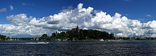
Alexandria is a town in the Thousand Islands region of the U.S. state of New York, within Jefferson County. The town's population was 3,741 at the 2020 United States Census. The town is named after Alexander LeRay, the son of an early developer. The village of Alexandria Bay is within the town.

Henderson is a town in Jefferson County, New York, United States. The population was 1,360 at the 2010 census. The town is named after William Henderson, the original European-American land owner.

<span class="mw-page-title-main">Hamlin, New York</span> Town in New York, United States

Hamlin is a town in Monroe County, New York, United States. The population was 8,725 at the 2020 census.

<span class="mw-page-title-main">Florida, Montgomery County, New York</span> Town in New York, United States

Florida is a town south of the Mohawk River in Montgomery County, New York, United States. The population was 2,696 in the 2010 United States Census. The town was named after the state of Florida. It is located in the eastern end of Montgomery County and is south of the City of Amsterdam, which it borders.

<span class="mw-page-title-main">Porter, New York</span> Town in New York, United States

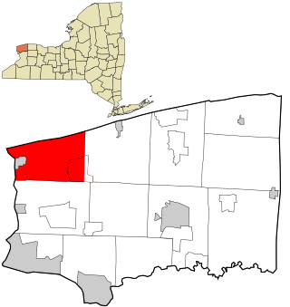
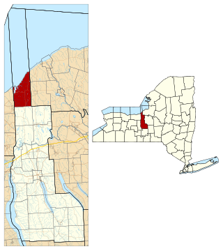
Porter is a town in Niagara County, New York, United States. The population was 6,771 at the 2010 census. The town was named after Judge Augustus Porter.

<span class="mw-page-title-main">Springfield, New York</span> Town in New York, United States

Springfield is a town in Otsego County, New York, United States. The population was 1,358 at the 2010 census.

Tioga is a town in Tioga County, New York, United States. The population was 4,455 at the 2020 census. The town is in the southwestern part of the county and lies between Elmira and Binghamton. Tioga is situated in the Southern Tier District of New York.

<span class="mw-page-title-main">New Berlin, New York</span> Town in New York, United States

New Berlin is a town in Chenango County, central New York, United States. The population was 2,682 at the 2010 census. The town contains the village of New Berlin. The town is at the eastern border of the county and is northeast of Norwich.

Cape Vincent is a town in Jefferson County, New York, United States. The population was 2,765 at the 2020 census.

<span class="mw-page-title-main">Clayton, New York</span> Town in New York, United States

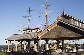
Clayton is a town in Jefferson County, New York, United States. The population was 5,153 at the 2010 census. The town is named after John M. Clayton, a federal political leader from Delaware.

Ellisburg is a village in Jefferson County, New York, United States. The population was 244 at the 2010 census. The village is named after two brothers who were the original landowners. It is located near the middle of the town of Ellisburg and is southwest of Watertown.

Livonia is a town in Livingston County, New York, United States. As of the 2010 census, the town population was 7,809. The town contains a village also named Livonia. The town is on the eastern border of the county.

<span class="mw-page-title-main">Amsterdam (town), New York</span> Town in New York, United States

Amsterdam is a town in Montgomery County, New York, United States. The population was 5,566 at the 2010 census. The town is named after Amsterdam, the capital of the Netherlands.

<span class="mw-page-title-main">Sandy Creek, New York</span> Town in New York, United States

Sandy Creek is a town in Oswego County, New York, United States. The population was 3,939 at the time of the 2010 census. The name is derived from a creek in the area.

<span class="mw-page-title-main">New York State Route 193</span> State highway in Jefferson County, New York, US

New York State Route 193 (NY 193) is a short state highway located entirely within the town of Ellisburg in the southwest part of Jefferson County in the North Country of New York in the United States. The western terminus of NY 193 is at an intersection with NY 3 at Southwick Beach State Park, just east of Lake Ontario. Its eastern terminus is at a junction with U.S. Route 11 (US 11) in Pierrepont Manor, just east of Interstate 81 (I-81) and north of Mannsville.

<span class="mw-page-title-main">New York State Route 289</span> State highway in Jefferson County, New York, US

New York State Route 289 (NY 289) is a north–south state highway in Jefferson County, New York, in the United States. The southern terminus of the route is at NY 193 in the village of Ellisburg near the center of the town of Ellisburg. Its northern terminus is at NY 178 in the extreme southwestern corner of the town of Adams.

<span class="mw-page-title-main">Black Pond Wildlife Management Area</span> New York state wildlife management area

Black Pond Wildlife Management Area is a 526-acre (213 ha) New York State Wildlife Management Area (WMA) that lies on the eastern shore of Lake Ontario, and at the northern limit of an unusual region of sandy barrier beaches and lagoons. Much of the barrier beach in Black Pond WMA has forested sand dunes that are about 60 feet (18 m) high; these are the highest sand dunes in the northeast United States excepting Cape Cod. Immediately north of the WMA is the 360-acre (150 ha) El Dorado Beach Preserve, which is a bird refuge owned by The Nature Conservancy. North of the outlet from Black Pond to Lake Ontario, the shoreline is a weathered, flat bedrock shelf that is "calcareous" instead of sandy.

Belleville is a hamlet and census-designated place (CDP) in the town of Ellisburg, Jefferson County, New York, United States. The population was 226 at the 2010 census.

References

  1. 1 2 "2020 U.S. Gazetteer Files". United States Census Bureau. Retrieved March 7, 2024.
  2. 1 2 "Profile of General Population and Housing Characteristics: 2020 Demographic Profile Data (DP-1): Ellisburg town, Jefferson County, New York". United States Census Bureau . Retrieved March 7, 2024.
  3. EDGAR C. EMERSON, ed. (1898). HISTORY of ELLISBURGH, NY. Boston, MA: THE BOSTON HISTORY COMPANY.{{cite book}}: |work= ignored (help)[ permanent dead link ]
  4. "Municipal Structures" Archived June 10, 2011, at the Wayback Machine , Office of the State Comptroller
  5. "Census of Population and Housing". Census.gov. Retrieved June 4, 2015.
  6. "U.S. Census website". United States Census Bureau . Retrieved January 31, 2008.
  7. "National Register of Historic Places Listings". Weekly List of Actions Taken on Properties: 1/03/12 through 1/06/12. National Park Service. January 13, 2012.