New York State Wildlife Management Areas

Last updated
Stream and forest at Happy Valley Wildlife Management Area in Oswego County, New York. Happy Valley WMA (New York) July 2009.JPG
Stream and forest at Happy Valley Wildlife Management Area in Oswego County, New York.
View of Lakeview Pond within Lakeview Wildlife Management Area Lakeview Pond NY.jpg
View of Lakeview Pond within Lakeview Wildlife Management Area

New York State Wildlife Management Areas (WMAs) are conservation areas managed by the New York State Department of Environmental Conservation (NYSDEC) primarily for the benefit of wildlife, and used extensively by the public for hunting, fishing, and trapping. As of 2016, the NYSDEC owns and maintains 113 WMAs, with a total area of approximately 197,000 acres (308 sq mi; 800 km2). [1] [2] The Wildlife Management Areas program is administered by the Division of Fish, Wildlife and Marine Resources of the NYSDEC. [1]

Contents

History

The first source of funding for New York's Wildlife Management Areas was the Conservation Fund of the Division, which was begun in 1925. It accumulates hunting, fishing, and trapping license fees and other miscellaneous fees and fines collected by the Division. [3] In the 1930s, the federal Resettlement Administration bought marginal and worn-out farmland and later donated it to the state for wildlife management purposes. The Pittman–Robertson Federal Aid in Wildlife Restoration Act of 1937 places an excise tax on guns and ammunition, of which 10% is returned to the states to fund restoration and management efforts for wildlife including purchase of habitat. New York State Bond Acts in 1960, 1972 and 1986 have also helped fund the WMA system.

Some of the WMAs occupy land that is environmentally sensitive. Thus the Lakeview Wildlife Management Area has been declared the Lakeview Marsh and Barrier Beach National Natural Landmark , and was cited in 1973 as, "One of the best and most extensive marshlands that lie in protected bays and behind barrier beaches along eastern Lake Ontario." [4]

List of New York state wildlife management areas

NameCounty or counties [5] Area [6] Notes
Alder Bottom Chautauqua 818 acres (3.31 km2)
Allegheny Reservoir Cattaraugus 1,100 acres (4.5 km2)
Ashland Flats Jefferson 2,037 acres (8.24 km2)
Ausable Marsh Clinton 576 acres (2.33 km2)
Bashakill Sullivan 2,213 acres (8.96 km2)
Baxtertown Woods Dutchess 250 acres (1.0 km2)
Bear Spring Mountain Delaware 7,186 acres (29.08 km2)
Black Pond Jefferson 526 acres (2.13 km2)Part of the "Eastern Lake Ontario Barrier Beach and Wetland Complex" New York Natural Heritage Area. [7]
Bog Brook Putnam 132 acres (0.53 km2)
Braddock Bay Monroe 2,402 acres (9.72 km2)
Canadaway Creek Chautauqua 2,080 acres (8.4 km2)
Canoga Marsh Seneca 104 acres (0.42 km2) [8] Protects marshland along the western shore of Cayuga Lake. [8]
Capital District Rensselaer 4,153 acres (16.81 km2)
Carters Pond Washington 446 acres (1.80 km2)
Carlton Hill Wyoming 2,484 acres (10.05 km2)
Catharine Creek Schuyler 660 acres (2.7 km2)
Cayuga Lake Seneca 225 acres (0.91 km2)
Chautauqua Lake Chautauqua 123 acres (0.50 km2)
Cherry Island Orange 14 acres (0.057 km2) [9] Protects an island within the upper Delaware River. [9]
Cicero Swamp Onondaga 4,947 acres (20.02 km2)
Clay Pond Chautauqua 182 acres (0.74 km2)
Cold Brook Steuben 125 acres (0.51 km2) [10]
Collins Landing Jefferson 44 acres (0.18 km2)
Conesus Inlet Livingston 1,220 acres (4.9 km2)
Conewango Swamp Cattaraugus 900 acres (3.6 km2)
Connecticut Hill Schuyler, Tompkins 11,161 acres (45.17 km2)
Cranberry Creek Jefferson 13 acres (0.053 km2) [11]
Cranberry Mountain Putnam 467 acres (1.89 km2)
Cross Lake Islands Cayuga, Onondaga 27 acres (0.11 km2)
Crumhorn Mountain Otsego
Currans Road Pond Suffolk
Curtiss Gale Oswego 47 acres (0.19 km2)
Deer Creek Marsh Oswego 1,770 acres (7.2 km2)Part of the "Eastern Lake Ontario Barrier Beach and Wetland Complex" New York Natural Heritage Area. [7]
Dexter Marsh Jefferson 1,339 acres (5.42 km2)
East Bay Washington 38 acres (0.15 km2)
Erwin Steuben 2,500 acres (10 km2)
Fish Creek St. Lawrence 4,438 acres (17.96 km2)
Franklinton Vlaie Schoharie 185 acres (0.75 km2)
French Creek Jefferson 2,265 acres (9.17 km2)
Frenchman's Island Onondaga, Oswego 28 acres (0.11 km2) [12] Formerly operated as the undeveloped Frenchman Island State Park. Transferred to NYSDEC in 2011, and now part of Three Mile Bay WMA. [12] [13]
Galen Wayne 712 acres (2.88 km2)
Genesee Valley Allegany 717 acres (2.90 km2)
Great Baehre Swamp Erie 271 acres (1.10 km2)
Great Swamp Putnam 444 acres (1.80 km2)
Great Vly Greene, Ulster 184 acres (0.74 km2)
Hamlin Marsh Onondaga 1,689 acres (6.84 km2)
Hampton Brook Woods Erie 61 acres (0.25 km2)
Hanging Bog Allegany 4,571 acres (18.50 km2)
Happy Valley Oswego 8,895 acres (36.00 km2)
Hartland Swamp Niagara 385 acres (1.56 km2)
Hartson Swamp Chautauqua 98 acres (0.40 km2)
Helmer Creek Steuben 126 acres (0.51 km2) [14]
High Tor Ontario, Yates 6,200 acres (25 km2)
Honeoye Creek Ontario 717 acres (2.90 km2)
Honeoye Inlet Ontario 1,981 acres (8.02 km2) [15]
Honeyville Jefferson 111 acres (0.45 km2)
Hooker Mountain Otsego
Indian River Jefferson 968 acres (3.92 km2)
Jacquins Pond Chautauqua 30 acres (0.12 km2)
John White Genesee 339 acres (1.37 km2) [16] Formerly managed by New York State as the "John White Memorial Game Farm" between 1945 and 2000 for the purpose of raising pheasants for release on public hunting lands. [16]
Kabob Chautauqua 38 acres (0.15 km2)
Keeney Swamp Allegany 708 acres (2.87 km2)
Kings Bay Clinton 653 acres (2.64 km2)
Lake Alice Clinton 1,468 acres (5.94 km2)
Lake Ontario Islands Jefferson, St. Lawrence 64 acres (0.26 km2) [17] Protects the 43-acre (17 ha) Little Galloo Island, the one-acre (0.40 ha) Gull Island, and a 20-acre (8.1 ha) portion of Galloo Island. [17]
Lake Shore Marshes Wayne 6,130 acres (24.8 km2)
Lakeview Jefferson 3,461 acres (14.01 km2)Part of the "Eastern Lake Ontario Barrier Beach and Wetland Complex" New York Natural Heritage Area. [7]
Lewis Preserve Clinton 1,356 acres (5.49 km2)
Little John Oswego 7,918 acres (32.04 km2)
Louise E. Keir Albany 119 acres (0.48 km2)
Margaret Burke Albany 246 acres (1.00 km2)
Mongaup Valley Sullivan 11,855 acres (47.98 km2)
Monty's Bay Clinton 287 acres (1.16 km2)
Motor Island Erie 6 acres (0.024 km2)
Northern Montezuma Seneca, Wayne, Cayuga 7,500 acres (30 km2)
Oak Orchard Genesee 2,545 acres (10.30 km2)
Oriskany Flats Oneida 750 acres (3.0 km2)
Otis Pike Preserve Suffolk 4,000 acres (16 km2)
Parcel 45 Saratoga 59 acres (0.24 km2)
Partridge Run Albany 4,594 acres (18.59 km2)
Pauline Murdock Essex 68 acres (0.28 km2)
Perch River Jefferson 7,862 acres (31.82 km2)
Pharsalia Chenango 4,694 acres (19.00 km2)
Plantation Island Herkimer 300 acres (1.2 km2)
Point Peninsula Jefferson 1,054 acres (4.27 km2)
Putts Creek Essex 114 acres (0.46 km2)
Rattlesnake Hill Livingston, Allegany 5,150 acres (20.8 km2)
Roger's Island Columbia 281 acres (1.14 km2)
Rome Oneida 436 acres (1.76 km2)
Saratoga Sand Plains Saratoga 735 acres (2.97 km2) [18]
Silver Lake Wyoming 10 acres (0.040 km2)
Spicer Creek Erie 34 acres (0.14 km2)
Stid Hill Ontario 847 acres (3.43 km2)
Stockport Columbia 357 acres (1.44 km2) [19]
Three Mile Bay Oswego 3,495 acres (14.14 km2)Incorporates Frenchman's Island. [13]
Three Rivers Onondaga 3,586 acres (14.51 km2)
Tillman Road Erie 230 acres (0.93 km2)
Tioughnioga Madison 3,803 acres (15.39 km2)
Tivoli Bays Dutchess 1,722 acres (6.97 km2)Designated as a "New York Natural Heritage Area" in 2007. [20]
Tonawanda Genesee, Orleans, Niagara 5,600 acres (23 km2)
Tug Hill Lewis 5,114 acres (20.70 km2)
Upper and Lower Lakes St. Lawrence 8,782 acres (35.54 km2)
Utica Marsh Oneida 213 acres (0.86 km2)
Victory Mills Saratoga 47 acres (0.19 km2) [21]
Vinegar Hill Greene 394 acres (1.59 km2)
Waneta-Lamoka Schuyler 157 acres (0.64 km2) [10]
Watt's Flats Chautauqua 1,382 acres (5.59 km2)
West Cameron Steuben 170 acres (0.69 km2)
Whitney Point Broome, Cortland 4,645 acres (18.80 km2)
Wickham Marsh Essex 862 acres (3.49 km2)
Willard Seneca 158 acres (0.64 km2)
Wilson Hill St. Lawrence 3,441 acres (13.93 km2)
Wolf Hollow Delaware 52 acres (0.21 km2)
Young's Island Suffolk

See also

Related Research Articles

<span class="mw-page-title-main">Southwick Beach State Park</span> State park in Jefferson County, New York

Southwick Beach State Park is a New York State park that lies along an unusual stretch of sandy beach on the eastern shore of Lake Ontario. The park is 464 acres (188 ha) in size with a 3,500 foot (1,100 m) length of beach, and is visited annually by about 100,000 people. Immediately to the south is the Lakeview Wildlife Management Area, which extends the publicly accessible beach by several miles. They are in the Town of Ellisburg in Jefferson County, New York south of the lakeside community of Jefferson Park.

Cherry Plain State Park is a 175-acre (0.71 km2) state park located in Rensselaer County, New York in the United States. The park is located in Cherry Plain at the southwest part of the Town of Berlin, near the Massachusetts border. Outdoor recreational opportunities are also available within the Capital District Wildlife Management Area, a 4,153-acre (16.81 km2) conservation area that nearly surrounds the park.

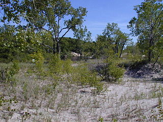
Rome Sand Plains is a 15,000-acre (61 km2) pine barrens about five miles (8.0 km) west of the city center of Rome in Oneida County in central New York. It consists of a mosaic of sand dunes rising about 50 feet (15 m) above low peat bogs that lie between the dunes. The barrens are covered with mixed northern hardwood forests, meadows, and wetlands. About 4,000 acres (16 km2) are protected in conservation preserves. Pine barrens are typical of seacoasts; the Rome Sand Plains is one of only a handful of inland pine barrens remaining in the United States. A second inland pine barrens, the Albany Pine Bush, is also found in New York, located north and west of state's capital Albany.

Bowman Lake State Park is a 653-acre (2.64 km2) state park located in Chenango County, New York. The park is located in the Town of McDonough, north of the community of East McDonough.

<span class="mw-page-title-main">Braddock Bay</span> Body of water

Braddock Bay, sometimes improperly referred to as Braddock's Bay, is a small bay of Lake Ontario located in Monroe County northwest of Rochester, New York in the United States. Braddock Bay is renowned for being an excellent bird-watching location, as raptors and other birds congregate there when migrating north in spring.

<span class="mw-page-title-main">Sandy Island Beach State Park</span> New York State park

Sandy Island Beach State Park is a New York State park on the eastern shore of Lake Ontario. Its highlight is a 1,500-foot (460 m) natural sandy beach. The park is near the southern end of a notable 17-mile (27 km) length of sandy shoreline, coastal dunes, and wetlands ; a 1959 study noted that "The eastern end of Lake Ontario contains not only the finest beaches on the entire lake but also the finest wildlife habitat."

<span class="mw-page-title-main">New York State Department of Environmental Conservation</span> New Yorks state-level environmental regulator

The New York State Department of Environmental Conservation is a department of New York state government. The department guides and regulates the conservation, improvement, and protection of New York's natural resources; manages Forest Preserve lands in the Adirondack and Catskill parks, state forest lands, and wildlife management areas; regulates sport fishing, hunting and trapping; and enforces the state's environmental laws and regulations. Its regulations are compiled in Title 6 of the New York Codes, Rules and Regulations. It was founded in 1970, replacing the Conservation Department. and is headed by Basil Seggos.

<span class="mw-page-title-main">Basha Kill Wildlife Management Area</span>

The Basha Kill Wildlife Management Area is a 2,213-acre (8.96 km2) conservation area consisting of wetlands and uplands along the Basher Kill in Sullivan County, New York.

The Oak Orchard Wildlife Management Area is an approximately 2,500-acre (10 km2) wildlife management area (WMA) located in western New York, United States. Most of this conservation area is in the northwest part of Genesee County, with a small northern portion in Orleans County.

The Tonawanda Wildlife Management Area is a 5,600-acre (23 km2) wildlife management area (WMA) located in western New York State. It is located primarily within Niagara County and Genesee County, with a small portion within Orleans County. It is managed by the New York State Department of Environmental Conservation.

The Hartland Swamp Wildlife Management Area is a 401-acre (1.62 km2) wildlife management area (WMA) located in western New York, US. Hartland Swamp WMA is located northeast of Lockport in the Town of Hartland in northeastern Niagara County. It is managed by the New York State Department of Environmental Conservation.

<span class="mw-page-title-main">Tillman Road Wildlife Management Area</span> Conservation area in New York State, U.S.

Tillman Road Wildlife Management Area is a 235-acre (0.95 km2) conservation area located within the Town of Clarence in Erie County, western New York. It is managed by the New York State Department of Environmental Conservation.

Great Baehre Swamp is a New York state wetland located inside the Town of Amherst in Erie County, New York, United States. The area is characterized as a silver maple-ash swamp of 270 acres (1.1 km2), much of which is protected by conservation areas owned by the town and New York State.

<span class="mw-page-title-main">Black Pond Wildlife Management Area</span>

Black Pond Wildlife Management Area is a 526-acre (213 ha) New York State Wildlife Management Area (WMA) that lies on the eastern shore of Lake Ontario, and at the northern limit of an unusual region of sandy barrier beaches and lagoons. Much of the barrier beach in Black Pond WMA has forested sand dunes that are about 60 feet (18 m) high; these are the highest sand dunes in the northeast United States excepting Cape Cod. Immediately north of the WMA is the 360-acre (150 ha) El Dorado Beach Preserve, which is a bird refuge owned by The Nature Conservancy. North of the outlet from Black Pond to Lake Ontario, the shoreline is a weathered, flat bedrock shelf that is "calcareous" instead of sandy.

<span class="mw-page-title-main">Deer Creek Marsh Wildlife Management Area</span>

Deer Creek Marsh Wildlife Management Area is an 1,195-acre (484 ha) New York State Wildlife Management Area (WMA) with a 4,500-foot (1,400 m) sandy beach on the eastern shore of Lake Ontario; it is in the Town of Richland in Oswego County, New York. Deer Creek Marsh lies at the southern limit of a 17-mile-long (27 km) region of sandy barrier beaches that protect coastal lagoons and marshes; the region is unusual geologically and is important as habitat for many species. Deer Creek Marsh WMA is part of the Eastern Lake Ontario Marshes Bird Conservation Area, along with Black Pond and Lakeview WMAs and the Sandy Pond Beach Unique Area. Some of the hiking and boating opportunities in the WMA are described in a brochure and a website created through the New York Sea Grant.

<span class="mw-page-title-main">Sandy Pond Beach Unique Area</span>

Sandy Pond Beach Unique Area is a 76-acre (31 ha) New York State conservation area located within the eastern Lake Ontario dunes. It lies at the north end of a spit of land dividing North Sandy Pond from Lake Ontario, and is about two miles (3.2 km) north of the developed portion of Sandy Island Beach State Park. There is no road access to the area, which can be most easily reached by boat. For this reason, local residents have long referred to the beach as "Boaters' Beach". It has been managed as part of Sandy Island Beach State Park since 2011.

<span class="mw-page-title-main">New York State Forests</span>

New York State Forests are administered by the Division of Lands and Forests of the New York State Department of Environmental Conservation (NYSDEC). New York State Forests include reforestation, multiple use, and unique areas; and state nature and historic preserves, with approximately 600,000 acres (2,400 km2) classified as reforestation areas and approximately 9,000 acres (36 km2) classified as multiple use lands. Land within the Adirondack Park or the Catskill Park is not included as part of the State Forest system.

Dexter Marsh is a 1,350-acre (5.5 km2) marsh located at the eastern end of Lake Ontario in Dexter, New York. It was declared a National Natural Landmark in May 1973.

<span class="mw-page-title-main">Charles E. Wheeler Wildlife Management Area</span>

Charles E. Wheeler Wildlife Management Area is a 625-acre (253 ha) brackish tidal marsh, nature preserve and hunting area owned by the state of Connecticut located in Devon (village), Milford, New Haven County, Connecticut.

References

Notes

  1. 1 2 "Habitat Management and Access on Wildlife Management Areas". New York State Department of Environmental Conservation. Retrieved 2016-04-09.
  2. "List of New York State Wildlife Management Areas". New York State Department of Environmental Conservation. Retrieved 2016-04-09.
  3. "Division of Fish, Wildlife and Marine Resources". New York State Department of Environmental Conservation. Retrieved 2010-02-06.
  4. "Lakeview Marsh and Barrier Beach". National Park Service. Retrieved 2007-07-31. Entry in registry of National Natural Landmarks.
  5. "Title 9, Chapter I, Subchapter A, Part 384: Listing of State Parks, Parkways, Recreation Facilities, State Land and Historic Sites (Facilities), DEC Facilities". Official Compilation of Codes, Rules and Regulations of the State of New York. WestlawNext. Retrieved June 30, 2016.
  6. Unless otherwise noted, acreages are sourced from individual pages listed at: "List of New York State Wildlife Management Areas". NYS Department of Environmental Conservation. Retrieved June 30, 2016.
  7. 1 2 3 "Natural Heritage Area Designation for Eastern Lake Ontario Barrier Beach and Wetland Complex". New York State Department of Environmental Conservation. Retrieved 2016-07-16.
  8. 1 2 Fayette-Varick Comprehensive Plan Commission (2005). Towns of Fayette and Varick Comprehensive Plan, Adopted 2005/2006 (PDF) (Report). Town of Fayette, NY. p. 26. Retrieved July 6, 2016.
  9. 1 2 Final Environmental Impact Statement for the River Management Plan: Upper Delaware National Scenic and Recreational River, Delaware, Sullivan, and Orange Counties, New York, Pike and Wayne Counties, Pennsylvania (Report). United States National Park Service. 1984. p. 123. Retrieved July 6, 2016.
  10. 1 2 Keuka Lowlands Unit Management Plan (PDF) (Report). NYS Department of Environmental Conservation. April 2012. p. 6. Retrieved July 9, 2016.
  11. "Cranberry Creek Wildlife Management Area". NYS Department of Environmental Conservation. Retrieved July 9, 2016.
  12. 1 2 "Land and Conservation Easement Acquisitions: Second Quarter 2011". NYS Department of Environmental Conservation. Archived from the original on February 25, 2015. Retrieved July 1, 2016.
  13. 1 2 "Three Mile Bay Wildlife Management Area Map". New York State Department of Environmental Conservation. Retrieved 2016-07-11.
  14. "Helmer Creek Wildlife Management Area". NYS Department of Environmental Conservation. Retrieved July 9, 2016.
  15. "Honeoye Inlet Wildlife Management Area". NYS Department of Environmental Conservation. Retrieved July 9, 2016.
  16. 1 2 Carroll, Thomas (2001). "History of the Wildlife Areas: Iroquois National Wildlife Refuge, Oak Orchard Wildlife Management Area, Tonawanda Wildlife Management Area, John White Wildlife Management Area". U.S. Fish & Wildlife Service. pp. 24–25. Retrieved July 9, 2016.
  17. 1 2 Lake Ontario Islands WMA Unit Management Plan (PDF) (Report). New York State Department of Environmental Conservation. February 2002. p. 1. Retrieved July 5, 2016.
  18. "DEC Adds 157 Acres to the Saratoga Sand Plains Wildlife Management Area". NYS Department of Environmental Conservation. April 22, 2015. Retrieved July 9, 2016.
  19. "Stockport Wildlife Management Area". NYS Department of Environmental Conservation. Retrieved July 9, 2016.
  20. "Tivoli Bays Wildlife Management Area". New York State Department of Environmental Conservation. Retrieved 2016-07-16.
  21. "Victory Mills Wildlife Management Area". NYS Department of Environmental Conservation. Retrieved July 9, 2016.

Further reading