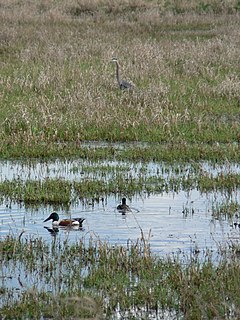
Ridgefield National Wildlife Refuge is a wildlife preserve, one of the national wildlife refuges operated by the United States Fish and Wildlife Service, located in the westernmost part of Clark County, Washington. The refuge protects more than 5,200 acres (2,100 ha) of marshes, grasslands, and woodlands. The refuge was established in 1965, in response to a need to establish vital winter habitat for wintering waterfowl with an emphasis on the dusky Canada goose whose nesting areas in Alaska were severely impacted by the violent earthquake of 1964. Ridgefield NWR is part of the Ridgefield National Wildlife Refuge Complex, headquartered in Ridgefield, Washington, which oversees the management of four refuges in the southwestern part of the state: Ridgefield, and three refuges in the Columbia River Gorge: Franz Lake, Pierce, and Steigerwald Lake.

Don Edwards San Francisco Bay National Wildlife Refuge (DESFBNWR) is a United States National Wildlife Refuge located in the southern part of San Francisco Bay, California. The Refuge headquarters and visitor center is located in the Baylands district of Fremont, next to Coyote Hills Regional Park, in Alameda County. The visitor center is on Marshlands Rd, off Thornton Ave.

Kīlauea Point National Wildlife Refuge is a National Wildlife Refuge on the northwest coast of the island of Kauaʻi in Hawaiʻi.
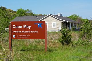
The Cape May National Wildlife Refuge is a protected area on the Cape May Peninsula in Cape May County, New Jersey. It is part of the National Wildlife Refuge System and managed by the United States Fish and Wildlife Service. Established in January 1989 with 90 acres (0.36 km2) acquired from the Nature Conservancy, it has since grown to more than 11,000 acres (45 km2) in size, and plans call for its further expansion to more than 21,200 acres (86 km2). It comprises three distinct and non-contiguous units: the Delaware Bay Division, the Great Cedar Swamp Division and the Two Mile Beach Unit. Located in the Middle Atlantic coastal forests ecoregion, the cape provides habitat for large numbers of migratory birds.

The Stewart B. McKinney National Wildlife Refuge is a 950-acre (384.5 ha) National Wildlife Refuge in ten units across the U.S. state of Connecticut. Located in the Atlantic Flyway, the refuge spans 70 miles (110 km) of Connecticut coastline and provides important resting, feeding, and nesting habitat for many species of wading birds, shorebirds, songbirds and terns, including the endangered roseate tern. Adjacent waters serve as wintering habitat for brant, scoters, American black duck, and other waterfowl. Overall, the refuge encompasses over 900 acres (364.2 ha) of barrier beach, intertidal wetland and fragile island habitats.

The Rachel Carson National Wildlife Refuge is a 9,125-acre (37 km2) National Wildlife Refuge made up of several parcels of land along 50 miles (80 km) of Maine's southern coast. Created in 1966, it is named for environmentalist and author Rachel Carson, whose book Silent Spring raised public awareness of the effects of DDT on migratory songbirds, and of other environmental issues.
The Oregon Coast National Wildlife Refuge Complex consists of six National Wildlife Refuges along the Oregon Coast. It provides wilderness protection to thousands of small islands, rocks, reefs, headlands, marshes, and bays totaling 371 acres spanning 320 miles (515 km) of Oregon's coastline. The areas are all managed by the United States Fish and Wildlife Service.

Willapa National Wildlife Refuge is a National Wildlife Refuge located on the shores of Willapa Bay in Washington, United States. It comprises 11,000 acres (45 km2) of sand dunes, sand beaches, mudflats, grasslands, saltwater and freshwater marshes, and coniferous forest. The refuge includes Long Island with stands of old growth Western red cedar and hemlock.

The Chincoteague National Wildlife Refuge is a 14,000-acre (57 km2) wildlife preserve operated by the U.S. Fish & Wildlife Service. It is primarily located on the Virginia half of Assateague Island with portions located on the Maryland side of the island, as well as Morris Island and Wildcat Marsh. The refuge contains a large variety of wildlife animals and birds, including the Chincoteague Pony. The purpose of the refuge is to maintain, regulate and preserve animal and plant species as well as their habitats for present and future generations.

The Nomans Land Island Wildlife Refuge is a United States National Wildlife Refuge located on Nomans Land, a 640-acre (2.6 km2) island off the coast of Martha's Vineyard in Massachusetts. It is part of the town of Chilmark, in Dukes County. The Island is 1.6 miles (2.6 km) long east to west, and about 1 mile (1.6 km) north to south. Nomans Land Island was used for aerial gunnery by the U.S. Navy from 1942 to 1996. The United States Fish and Wildlife Service has managed an "overlay" refuge on the Eastern third of the Island under a Joint Management Agreement between the Department of the Interior and Department of the Navy since 1975. Following an extensive surface clearance of ordnance in 1997 and 1998, the Island was transferred to the United States Fish and Wildlife Service to become Nomans Land Island National Wildlife Refuge. It was established ". .. for use as an inviolate sanctuary, or for any other management purpose, for migratory birds" under the Migratory Bird Conservation Act.
The Wertheim National Wildlife Refuge is located on the south shore of Long Island and is one of the undeveloped estuary systems on Long Island. In 1947, Maurice Wertheim donated 2,000 acres (8.1 km2) on eastern Long Island to the United States government; the donated land subsequently became the Wertheim National Wildlife Refuge. The refuge's purpose is to protect the Carmans River Estuary for migratory birds. Wertheim hosts a variety of habitats including oak-pine woodlands, grasslands, and fresh, brackish and salt water wetlands. These habitats attract and support many types of wildlife including white-tailed deer, osprey, muskrat, fox, turtles, frogs and fish. The refuge also serves as a haven for waterfowl, shorebirds, raptors, and songbirds.
The Delta National Wildlife Refuge is located 10 miles (16 km) east of Venice, Louisiana along the Mississippi River. The area formed when a breach in the natural levee of the Mississippi River occurred in 1862 approximately 100 miles (160 km) below New Orleans, Louisiana. The 48,000-acre (190 km2) refuge was purchased in 1935 with the primary purpose to provide sanctuary and habitat to wintering waterfowl. Access is by boat only.
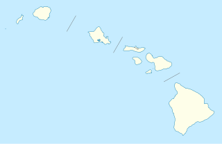
Kakahaiʻa National Wildlife Refuge (NWR) was established in 1977 to permanently protect wetland habitat for endangered endemic waterbirds and wintering migratory wetland birds and to maintain the structural integrity of an ancient Hawaiian fishpond.

Parker River National Wildlife Refuge was established in 1942 primarily to provide feeding, resting, and nesting habitats for migratory birds. Located along the Atlantic Flyway, the refuge is of vital stopover significance to waterfowl, shorebirds, and songbirds during migratory periods.
The Supawna Meadows National Wildlife Refuge is part of the Cape May National Wildlife Refuge. A component of the Delaware River estuary in Salem County, New Jersey, it is just north of the Salem River and south of Pennsville.

The Elizabeth A. Morton National Wildlife Refuge is a 187-acre (76 ha) National Wildlife Refuge in Noyack, New York. Much of the refuge is situated on a peninsula surrounded by Noyack and Little Peconic bays. The refuge is managed by the United States Fish and Wildlife Service as part of the Long Island National Wildlife Refuge Complex.
Seatuck National Wildlife Refuge is located in the hamlet of Islip, New York, on the south shore of Long Island. It is managed by the U.S. Fish and Wildlife Service as part of the Long Island National Wildlife Refuge Complex. The refuge consists of 196 acres (0.79 km2) bordering the Great South Bay, separated from the Atlantic Ocean only by Fire Island. Situated in a heavily developed urban area along Champlin Creek, the refuge is an oasis for many species of migratory birds and waterfowl.

The Target Rock National Wildlife Refuge is located just east of the village of Lloyd Harbor, New York, on the north shore of Long Island, 25 miles (40 km) east of New York City. It is managed by the U.S. Fish and Wildlife Service as part of the Long Island National Wildlife Refuge Complex.

Humboldt Bay National Wildlife Refuge is located on Humboldt Bay, on the California North Coast near the cities of Eureka and Arcata. The refuge exists primarily to protect and enhance wetland habitats for migratory water birds using the bay area, including tens of thousands of shorebirds, ducks, geese, swans, and the black brant. Humboldt Bay National Wildlife Refuge, along with other public and private lands around Humboldt Bay, is one of the key stopovers for the millions of migratory birds that rely on the Pacific Flyway. More than 200 bird species, including 80 kinds of water birds and four endangered species, regularly feed, rest, or nest on the refuge or other areas around the bay.
Long Island National Wildlife Refuge Complex is a National Wildlife Refuge complex in the state of New York. All of the component refuges are located on Long Island.


