Darien Lakes State Park is a 1,845-acre (7.47 km2) state park in western Genesee County, New York, near Darien Center. The park entrance is on Harlow Road, north of U.S. Route 20.
Hudson River Islands State Park is a 235-acre (0.95 km2) state park in New York. The park is located on the Hudson River in Greene and Columbia counties.

The New York State Office of Parks, Recreation and Historic Preservation is a state agency within the New York State Executive Department charged with the operation of state parks and historic sites within the U.S. state of New York. As of 2014, the NYS OPRHP manages nearly 335,000 acres of public lands and facilities, including 180 state parks and 35 historic sites, that are visited by over 78 million visitors each year.
Cherry Plain State Park is a 175-acre (0.71 km2) state park located in Rensselaer County, New York in the United States. The park is located in Cherry Plain at the southwest part of the Town of Berlin, near the Massachusetts border. Outdoor recreational opportunities are also available within the Capital District Wildlife Management Area, a 4,153-acre (16.81 km2) conservation area that nearly surrounds the park.
Bowman Lake State Park is a 653-acre (2.64 km2) state park located in Chenango County, New York. The park is located in the Town of McDonough, north of the community of East McDonough.
Sterling Forest State Park is a 21,938-acre (88.78 km2) state park located in the Ramapo Mountains in Orange County, New York. Established in 1998, it is among the larger additions to the New York state park system in the last 50 years.

New York's Forest Preserve, comprises almost all the lands owned by the state of New York within the Adirondack and Catskill parks. It is managed by the state Department of Environmental Conservation (DEC).
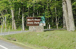
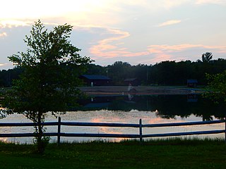
Max V. Shaul State Park is a 70-acre (0.28 km2) state park in Schoharie County, New York, United States. The park is located in Schoharie Valley between Breakabeen and Fultonham in the Town of Fulton, within sight of Vroman's Nose.

The New York State Department of Environmental Conservation is a department of New York state government. The department guides and regulates the conservation, improvement, and protection of New York's natural resources; manages Forest Preserve lands in the Adirondack and Catskill parks, state forest lands, and wildlife management areas; regulates sport fishing, hunting and trapping; and enforces the state's environmental laws and regulations. Its regulations are compiled in Title 6 of the New York Codes, Rules and Regulations. It was founded in 1970, replacing the Conservation Department, and is headed by Basil Seggos.

Caumsett State Historic Park Preserve is a state park on Lloyd Neck, a peninsula extending into the Long Island Sound, in the Village of Lloyd Harbor, New York. It is operated by the New York State Office of Parks, Recreation and Historic Preservation.
The Debar Mountain Wild Forest is a 83,405-acre (337.53 km2) tract designated as Wild Forest by the New York State Department of Environmental Conservation in the northeastern Adirondack Park, just north of Paul Smiths, in Franklin County. The area includes 61,500 acres (249 km2) of state land and 60,600 acres (245 km2) of conservation easement land. The area is served by state routes NY-3, NY-30 and NY-458.

The Moose River Plains Wild Forest is a 64,322-acre tract in the Adirondack Park in Hamilton and Herkimer counties in the state of New York in the United States of America; it is designated as Wild Forest by the New York State Department of Environmental Conservation.

New York State Wildlife Management Areas (WMAs) are conservation areas managed by the New York State Department of Environmental Conservation (NYSDEC) primarily for the benefit of wildlife, and used extensively by the public for hunting, fishing, and trapping. As of 2016, the NYSDEC owns and maintains 113 WMAs, with a total area of approximately 197,000 acres. The Wildlife Management Areas program is administered by the Division of Fish, Wildlife and Marine Resources of the NYSDEC.

Sandy Pond Beach Unique Area is a 76-acre (31 ha) New York State conservation area located within the eastern Lake Ontario dunes. It lies at the north end of a spit of land dividing North Sandy Pond from Lake Ontario, and is about two miles (3.2 km) north of the developed portion of Sandy Island Beach State Park. There is no road access to the area, which can be most easily reached by boat. For this reason, local residents have long referred to the beach as "Boaters' Beach". It has been managed as part of Sandy Island Beach State Park since 2011.

New York State Forests are public lands administered by the Division of Lands and Forests of the New York State Department of Environmental Conservation (NYSDEC). New York State Forests are designated as reforestation, multiple use, and unique areas; and state nature and historic preserves, with approximately 600,000 acres (2,400 km2) classified as reforestation areas and approximately 9,000 acres (36 km2) classified as multiple use lands. Land within the Adirondack Park or the Catskill Park is not included as part of the State Forest system.

Clarksburg State Park is a 368-acre (149 ha) Massachusetts state park located in the town of Clarksburg. The park is made up of unspoiled northern hardwood forest, with views of the Hoosac Range, Mount Greylock and the Green Mountains. It is managed by the Department of Conservation and Recreation.
Svend O. Heiberg Memorial Forest is a 3,800-acre (1,500-hectare) research forest located in parts of Onondaga and Cortland counties, and within the towns of Truxton, Preble, Fabius, and Tully in New York State. Originally Tully Experimental Forest, the forest was renamed in 1965 after Svend O. Heiberg, former Associate Dean of Graduate Studies at the New York State College of Forestry at Syracuse University, in Syracuse, New York.

The Labrador Hollow Unique Area is a 1,474-acre (5.97 km2) conservation area located in Cortland and Onondaga counties, New York, and was the first property to be designated as a Unique Area by New York. The area is located adjacent to and between Kettlebail State Forest and Morgan Hill State Forest, and is managed by the New York State Department of Environmental Conservation. The area is open to the public and includes Labrador Pond and Tinker Falls.
