New York State Forests

Last updated
An old logging road through a pine plantation at Morgan Hill State Forest in Onondaga County, New York. Morgan Hill State Forest.JPG
An old logging road through a pine plantation at Morgan Hill State Forest in Onondaga County, New York.

New York State Forests are public lands administered by the Division of Lands and Forests of the New York State Department of Environmental Conservation (NYSDEC). New York State Forests are designated as reforestation, multiple use, and unique areas; and state nature and historic preserves, with approximately 600,000 acres (2,400 km2) classified as reforestation areas and approximately 9,000 acres (36 km2) classified as multiple use lands. Land within the Adirondack Park or the Catskill Park is not included as part of the State Forest system.

Contents

State Forest management

The purpose of state forest management in New York is to promote forest conservation, improve ecosystem health and biodiversity, provide recreational opportunities, and derive economic benefits from forests by employing sustainable management practices. [1] As of 2016, more than 787,000 acres (3,180 km2; 1,230 sq mi) of forests are managed by the NYSDEC; this includes areas designated as state forests, reforestation areas, multiple-use areas, and unique areas, but does not include forest preserve lands within Adirondack Park and Catskill Park. [2]

Permissible activities on New York state forest lands include hunting, trapping, fishing, hiking, snowshoeing, cross-county skiing, horseback riding, snowmobiling, and camping, although some properties prohibit some of these activities. [2] Motorized vehicle use is prohibited except for on specified roads and trails. Camping for longer than three consecutive nights, or in groups of ten or greater people, requires a free permit issued by the NYSDEC; in addition, campsites must be located at least 150 feet (46 m) away from roads, trails, and streams unless previously established by the NYSDEC. [3]

Classifications

Entrance sign for the East Otto State Forest in Cattaraugus County. New York State Forest sign - East Otto State Forest.jpg
Entrance sign for the East Otto State Forest in Cattaraugus County.

There are four categories of state forest lands established under New York State law; their descriptions are below. [4]

Reforestation areas

Lands obtained for reforestation and maintained for watershed protection, the production of timber and other forest products, and for recreation and related purposes. These areas must have at least 500 acres (200 ha) of contiguous lands that shall be forever devoted to the planting, growth and harvesting of such trees as shall be reforested.

Multiple use areas

Funded by the park and recreation land acquisition bond acts of 1960 and 1962 to provide opportunities for outdoor recreation, including public camping, fishing, hunting, boating, winter sports. Wherever possible, the multiple-use-areas should also serve multiple purposes involving the conservation and development of natural resources, including the preservation of scenic areas, watershed protection, forestry and reforestation.

Unique areas

Lands of special natural beauty, wilderness character, geological, ecological or historical significance; the unique areas may include lands within a forest preserve county outside the Adirondack and Catskill Parks.

State Nature and Historic Preserve

Lands dedicated to the State Nature and Historic Preserve (as referred to in Section 4 of Article XIV of the State Constitution) are declared to be put to their highest, best and most important use for one or more of the following purposes:

  1. As natural communities for maintaining plants, animals and natural communities;
  2. As reservoirs of natural materials and ecological processes that contribute to the state's biological diversity;
  3. As field laboratories for scientific research and education in the natural sciences, including the fields of biology, conservation, ecology, natural history and paleontology; and
  4. As places of natural and historical interest and beauty which provide the public with passive recreational opportunities including, where appropriate, fishing, hunting and trapping, or commercial fishing opportunities that are compatible with protecting the ecological significance, historic features and natural character of the area. [4]

List of New York State Forests

The following sortable table includes several classifications of state forests in New York. Those labelled as "State Forests" are managed for a variety of goals; many are reforestation areas that are intended for timber production and watershed protection, in addition to providing space for outdoor recreation. "Multiple Use Areas" are managed primarily to provide space for outdoor recreation, with the additional purpose of land conservation and protection. "Unique Areas" are intended to protect areas with significant geological, ecological, aesthetic, or historical features. [4]

ForestCounty [5] [6] ClassificationArea [7] Notes
Albert J. Woodford Oneida State Forest
Allen Lake Allegany State Forest2,421 acres (9.80 km2)
Altmar Oswego State Forest959 acres (3.88 km2)
Ambler Chenango State Forest629 acres (2.55 km2)
Andersen Hill Tioga State Forest554 acres (2.24 km2)
Arctic-China Delaware State Forest2,959 acres (11.97 km2) [8]
Armlin Hill Schoharie State ForestManaged as part of the 2,400-acre (9.7 km2) Keyserkill State Forest Complex, which also includes Keyserkill State Forest and Gates Hill State Forest. [9]
Arnold Lake Otsego State Forest1,266 acres (5.12 km2)
Ashland Pinnacle Schoharie, Greene State Forest948 acres (3.84 km2)
Baker School House Cortland State Forest1,277 acres (5.17 km2) [10]
Bald Mountain Allegany State Forest764 acres (3.09 km2)
Balsam Lewis State Forest559 acres (2.26 km2)
Balsam Swamp Chenango State Forest2,679 acres (10.84 km2)
Barbour Brook Delaware State Forest768 acres (3.11 km2)
Bare Hill Yates, Ontario Unique Area393 acres (1.59 km2)
Basswood Chenango State Forest938 acres (3.80 km2)
Basswood Pond Otsego State Forest720 acres (2.9 km2)
Bates Schoharie State Forest1,139 acres (4.61 km2)
Battenkill Washington State Forest535 acres (2.17 km2) [11]
Battle Hill Oswego State Forest1,738 acres (7.03 km2) [12]
Beals Pond Delaware State Forest1,116 acres (4.52 km2)
Bear Creek Cattaraugus State Forest547 acres (2.21 km2)
Bear Swamp Cayuga State Forest3,316 acres (13.42 km2)
Bear Swamp Otsego State Forest1,750 acres (7.1 km2)
Bearpen Mountain Greene, Delaware State Forest2,848 acres (11.53 km2)
Beartown Lewis State Forest7,211 acres (29.18 km2)
Beaver Creek Madison State Forest3,484 acres (14.10 km2)
Beaver Creek St. Lawrence State Forest3,694 acres (14.95 km2)
Beaver Dam Tioga State Forest1,148 acres (4.65 km2)
Beaver Dams Steuben, Schuyler State Forest534 acres (2.16 km2)
Beaver Flow Chenango, Broome State Forest1,028 acres (4.16 km2)
Beaver Meadow Chenango State Forest5,816 acres (23.54 km2)
Beaver Pond Broome State Forest791 acres (3.20 km2)Formerly known as Page Pond State Forest. [13]
Beebe Hill Columbia State Forest
Beech Hill Delaware State Forest1,116 acres (4.52 km2) [8]
Berlin Rensselaer State Forest
Big Brook Oneida State Forest3,895 acres (15.76 km2) [14]
Big Buck Mountain Putnam State Forest146 acres (0.59 km2)
Birdseye Hollow Steuben State Forest3,446 acres (13.95 km2)
Black Creek Herkimer State Forest998 acres (4.04 km2) [15]
Black Creek Ulster State Forest595 acres (2.41 km2)
Blenheim Hill Schoharie State Forest783 acres (3.17 km2) [16]
Bobell Chenango State Forest2,156 acres (8.73 km2)
Bog Brook Putnam Unique Area
Bombay Franklin State Forest2,747 acres (11.12 km2) [17]
Bonaparte's Cave Lewis State Forest1,435 acres (5.81 km2)
Bonner Lake St. Lawrence State Forest98 acres (0.40 km2)
Boutwell Hill Chautauqua State Forest2,944 acres (11.91 km2)
Boyce Hill Cattaraugus State Forest971 acres (3.93 km2)
Brandow Point Greene Unique Area
Brasher St. Lawrence State Forest19,751 acres (79.93 km2) [17]
Brokenstraw Chautauqua State Forest951 acres (3.85 km2)
Brookfield Railroad Madison State Forest848 acres (3.43 km2) [18]
Bryant Hill Cattaraugus State Forest509 acres (2.06 km2)
Buck Hill Oneida State Forest1,692 acres (6.85 km2) [19]
Buck's Brook Chenango State Forest2,178 acres (8.81 km2)
Buckton St. Lawrence State Forest1,092 acres (4.42 km2)
Bucktooth Cattaraugus State Forest2,248 acres (9.10 km2)
Bully Hill Allegany State Forest3,513 acres (14.22 km2)
Bumps Creek Chenango State Forest528 acres (2.14 km2) [20]
Burnt Hill Clinton State Forest1,575 acres (6.37 km2) [21]
Burnt-Rossman Hills Schoharie State Forest9,788 acres (39.61 km2) [16]
Burt Hill Steuben Multiple Use Area403 acres (1.63 km2)
Bush Hill Cattaraugus State Forest3,278 acres (13.27 km2)
Cadyville Clinton State Forest371 acres (1.50 km2)
Cairo Lockwood Greene State Forest48 acres (0.19 km2)
Calhoun Creek Otsego State Forest727 acres (2.94 km2)
California Hill Putnam State Forest982 acres (3.97 km2)
California Road St. Lawrence State Forest1,410 acres (5.7 km2)
Cameron Steuben State Forest1,990 acres (8.1 km2)
Cameron Mills Steuben State Forest54 acres (0.22 km2)
Camillus Forest Onondaga Unique Area355 acres (1.44 km2) [22]
Canacadea Steuben State Forest1,623 acres (6.57 km2)
Canada Creek Oneida State Forest627 acres (2.54 km2) [19]
Canaseraga Livingston State Forest1,287 acres (5.21 km2)
Carpenter Falls Cayuga Unique Area36 acres (0.15 km2) [23]
Cascade Valley Broome State Forest533 acres (2.16 km2)
Castle Rock Putnam Unique Area129 acres (0.52 km2)
Cat Hollow Broome State Forest759 acres (3.07 km2)
Catherineville St. Lawrence State Forest1,623 acres (6.57 km2)
Catlin Chemung State Forest613 acres (2.48 km2)
Cattaraugus Cattaraugus State Forest1,059 acres (4.29 km2)
Charles Baker Madison State Forest9,400 acres (38 km2)
Charleston Montgomery State Forest3,954 acres (16.00 km2) [24]
Chateaugay Oswego State Forest3,465 acres (14.02 km2)
Chautauqua Gorge Chautauqua State Forest538 acres (2.18 km2)
Chazy Highlands Clinton State Forest5,261 acres (21.29 km2)
Cherry Valley Otsego State Forest1,460 acres (5.9 km2)
Chestnut Woods Washington State Forest801 acres (3.24 km2) [11]
Cinnamon Lake Schuyler, Steuben State Forest1,786 acres (7.23 km2)
Clapper Hollow Schoharie State Forest818 acres (3.31 km2)
Clark Hill Oneida State Forest2,872 acres (11.62 km2) [19]
Cliffside Schuyler State Forest977 acres (3.95 km2)
Clinton Clinton State Forest
Cobb Brook Oneida State Forest690 acres (2.8 km2) [14]
Cobb Creek Lewis State Forest2,185 acres (8.84 km2)
Cold Creek Allegany State Forest501 acres (2.03 km2)
Cold Spring Brook St. Lawrence State Forest1,068 acres (4.32 km2)
Cole Hill Albany State Forest876 acres (3.55 km2)
Columbia Lake Delaware State Forest700 acres (2.8 km2)
Coon Hollow Schuyler State Forest2,456 acres (9.94 km2)
Cottrell Lewis State Forest473 acres (1.91 km2)
Cotton Hill Schoharie State Forest
Coventry Chenango State Forest1,156 acres (4.68 km2)
Coyle Hill Allegany State Forest2,343 acres (9.48 km2)
Coyote Flats Jefferson State Forest553 acres (2.24 km2)
Crab Hollow Allegany State Forest1,154 acres (4.67 km2)
Crary Mills St. Lawrence State Forest587 acres (2.38 km2)
Croton Gorge Westchester Unique Area21 acres (0.085 km2)
Cuyler Hill Cortland, Chenango State Forest5,507 acres (22.29 km2)
Daketown Saratoga State Forest506 acres (2.05 km2)
Danby Tompkins State Forest7,337 acres (29.69 km2)
Daniel's Road Saratoga State Forest523 acres (2.12 km2)
Dannemora Clinton State Forest
Decatur Otsego State Forest582 acres (2.36 km2)
Deer River Franklin State Forest
Degrasse St. Lawrence State Forest1,180 acres (4.8 km2)
Depot Hill Dutchess Multiple Use Area260 acres (1.1 km2)
DeRuyter Madison State Forest972 acres (3.93 km2)
Dobbins Cattaraugus State Forest1,100 acres (4.5 km2)
Dog Hollow Cortland State Forest723 acres (2.93 km2)
Donahue Woods Cortland State Forest1,165 acres (4.71 km2) [10]
Downerville St. Lawrence State Forest1,443 acres (5.84 km2)
Dry Run Schuyler State Forest1,062 acres (4.30 km2)
Dunkin's Reserve Clinton State Forest2,433 acres (9.85 km2)
Dutch Settlement Schoharie State Forest
Dutton Ridge Schoharie State Forest1,248 acres (5.05 km2)
Earlville Madison State Forest634 acres (2.57 km2)
East Branch Fish Creek Lewis State Forest1,350 acres (5.5 km2)
East Osceola Lewis State Forest1,975 acres (7.99 km2)
East Otto Cattaraugus State Forest1,354 acres (5.48 km2)
Erwin Hollow Steuben State Forest531 acres (2.15 km2)
Erwin Mountain Steuben State Forest507 acres (2.05 km2)
Eldridge Swamp Washington State Forest515 acres (2.08 km2) [11]
Elkdale Cattaraugus State Forest422 acres (1.71 km2)
English Hill Allegany State Forest1,395 acres (5.65 km2)
Exeter Otsego State Forest1,957 acres (7.92 km2)
Fairfield Tioga State Forest815 acres (3.30 km2)
Fall Brook Oneida State Forest4,456 acres (18.03 km2) [14]
Farmersville Cattaraugus State Forest1,144 acres (4.63 km2)
Featherstonhaugh Schenectady State Forest697 acres (2.82 km2) [24]
Fire Fall St. Lawrence State Forest1,570 acres (6.4 km2)
Fish Creek Oneida State Forest678 acres (2.74 km2) [25]
Five Streams Chenango State Forest6,353 acres (25.71 km2)
Flat Rock Clinton State Forest1,931 acres (7.81 km2) [26]
Florence Hill Oneida State Forest1,361 acres (5.51 km2) [14]
Fort Jackson St. Lawrence State Forest914 acres (3.70 km2)
Frank E. Jadwin Lewis State Forest20,412 acres (82.60 km2)
Franklin 10 Franklin State Forest
Frozen Ocean Cayuga State Forest754 acres (3.05 km2)
Furnace Creek Oneida State Forest1,395 acres (5.65 km2) [14]
Gas Springs Allegany State Forest2,263 acres (9.16 km2)
Gates Hill Schoharie State ForestManaged as part of the 2,400-acre (9.7 km2) Keyserkill State Forest Complex, which also includes Keyserkill State Forest and Armlin Hill State Forest. [9]
Gee Brook Cortland State Forest878 acres (3.55 km2) [10]
Genegantslet Chenango State Forest3,181 acres (12.87 km2) [27]
General Jacob Morris Otsego State Forest1,190 acres (4.8 km2)
Gillies Hill Allegany State Forest2,332 acres (9.44 km2)
Glenmeal St. Lawrence State Forest826 acres (3.34 km2)
Gobbler's Knob Orange State Forest303 acres (1.23 km2)
Golden Hill Cattaraugus State Forest2,283 acres (9.24 km2)
Goose Egg Washington State Forest456 acres (1.85 km2) [11]
Gorton Lake Madison, Oneida State Forest500 acres (2.0 km2)
Gould Corners Jefferson State Forest2,045 acres (8.28 km2)
Groundry Hill Schuyler State Forest2,112 acres (8.55 km2)
Granger Lewis State Forest734 acres (2.97 km2)
Grant Powell Lewis State Forest8,077 acres (32.69 km2)
Grantville St. Lawrence State Forest775 acres (3.14 km2)
Greenwood Steuben State Forest906 acres (3.67 km2)
Greenwood Creek St. Lawrence State Forest1,009 acres (4.08 km2)
Griggs Gulf Cortland, Tioga State Forest2,365 acres (9.57 km2)
Gulf Clinton Unique Area605 acres (2.45 km2) [26]
Hall Island Oswego State Forest2,079 acres (8.41 km2) [12]
Hammond Hill Tompkins, Tioga State Forest3,618 acres (14.64 km2)
Hand Hollow Columbia State Forest518 acres (2.10 km2)
Hannacroix Greene Unique Area
Harris Hill Chautauqua State Forest2,271 acres (9.19 km2)
Hartwick Otsego State Forest1,242 acres (5.03 km2)
Harvey Mountain Columbia State Forest
Hatch Creek Chautauqua State Forest1,283 acres (5.19 km2)
Hawkins Pond Broome State Forest539 acres (2.18 km2)
Hemlock Ridge Ulster Multiple Use Area83 acres (0.34 km2)
Hemlock-Canadice Livingston, Ontario State Forest6,849 acres (27.72 km2)
Henderson Shores Jefferson Unique Area1,160 acres (4.7 km2)
Hewitt Cortland State Forest937 acres (3.79 km2)
Hickok Brook Sullivan Multiple Use Area1,036 acres (4.19 km2)
Hickory Lake St. Lawrence State Forest
High Flats St. Lawrence State Forest2,018 acres (8.17 km2)
High Knob Schoharie State Forest1,344 acres (5.44 km2)
High Towers Lewis State Forest729 acres (2.95 km2)
High Woods Ulster Multiple Use Area43 acres (0.17 km2)
Hill Higher Chautauqua State Forest1,156 acres (4.68 km2)
Hiltonville Allegany State Forest999 acres (4.04 km2)
Hinckley Herkimer State Forest1,590 acres (6.4 km2) [15]
Hogsback Lewis State Forest624 acres (2.53 km2)
Hogsback Oneida State Forest1,115 acres (4.51 km2) [15]
Honey Hill Schoharie State Forest1,017 acres (4.12 km2)
Hooker Mountain Otsego State Forest801 acres (3.24 km2)
Hoxie Gorge Cortland State Forest2,115 acres (8.56 km2) [10]
Huckleberry Ridge Orange State Forest1,450 acres (5.9 km2)
Huntersfield Schoharie, Greene State Forest1,300 acres (5.3 km2)
Hunts Pond Chenango State Forest1,397 acres (5.65 km2)
Independence River Lewis State Forest673 acres (2.72 km2)
Indian Pipe Lewis State Forest597 acres (2.42 km2)
Italy Hill Yates State Forest1,899 acres (7.68 km2)
Jackson Hill Oneida State Forest1,409 acres (5.70 km2) [19]
James Kennedy Cortland State Forest4,422 acres (17.90 km2)
Jenksville Tioga State Forest1,349 acres (5.46 km2)
Jersey Hill Allegany State Forest1,088 acres (4.40 km2)
Junius Ponds Seneca Unique Area
Karr Valley Creek Allegany State Forest1,917 acres (7.76 km2)
Kasoag Oswego State Forest909 acres (3.68 km2)
Keeney Swamp Allegany State Forest2,408 acres (9.74 km2)
Kerryville Delaware State Forest698 acres (2.82 km2)
Ketchumville Tioga State Forest503 acres (2.04 km2) [28]
Kettlebail Cortland State Forest588 acres (2.38 km2)
Keyserkill Schoharie State ForestManaged as part of the 2,400-acre (9.7 km2) Keyserkill State Forest Complex, which also includes Armlin Hill State Forest and Gates Hill State Forest. [9]
Kings Park Suffolk Unique Area
Klipnocky Allegany State Forest2,634 acres (10.66 km2)
Klondike Oswego State Forest867 acres (3.51 km2)
Knapp Station St. Lawrence State Forest1,006 acres (4.07 km2)
Kowawese Orange Unique Area
Labrador Hollow Cortland, Onondaga Unique Area1,474 acres (5.97 km2) [29]
Lafayetteville Dutchess Multiple Use Area715 acres (2.89 km2)
Lake Desolation Saratoga State Forest443 acres (1.79 km2) [30]
Lassellsville Fulton State Forest
Lebanon Madison State Forest779 acres (3.15 km2)
Leonard Hill Schoharie State Forest1,616 acres (6.54 km2)
Lesser Wilderness Lewis State Forest13,793 acres (55.82 km2)
Lincklaen Chenango State Forest4,655 acres (18.84 km2)
Lincoln Mountain Saratoga State Forest993 acres (4.02 km2) [30]
Line Brook Lewis State Forest1,116 acres (4.52 km2)
Lonesome Bay St. Lawrence State Forest1,122 acres (4.54 km2)
Long Pond Chenango State Forest3,254 acres (13.17 km2)
Lookout Lewis State Forest3,915 acres (15.84 km2)
Lost Nation Allegany State Forest1,344 acres (5.44 km2)
Lost Nation St. Lawrence State Forest1,907 acres (7.72 km2)
Lost Valley Montgomery State Forest750 acres (3.0 km2) [24]
Ludlow Creek Chenango State Forest3,197 acres (12.94 km2) [27]
Lutheranville Otsego, Schoharie State Forest1,817 acres (7.35 km2)
Lyon Brook Chenango State Forest528 acres (2.14 km2)
Macomb Reservation Clinton State Forest1,068 acres (4.32 km2) [26]
Mad River Oneida State Forest2,929 acres (11.85 km2) [14]
Mallet Pond Schoharie State Forest2,525 acres (10.22 km2) [16]
Maple Hill Chemung State Forest604 acres (2.44 km2)
Maple Valley Otsego State Forest804 acres (3.25 km2)
Marisposa Madison State Forest3,002 acres (12.15 km2)
Marsh Pond Broome State Forest893 acres (3.61 km2)
Maxon Creek Cortland State Forest908 acres (3.67 km2)Also known as Pease Hill State Forest. [31]
McCarty Hill Cattaraugus State Forest
McCarthy Hill Steuben State Forest794 acres (3.21 km2)
McDonough Chenango State Forest6,772 acres (27.41 km2) [27] Also known as Bowman Creek State Forest. [27]
Meads Creek Steuben State Forest1,452 acres (5.88 km2)
Melondy Hill Chenango, Broome State Forest5,417 acres (21.92 km2)
Michigan Hill Delaware State Forest619 acres (2.51 km2)
Michigan Hill Tioga State Forest1,180 acres (4.8 km2)
Middle Ground Flats Greene Unique Area
Middle Grove Saratoga State Forest576 acres (2.33 km2) [30]
Milford Otsego State Forest512 acres (2.07 km2)
Mohawk Springs Lewis State Forest1,210 acres (4.9 km2)
Montrose Point Westchester State Forest51 acres (0.21 km2)Managed cooperatively with the Westchester County Parks Department. [32]
Moon Pond Clinton State Forest786 acres (3.18 km2)
Morgan Hill Onondaga, Cortland State Forest5,284 acres (21.38 km2)
Morrow Mountain Madison State Forest1,290 acres (5.2 km2)
Moss Hill Steuben State Forest1,815 acres (7.35 km2)
Mount Hayden Greene State Forest844 acres (3.42 km2)
Mount Hunger Oneida State Forest
Mount Loretto Richmond Unique Area241 acres (0.98 km2) [33]
Mount Pisgah Greene, Schoharie State Forest650 acres (2.6 km2)
Mount Pleasant Chautauqua State Forest1,522 acres (6.16 km2)
Mount Tom Washington State Forest1,724 acres (6.98 km2) [11]
Mount Washington Steuben Multiple Use Area440 acres (1.8 km2)
Muller Hill Madison State Forest3,090 acres (12.5 km2)
Murphy Hill Delaware State Forest
Nanticoke Lake Broome Multiple Use Area338 acres (1.37 km2)
Nelson Swamp Madison Unique Area574 acres (2.32 km2) [34]
Neversink River Sullivan Unique Area6,580 acres (26.6 km2)
Newfield Tompkins State Forest1,552 acres (6.28 km2)
Nimham Mountain Putnam Multiple Use Area1,023 acres (4.14 km2)
Nine Mile Creek Cattaraugus State Forest3,162 acres (12.80 km2)
North Harmony Chautauqua State Forest2,561 acres (10.36 km2)
Nutten Hook Columbia Unique Area
O'Hara Oswego, Oneida State Forest1,064 acres (4.31 km2) [12]
Oak Ridge Ulster Multiple Use Area96 acres (0.39 km2)
Oak Ridge Chenango State Forest576 acres (2.33 km2)
Oakley Corners Tioga State Forest1,025 acres (4.15 km2) [28]
Ohisa Herkimer State Forest
Old Westbury Nassau Unique Area
Onjebonge Lewis State Forest1,835 acres (7.43 km2)
Onondaga Escarpment Erie Unique Area52 acres (0.21 km2) [35]
Orebed Creek St. Lawrence State Forest791 acres (3.20 km2)
Orton Hollow Oswego State Forest507 acres (2.05 km2)
Ossian Livingston State Forest1,303 acres (5.27 km2)
Otselic Chenango State Forest1,043 acres (4.22 km2)
Otsquago Herkimer State Forest
Otter Creek Lewis State Forest1,206 acres (4.88 km2)
Painter Hill Sullivan Multiple Use Area104 acres (0.42 km2)
Palmer's Pond Allegany State Forest3,645 acres (14.75 km2)
Panama Chautauqua State Forest1,224 acres (4.95 km2)
Papish Pond Cortland Multiple Use Area193 acres (0.78 km2) [10]
Partridge Run Albany State Forest880 acres (3.6 km2) [36]
Patria Schoharie State Forest
Patriot's Hollow Suffolk State Forest
Peck Hill Fulton State Forest
Penn Mountain Oneida State Forest3,725 acres (15.07 km2) [19]
Perkins Pond Chenango State Forest1,895 acres (7.67 km2) [37]
Petersburg Schoharie State Forest
Pharsalia Woods Chenango State Forest9,164 acres (37.09 km2) [37] Formerly known as New Michigan State Forest. [38]
Phillips Creek Allegany State Forest2,709 acres (10.96 km2)
Pigeon Hill Chenango State Forest736 acres (2.98 km2) [37]
Pigtail Hollow Steuben State Forest998 acres (4.04 km2)
Pinckney Lewis, Jefferson State Forest2,091 acres (8.46 km2)
Pine Hill Cattaraugus State Forest1,139 acres (4.61 km2)
Pine Hill Delaware State Forest1,089 acres (4.41 km2) [8]
Pine Ridge Chenango State Forest274 acres (1.11 km2)
Pitcher Springs Chenango State Forest1,836 acres (7.43 km2) [37]
Pittstown Rensselaer State Forest
Plainfield Otsego State Forest1,403 acres (5.68 km2)
Plattekill Delaware State Forest
Pleasant Lake St. Lawrence State Forest963 acres (3.90 km2)
Plumbottom Allegany State Forest1,666 acres (6.74 km2)
Pochuck Orange State Forest503 acres (2.04 km2)
Point Rock Oneida State Forest1,202 acres (4.86 km2) [19]
Popple Pond Oneida State Forest2,446 acres (9.90 km2) [15]
Potato Hill Tompkins State Forest915 acres (3.70 km2)
Pulpit Rock Jefferson State Forest1,603 acres (6.49 km2)
Punkeyville Oneida State Forest535 acres (2.17 km2) [15]
R. Milton Hick Otsego State Forest1,293 acres (5.23 km2)
Raecher Cattaraugus State Forest832 acres (3.37 km2)
Ralph Road Warren State Forest515 acres (2.08 km2) [30]
Raymondville St. Lawrence State Forest641 acres (2.59 km2)
Raywood Lewis Unique Area307 acres (1.24 km2)
Red Brook Chenango State Forest601 acres (2.43 km2)
Reinstein Woods Nature Preserve Erie Unique Area292 acres (1.18 km2) [39]
Relay Delaware State Forest
Rensselaerville Albany, Schoharie State Forest2,849 acres (11.53 km2) [36]
Robinson Hollow Tioga, Tompkins, Cortland State Forest1,938 acres (7.84 km2)
Rock City Cattaraugus State Forest
Rock Creek Steuben State Forest704 acres (2.85 km2)
Rockwood Fulton State Forest
Roeliff Jansen Kill Dutchess Multiple Use Area128 acres (0.52 km2)
Rome Sand Plains Oneida Unique Area1,700 acres (6.9 km2) [40]
Roosa Gap Sullivan State Forest680 acres (2.8 km2)
Roseboom Otsego State Forest620 acres (2.5 km2)
Rural Grove Montgomery State Forest1,289 acres (5.22 km2) [24]
Rush Creek Allegany State Forest1,404 acres (5.68 km2)
Rush Oak Openings Monroe Unique Area230 acres (0.93 km2)
Saint Regis Franklin State Forest
Salmon River Oswego State Forest2,033 acres (8.23 km2) [12]
Salmon River Falls Oswego Unique Area112 acres (0.45 km2)
Sand Bay Lewis State Forest326 acres (1.32 km2)
Sand Flats Lewis State Forest2,532 acres (10.25 km2)
Sandy Creek Oswego State Forest538 acres (2.18 km2)
Scott Patent Schoharie, Albany State Forest1,220 acres (4.9 km2)
Sears Pond Lewis State Forest5,648 acres (22.86 km2)
Shawangunk Ulster Multiple Use Area58 acres (0.23 km2)
Shawangunk Ridge Ulster, Sullivan State Forest1,411 acres (5.71 km2)
Shindagin Hollow Tompkins, Tioga State Forest5,266 acres (21.31 km2)
Silver Hill St. Lawrence State Forest783 acres (3.17 km2)
Skinner Hill Chenango State Forest1,666 acres (6.74 km2)
Skyline Drive Broome State Forest533 acres (2.16 km2)
Slader Creek Allegany State Forest1,229 acres (4.97 km2)
Snow Bowl St. Lawrence State Forest797 acres (3.23 km2)
Sodom St. Lawrence State Forest1,426 acres (5.77 km2)
Sonyea Livingston State Forest922 acres (3.73 km2)
South Bradford Steuben State Forest1,819 acres (7.36 km2)
South Hammond St. Lawrence State Forest2,086 acres (8.44 km2)
South Hill Chenango State Forest1,314 acres (5.32 km2)
South Hill Delaware, Otsego State Forest521 acres (2.11 km2)
South Hill Oneida State Forest522 acres (2.11 km2) [19]
South Mountain Schoharie, Greene State Forest1,498 acres (6.06 km2)
South Valley Cattaraugus State Forest4,227 acres (17.11 km2)
Southville St. Lawrence State Forest551 acres (2.23 km2)
Split Rock Onondaga Unique Area29 acres (0.12 km2) [41]
Spring Brook Clinton State Forest1,157 acres (4.68 km2)
Squaw Island Ontario Unique Area0.2 acres (0.00081 km2) [42] Managed by the DEC Bureau of Wildlife. [42]
Stammer Creek St. Lawrence State Forest460 acres (1.9 km2)
Steam Mill Delaware State Forest5,618 acres (22.74 km2) [8]
Steuben Hill Herkimer State Forest
Stewart Orange State Forest6,700 acres (27 km2)
Stid Hill Ontario Multiple Use Area847 acres (3.43 km2) [43]
Stissing Mountain Dutchess Multiple Use Area590 acres (2.4 km2)
Stockton Chautauqua State Forest977 acres (3.95 km2)
Stone Barn Oneida State Forest621 acres (2.51 km2) [25]
Stone Hill Oswego State Forest866 acres (3.50 km2)
Stone Store Schoharie State Forest732 acres (2.96 km2)
Stoney Pond Madison State Forest1,469 acres (5.94 km2)
Sugar Hill Schuyler State Forest9,085 acres (36.77 km2)
Summer Hill Cayuga State Forest4,355 acres (17.62 km2)
Susquehanna Otsego State Forest423 acres (1.71 km2)
Swancott Hill Oneida, Lewis State Forest2,012 acres (8.14 km2) [14]
Swancott Mill Lewis State Forest744 acres (3.01 km2)
Swift Hill Allegany State Forest1,569 acres (6.35 km2)
Taconic Hereford Dutchess Multiple Use Area917 acres (3.71 km2)
Taconic Ridge Rensselaer State Forest3,834 acres (15.52 km2)
Tassell Hill Oneida State Forest
Taylor Creek St. Lawrence State Forest1,860 acres (7.5 km2)
Taylor Valley Cortland State Forest4,639 acres (18.77 km2) [10]
Terry Mountain Clinton State Forest4,739 acres (19.18 km2) [21]
Texas Hill Madison State Forest704 acres (2.85 km2)
Texas Hollow Schuyler State Forest937 acres (3.79 km2)
Texas School House Otsego State Forest1,245 acres (5.04 km2)
Three Springs Madison State Forest797 acres (3.23 km2)
Tibbetts Rensselaer State Forest846 acres (3.42 km2)
Titusville Mountain Franklin State Forest
Tomannex Delaware State Forest
Toothaker Creek St. Lawrence State Forest709 acres (2.87 km2)
Tracy Creek Broome, Tioga State Forest512 acres (2.07 km2)
Tracy Creek Steuben State Forest569 acres (2.30 km2)
Tri-County Oneida State Forest1,290 acres (5.2 km2) [14]
Triangle Broome State Forest661 acres (2.67 km2)
Trout Brook Oswego State Forest622 acres (2.52 km2)
Trout Lake St. Lawrence State Forest1,087 acres (4.40 km2)
Trout River Franklin State Forest
Tug Hill Jefferson, Lewis State Forest12,242 acres (49.54 km2)
Tuller Hill Cortland State Forest2,440 acres (9.9 km2)
Turkey Hill Tioga State Forest1,108 acres (4.48 km2)
Turkey Point Ulster State Forest139 acres (0.56 km2)
Turkey Ridge Steuben State Forest676 acres (2.74 km2)
Turnpike Allegany State Forest4,744 acres (19.20 km2)
Urbana Steuben State Forest2,690 acres (10.9 km2)
Ushers Road Saratoga State Forest88 acres (0.36 km2) [30]
Vandermark Allegany State Forest2,384 acres (9.65 km2)
Vernooykill Ulster State Forest
Wagner Farm Otsego State Forest463 acres (1.87 km2)
Wassaic Dutchess Multiple Use Area488 acres (1.97 km2)
Webster Hill Oneida State Forest1,064 acres (4.31 km2) [19]
Wellman Chautauqua State Forest447 acres (1.81 km2)
West Branch Oneida State Forest527 acres (2.13 km2) [19]
West Hill Steuben State Forest887 acres (3.59 km2)
West Mountain Dutchess State Forest830 acres (3.4 km2)
West Oscela Oswego, Lewis State Forest1,900 acres (7.7 km2) [12]
West Parishville St. Lawrence State Forest792 acres (3.21 km2)
Whalen Chautauqua State Forest1,325 acres (5.36 km2)
Whaupaunaucau Chenango State Forest1,188 acres (4.81 km2)
Whippoorwill Corners St. Lawrence State Forest1,281 acres (5.18 km2)
Whiskey Flats St. Lawrence State Forest2,533 acres (10.25 km2)
White Pond Putnam Multiple Use Area276 acres (1.12 km2)
Whittacker Swamp Broome State Forest812 acres (3.29 km2)
Wiley Brook Chenango State Forest1,240 acres (5.0 km2)
Windfall Creek Cattaraugus State Forest968 acres (3.92 km2)
Winona Jefferson, Oswego State Forest9,233 acres (37.36 km2)
Witch's Hole Ulster Multiple Use Area451 acres (1.83 km2)
Wolf Brook Sullivan Multiple Use Area585 acres (2.37 km2)
Wolf Lake St. Lawrence State Forest4,316 acres (17.47 km2)
Woodhull Oneida State Forest567 acres (2.29 km2) [15]
Wurtsboro Ridge Sullivan State Forest1,139 acres (4.61 km2)
Yatesville Falls Montgomery State Forest714 acres (2.89 km2) [24]
Yellow Barn Tompkins State Forest1,289 acres (5.22 km2)
Yellow Lake St. Lawrence State Forest751 acres (3.04 km2)
Zoar Valley Cattaraugus, Erie Multiple Use Area3,014 acres (12.20 km2)Acreage includes lands designated as the Zoar Valley Unique Area, which is contained within the Zoar Valley Multiple Use Area.
Zoar Valley Cattaraugus, Erie Unique Area1,492 acres (6.04 km2) [44] Covers the gorge and a buffer area within the Zoar Valley Multiple Use Area. [45]

See also

Related Research Articles

Macomb Reservation State Park is a 600-acre (2.4 km2) state park in the Town of Schuyler Falls in Clinton County, New York, United States. The park is located on the Salmon River, outside the Adirondack Park, and two miles (3.2 km) west of the hamlet of Schuyler Falls.

The New York State Office of Parks, Recreation and Historic Preservation (NYS OPRHP) is a state agency within the New York State Executive Department charged with the operation of state parks and historic sites within the U.S. state of New York. As of 2014, the NYS OPRHP manages nearly 335,000 acres of public lands and facilities, including 180 state parks and 35 historic sites, that are visited by over 78 million visitors each year.

The Finger Lakes Trail consists of a network of trails in New York. The trail system is administered by the Finger Lakes Trail Conference (FLTC), a non-profit 501(c)(3) organization composed primarily of volunteers.

Rome Sand Plains is a 15,000-acre (61 km2) pine barrens about five miles (8.0 km) west of the city center of Rome in Oneida County in central New York. It consists of a mosaic of sand dunes rising about 50 feet (15 m) above low peat bogs that lie between the dunes. The barrens are covered with mixed northern hardwood forests, meadows, and wetlands. About 4,000 acres (16 km2) are protected in conservation preserves. Pine barrens are typical of seacoasts; the Rome Sand Plains is one of only a handful of inland pine barrens remaining in the United States. A second inland pine barrens, the Albany Pine Bush, is also found in New York, located north and west of state's capital Albany.

Bowman Lake State Park is a 653-acre (2.64 km2) state park located in Chenango County, New York. The park is located in the Town of McDonough, north of the community of East McDonough.

<span class="mw-page-title-main">Forest Preserve (New York)</span> Areas of New York state where state-owned lands mostly remain "forever wild"

New York's Forest Preserve, comprises almost all the lands owned by the state of New York within the Adirondack and Catskill parks. It is managed by the state Department of Environmental Conservation (DEC).

Hunts Pond State Park is a former state park in Chenango County, New York, United States. The former park is located in the town of New Berlin, west of Route 8 and southwest of the village of New Berlin. It has been managed since 2011 as part of Hunts Pond State Forest.

<span class="mw-page-title-main">Braddock Bay</span> Body of water

Braddock Bay, sometimes improperly referred to as Braddock's Bay, is a small bay of Lake Ontario located in Monroe County northwest of Rochester, New York in the United States. Braddock Bay is renowned for being an excellent bird-watching location, as raptors and other birds congregate there when migrating north in spring.

<span class="mw-page-title-main">Wisconsin Department of Natural Resources</span> Government agency of Wisconsin, US

The Wisconsin Department of Natural Resources (WDNR) is a government agency of the U.S. state of Wisconsin charged with conserving and managing Wisconsin's natural resources. The Wisconsin Natural Resources Board has the authority to set policy for the WDNR. The WDNR is led by the Secretary, who is appointed by the Governor of Wisconsin. The WDNR develops regulations and guidance in accordance with laws passed by the Wisconsin Legislature. It administers wildlife, fish, forests, endangered resources, air, water, waste, and other issues related to natural resources. The central office of the WDNR is located in downtown Madison, near the state capitol.

<span class="mw-page-title-main">New York State Department of Environmental Conservation</span> New Yorks state-level environmental regulator

The New York State Department of Environmental Conservation is a department of New York state government. The department guides and regulates the conservation, improvement, and protection of New York's natural resources; manages Forest Preserve lands in the Adirondack and Catskill parks, state forest lands, and wildlife management areas; regulates sport fishing, hunting and trapping; and enforces the state's environmental laws and regulations. Its regulations are compiled in Title 6 of the New York Codes, Rules and Regulations. It was founded in 1970, replacing the Conservation Department. and is headed by Basil Seggos.

<span class="mw-page-title-main">New Jersey Division of Parks and Forestry</span>

In the state of New Jersey, the New Jersey Division of Parks and Forestry is an administrative division of the New Jersey Department of Environmental Protection. In its most visible role, the Division is directly responsible for the management and operation of New Jersey's public park system which includes 42 state parks, 11 state forests, 3 recreation areas, and more than 50 historic sites and districts. However, its duties also include protecting state and private lands from wildfire, managing forests, educating the public about environmental stewardship and natural resources, as well as growing trees to maintain and restore forests in rural and urban areas, and to preserve the diversity of the trees within the forests.

<span class="mw-page-title-main">Zoar Valley</span>

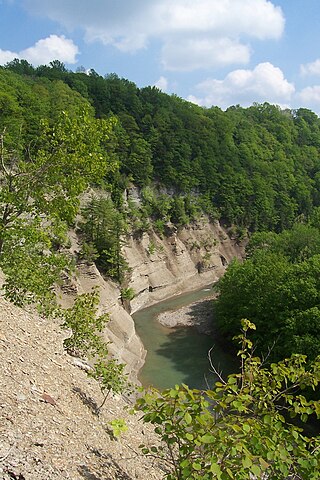
Zoar Valley is an area of deep gorges along the Main and South branches of Cattaraugus Creek in western New York, United States. The valley is located along the border of Erie County and Cattaraugus County, roughly between the villages of Gowanda to the west and Springville to the east.

<span class="mw-page-title-main">Reinstein Woods Nature Preserve</span>

Reinstein Woods Nature Preserve is located near the city of Buffalo in the Town of Cheektowaga in Erie County, New York, USA. Reinstein Woods Nature Preserve is a 292-acre (118 ha) forested complex that also includes wetlands and ponds, located within a developed suburban area. The nature preserve also features an environmental education center.

<span class="mw-page-title-main">Vanderwhacker Mountain Wild Forest</span> New York State Forest

The Vanderwhacker Mountain Wild Forest is a 91,854-acre tract made up of almost two dozen non-contiguous parcels that are designated as Wild Forest by the New York State Department of Environmental Conservation in the central Adirondack Park. The area contains 44 ponds and small lakes, as well as portions of the Hudson and Boreas Rivers. The area is accessible via New York State Route 28 and supports hiking, birding, snowmobiling, Nordic skiing, hunting, camping, canoeing, and fishing.

The Taylor Pond Wild Forest is a discontinuous 53,280-acre area consisting of tracts of state land and easement land spread over a 567 square mile area designated as Wild Forest by the New York State Department of Environmental Conservation in the northeastern Adirondack Park. The area comprises

<span class="mw-page-title-main">New York State Wildlife Management Areas</span> Protected area in New York, US

New York State Wildlife Management Areas (WMAs) are conservation areas managed by the New York State Department of Environmental Conservation (NYSDEC) primarily for the benefit of wildlife, and used extensively by the public for hunting, fishing, and trapping. As of 2016, the NYSDEC owns and maintains 113 WMAs, with a total area of approximately 197,000 acres. The Wildlife Management Areas program is administered by the Division of Fish, Wildlife and Marine Resources of the NYSDEC.

<span class="mw-page-title-main">Sandy Pond Beach Unique Area</span>

Sandy Pond Beach Unique Area is a 76-acre (31 ha) New York State conservation area located within the eastern Lake Ontario dunes. It lies at the north end of a spit of land dividing North Sandy Pond from Lake Ontario, and is about two miles (3.2 km) north of the developed portion of Sandy Island Beach State Park. There is no road access to the area, which can be most easily reached by boat. For this reason, local residents have long referred to the beach as "Boaters' Beach". It has been managed as part of Sandy Island Beach State Park since 2011.

<span class="mw-page-title-main">Labrador Hollow Unique Area</span>

The Labrador Hollow Unique Area is a 1,474-acre (5.97 km2) conservation area located in Cortland and Onondaga counties, New York, and was the first property to be designated as a Unique Area by New York. The area is located adjacent to and between Kettlebail State Forest and Morgan Hill State Forest, and is managed by the New York State Department of Environmental Conservation. The area is open to the public and includes Labrador Pond and Tinker Falls.

References

  1. Strategic Plan for State Forest Management (PDF). NYS Department of Environmental Conservation. July 15, 2011. p. iii. Retrieved May 9, 2016.
  2. 1 2 "State Forests". NYS Department of Environmental Conservation. Retrieved May 9, 2016.
  3. "Rules for Using Lands Managed by the Division of Lands and Forests". NYS Department of Environmental Conservation. Retrieved May 9, 2016.
  4. 1 2 3 "State Land Classifications". NYS Department of Environmental Conservation. Retrieved May 26, 2016.
  5. "List of State Forests". NYS Department of Environmental Conservation. Retrieved May 10, 2016.
  6. "Title 9, Chapter I, Subchapter A, Part 384: Listing of State Parks, Parkways, Recreation Facilities, State Land and Historic Sites (Facilities), DEC Facilities". Official Compilation of Codes, Rules and Regulations of the State of New York. WestlawNext. Retrieved May 18, 2016.
  7. Unless otherwise noted, acreages are sourced from individual pages listed at: "List of State Forests". NYS Department of Environmental Conservation. Retrieved May 10, 2016.
  8. 1 2 3 4 Treaty Line Unit Management Plan (PDF) (Report). NYS Department of Environmental Conservation. p. 4. Retrieved May 22, 2016.
  9. 1 2 3 "Keyserkill State Forest Complex". NYS Department of Environmental Conservation. Retrieved May 10, 2016.
  10. 1 2 3 4 5 6 Taylor Valley Unit Management Plan (PDF) (Report). NYS Department of Environmental Conservation. February 2015. p. 5. Retrieved May 22, 2016.
  11. 1 2 3 4 5 Northern Piedmont Unit Management Plan (PDF) (Report). NYS Department of Environmental Conservation. July 2013. p. 11. Retrieved May 26, 2016.
  12. 1 2 3 4 5 Upper Salmon River Unit Management Plan (PDF) (Report). NYS Department of Environmental Conservation. April 2014. p. 10. Retrieved May 22, 2016.
  13. "Beaver Pond State Forest". NYS Department of Environmental Conservation. Retrieved May 15, 2016.
  14. 1 2 3 4 5 6 7 8 46 Corners Unit Management Plan (PDF) (Report). NYS Department of Environmental Conservation. January 2013. pp. 197–206. Retrieved May 15, 2016.
  15. 1 2 3 4 5 6 "Adirondack Foothills Management Unit". NYS Department of Environmental Conservation. Retrieved May 21, 2016.
  16. 1 2 3 Eminence Unit Management Plan (PDF) (Report). NYS Department of Environmental Conservation. 1995. p. 5. Retrieved May 21, 2016.
  17. 1 2 "St. Lawrence Flatlands Management Unit". NYS Department of Environmental Conservation. Retrieved May 16, 2016.
  18. Brookfield Unit Management Plan (PDF) (Report). NYS Department of Environmental Conservation. February 2016. p. 18. Retrieved May 21, 2016.
  19. 1 2 3 4 5 6 7 8 9 Oneida Hills Unit Management Plan (PDF) (Report). NYS Department of Environmental Conservation. June 2013. p. 13. Retrieved May 26, 2016.
  20. Chenango Trail Unit Management Plan (PDF) (Report). NYS Department of Environmental Conservation. November 2009. p. 8. Retrieved May 26, 2016.
  21. 1 2 Taylor Pond Management Complex Unit Management Plan (PDF) (Report). NYS Department of Environmental Conservation. February 2013. p. 4. Retrieved May 22, 2016.
  22. Camillus Unit Management Plan (PDF) (Report). NYS Department of Environmental Conservation. May 2004. p. 1. Retrieved May 21, 2016.
  23. "Bahar Preserve & Carpenter's Falls". Finger Lakes Land Trust. Retrieved June 12, 2016.
  24. 1 2 3 4 5 Charleston Unit Management Plan (PDF) (Report). NYS Department of Environmental Conservation. August 2009. p. 8. Retrieved May 15, 2016.
  25. 1 2 Vienna Woods Unit Management Plan (PDF) (Report). NYS Department of Environmental Conservation. August 2015. p. 13. Retrieved May 22, 2016.
  26. 1 2 3 "DEC to Prepare Management Plan for State Lands in Clinton County". New York State Department of Environmental Conservation. Archived from the original on June 25, 2013. Retrieved May 22, 2016.
  27. 1 2 3 4 McDonough Unit Management Plan (PDF) (Report). NYS Department of Environmental Conservation. 1999. p. 5. Retrieved May 26, 2016.
  28. 1 2 Tioga Unit Management Plan (PDF) (Report). NYS Department of Environmental Conservation. September 2006. p. 3. Retrieved May 22, 2016.
  29. Hill and Hollow Unit Management Plan (PDF) (Report). NYS Department of Environmental Conservation. January 2013. p. 8. Retrieved May 22, 2016.
  30. 1 2 3 4 5 Draft Unit Management Plan for State Forests in Saratoga and Warren Counties (PDF) (Report). NYS Department of Environmental Conservation. April 2002. pp. 9–10. Retrieved May 20, 2016.
  31. "Maxon Creek State Forest". NYS Department of Environmental Conservation. Retrieved May 21, 2016.
  32. "Montrose Point State Forest". NYS Department of Environmental Conservation. Retrieved May 21, 2016.
  33. Southern Staten Island Unit Management Plan (PDF) (Report). NYS Department of Environmental Conservation. February 2009. p. 18. Retrieved May 26, 2016.
  34. Nelson Swamp Unique Area Unit Management Plan (PDF) (Report). NYS Department of Environmental Conservation. 1999. p. 5. Retrieved June 2, 2016.
  35. "Onondaga Escarpment". ProtectedPlanet. IUCN World Commission on Protected Areas. Retrieved August 13, 2016.
  36. 1 2 Helderbergs Unit Management Plan (PDF) (Report). NYS Department of Environmental Conservation. 2001. pp. 4–5. Retrieved May 21, 2016.
  37. 1 2 3 4 Pharsalia Woods Unit Management Plan (PDF) (Report). NYS Department of Environmental Conservation. February 2013. p. 20. Retrieved May 22, 2016.
  38. "Pharsalia Woods State Forest". NYS Department of Environmental Conservation. Retrieved May 22, 2016.
  39. Dr. Victor Reinstein Woods Nature Preserve Unit Management Plan Unit Management Plan (PDF) (Report). NYS Department of Environmental Conservation. 2006. p. 8. Retrieved June 12, 2016.
  40. Rome Sand Plains Consolidated Management Plan (PDF) (Report). NYS Department of Environmental Conservation. March 3, 2006. p. 10. Retrieved June 2, 2016.
  41. "Region 7 Recreation Master Plan For State Forests/ Draft Generic Environmental Impact Statement" (PDF). New York State Department of Environmental Conservation. February 2006.
  42. 1 2 "Squaw Island Unique Area". NYS Department of Environmental Conservation. Retrieved May 21, 2016.
  43. "Stid Hill". NYS Department of Environmental Conservation. Retrieved May 21, 2016.
  44. "New York State Assembly Bill A07542". New York State Assembly. April 18, 2007. Retrieved May 28, 2016.
  45. "Zoar Valley Multiple Use Area". NYS Department of Environmental Conservation. Retrieved May 25, 2016.