The Green Mountain Boys were a militia organization established in 1770 in the territory between the British provinces of New York and New Hampshire, known as the New Hampshire Grants and later in 1777 as the Vermont Republic. Headed by Ethan Allen and members of his extended family, it was instrumental in resisting New York's attempts to control the territory, over which it had won de jure control in a territorial dispute with New Hampshire.

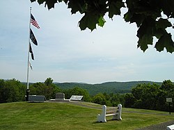
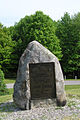
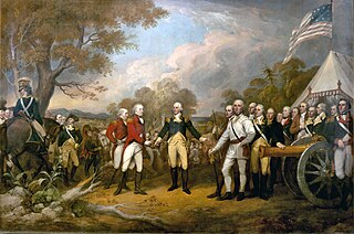
The Battle of Bennington was a battle of the American Revolutionary War, part of the Saratoga campaign, that took place on August 16, 1777, on a farm in Walloomsac, New York, about 10 miles (16 km) from its namesake, Bennington, Vermont. A rebel force of 2,000 men, primarily New Hampshire and Massachusetts militiamen, led by General John Stark, and reinforced by Vermont militiamen led by Colonel Seth Warner and members of the Green Mountain Boys, decisively defeated a detachment of General John Burgoyne's army led by Lieutenant Colonel Friedrich Baum, and supported by additional men under Lieutenant Colonel Heinrich von Breymann.

Major-General John Stark was an American military officer who served during the French and Indian War and the Revolutionary War. He became known as the "Hero of Bennington" for his exemplary service at the Battle of Bennington in 1777.
The Saratoga campaign in 1777 was an attempt by the British high command for North America to gain military control of the strategically important Hudson River valley during the American Revolutionary War. It ended in the surrender of the British army, which historian Edmund Morgan argues, "was a great turning point of the war, because it won for Americans the foreign assistance which was the last element needed for victory."

Bennington is a town in Bennington County, Vermont, United States. It is one of two shire towns of the county, the other being Manchester. As of the 2020 US Census, the population was 15,333. Bennington is the most populous town in southern Vermont, the second-largest town in Vermont and the sixth-largest municipality in the state, including the cities of Burlington, Rutland, and South Burlington.

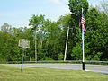
The Walloomsac River from the Native American name, Wal-loom-sac is a 16.8-mile-long (27.0 km) tributary of the Hoosic River in the northeastern United States. It rises in southwestern Vermont, in the Green Mountains east of the town of Bennington in Woodford Hollow at the confluence of Bolles Brook and City Stream where it is labeled Walloomsac Brook on maps but is locally known as "The Roaring Branch". The river then flows west toward Bennington and passes the downtown area to the north. For many years this section was intermittent due to the water having been diverted to power mills in town. This divergence gave the name Walloomsac to a portion of the river flowing through town on the present course of South Stream. The combined Walloomsac / South Stream joins the Roaring Branch northwest of town. From here the river flows westward as the Walloomsac River and joins the Hoosic River below Hoosick Falls, New York.
Friedrich Baum (1727–1777) was a German dragoon Lieutenant Colonel of Brunswick in British service during the American Revolutionary War. Baum served under another German officer, Major General Friedrich Adolf Riedesel, commanding the Dragoon Regiment "Prinz Ludwig" of the Braunschweiger Jäger in support of General John Burgoyne's 1777 campaign to attack the Lake Champlain-Hudson River corridor, which ended in Burgoyne's surrender at Saratoga, New York on October 15, 1777.
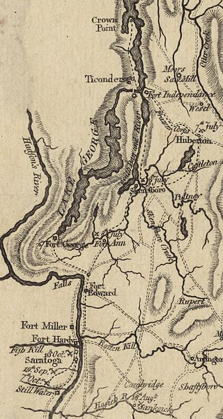
The Battle of Hubbardton was an engagement in the Saratoga campaign of the American Revolutionary War fought in the village of Hubbardton, Vermont. Vermont was then a disputed territory sometimes called the New Hampshire Grants, claimed by New York, New Hampshire, and the newly organized, not yet recognized, but de facto independent government of Vermont. On the morning of July 7, 1777, British forces, under General Simon Fraser, caught up with the American rear guard of the forces retreating after the withdrawal from Fort Ticonderoga. It was the only battle in Vermont during the revolution.

Seth Warner was an American soldier. He was a Revolutionary War officer from Vermont who rose to rank of Continental colonel and was often given the duties of a brigade commander. He is best known for his leadership in the capture of Fort Crown Point, the Battle of Longueuil, the siege of Quebec, the retreat from Canada, and the battles of Hubbardton and Bennington.

The Bennington Battle Monument is a 306-foot-high (93 m) stone obelisk located at 15 Monument Circle, in Bennington, Vermont, United States. The monument commemorates the Battle of Bennington during the American Revolutionary War.
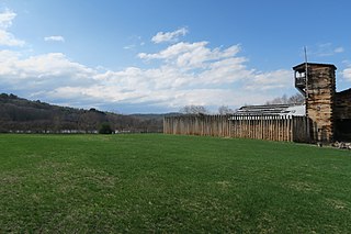
The Fort at Number 4 was a mid-18th century stockade fortification protecting Plantation Number 4, the northernmost British settlement along the Connecticut River in the Province of New Hampshire until after the French and Indian War. It was located in the present-day town of Charlestown, New Hampshire. A recreation of the fort, dating to 1960, now functions as an open-air museum, and was added to the New Hampshire State Register of Historic Places in July 2020.
The New Hampshire Militia was first organized in 1631 and lasted until 1641, when the area came under the jurisdiction of Massachusetts. After New Hampshire became an separate colony again in 1679, New Hampshire Colonial Governor John Cutt reorganized the militia on March 16, 1680, with one foot company apiece for the four major settlements in Portsmouth, Dover, Exeter and Hampton, and an artillery and cavalry company in Portsmouth. The King of England authorized the Provincial Governor to give commissions to persons who shall be best qualified for regulating and discipline of the militia. President Cutt placed Major Richard Waldron of Dover in command of the Militia. In 1879, the Militia was designated by the state as the New Hampshire National Guard.

Oriskany Battlefield State Historic Site is a historic site in Oneida County, New York, United States that marks the Battle of Oriskany, fought in 1777 during the American Revolution, one of the bloodiest engagements of the war.

Molly Stark, née Elizabeth Page was the wife of General John Stark, made famous by his battle cry during the American Revolutionary War. Described as "mother of 11 children, homemaker, patriot, and defender of the household", there are locations and landmarks named for her in at least four states.

Vermont Route 9 is a state highway in the U.S. state of Vermont. The highway runs 46.957 miles (75.570 km) from the New York state line in Bennington, where it continues west as New York State Route 7, to the New Hampshire state line at the Connecticut River in Brattleboro, where the highway continues as New Hampshire Route 9. VT 9 is the primary east–west highway of Bennington and Windham counties in southern Vermont. The highway connects Southern Vermont's primary towns of Bennington and Brattleboro via its crossing of the Green Mountains. VT 9 also connects those towns with Troy, New York, and Keene, New Hampshire, via the connecting highways in those states. The highway also intersects three major north–south routes: U.S. Route 7 in Bennington and Interstate 91 (I-91) and US 5 in Brattleboro.
Bennington Battle Day is a state holiday unique to Vermont, commemorating the victory of American and Vermont forces over British forces at the Battle of Bennington during the American Revolutionary War in 1777. The holiday's date is fixed, occurring on August 16 every year.

The Crown Point Road, or the Crown Point Military Road, is a historic road built in 1759-60, mostly in what is now the United States state of Vermont. It was built by British Army and colonial militia forces to connect Fort Crown Point near the southern end of Lake Champlain to the Fort at Number 4 in what is now Charlestown, New Hampshire. It was the first major road in Vermont, spurring development along its route after the French and Indian War. Fragments of the road are still visible in largely period condition, or have been paved over, while others have disappeared into the forest. Sections of the road located in Weathersfield have been listed on the National Register of Historic Places.

The David Mathews House, also known as the State Line House, is a historic house straddling the state line on New York State Route 67 and Vermont Route 67 in Hoosick, New York and Shaftsbury, Vermont. Built about 1800, it is an imposing brick example of Federal architecture. The building is the subject of a number of tales, some of dubious authenticity. It was listed on the National Register of Historic Places in 1979.
The military history of Vermont covers the military history of the American state of Vermont, as part of French colonial America; as part of Massachusetts, New Hampshire and New York during the British colonial period and during the French and Indian Wars; as the independent New Connecticut and later Vermont during the American Revolution; and as a state during the War of 1812 and the American Civil War.

The Downtown Bennington Historic District encompasses the historic commercial heart of Bennington, Vermont. Centered on the junction of Main, South, and North Streets, it exhibits a variety of commercial architectural styles from the early 19th to mid-20th century. It was listed on the National Register of Historic Places in 1980, and was enlarged in 2008.