
Loudoun County is in the northern part of the Commonwealth of Virginia in the United States. In 2020, the census returned a population of 420,959, making it Virginia's third-most populous county. Loudoun County's seat is Leesburg. Loudoun County is part of the Washington–Arlington–Alexandria, DC–VA–MD–WV Metropolitan Statistical Area. As of 2020, Loudoun County had a median household income of $147,111. Since 2008, the county has been ranked first in the U.S. in median household income among jurisdictions with a population of 65,000 or more.
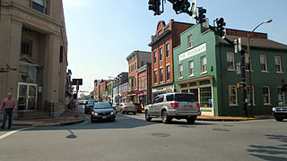
Leesburg is a town in and the county seat of Loudoun County, Virginia, United States. Settlement in the area began around 1740, which is named for the Lee family, early leaders of the town. Located in the far northeast of the state, in the War of 1812 it was a refuge for important federal documents evacuated from Washington, DC, and in the Civil War, it changed hands several times.

Purcellville is a town in Loudoun County, Virginia. The population was 8,929 according to the 2020 Census. Purcellville is the major population center for Western Loudoun and the Loudoun Valley. Many of the older structures remaining in Purcellville reflect the Victorian architecture popular during the early twentieth century.
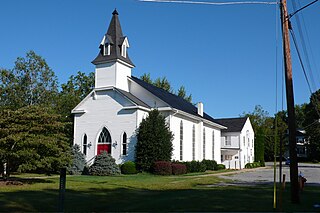
Round Hill is a town in Loudoun County, Virginia, United States. Its population was 539 at the 2010 census and an estimated 656 in 2019. The town is located at the crossroads of Virginia Routes 7 and 719, approximately 50 miles (80 km) northwest of Washington, D.C. The town's name refers a hill two miles northeast of a 910-foot (280 m) hill used during the American Civil War as a signal post by both Confederate and Union troops. House of Round Hill was built in 2004. Patsy Cline went to Round Hill Elementary School.

Sterling, Virginia, refers most specifically to a census-designated place (CDP) in Loudoun County, Virginia, United States. The population of the CDP as of the 2020 United States Census was 30,337 The CDP boundaries are confined to a relatively small area between Virginia State Route 28 on the west and Virginia State Route 7 on the northeast, excluding areas near SR 606 and the Dulles Town Center.

State Route 620 in Fairfax and Loudoun Counties, Virginia is a secondary state highway. The entire length of SR 620 is also known as Braddock Road. SR 620 also has a short concurrency with SR 659 / Union Mill Road in Centreville.

Virginia State Route 7 (VA 7) is a major primary state highway and busy commuter route in northern Virginia, United States. It travels southeast from downtown Winchester to SR 400 in downtown Alexandria. Its route largely parallels those of the Washington & Old Dominion Trail and the Potomac River. Between its western terminus and Interstate 395 (I-395), SR 7 is part of the National Highway System. In 1968, the Virginia State Highway Commission designated the road as the "Harry Flood Byrd Highway" between Alexandria and Winchester to commemorate Harry F. Byrd Sr. (1887–1966).

Aldie is an unincorporated community and census-designated place (CDP) located between Chantilly and Middleburg in Loudoun County, Virginia, United States. The historic village of Aldie is located on the John Mosby Highway in a gap between the Catoctin Mountains and Bull Run Mountains, through which the Little River flows. Aldie traditionally serves as the gateway to the Loudoun Valley and beyond.

State Route 28 in the U.S. state of Virginia is a primary state highway that traverses the counties of Loudoun, Fairfax, Prince William, and Fauquier in the U.S. state of Virginia. The route serves as a major artery in the Northern Virginia region, with it being an important two-lane highway in rural Fauquier and Prince William Counties, the main thoroughfare through Manassas and Manassas Park, and a high-capacity freeway through Fairfax and Loudoun Counties.

U.S. Route 50 is a transcontinental highway which stretches from Ocean City, Maryland to West Sacramento, California. In the U.S. state of Virginia, US 50 extends 86 miles (138 km) from the border with Washington, D.C. at a Potomac River crossing at Rosslyn in Arlington County to the West Virginia state line near Gore in Frederick County.
Neersville is an unincorporated community in northwestern Loudoun County, Virginia, United States. It is located in the Between the Hills area of the Loudoun Valley on Harpers Ferry Road at the foot of Short Hill Mountain. It is notable for being the birthplace of Confederate guerrilla John Mobberly.

Woodburn is an unincorporated community in Loudoun County, Virginia. The village is located on Hogback Mountain southwest of Leesburg. Woodburn Road, which runs between Dry Mill and Harmony Church Roads, is all that is left to mark the existence and location of the community. The ruins of Woodburn's general store stood just north of the road's intersection with Forrestgrove Road until about 2000 when the Virginia Department of Transportation (VDOT), overturned the Loudoun County Board of Supervisors' decision to leave the road unpaved and paved and widened the road, demolishing the general store in the process.
Georges Mill is an unincorporated village in northern Loudoun County, Virginia. The community takes its name from the mill that once operated there on Dutchman Creek to the north of Elvan. Georges Mill is located at the crossroads of Irish Corner Road and Georges Mill Road.

State Route 609 in Fairfax County, Virginia is a secondary state highway which traverses western portion of the county. The road is also known as Pleasant Valley Road.
The Loudoun County Parkway is a secondary state highway in eastern Loudoun County, Virginia. The southern portion is signed as State Route 606 from Braddock Road north to Old Ox Road, with the remainder signed as State Route 607.

Wilson Gap, originally known as Gregory's Gap, is a wind gap in the Blue Ridge Mountain, located on the border of Loudoun County, Virginia and Jefferson County, West Virginia. The Appalachian Trail crosses the gap.
Loudoun County Transit is a public-transportation service provided by the Loudoun County, Virginia government. Loudoun County Transit provides fixed routes and on-demand/paratransit bus service.
Elvan is a name used in Cornwall and Devon for the native varieties of quartz-porphyry. They are dispersed irregularly in the Devonian series of rocks and some of them make very fine building stones. Greenstone is another name for this stone and it is often used for parts of buildings such as doorways so they can be finely carved. Most of the elvan quarries are now disused. Others are quarried in bulk for aggregates commonly used for road-building.

State Route 606 in Fairfax and Loudoun Counties, Virginia is a secondary state highway traversing the communities of Reston, Herndon, Sterling, Arcola, and South Riding. The road is important not only because it is an inter-county connector, but it goes around the back of Dulles Airport, is part of the Loudoun County Parkway, and it provides a shortcut between the Reston / Herndon area and U.S. Route 50. Although the Herndon streets are not technically part of SR 606, they are signed as SR 606, and they connect to streets that are part of SR 606, thus providing a continuous route.
One Loudoun is a census-designated place (CDP) in Loudoun County, Virginia, United States. It is a mixed-use development just south of Virginia State Route 7, 29 miles (47 km) northwest of Washington, D.C., and 7 miles (11 km) southeast of Leesburg. One Loudoun was developed since the 2010 census, so it was not recognized as a census-designated place until the 2020 census. The community has an Ashburn mailing address.


