Empire, Georgia

Last updated

Empire, Georgia
USA Georgia location map.svg
Red pog.svg
Empire
Coordinates: 32°20′25″N83°17′46″W / 32.34028°N 83.29611°W / 32.34028; -83.29611
Country United States
State Georgia
Counties Bleckley, Dodge
Area
[1]
  Total2.32 sq mi (6.00 km2)
  Land2.30 sq mi (5.96 km2)
  Water0.02 sq mi (0.04 km2)
Elevation
386 ft (118 m)
Population
 (2020)
  Total319
  Density138.70/sq mi (53.54/km2)
Time zone UTC-5 (Eastern (EST))
  Summer (DST) UTC-4 (EDT)
ZIP code
31014
Area code 478
FIPS code 13-27512 [2]
GNIS feature ID0313945 [3]

Empire is an unincorporated community and census-designated place in Dodge and Bleckley counties in the U.S. state of Georgia. As of the 2020 census, the CDP had a population of 319.

Contents

History

The Georgia General Assembly incorporated the place in 1911 as the "Town of Empire". [4] Founders of the community named it "Empire" in order to promote a sawmill established there. [5] The town's municipal charter was repealed in 1995. [5]

Geography

Empire is located primarily in Dodge County but extends west into Bleckley County as well. U.S. Route 23 passes through the CDP, leading north 4 miles (6 km) to Cochran, the Bleckley County seat, and south 12 miles (19 km) to Eastman, the Dodge County seat. Macon is 42 miles (68 km) to the north via US-23.

According to the United States Census Bureau, the CDP has a total area of 2.3 square miles (6.0 km2), of which 0.015 square miles (0.04 km2), or 0.72%, is water. [6]

Demographics

Historical population
CensusPop.Note
1920 970
1930 158−83.7%
1940 1622.5%
1950 157−3.1%
2010 393
2020 319−18.8%
U.S. Decennial Census [7]
1850-1870 [8] 1870-1880 [9]
1890-1910 [10] 1920-1930 [11]
1940 [12] 1950 [13] 1960 [14]
1970 [15] 1980 [16] 1990 [17]
2000 [18] 2010 [19] 2020 [20]

Empire first appeared as an incorporated place in the 1920 U.S. Census through the 1950 U.S. Census. It did not appear in the 1960 through the 2000 U.S. censuses. It was relisted as a census designated place in the 2010 U.S. Census.

Empire, Georgia – Racial and ethnic composition
Note: the US Census treats Hispanic/Latino as an ethnic category. This table excludes Latinos from the racial categories and assigns them to a separate category. Hispanics/Latinos may be of any race.
Race / Ethnicity (NH = Non-Hispanic)Pop 2010 [19] Pop 2020 [20] % 2010% 2020
White alone (NH)32725983.21%81.19%
Black or African American alone (NH)615415.52%16.93%
Native American or Alaska Native alone (NH)110.25%0.31%
Asian alone (NH)100.25%0.00%
Pacific Islander alone (NH)000.00%0.00%
Some Other Race alone (NH)000.00%0.00%
Mixed Race or Multi-Racial (NH)010.00%0.31%
Hispanic or Latino (any race)340.76%1.25%
Total393319100.00%100.00%

Related Research Articles

<span class="mw-page-title-main">Kings Bay Base, Georgia</span> Place in Georgia, United States

Kings Bay Base is an unincorporated community and census-designated place (CDP) in Camden County, Georgia, United States; it is home to the Kings Bay Naval Submarine Base. The population was 1,777 at the 2010 census, and 2,329 in 2020.

<span class="mw-page-title-main">Skidaway Island, Georgia</span> Place in Georgia, United States

Skidaway Island is an unincorporated community and census-designated place (CDP) in Chatham County, Georgia, and lies on a barrier island of the same name. Located south of Savannah, Skidaway Island is known for its waterfront properties and golf courses within The Landings, one of the largest gated communities in the country. The population was 9,310 at the 2020 census. For statistical purposes, the United States Census Bureau has defined Skidaway Island as a census-designated place (CDP). A separate area of the island hosts the Skidaway Institute of Oceanography, a research institution operated by the University of Georgia. It receives scholars and researchers from several other Georgia universities as well, including Georgia Tech, Savannah State University, and the College of Coastal Georgia. Skidaway Island is part of the Savannah Metropolitan Statistical Area.

<span class="mw-page-title-main">Martinez, Georgia</span> Place in Georgia, United States

Martinez is an unincorporated community and census-designated place (CDP) in Columbia County, Georgia, United States. It is a northwestern suburb of Augusta and is part of the Augusta, Georgia metropolitan area. The population was 34,535 at the 2020 census.

<span class="mw-page-title-main">Country Club Estates, Georgia</span> Place in Georgia, United States

Country Club Estates is an unincorporated community and census-designated place (CDP) in Glynn County, Georgia, United States. It is part of the Brunswick metropolitan statistical area. The population was 8,373 at the 2020 census, down from 8,545 in 2010.

<span class="mw-page-title-main">Coleman, Georgia</span> Place in Georgia, United States

Coleman is a former incorporated city in Randolph County, Georgia, United States. It is listed as a census-designated place (CDP). The population was 149 at the 2000 census. The city was abolished by House Bill 1102 effective January 1, 2007, and no longer exists as a municipality.

<span class="mw-page-title-main">Hiltonia, Georgia</span> City in Georgia, United States

Hiltonia is a city in Screven County, Georgia, United States. The population was 310 in 2020.

<span class="mw-page-title-main">Danville, Georgia</span> Town in Georgia, United States

Danville is a town in Twiggs and Wilkinson counties in the U.S. state of Georgia. The population was 238 at the 2010 census, down from 373 in 2000.

<span class="mw-page-title-main">Deenwood, Georgia</span> Place in Georgia, United States

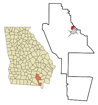
Deenwood is an unincorporated community and census-designated place (CDP) in Ware County, Georgia, United States. The population was 2,207 at the 2020 census. It is part of the Waycross micropolitan statistical area. Deenwood Baptist Church is named after this geographical area.

<span class="mw-page-title-main">Sunnyside, Georgia</span> Place in Georgia, United States

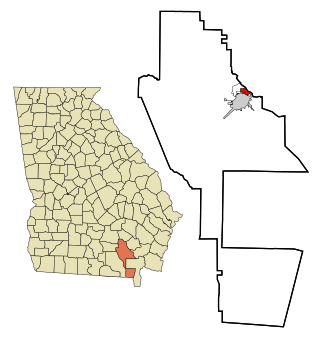
Sunnyside is an unincorporated community and census-designated place (CDP) in Ware County, Georgia, United States. The population was 1,472 in 2020. It is part of the Waycross micropolitan statistical area.

Cataula is an unincorporated community and census-designated place (CDP) in Harris County, Georgia, United States.

<span class="mw-page-title-main">Boykin, Georgia</span> Place in Georgia, United States

Boykin is an unincorporated community and census-designated place (CDP) in Miller County, Georgia, United States. The 2020 census listed a population of 151.

The Rock is an unincorporated community and census-designated place in Upson County, Georgia, United States. The Rock is located on Georgia State Route 36, 7 miles (11 km) northeast of Thomaston. The Rock has a post office with ZIP code 30285, although the post office is on the list to be closed. The Rock is also home to the area-famous Rock Ranch, a small theme park with a farming theme. The Rock is bordered by the cities of Barnesville, Hannahs Mill, Meansville, and Yatesville.

Seville is an unincorporated community and census-designated place (CDP) in Wilcox County, Georgia, United States. Per the 2020 census, the population was 197. It lies approximately 0.5 miles (0.80 km) away from the Crisp County line, and about 4 miles (6.4 km) away from Pitts.

Epworth is an unincorporated community and census-designated place (CDP) in Fannin County, Georgia, United States. As of the 2010 census it had a population of 480. It lies at an elevation of 1,703 feet (519 m) in the north-central part of the county. A former name was Atalla. The ZIP code is 30541.

<span class="mw-page-title-main">Mineral Bluff, Georgia</span> Place in Georgia, United States

Mineral Bluff is a census-designated place and unincorporated community located in Fannin County in the U.S. state of Georgia. Its population was 223 as of the 2020 census. The community is situated 6 miles (10 km) northeast of the city of Blue Ridge, the county seat, 80 miles (130 km) east of Chattanooga, Tennessee, and 100 miles (160 km) north of Atlanta.

Cedar Springs is an unincorporated community and census-designated place (CDP) in Early County, Georgia, United States. At the time of the 2020 census, the population was 75. Cedar Springs has a post office with ZIP code 39832. Georgia State Route 273 passes through the community. Georgia Pacific is 2 miles southwest from it.

<span class="mw-page-title-main">Cherry Log, Georgia</span> Place in Georgia, United States

Cherry Log is an unincorporated community and census-designated place (CDP) in Gilmer County, Georgia, United States. Its population was 99 as of the 2020 census. Cherry Log has a post office with ZIP code 30522. U.S. Route 76 passes through the community. Through the heart of Cherry Log runs Cherry Log Street, on which is found the Post Office, Cornerstone Baptist Church, Cherry Log Christian Church, and the Pink Pig, a restaurant in operation since 1950.

Norristown is an unincorporated community and census-designated place (CDP) in Emanuel County, Georgia, United States. Its population was 54 as of the 2020 census.

Canoochee is an unincorporated community and census-designated place (CDP) in Emanuel County, Georgia, United States. Its population was 70 as of the 2020 census.

Godfrey is an unincorporated community and census-designated place in Morgan County, in the U.S. state of Georgia. It first appeared as a CDP in the 2020 Census with a population of 108.

References

  1. "2020 U.S. Gazetteer Files". United States Census Bureau. Retrieved December 18, 2021.
  2. "U.S. Census website". United States Census Bureau . Retrieved January 31, 2008.
  3. "US Board on Geographic Names". United States Geological Survey. October 25, 2007. Retrieved January 31, 2008.
  4. Acts Passed by the General Assembly of Georgia. J. Johnston. 1911. p. 1146.
  5. 1 2 Krakow, Kenneth K. (1975). Georgia Place-Names: Their History and Origins (PDF). Macon, GA: Winship Press. p. 73. ISBN   0-915430-00-2.
  6. "Geographic Identifiers: 2010 Demographic Profile Data (G001): Empire CDP, Georgia". U.S. Census Bureau, American Factfinder. Archived from the original on February 12, 2020. Retrieved November 5, 2013.
  7. "Decennial Census of Population and Housing by Decade". US Census Bureau.
  8. "1870 Census of Population - Georgia - Population of Civil Divisions less than Counties" (PDF). US Census Bureau . 1870.
  9. "1880 Census of Population - Georgia - Population of Civil Divisions less than Counties" (PDF). US Census Bureau . 1880.
  10. "1910 Census of Population - Georgia" (PDF). US Census Bureau . 1930.
  11. "1930 Census of Population - Georgia" (PDF). US Census Bureau . 1930. p. 251-256.
  12. "1940 Census of Population - Georgia" (PDF). US Census Bureau . 1940.
  13. "1950 Census of Population - Georgia" (PDF). US Census Bureau . 1980.
  14. "1960 Census of Population - Population of County Subdivisions - Georgia" (PDF). US Census Bureau . 1960.
  15. "1970 Census of Population - Population of County Subdivisions - Georgia" (PDF). US Census Bureau . 1970.
  16. "1980 Census of Population - Number of Inhabitants - Georgia" (PDF). US Census Bureau . 1980.
  17. "1990 Census of Population - Summary Social, Economic, and Housing Characteristics - Georgia" (PDF). US Census Bureau . 1990.
  18. "2000 Census of Population - General Population Characteristics - Georgia" (PDF). US Census Bureau . 2000.
  19. 1 2 "P2 Hispanic or Latino, and Not Hispanic or Latino by Race – 2010: DEC Redistricting Data (PL 94-171) – Empire CDP, Georgia". United States Census Bureau .
  20. 1 2 "P2 Hispanic or Latino, and Not Hispanic or Latino by Race – 2020: DEC Redistricting Data (PL 94-171) – Empire CDP, Georgia". United States Census Bureau .