Eastman, Georgia

Last updated

Eastman, Georgia
City
City of Eastman
Eastman Municipal Building, City Hall, Council Chamber.JPG
Eastman City Hall in Eastman
City of Eastman.png
Nicknames: 
Candy Capital of Georgia, Azalea City, Paris of the Wiregrass [1]
Dodge County Georgia Incorporated and Unincorporated areas Eastman Highlighted.svg
Location in Dodge County and the state of Georgia
Coordinates: 32°11′52″N83°10′45″W / 32.19778°N 83.17917°W / 32.19778; -83.17917
CountryUnited States
State Georgia
County Dodge
Government
  Type Council-Manager
   City Manager J. Spencer Barron
  Council ChairmanGraham Snyder
  Council Vice-ChairmanSebrina Williams
Area
[2]
  Total6.53 sq mi (16.90 km2)
  Land6.47 sq mi (16.75 km2)
  Water0.06 sq mi (0.16 km2)
Elevation
390 ft (119 m)
Population
 (2020)
  Total5,658
  Density875.04/sq mi (337.84/km2)
Time zone UTC-5 (EST)
  Summer (DST) UTC-4 (EDT)
ZIP code
31023
Area code 478
FIPS code 13-25552 [3]
GNIS feature ID0355610 [4]
Website cityofeastman.com

Eastman is a city in Dodge County, Georgia, United States. The population was 5,658 at the 2020 census, up from 4,962 at the 2010 census. [5] The city was named after William Pitt Eastman, a native of Massachusetts who purchased a large tract of land along the Macon and Brunswick Railroad, and settled a city on the site.

Contents

In the 19th century, this was a center of the timber and sawmill industry. During the Great Depression in 1937, the first Stuckey's Pecan Shoppe, once well-known along roadways throughout the United States, was founded in Eastman.

History

The first permanent settlement of the area took place in 1840. [6] The population continued to grow when, in 1869, a station was built for the newly constructed Macon and Brunswick Railroad which passed through the area, stimulating an economic boom. The settlement was originally named Levison and was renamed Eastman by December 1869. Eastman was designated as the seat of newly formed Dodge County in 1871. It was incorporated as a town in 1873 and as a city in 1905. [7] Eastman is named for W. P. Eastman, who, with W. E. Dodge, presented the county with a courthouse. [8]

During that same time period, Ira Roe Foster, former Quartermaster General of Georgia, operated a sawmill in Dodge County. In 1869, Foster built a residence in what would become Eastman. Foster was one of many who came to the area to participate in the timber and sawmill boom.

During the boom, it was estimated that, on average, there was one mill every two miles along the industrial corridor created by the Macon and Brunswick Railroad. [9] Unlike earlier eras, when timber was transported downstream in large river rafts, sawmills along the industrial corridor shipped their timber by rail. In his book The New South Comes to Wiregrass Georgia 1860-1910, author Mark V. Wetherington states: "Ira R. Foster shipped lumber to Brunswick, where it was loaded onto timber schooners and transported to international markets like Liverpool, Rio de Janeiro, and Havana." [9] When Eastman was incorporated in 1872, Foster served as its first mayor. [10]

In the early years of the 20th century, racial tensions increased between the white and black communities in and about Eastman, resulting in a number of documented lynchings. In one instance, a man misidentified as the rapist Ed Claus was murdered before the real Claus was identified, apprehended, and lynched. [11] In 1919, rumors that local blacks were intending to rise up and exterminate white residents, led to the murder of Eli Cooper and the burning of several black churches, which were believed to be the focal point of the uprising. [12]

Geography

Eastman is located in the center of Dodge County at 32°11′52″N83°10′45″W / 32.19778°N 83.17917°W / 32.19778; -83.17917 (32.197760, -83.179271). [13] U.S. Route 23 passes through the center of town, leading northwest 17 miles (27 km) to Cochran and southeast 20 miles (32 km) to McRae-Helena. U.S. Route 341 bypasses the city on the southwest, leading west 20 miles (32 km) to Hawkinsville and southeast with US 23 to McRae-Helena. Sugar Creek runs to the southwest of the city.

According to the United States Census Bureau, Eastman has a total area of 5.5 square miles (14.2 km2), of which 5.4 square miles (14.0 km2) is land and 0.04 square miles (0.1 km2), or 0.93%, is water. [5]

Climate

Climate data for Eastman, Georgia
MonthJanFebMarAprMayJunJulAugSepOctNovDecYear
Record high °F (°C)83
(28)
84
(29)
92
(33)
95
(35)
102
(39)
110
(43)
109
(43)
105
(41)
102
(39)
102
(39)
89
(32)
85
(29)
110
(43)
Mean daily maximum °F (°C)57.0
(13.9)
61.2
(16.2)
69.9
(21.1)
77.7
(25.4)
84.4
(29.1)
84.4
(29.1)
91.5
(33.1)
91.3
(32.9)
87.1
(30.6)
78.8
(26.0)
69.7
(20.9)
60.9
(16.1)
76.6
(24.8)
Mean daily minimum °F (°C)35.0
(1.7)
37.6
(3.1)
45.1
(7.3)
51.9
(11.1)
59.7
(15.4)
59.7
(15.4)
69.8
(21.0)
69.1
(20.6)
64.2
(17.9)
53.0
(11.7)
44.8
(7.1)
37.8
(3.2)
52.9
(11.6)
Record low °F (°C)−2
(−19)
10
(−12)
15
(−9)
29
(−2)
39
(4)
45
(7)
56
(13)
52
(11)
36
(2)
28
(−2)
12
(−11)
4
(−16)
−2
(−19)
Average precipitation inches (mm)5.05
(128)
4.38
(111)
4.84
(123)
3.58
(91)
2.93
(74)
4.53
(115)
5.12
(130)
3.90
(99)
3.33
(85)
2.73
(69)
3.18
(81)
3.67
(93)
46.40
(1,179)
Source 1: The Weather Channel [14]
Source 2: Weatherbase [15]

Demographics

Historical population
CensusPop.Note
1890 1,082
1900 1,23514.1%
1910 2,35590.7%
1920 2,70714.9%
1930 3,02211.6%
1940 3,3119.6%
1950 3,5978.6%
1960 5,11842.3%
1970 5,4165.8%
1980 5,330−1.6%
1990 5,153−3.3%
2000 5,4405.6%
2010 4,962−8.8%
2020 5,65814.0%
U.S. Decennial Census [16]
Eastman racial composition as of 2020 [17]
RaceNum.Perc.
White (non-Hispanic)2,77849.1%
Black or African American (non-Hispanic)2,39942.4%
Native American 50.09%
Asian 540.95%
Pacific Islander 40.07%
Other/Mixed 1823.22%
Hispanic or Latino 2364.17%

As of the 2020 United States census, there were 5,658 people, 1,916 households, and 1,343 families residing in the city.

Recreation

Eastman has few recreational activities. The Dodge County Golf Club has a 9-hole golf course, a swimming pool and private golf cart selection. It is positioned next to the railroad tracks that run through the town. The Eastman-Dodge County Recreational Fields, located along the Eastman-Dublin Highway (Highway 117), offers the following public sports for kids: football, baseball, tee ball, cheerleading, soccer, and girl's flag football.

Education

Dodge County School District

Dodge County students in kindergarten to twelfth grades are in the Dodge County School District, which consists of a pre-K school, two elementary schools, a middle school, and a high school. [18] [19] The district has 210 full-time teachers and over 3,500 students. [18]

Higher education

Middle Georgia State College - Eastman Campus at the Heart of Georgia Regional Airport Middle Georgia State College, Eastman Campus.JPG
Middle Georgia State College - Eastman Campus at the Heart of Georgia Regional Airport

Peabody School

Peabody School, also known as Peabody High School, is an historic school building located on Herman Avenue in Eastman, Georgia. [22] Built in 1938, it was designed by Eastman-born American architect Edward Columbus Hosford, who is noted for the courthouses and other buildings that he designed in Florida, Georgia and Texas. In the days of segregation, it was an all-black public school. It was closed in 1970 and its students were integrated into Dodge County High School and other formerly all-white public schools in Dodge County.

On November 20, 2004, the building was added to the National Register of Historic Places. It was then vacant and in private ownership.

Transportation

Notable people

Related Research Articles

<span class="mw-page-title-main">Wilcox County, Georgia</span> County in Georgia, United States

Wilcox County is a county located in the central portion of the U.S. state of Georgia. As of the 2020 census, the population was 8,766. The county seat is Abbeville.

<span class="mw-page-title-main">Lowndes County, Georgia</span> County in Georgia, United States

Lowndes County is a county located in the south-central portion of the U.S. state of Georgia. As of the 2020 census, the population was 118,251. The county seat is Valdosta. The county was created December 23, 1825.

<span class="mw-page-title-main">Dodge County, Georgia</span> County in Georgia, United States

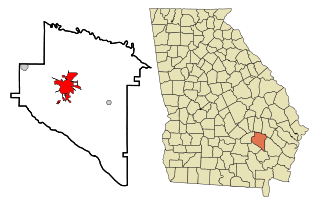
Dodge County is a county located in the central portion of the U.S. state of Georgia. As of 2020, the population was 19,925. The county seat is Eastman. Dodge County lies in the Historic South and Black Belt region of Georgia, an area that was devoted to cotton production in the antebellum years. It has significant historic buildings and plantations, has a substantial African-American population, and shows cultural aspects of the South.

<span class="mw-page-title-main">Baxley, Georgia</span> City in Georgia, United States

Baxley is a city in Appling County, Georgia, United States. As of the 2020 census, the city had a population of 4,942. The city is the county seat of Appling County.

<span class="mw-page-title-main">Cochran, Georgia</span> City in Georgia, United States

Cochran is a city in Bleckley County, Georgia, United States. As of the 2020 census, the city had a population of 5,026. The city is the county seat of Bleckley County.

<span class="mw-page-title-main">Nahunta, Georgia</span> City in Georgia, United States

Nahunta is a city and the county seat in Brantley County, Georgia, United States. It is part of the Brunswick, Georgia metropolitan statistical area. The population was 1,013 at the 2020 census. The city is an important crossroad which is intersected by U.S. Route 82 and U.S. Route 301 in its downtown area.

<span class="mw-page-title-main">Chauncey, Georgia</span> City in Georgia, United States

Chauncey is a city in Dodge County, Georgia, United States. The population was 289 at the 2020 census. It was formed around station number twelve on the Macon and Brunswick Railroad.

<span class="mw-page-title-main">Chester, Georgia</span> Town in Georgia, United States

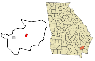
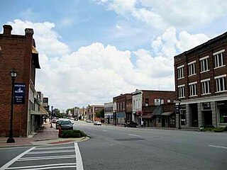
Chester is a town in Dodge County, Georgia, United States. The population was 1,596 at the 2010 census, up from 305 in 2000, due to inclusion of Dodge State Prison within the town limits. By 2020, its township population was 525.

<span class="mw-page-title-main">Rhine, Georgia</span> Town in Georgia, United States

Rhine is a town in Dodge County, Georgia, United States. The population was 295 in 2020.

<span class="mw-page-title-main">Hamilton, Georgia</span> City in Georgia, United States

Hamilton is a city in, and the county seat of Harris County, Georgia, United States. It is part of the Columbus, Georgia-Alabama metropolitan statistical area. The population was 1,680 at the 2020 census, up from 307 at the 2000 census.

<span class="mw-page-title-main">Oglethorpe, Georgia</span> City in Georgia, United States

Oglethorpe is a city in Macon County, Georgia, United States. The population was 995 at the 2020 census, down from 1,328 in 2010. The city is the county seat of Macon County. It was named for Georgia's founder, James Oglethorpe.

<span class="mw-page-title-main">Forsyth, Georgia</span> City in Georgia, United States

Forsyth is a city in and the county seat of Monroe County, Georgia, United States. The population was 4,384 at the 2020 census, up from 3,788 in 2010. Forsyth is part of the Macon metropolitan statistical area.

<span class="mw-page-title-main">Hawkinsville, Georgia</span> City in Georgia, United States

Hawkinsville is a city in and the county seat of Pulaski County, Georgia, United States. The population was 3,980 in 2020.

<span class="mw-page-title-main">McRae, Georgia</span> City in Georgia, United States

McRae was a city in and the county seat of Telfair County, Georgia, United States. It was designated as the seat in 1871, after being established the previous year as a station on the Macon and Brunswick Railroad. Upon the city's merger with adjacent Helena in 2015, the new county seat is the combined city of McRae-Helena.

<span class="mw-page-title-main">Jesup, Georgia</span> City in Georgia, United States

Jesup is a city in Wayne County, Georgia, United States. The population was 9,809 at the 2020 census. The city is the county seat of Wayne County.

<span class="mw-page-title-main">Laurel, Mississippi</span> City in Mississippi, United States

Laurel is a city in and the second county seat of Jones County, Mississippi, United States. As of the 2020 census, the city had a population of 17,161. Laurel is northeast of Ellisville, the first county seat, which contains the first county courthouse. It has the second county courthouse, as Jones County has two judicial districts. Laurel is the headquarters of the Jones County Sheriff's Department, which administers in the county. Laurel is the principal city of a micropolitan statistical area named for it. Major employers include Howard Industries, Sanderson Farms, Masonite International, Family Health Center, Howse Implement, Thermo-Kool, and South Central Regional Medical Center. Laurel is home to the Lauren Rogers Museum of Art, Mississippi's oldest art museum, established by the family of Lauren Eastman Rogers.

Edward Columbus Hosford, also known as Edward C. Hosford and E. C. Hosford, was an American architect noted for the courthouses and other buildings that he designed in Florida, Georgia and Texas.

The Macon and Brunswick Railroad ran from Macon, Georgia to Brunswick, Georgia. Its construction was interrupted by the American Civil War, and initially only ran from Macon to Cochran, Georgia. The 5 ft gauge line was completed and extended to the Georgia coast when it opened in its entirety in December 1869. Construction of the line stimulated the lumber industry along its path, and the founding of new towns and counties.

Empire is an unincorporated community and census-designated place in Dodge and Bleckley counties in the U.S. state of Georgia. As of the 2020 census, the CDP had a population of 319.

<span class="mw-page-title-main">McRae–Helena, Georgia</span> City in Georgia, United States

McRae–Helena is a city in the U.S. state of Georgia, formed on January 1, 2015, by the merger of the two cities of McRae and Helena. McRae–Helena is the county seat of Telfair County.

References

  1. "Eastman" . Retrieved July 13, 2015.
  2. "2020 U.S. Gazetteer Files". United States Census Bureau. Retrieved December 18, 2021.
  3. "U.S. Census website". United States Census Bureau . Retrieved January 31, 2008.
  4. "US Board on Geographic Names". United States Geological Survey. October 25, 2007. Retrieved January 31, 2008.
  5. 1 2 "Geographic Identifiers: 2010 Demographic Profile Data (G001): Eastman city, Georgia". U.S. Census Bureau, American Factfinder. Retrieved October 21, 2015.[ dead link ]
  6. Krakow, Kenneth K. (1975). Georgia Place-Names: Their History and Origins (PDF). Macon, GA: Winship Press. p. 68. ISBN   0-915430-00-2.
  7. Hellmann, Paul T. (May 13, 2013). Historical Gazetteer of the United States. Routledge. p. 228. ISBN   978-1135948597 . Retrieved November 30, 2013.
  8. Gannett, Henry (1905). The Origin of Certain Place Names in the United States. Govt. Print. Off. pp.  112.
  9. 1 2 Mark V. Wetherington (September 1, 2001). The New South Comes to Wiregrass Georgia, 1860-1910 - Timber Is King. Univ. of Tennessee Press. pp. 113–114. ISBN   978-1-57233-168-6.
  10. 1 2 Philip Cobb, Mrs. Wilton (1932). "History of Dodge County" . Retrieved October 27, 2013.
  11. Ralph Ginzburg (1965). 100 Years of Lynchings. Black Press Classic. pp.  60–61. ISBN   978-0-933121-18-8.
  12. Ralph Ginzburg (1965). 100 Years of Lynchings. Black Classic Press. p.  123. ISBN   978-0-933121-18-8.
  13. "US Gazetteer files: 2010, 2000, and 1990". United States Census Bureau. February 12, 2011. Retrieved April 23, 2011.
  14. "The Weather Channel: Monthly Averages". The Weather Channel. Archived from the original on October 22, 2012. Retrieved June 6, 2010.
  15. "Historical Weather for Eastman, Georgia, United States". Weatherbase. Retrieved June 6, 2010.
  16. "Census of Population and Housing". Census.gov. Retrieved June 4, 2015.
  17. "Explore Census Data". data.census.gov. Retrieved December 18, 2021.
  18. 1 2 "school-stats.com". Archived from the original on July 16, 2011. Retrieved May 21, 2010.
  19. Georgia Board of Education [ permanent dead link ], Retrieved June 6, 2010.
  20. Dodge County High School Archived 2010-05-10 at the Wayback Machine , Retrieved July 27, 2010.
  21. Middle Georgia College- Aviation Campus Archived 2010-07-26 at the Wayback Machine , Retrieved July 27, 2010.
  22. Peabody High School Archived 2011-02-07 at the Wayback Machine , Retrieved July 27, 2010.