Lumpkin, Georgia

Last updated

Lumpkin, Georgia
Stewart County Courthouse in Lumpkin, Georgia, USA, July 2008.jpg
Stewart County Courthouse in Lumpkin
Stewart County Georgia Incorporated and Unincorporated areas Lumpkin Highlighted.svg
Location within Stewart County and Georgia
Coordinates: 32°2′59″N84°47′45″W / 32.04972°N 84.79583°W / 32.04972; -84.79583
Country United States
State Georgia
County Stewart
Area
[1]
  Total1.60 sq mi (4.14 km2)
  Land1.58 sq mi (4.10 km2)
  Water0.02 sq mi (0.04 km2)
Elevation
600 ft (183 m)
Population
 (2020)
  Total891
  Density563.21/sq mi (217.50/km2)
Time zone UTC-5 (Eastern (EST))
  Summer (DST) UTC-4 (EDT)
ZIP code
31815
Area code 229
FIPS code 13-47980 [2]
GNIS feature ID0317484 [3]
Website cityoflumpkin.org

Lumpkin is a city and county seat of Stewart County, Georgia, United States. Per the 2020 census, the population was 891. [4]

Contents

History

This area of Georgia was inhabited by succeeding cultures of indigenous Native Americans for thousands of years before European contact. Historical tribes included the Cherokee, Choctaw and Creek, who encountered European Americans as their settlements moved into traditional territory. During the Indian removal of 1830, the United States government forced such tribes to move west of the Mississippi River to Indian Territory, to extinguish their claims and make way for more European-American settlement.[ citation needed ]

Lumpkin was incorporated by European Americans on March 30, 1829. First named the county seat of Randolph County on December 2, 1830, it became the seat of Stewart County when the latter was split from Randolph three weeks later. The city was named in honor of Wilson Lumpkin, a two-term governor of Georgia and legislator who supported Indian removal. His namesake county is at the northern end of the state. [5]

The town grew as a commercial center served by stagecoach. Its merchants traded with the planters in the area. This was part of the Black Belt, named for the fertile land in the upland South that supported extensive cotton plantations in the 19th century. In the antebellum years, planters depended on the labor and skills of hundreds of thousands of enslaved African Americans to cultivate and process the cotton for market. [5]

After the war, many freedmen stayed in the area as sharecroppers and tenant farmers, and the economy continued to depend on agriculture. With land erosion and depletion, cotton farming gave way to peanut and pine tree cultivation, and labor needs decreased. The population of the county dropped markedly from the Great Migration of blacks to industrial jobs in the North and Midwest in the early decades of the 20th century, but the town of Lumpkin remained relatively stable. The county is still quite rural. [5]

Lumpkin was the first small town in Georgia to complete a successful historic preservation project to encourage what has become known as heritage tourism. It restored the Bedingfield Inn, built in 1836 and located on the central square. It is listed on the National Register of Historic Places.

On December 5, 1954, a destructive F2 tornado hit the northwest side of town, killing one and injuring 20. [6] [7]

In the 1960s, a group of citizens created a living history complex known as Westville. They relocated 30 historic structures to create a grouping of western Georgia architecture as would have been found in an 1850s working village. Some of the buildings were purchased from the collection of John Word West established in 1928 in Jonesboro, Georgia. The village, staffed by volunteers to give the sense of daily life, has since moved to Columbus, Georgia. [5]

The nearby private Stewart Detention Center houses federal detainees for the U.S. Immigration and Customs Enforcement. The facility is owned and run by CoreCivic. In 2011 Stewart ranked as the largest and busiest such facility in the United States. Stewart County's share of revenue from the federal government, 85 cents per inmate per day, amounted to more than half of the county's entire annual budget. [8] It was removed from the 2020 U.S. Census geography for Lumpkin city hence the decline in population.

Geography

Lumpkin is located at 32°02′59″N84°47′45″W / 32.049638°N 84.795859°W / 32.049638; -84.795859 . [9] U.S. Route 27 passes west of the city, leading north 37 miles (60 km) to Columbus and south 132 miles (212 km) to Tallahassee, Florida. Georgia State Route 27 also passes through the city, leading southwest 24 miles (39 km) to Georgetown on the Alabama state line and east 9 miles (14 km) to Richland.

According to the United States Census Bureau, the city has a total area of 1.6 square miles (4.1 km2), of which 1.6 square miles (4.1 km2) is land and 0.04 square miles (0.10 km2) (1.25%) is water.

Demographics

Historical population
CensusPop.Note
1860 765
1870 7781.7%
1880 747−4.0%
1900 1,470
1910 1,140−22.4%
1920 934−18.1%
1930 1,10318.1%
1940 1,2109.7%
1950 1,209−0.1%
1960 1,34811.5%
1970 1,4316.2%
1980 1,335−6.7%
1990 1,250−6.4%
2000 1,3699.5%
2010 2,741100.2%
2020 891−67.5%
U.S. Decennial Census [10]
2010 [11] 2020 [12]
Lumpkin city, Georgia – Racial and ethnic composition
Note: the US Census treats Hispanic/Latino as an ethnic category. This table excludes Latinos from the racial categories and assigns them to a separate category. Hispanics/Latinos may be of any race.
Race / Ethnicity (NH = Non-Hispanic)Pop 2010 [11] Pop 2020 [12] % 2010% 2020
White alone (NH)39624614.45%27.61%
Black or African American alone (NH)89359932.58%67.23%
Native American or Alaska Native alone (NH)560.18%0.67%
Asian alone (NH)2801.02%0.00%
Pacific Islander alone (NH)010.00%0.11%
Some Other Race alone (NH)930.33%0.34%
Mixed Race or Multi-Racial (NH)10200.36%2.24%
Hispanic or Latino (any race)1,4001651.08%1.80%
Total2,741891100.00%100.00%

Note: the US Census treats Hispanic/Latino as an ethnic category. This table excludes Latinos from the racial categories and assigns them to a separate category. Hispanics/Latinos can be of any race.

At the census [2] of 2000, there were 1,369 people, 552 households, and 367 families residing in the city; by 2020, its population declined to 891. [12]

Government

The current mayor of Lumpkin is Jimmy Babb. Charles Gibson, his predecessor, elected in 2010, was the first African-American elected to this office.

Education

The Stewart County School District holds pre-school to grade twelve, and consists of an elementary school, middle school, and high school. [13] The district has 58 full-time teachers and over 704 students. [14]

Notable People

Related Research Articles

<span class="mw-page-title-main">Russell County, Alabama</span> County in Alabama, United States

Russell County is a county in the southeastern part of the U.S. state of Alabama. As of the 2020 census, the population was 59,183. Its county seat is Phenix City. Its name is in honor of Colonel Gilbert C. Russell, who fought in the wars against the Creek Indians.

<span class="mw-page-title-main">Talbot County, Georgia</span> County in Georgia, United States

Talbot County is a county located in the west central portion of the U.S. state of Georgia. The 2020 census showed a population of 5,733. The county seat and largest city is Talbotton.

<span class="mw-page-title-main">Stewart County, Georgia</span> County in Georgia, United States

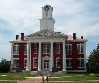
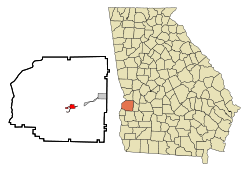
Stewart County is a county located in the west central portion of the U.S. state of Georgia. As of the 2020 census, the population was 5,314. The county seat is Lumpkin. The county was created on December 23, 1830.

<span class="mw-page-title-main">Randolph County, Georgia</span> County in Georgia, United States

Randolph County is a county located in the southwestern portion of the U.S. state of Georgia and is considered part of the Black Belt, historically an area of plantations. As of the 2020 census, the population was 6,425, roughly one-third of its peak population in 1910, when there were numerous agricultural workers. The county seat is Cuthbert.

<span class="mw-page-title-main">Newton County, Georgia</span> County in Georgia, United States

Newton County is a county located in the north central portion of the U.S. state of Georgia. As of the 2020 census, the population was 112,483. The county seat is Covington.

<span class="mw-page-title-main">Dougherty County, Georgia</span> County in Georgia, United States

Dougherty County is located in the southwestern portion of the U.S. state of Georgia. As of the 2020 census, the population was 85,790. The county seat and sole incorporated city is Albany.

<span class="mw-page-title-main">Clarke County, Georgia</span> County in Georgia, United States

Clarke County is located in the northeastern part of the U.S. state of Georgia. As of the 2020 census, the population was 128,671. Its county seat is Athens, with which it is a consolidated city-county. Clarke County is included in the Athens-Clarke County, GA Metropolitan Statistical Area, which is also included in the Atlanta-Athens-Clarke County-Sandy Springs, GA Combined Statistical Area.

<span class="mw-page-title-main">Catoosa County, Georgia</span> County in Georgia, United States

Catoosa County is a county located in the northwestern part of the U.S. state of Georgia. As of the 2020 census, the population was 67,872. The county seat is Ringgold. The county was created on December 5, 1853. The meaning of the Cherokee language name "Catoosa" is obscure: "Catoosa" may come from the Cherokee words gatusi or gatu'gitse.

<span class="mw-page-title-main">Carroll County, Georgia</span> County in Georgia, United States

Carroll County is a county located in the northwestern part of the State of Georgia. As of the 2020 census, its population was 119,148. Its county seat is the city of Carrollton. Carroll County is included in the Atlanta-Sandy Springs-Roswell metropolitan statistical area and is also adjacent to Alabama on its western border.

<span class="mw-page-title-main">Elaine, Arkansas</span> City in Arkansas, United States

Elaine is a small town in Phillips County, Arkansas, United States, in the Arkansas Delta region of the Mississippi River. The population was 636 at the 2010 census.

<span class="mw-page-title-main">Damascus, Georgia</span> City in Georgia, United States

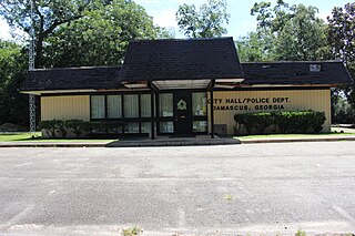
Damascus is a city in Early County, Georgia, United States. The population was 212 in the 2020 census, down from 254 in the 2010 census.

<span class="mw-page-title-main">Warner Robins, Georgia</span> City in Georgia, United States

Warner Robins is a city in Houston and Peach counties in the U.S. state of Georgia. It is currently the state's eleventh-largest incorporated city, with a population of 80,308 in the 2020 census.

<span class="mw-page-title-main">Oglethorpe, Georgia</span> City in Georgia, United States

Oglethorpe is a city in Macon County, Georgia, United States. The population was 995 at the 2020 census, down from 1,328 in 2010. The city is the county seat of Macon County. It was named for Georgia's founder, James Oglethorpe.

<span class="mw-page-title-main">Columbus, Georgia</span> Consolidated city-county in the United States

Columbus is a consolidated city-county located on the west-central border of the U.S. state of Georgia. Columbus lies on the Chattahoochee River directly across from Phenix City, Alabama. It is the county seat of Muscogee County, with which it officially merged in 1970; the original merger excluded Bibb City, which joined in 2000 after dissolving its own city charter.

<span class="mw-page-title-main">Georgetown, Quitman County, Georgia</span> City in Georgia, United States

Georgetown is a city in Quitman County, Georgia, United States. It is on the Alabama-Georgia state line next to Walter F. George Lake and across the Chattahoochee River from Eufaula, Alabama. Per the 2020 census, the population was 2,235. In 2006, Georgetown and Quitman County voted to consolidate their governments, becoming the smallest such consolidated entity in the Lower 48 states.

<span class="mw-page-title-main">Richland, Georgia</span> City in Georgia, United States

Richland is a city in Stewart County, Georgia, United States. Per the 2020 census, the population was 1,370.

<span class="mw-page-title-main">Plains, Georgia</span> City in Georgia, United States

Plains is a city in Sumter County, Georgia, United States. The population was 573 at the 2020 census and it is a part of the Americus Micropolitan Statistical Area. It is best known as the birthplace of Jimmy Carter and his wife Rosalynn, who were the president and first lady of the United States respectively from 1977 to 1981. They lived in Plains both before and after their time in the White House.

<span class="mw-page-title-main">Crawfordville, Georgia</span> City in Georgia, United States

Crawfordville is a city in Taliaferro County, Georgia, United States. The population was 479 in 2020. The city is the county seat of Taliaferro County.

<span class="mw-page-title-main">Knoxville, Georgia</span> Place in Georgia, United States

Knoxville is an unincorporated community and census-designated place in Crawford County, Georgia, United States. It is the county seat of Crawford County. The community is part of the Macon Metropolitan Statistical Area. As of the 2020 census, Knoxville had a population of 65.

<span class="mw-page-title-main">Ellerslie, Georgia</span> Place in Georgia, United States

Ellerslie is an unincorporated community and census-designated place (CDP) in Harris County, Georgia, United States. Ellerslie is a part of the Columbus, Georgia metropolitan area.

References

  1. "2020 U.S. Gazetteer Files". United States Census Bureau. Retrieved December 18, 2021.
  2. 1 2 "U.S. Census website". United States Census Bureau . Retrieved January 31, 2008.
  3. "US Board on Geographic Names". United States Geological Survey. October 25, 2007. Retrieved January 31, 2008.
  4. "Lumpkin city, Georgia". United States Census Bureau . Retrieved April 15, 2022.
  5. 1 2 3 4 Matthew M. Moye, "Lumpkin", New Georgia Encyclopedia, 17 Dec 2006, accessed 7 Jan 2009
  6. "Georgia Event Report: F2 Tornado". NCDC. National Climatic Data Center. Retrieved July 4, 2020.
  7. Grazulis, Thomas P. (July 1993). Significant Tornadoes 1680–1991: A Chronology and Analysis of Events. St. Johnsbury, Vermont: The Tornado Project of Environmental Films. p. 983. ISBN   1-879362-03-1.
  8. Redmon, Jeremy (January 17, 2011). "Georgia deportation jail largest in nation". The Atlanta Journal-Constitution. Retrieved August 1, 2016.
  9. "US Gazetteer files: 2010, 2000, and 1990". United States Census Bureau. February 12, 2011. Retrieved April 23, 2011.
  10. "Decennial Census of Population and Housing by Decades". US Census Bureau.
  11. 1 2 "P2 Hispanic or Latino, and Not Hispanic or Latino by Race – 2010: DEC Redistricting Data (PL 94-171) – Lumpkin city, Georgia". United States Census Bureau .
  12. 1 2 3 "P2 Hispanic or Latino, and Not Hispanic or Latino by Race – 2020: DEC Redistricting Data (PL 94-171) – Lumpkin city, Georgia". United States Census Bureau .
  13. Georgia Board of Education [ permanent dead link ], Retrieved June 26, 2010.
  14. School Stats, Retrieved June 26, 2010.

Further reading