Related Research Articles

Montgomery County is a county located in the central portion of the U.S. state of Georgia. As of the 2020 census, the population was 8,610. The county seat is Mount Vernon.

Telfair County is a county located in the central portion of the U.S. state of Georgia. As of the 2020 census, the population was 12,477. The largest city and county seat is McRae-Helena.

Cadwell is a town in Laurens County, Georgia, United States. The population was 528 at the 2010 census, up from 329 at the 2000 census. It is part of the Dublin Micropolitan Statistical Area.

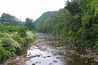
The Ocmulgee River is a western tributary of the Altamaha River, approximately 255 mi (410 km) long, in the U.S. state of Georgia. It is the westernmost major tributary of the Altamaha. It was formerly known by its Hitchiti name of Ocheese Creek, from which the Creek (Muscogee) people derived their name.
Muncy Creek is a tributary of the West Branch Susquehanna River in Sullivan County and Lycoming County, at Pennsylvania, in the United States. It is approximately 34.5 miles (55.5 km) long. The watershed of the creek has an area of 216 square miles (560 km2). The creek's discharge averages 49 cubic feet per second (1.4 m3/s) at Sonestown, but can be up to a thousand times higher at Muncy. The headwaters of the creek are on the Allegheny Plateau. Rock formations in the watershed include the Chemung Formation and the Catskill Formation.
Otter Creek may refer to some places in the North America:
The Alcovy River is a 69-mile-long (111 km) tributary of the Ocmulgee River in north-central Georgia in the United States. It is part of the watershed of the Altamaha River, which flows to the Atlantic Ocean.
Meshoppen Creek is a tributary of the Susquehanna River in Susquehanna and Wyoming counties, Pennsylvania, in the United States. It is approximately 30.6 miles (49.2 km) long and flows through Bridgewater Township, Dimock Township, and Springville Township in Susquehanna County and Lemon Township, Washington Township, Meshoppen Township, and Meshoppen in Wyoming County. The watershed of the creek has an area of 114 square miles (300 km2). It is possible to canoe on 17.0 miles (27.4 km) of Meshoppen Creek.

Black Creek is a long source tributary of Nescopeck Creek so part of the Susquehanna River drainage basin. It is also the second & longer stream of the same name recognized by the USGS GNIS system in Luzerne County, Pennsylvania, in the United States—compared to the Black Creek beyond the ridgeline of the drainage divide, so in the Lehigh River valley and Carbon County. The headwaters of both Black Creeks in Luzerne county are only a few miles apart, and both valleys were traversed by the Lausanne-Nescopeck Turnpike in the first half of the 19th-century.
Stony Brook is a tributary of Mehoopany Creek in Wyoming County, Pennsylvania, in the United States. It is approximately 4.3 miles (6.9 km) long and flows through North Branch township and Forkston Township. The brook has a tributary known as Red Brook. Logging was done in the upper reaches of the watershed of Stony Brook in the early 1900s.

Mahanoy Creek is a 51.6-mile-long (83.0 km) tributary of the Susquehanna River in Northumberland and Schuylkill counties, Pennsylvania. There are at least 35 sources of acid mine drainage in the creek's watershed. Anthracite was mined in the upper part of the Mahanoy Creek watershed in the 19th and 20th centuries. Mahanoy Creek's tributaries include Schwaben Creek, Zerbe Run, Little Mahanoy Creek, Shenandoah Creek, and North Mahanoy Creek. Little Mahanoy Creek and Schwaben Creek are two streams in the watershed that are unaffected by acid mine drainage. Schwaben Creek has a higher number and diversity of fish species than the main stem.

U.S. Route 441 (US 441) in the U.S. state of Georgia is a 354.2-mile-long (570.0 km) north–south United States Highway through the east-central portion of the state. It travels from the Florida state line near the Fargo city area to the North Carolina state line, in the northern part of Dillard. It is a spur route of US 41, although it has no intersections with its "parent" route within the state. It does have an intersection with another spur route of US 41 however, specifically US 341 in McRae–Helena.
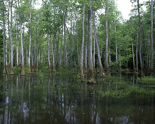
Bond Swamp National Wildlife Refuge, located 6 miles south of Macon, Georgia, United States, was established in 1989 to protect, maintain and enhance the forested wetland ecosystem of the Ocmulgee River floodplain. It opened to the public in 2000 and currently consists of 6,500 acres situated along the fall line separating the Piedmont and Coastal Plains. The refuge has a diversity of vegetation communities, including mixed hardwood-pine, bottomland hardwoods, tupelo gum swamp forests, creeks, tributaries, beaver swamps and oxbow lakes. The refuge is rich in wildlife diversity including white-tailed deer, wood ducks, black bears, alligators, wild turkey, a nesting pair of bald eagles and excellent wintering habitat for waterfowl. Extensive bottomland hardwoods provide critical habitat for neotropical songbirds of concern, such as Swainson's warbler, wood thrush, prothonotary warbler and yellow-billed cuckoo. The combination of warm weather and wet areas at Bond Swamp provide ideal conditions for a variety of reptile and amphibian species.
Chino Creek is a major stream of the Pomona Valley, in the western Inland Empire region of Southern California. It is a tributary of the Santa Ana River.
Geronimo Creek is a stream in South Central Texas, U.S., that runs approximately 17 miles, from its source one mile east of Clear Springs, Texas, to its confluence with the Guadalupe River in Guadalupe County, Texas, three miles southeast of Seguin.

Spring Brook is a tributary of the Lackawanna River in Lackawanna County and Luzerne County, in Pennsylvania, in the United States. It is approximately 17 miles (27 km) long and flows through Covington Township, Spring Brook Township, and Moosic in Lackawanna County and Pittston Township in Luzerne County. The watershed of the stream has an area of 57.2 square miles (148 km2). It is designated as a High-Quality Coldwater Fishery and a Migratory Fishery above Interstate 476 and as a Coldwater Fishery and a Migratory Fishery below it. A section is also designated as Class A Wild Trout Waters. The stream's tributaries include Panther Creek, Plank Bridge Creek, Rattlesnake Creek, Green Run, Monument Creek, and Covey Swamp Creek. It has a relatively high level of water quality and is very slightly acidic, with a pH of 6.4 to 6.9.
The West Branch Lackawanna River is a tributary of the Lackawanna River in Susquehanna County, Pennsylvania, in the United States. It is approximately 9.5 miles (15.3 km) long and flows through Ararat Township, Herrick Township, and Union Dale. The watershed of the river has an area of 16.8 square miles (44 km2). The river is not designated as an impaired stream and it has a high level of water quality. Lakes and wetlands in the river's watershed include Ball Lake, Fiddle Lake, Hathaway Lake, Lake Romobe, Lewis Lake, Lowe Lake, and Sink Hole Swamp. The river is also dammed by at least two dams: the Romobe Lake Dam and the Hathaway Pond Dam.

McRae–Helena is a city in the U.S. state of Georgia, formed on January 1, 2015, by the merger of the two cities of McRae and Helena. McRae–Helena is the county seat of Telfair County.
East Branch Tunkhannock Creek is a tributary of Tunkhannock Creek in Susquehanna County, Pennsylvania, in the United States. It is approximately 19 miles (31 km) long and flows through Gibson Township, Herrick Township, Clifford Township, and Lenox Township, Susquehanna County, Pennsylvania. The watershed of the creek has an area of 68.3 square miles (177 km2). The creek has four named tributaries: Little Creek, Tinker Creek, Dundaff Creek, and Idlewild Creek. It is not designated as an impaired waterbody and is a freestone stream in its upper reaches. The topography of the watershed has been described as "rough and hilly".
References
- ↑ U.S. Geological Survey Geographic Names Information System: Sugar Creek (Ocmulgee River tributary)
- ↑ J. R. Haswell, "Telfair County", Drainage Examinations and Surveys in Georgia (1911), p. 62.
| | This Wheeler County, Georgia state location article is a stub. You can help Wikipedia by expanding it. |
| | This Telfair County, Georgia state location article is a stub. You can help Wikipedia by expanding it. |