
Pinus albicaulis, known by the common names whitebark pine, white bark pine, white pine, pitch pine, scrub pine, and creeping pine, is a conifer tree native to the mountains of the western United States and Canada, specifically subalpine areas of the Sierra Nevada, Cascade Range, Pacific Coast Ranges, and Rocky Mountains. It shares the common name "creeping pine" with several other plants.

The Great Basin Desert is part of the Great Basin between the Sierra Nevada and the Wasatch Range. The desert is a geographical region that largely overlaps the Great Basin shrub steppe defined by the World Wildlife Fund, and the Central Basin and Range ecoregion defined by the U.S. Environmental Protection Agency and United States Geological Survey. It is a temperate desert with hot, dry summers and snowy winters. The desert spans large portions of Nevada and Utah, and extends into eastern California. The desert is one of the four biologically defined deserts in North America, in addition to the Mojave, Sonoran, and Chihuahuan Deserts.

The ecology of the Sierra Nevada, located in the U.S. states of California and Nevada, is diverse and complex. The combination of climate, topography, moisture, and soils influences the distribution of ecological communities across an elevation gradient from 500 to 14,500 feet. Biotic zones range from scrub and chaparral communities at lower elevations, to subalpine forests and alpine meadows at the higher elevations. Particular ecoregions that follow elevation contours are often described as a series of belts that follow the length of the Sierra Nevada. There are many hiking trails, paved and unpaved roads, and vast public lands in the Sierra Nevada for exploring the many different biomes and ecosystems.
The Rocky Mountains subalpine zone is the biotic zone immediately below tree line in the Rocky Mountains of North America. In northern New Mexico, the subalpine zone occupies elevations approximately from 9,000 to 12,000 feet ; while in northern Alberta, the subalpine zone extends from 1,350 to 2,300 metres.
The Fremont-Winema National Forest of south central Oregon is a mountainous region with a rich geological, ecological, archaeological, and historical history. Founded in 1908, the Fremont National Forest was originally protected as the Goose Lake Forest Reserve in 1906. The name was soon changed to Fremont National Forest, named after John C. Frémont, who explored the area for the United States Army Corps of Engineers in 1843. It absorbed part of Paulina National Forest on July 19, 1915. In 2002, it was administratively combined with the Winema National Forest as the Fremont–Winema National Forests.

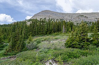
The Sierra Nevada subalpine zone refers to a biotic zone below treeline in the Sierra Nevada mountain range of California, United States. This subalpine zone is positioned between the upper montane zone at its lower limit, and tree line at its upper limit.

The Eastern Cascades Slopes and Foothills ecoregion is a Level III ecoregion designated by the United States Environmental Protection Agency (EPA) in the U.S. states of Oregon, Washington, and California. In the rain shadow of the Cascade Range, the eastern side of the mountains experiences greater temperature extremes and receives less precipitation than the west side. Open forests of ponderosa pine and some lodgepole pine distinguish this region from the Cascades ecoregion, where hemlock and fir forests are more common, and from the lower, drier ecoregions to the east, where shrubs and grasslands are predominant. The vegetation is adapted to the prevailing dry, continental climate and frequent wildfire. Volcanic cones and buttes are common in much of the region.

The Blue Mountains ecoregion is a Level III ecoregion designated by the United States Environmental Protection Agency (EPA) in the Pacific Northwest, mainly in the state of Oregon, with small areas over the state border in Idaho and southeastern Washington. It is also contiguous with the World Wildlife Fund's Blue Mountain forests ecoregion.

The Northern Basin and Range ecoregion is a Level III ecoregion designated by the United States Environmental Protection Agency (EPA) in the U.S. states of Oregon, Idaho, Nevada, Utah, and California. It contains dissected lava plains, rolling hills, alluvial fans, valleys, and scattered mountain ranges in the northern part of the Great Basin. Although arid, the ecoregion is higher and cooler than the Snake River Plain to the north and has more available moisture and a cooler climate than the Central Basin and Range to the south. Its southern boundary is determined by the highest shoreline of Pleistocene Lake Bonneville, which once inundated the Central Basin and Range. The western part of the region is internally drained; its eastern stream network drains to the Snake River system.

On a per-person basis, Wyoming emits more carbon dioxide than any other state or any other country: 276,000 pounds (125,000 kg) of it per capita a year, because of burning coal, which provides nearly all of the state's electrical power.

Like other parts of the world, climate in Idaho has changed dramatically over the geologic history of the Earth. Paleo-climatic records give some indication of these changes. The longest instrumented records of climate in Idaho extend back to the late 1800s. Concern over human induced climate change through the emission of carbon dioxide from fossil fuels and methane from agriculture and industry, are driving research efforts across the state at university, state, and federals levels to understand what the implications of climate change could be in Idaho.

The ecology of the Rocky Mountains is diverse due to the effects of a variety of environmental factors. The Rocky Mountains are the major mountain range in western North America, running from the far north of British Columbia in Canada to New Mexico in the southwestern United States, climbing from the Great Plains at or below 1,800 feet (550 m) to peaks of over 14,000 feet (4,300 m). Temperature and rainfall varies greatly also and thus the Rockies are home to a mixture of habitats including the alpine, subalpine and boreal habitats of the Northern Rocky Mountains in British Columbia and Alberta, the coniferous forests of Montana and Idaho, the wetlands and prairie where the Rockies meet the plains, a different mix of conifers on the Yellowstone Plateau in Wyoming, the montane forests of Utah, and in the high Rockies of Colorado and New Mexico, and finally the alpine tundra of the highest elevations.

The South Central Rockies forests is a temperate coniferous forest ecoregion of the United States located mainly in Wyoming, Idaho, and Montana. It has a considerably drier climate than the North Central Rockies forest.

The North Central Rockies forests is a temperate coniferous forest ecoregion of Canada and the United States. This region overlaps in large part with the North American inland temperate rainforest and gets more rain on average than the South Central Rockies forests and is notable for containing the only inland populations of many species from the Pacific coast.

The Great Basin montane forests is an ecoregion of the Temperate coniferous forests biome, as designated by the World Wildlife Fund (WWF).

South Chilcotin Mountains Provincial Park is a provincial park in British Columbia, Canada, located on Highway 40 northwest of Lillooet, British Columbia. The park, which is 56,796 ha. in size, was established on April 18, 2001, and It was created out of a portion of the Spruce Lake Protected Area. The park is located on three Indigenous Nations: The Tsilhqot’in, St’at’imc, and Secwepemc.

The Idaho Batholith ecoregion is a Level III ecoregion designated by the United States Environmental Protection Agency (EPA) in the U.S. states of Idaho and Montana. It is contained within the following biomes designated by the World Wild Fund for Nature (WWF): temperate coniferous forests; temperate grasslands, savannas, and shrublands; and deserts and xeric shrublands.
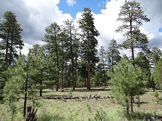
Ponderosa pine forest is a plant association and plant community dominated by ponderosa pine and found in western North America. It is found from the British Columbia to Durango, Mexico. In the south and east, ponderosa pine forest is the climax forest, while in the more northern part of its range, it can transition to Douglas-fir or grand fir, or white fir forests. Understory species depends on location. Fire suppression has led to insect outbreaks in ponderosa pine forests.

Okanagan dry forests is a temperate coniferous forest ecoregion in the Pacific Northwest of North America, as defined by the World Wildlife Fund (WWF) categorization system. It is closely associated with the Okanagan region of British Columbia and Washington. Only 20% of the ecosystem is still intact, and continues to be under threat for preservation due to land clearing and urban expansion, alongside the increasing threats of fire and extreme weather due to climate change.
The Northwestern Forested Mountains is a Level I ecoregion of North America designated by the Commission for Environmental Cooperation (CEC) in its North American Environmental Atlas.


