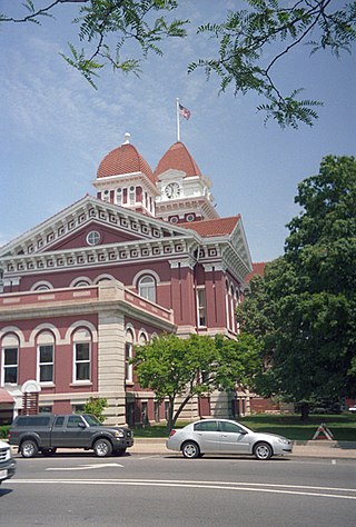
Lake County is a county located in the U.S. state of Indiana. In 2020, its population was 498,700, making it Indiana's second-most populous county. The county seat is Crown Point. The county is part of Northwest Indiana and the Chicago metropolitan area, and contains a mix of urban, suburban and rural areas. It is bordered on the north by Lake Michigan and contains a portion of the Indiana Dunes. It includes Marktown, Clayton Mark's planned worker community in East Chicago.

Griffith is a town in North and St. John townships in Lake County, Indiana, United States. It is a part of the Chicago metropolitan area. The population was 16,420 in 2020. The town's population is currently declining at a rate of 0.69% annually. Griffith is the town with the 11th largest population and 17th largest town by area in the State of Indiana.

Highland is a town in Lake County, Indiana, United States. The population was 23,984 at the 2020 census. The town was incorporated on April 4, 1910. It is a part of the Chicago metropolitan area and North Township, and is surrounded by Hammond to the north, Munster to the west, Schererville to the south and Griffith to the east.

Merrillville is a town in Ross Township, Lake County, Indiana, United States. The population was 35,246 at the 2010 census. Merrillville is in east-central Lake County, in the Chicago metropolitan area. On January 1, 2015, Merrillville became the most populated town in Indiana, as Fishers in Hamilton County was converted from a town to a city. The town serves as a major shopping hub for Northwest Indiana.

Schererville is a town in St. John Township, Lake County, Indiana, United States. The population was 29,646 at the 2020 census It is a suburb of Chicago, located 30 miles south of the city.

The Monon Railroad, also known as the Chicago, Indianapolis, and Louisville Railway from 1897 to 1971, was an American railroad that operated almost entirely within the state of Indiana. The Monon was merged into the Louisville and Nashville Railroad in 1971, and much of the former Monon right of way is owned today by CSX Transportation. In 1970, it operated 540 miles (870 km) of road on 792 miles (1,275 km) of track; that year it reported 1320 million ton-miles of revenue freight and zero passenger-miles.

The Monon Trail is a rail trail located entirely within the state of Indiana. The Monon Railroad was a popular railroad line connecting the cities of Chicago and Indianapolis, with stops at major settlements along its route. After the decline of railroad travel and the sale of the company in 1987, the portion of the line between Indianapolis and Delphi, Indiana, was abandoned.
The Calumet Region is the geographic area drained by the Grand Calumet River and the Little Calumet River of northeastern Illinois and northwestern Indiana in the United States. It is part of the Great Lakes Basin, which eventually reaches the Atlantic Ocean. It is a sub-region of the greater Northwest Indiana region and the even larger Great Lakes region.
Northwest Indiana, nicknamed The Region after the Calumet Region, comprises Lake, Porter, LaPorte, and Newton counties in Indiana. This region neighbors Lake Michigan and is part of the Chicago metropolitan area. According to the 2020 Census, Northwest Indiana has a population of 831,080 and is the state's second largest urban area after the Indianapolis Metropolitan Area. It is also the home of the Indiana Dunes, parts of which have been preserved through conservation efforts. The town of Ogden Dunes houses the Hour Glass, a museum showcasing the ecological and conservation efforts of O. D. Frank.
The West Lake Corridor is an under-construction commuter rail line in Lake County, Indiana. New South Shore Line services are planned to connect the towns of Munster and Dyer in Indiana with Hammond, Indiana and Chicago, Illinois.
The Gary Public Transportation Corporation (GPTC) is a commuter bus system in Gary, Indiana that offers service to numerous stops throughout the city and neighboring suburbs. GPTC is a public corporation owned but not directly controlled by the city.
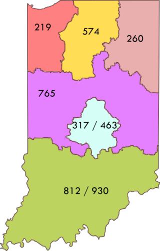
Area code 219 is a telephone area code in the North American Numbering Plan for Northwest Indiana, including the state's portion of the Chicago metropolitan area. The numbering plan area includes the cities of Schererville, Chesterton, Lake Station, Lowell, Crown Point, Cedar Lake, Hobart, Whiting, Gary, Hammond, East Chicago, Merrillville, Munster, Griffith, Highland, Portage, Valparaiso, Michigan City, Ogden Dunes, St. John, La Porte, DeMotte, Roselawn, Kouts, Lake Village, and Rensselaer. 219 is largely co-extensive with the Indiana side of the Chicago metropolitan area, of which it includes the Lake, Porter, La Porte, Newton, and Jasper counties. Service is provided by AT&T, Frontier Communications, and Northwestern Indiana Telephone Company.

The Genesee Valley Greenway is a rail trail in western New York's Genesee River valley.

The Cincinnati, Richmond & Muncie Depot is a restored train station in Muncie, Indiana, United States. Built in 1901, it was acquired by the Chesapeake and Ohio Railway in 1910. The station was used for passenger train service throughout the 20th century and was added to the National Register of Historic Places in 1997. It is currently used as a visitor center and office for the adjacent Cardinal Greenway.
The Ghost Town Trail is a rail trail in Western Pennsylvania that runs 36 miles (58 km) between Black Lick, Indiana County, and Ebensburg, Cambria County. Established in 1991 on the right-of-way of the former Ebensburg and Black Lick Railroad, the trail follows the Blacklick Creek and passes through many ghost towns that were abandoned in the early 1900s with the decline of the local coal mining industry. Open year-round to cycling, hiking, and cross-country skiing, the trail is designated a National Recreation Trail by the United States Department of the Interior.
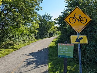
The Camp Chase Trail is a paved multi-use trail in Madison and Franklin counties in the U.S. state of Ohio. It serves as the Southwest Columbus segment of the 326-mile (525 km) Ohio to Erie Trail. The entire length of the Camp Chase Trail is part of the Great American Rail-Trail, U.S. Bicycle Route 21 and U.S. Bicycle Route 50.
The Pennsy Greenway is a rail trail in the Chicago metropolitan area running from Lansing, Illinois to Schererville, Indiana. The trail runs on the former Penn Central Railway, and is currently incomplete, but is paved at segments in Lansing, Munster, Dyer, Schererville, and Crown Point. The trail is paved through these segments at a total of 12.5 miles, and the trail is planned to extend for a total of 15 miles.

