Related Research Articles

Erosion is the action of surface processes that removes soil, rock, or dissolved material from one location on the Earth's crust and then transports it to another location where it is deposited. Erosion is distinct from weathering which involves no movement. Removal of rock or soil as clastic sediment is referred to as physical or mechanical erosion; this contrasts with chemical erosion, where soil or rock material is removed from an area by dissolution. Eroded sediment or solutes may be transported just a few millimetres, or for thousands of kilometres.
Soil erosion is the denudation or wearing away of the upper layer of soil. It is a form of soil degradation. This natural process is caused by the dynamic activity of erosive agents, that is, water, ice (glaciers), snow, air (wind), plants, and animals. In accordance with these agents, erosion is sometimes divided into water erosion, glacial erosion, snow erosion, wind (aeolian) erosion, zoogenic erosion and anthropogenic erosion such as tillage erosion. Soil erosion may be a slow process that continues relatively unnoticed, or it may occur at an alarming rate causing a serious loss of topsoil. The loss of soil from farmland may be reflected in reduced crop production potential, lower surface water quality and damaged drainage networks. Soil erosion could also cause sinkholes.

Sediment is a naturally occurring material that is broken down by processes of weathering and erosion, and is subsequently transported by the action of wind, water, or ice or by the force of gravity acting on the particles. For example, sand and silt can be carried in suspension in river water and on reaching the sea bed deposited by sedimentation; if buried, they may eventually become sandstone and siltstone through lithification.

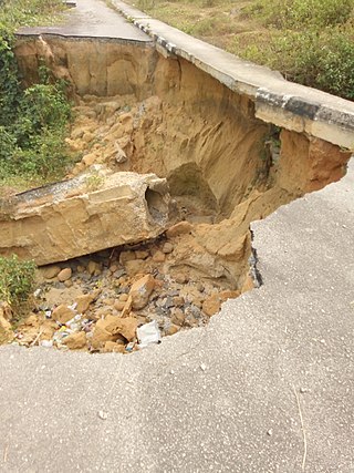
A gully is a landform created by running water, mass movement, or commonly a combination of both eroding sharply into soil or other relatively erodible material, typically on a hillside or in river floodplains or terraces. Gullies resemble large ditches or small valleys, but are metres to tens of metres in depth and width, are characterized by a distinct 'headscarp' or 'headwall' and progress by headward erosion. Gullies are commonly related to intermittent or ephemeral water flow, usually associated with localised intense or protracted rainfall events or snowmelt. Gullies can be formed and accelerated by cultivation practices on hillslopes in farmland, and they can develop rapidly in rangelands from existing natural erosion forms subject to vegetative cover removal and livestock activity.

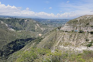
Terrain or relief involves the vertical and horizontal dimensions of land surface. The term bathymetry is used to describe underwater relief, while hypsometry studies terrain relative to sea level. The Latin word terra means "earth."
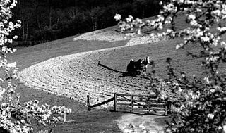
Contour bunding or contour farming or contour ploughing is the farming practice of plowing and/or planting across a slope following its elevation contour lines. These contour lines create a water break which reduces the formation of rills and gullies during times of heavy precipitation, allowing more time for the water to settle into the soil. In contour plowing, the ruts made by the plow run perpendicular rather than parallel to the slopes, generally furrows that curve around the land and are level. This method is also known for preventing tillage erosion. Tillage erosion is the soil movement and erosion by tilling a given plot of land. A similar practice is contour bunding where stones are placed around the contours of slopes. Contour ploughing has been proved to reduce fertilizer loss, power and time consumption, and wear on machines, as well as to increase crop yields and reduces soil erosion.
Drainage density is a quantity used to describe physical parameters of a drainage basin. First described by Robert E. Horton, drainage density is defined as the total length of channel in a drainage basin divided by the total area, represented by the following equation:
Flood forecasting is the process of predicting the occurrence, magnitude, timing, and duration of floods in a specific area, often by analysing various hydrological, meteorological, and environmental factors. The primary goal of flood forecasting is to deliver timely and accurate information to decision-makers, empowering them to take appropriate actions to mitigate the potential consequences of flooding on human lives, property, and the environment. By accounting for the various dimensions of a flood event, such as occurrence, magnitude, duration, and spatial extent, flood forecasting models can offer a more holistic and detailed representation of the impending risks and facilitate more effective response strategies.

Erosion control is the practice of preventing or controlling wind or water erosion in agriculture, land development, coastal areas, river banks and construction. Effective erosion controls handle surface runoff and are important techniques in preventing water pollution, soil loss, wildlife habitat loss and human property loss.

Surface runoff is the unconfined flow of water over the ground surface, in contrast to channel runoff. It occurs when excess rainwater, stormwater, meltwater, or other sources, can no longer sufficiently rapidly infiltrate in the soil. This can occur when the soil is saturated by water to its full capacity, and the rain arrives more quickly than the soil can absorb it. Surface runoff often occurs because impervious areas do not allow water to soak into the ground. Furthermore, runoff can occur either through natural or human-made processes.
The runoff curve number is an empirical parameter used in hydrology for predicting direct runoff or infiltration from rainfall excess. The curve number method was developed by the USDA Natural Resources Conservation Service, which was formerly called the Soil Conservation Service or SCS — the number is still popularly known as a "SCS runoff curve number" in the literature. The runoff curve number was developed from an empirical analysis of runoff from small catchments and hillslope plots monitored by the USDA. It is widely used and is an efficient method for determining the approximate amount of direct runoff from a rainfall event in a particular area.

An hydrological transport model is a mathematical model used to simulate the flow of rivers, streams, groundwater movement or drainage front displacement, and calculate water quality parameters. These models generally came into use in the 1960s and 1970s when demand for numerical forecasting of water quality and drainage was driven by environmental legislation, and at a similar time widespread access to significant computer power became available. Much of the original model development took place in the United States and United Kingdom, but today these models are refined and used worldwide.
The Universal Soil Loss Equation (USLE) is a widely used mathematical model that describes soil erosion processes.
GSSHA is a two-dimensional, physically based watershed model developed by the Engineer Research and Development Center of the United States Army Corps of Engineers. It simulates surface water and groundwater hydrology, erosion and sediment transport. The GSSHA model is used for hydraulic engineering and research, and is on the Federal Emergency Management Agency (FEMA) list of hydrologic models accepted for use in the national flood insurance program for flood hydrograph estimation. Input is best prepared by the Watershed Modeling System interface, which effectively links the model with geographic information systems (GIS).
The Water Erosion Prediction Project (WEPP) model is a physically based erosion simulation model built on the fundamentals of hydrology, plant science, hydraulics, and erosion mechanics. The model was developed by an interagency team of scientists to replace the Universal Soil Loss Equation (USLE) and has been widely used in the United States and the world. WEPP requires four inputs, i.e., climate, topography, soil, and management (vegetation); and provides various types of outputs, including water balance, soil detachment and deposition at points along the slope, sediment delivery, and vegetation growth. The WEPP model has been improved continuously since its public delivery in 1995, and is applicable for a variety of areas.
Erodability is the inherent yielding or nonresistance of soils and rocks to erosion. A high erodibility implies that the same amount of work exerted by the erosion processes leads to a larger removal of material. Because the mechanics behind erosion depend upon the competence and coherence of the material, erodibility is treated in different ways depending on the type of surface that eroded.
River incision is the narrow erosion caused by a river or stream that is far from its base level. River incision is common after tectonic uplift of the landscape. Incision by multiple rivers result in a dissected landscape, for example a dissected plateau. River incision is the natural process by which a river cuts downward into its bed, deepening the active channel. Though it is a natural process, it can be accelerated rapidly by human factors including land use changes such as timber harvest, mining, agriculture, and road and dam construction. The rate of incision is a function of basal shear-stress. Shear stress is increased by factors such as sediment in the water, which increase its density. Shear stress is proportional to water mass, gravity, and WSS:
The Nigerian gully erosion crisis has been underway since before 1980. It is an ecological, environmental, economic, and humanitarian disaster resulting in land degradation, as well as the loss of lives and properties worth millions of dollars. The estimated number of gullies in the country is at 3,000.

The May Sho’ate is a river of the Nile basin. Rising in the mountains of Dogu’a Tembien in northern Ethiopia, it flows southward to empty finally in Giba and Tekezé River.

Tillage erosion is a form of soil erosion occurring in cultivated fields due to the movement of soil by tillage. There is growing evidence that tillage erosion is a major soil erosion process in agricultural lands, surpassing water and wind erosion in many fields all around the world, especially on sloping and hilly lands A signature spatial pattern of soil erosion shown in many water erosion handbooks and pamphlets, the eroded hilltops, is actually caused by tillage erosion as water erosion mainly causes soil losses in the midslope and lowerslope segments of a slope, not the hilltops. Tillage erosion results in soil degradation, which can lead to significant reduction in crop yield and, therefore, economic losses for the farm.
References
- Jetten V. and Favis-Mortlock, D.T. 2006. Modelling Soil Erosion in Europe. In, Boardman, J. and Poesen, J. (eds) Soil Erosion In Europe. Wiley.
- McKenna, G.T., 2002. Sustainable mine reclamation and landscape engineering. PhD Thesis, University of Alberta, Edmonton, 661 pp.