
Yggdrasil is an immense and central sacred tree in Norse cosmology. Around it exists all else, including the Nine Worlds.

Cumbria is a ceremonial county in North West England. It borders the Scottish council areas of Dumfries and Galloway and Scottish Borders to the north, Northumberland and County Durham to the east, North Yorkshire to the south-east, Lancashire to the south, and the Irish Sea to the west. Its largest settlement is the city of Carlisle.

The Derwent is a famous river in the county of Cumbria in the north of England; it rises in the Lake District and flows northwards through two of its principal lakes, before turning sharply westward to enter the Irish Sea at Workington
Cumbric was a variety of the Common Brittonic language spoken during the Early Middle Ages in the Hen Ogledd or "Old North" in what is now the counties of Westmorland, Cumberland, northern Lancashire in Northern England and the southern Scottish Lowlands, alongside the Kingdom of Elmet in modern day Yorkshire. It was closely related to Old Welsh and the other Brittonic languages. Place name evidence suggests Cumbric may also have been spoken as far south as Pendle and the Yorkshire Dales. The prevailing view is that it became extinct in the 12th century, after the incorporation of the semi-independent Kingdom of Strathclyde into the Kingdom of Scotland.

Coniston Water is a lake in the Lake District in North West England. It is the third largest by volume, after Windermere and Ullswater, and the fifth-largest by area. The lake has a length of 8.7 kilometres, a maximum width of 730 metres (800 yd), and a maximum depth of 56.1 m. Its outflow is the River Crake, which drains into Morecambe Bay via the estuary of the River Leven. The lake is in the unitary authority of Westmorland and Furness, and the ceremonial county of Cumbria.

Grasmere is a village and former civil parish, now in the parish of Lakes, in the Westmorland and Furness district of Cumbria, England, and situated in the centre of the Lake District and named after its adjacent lake. Grasmere lies within the historic county of Westmorland. The Ambleside and Grasmere ward had an estimated population of 4,592 in 2019. William and Dorothy Wordsworth, the 'Lake Poets', lived in Grasmere for 14 years and called it "the loveliest spot that man hath ever found."

Bassenthwaite Lake is a body of water in the Lake District in North West England, near the town of Keswick. It has an area of 5.3 km2 (2.0 sq mi), making the fourth largest of the lakes in the region. The lake has a length of approximately 4 miles (6.4 km) long and maximum width of 0.75 miles (1 km), a maximum depth of 19 m (62 ft), and a surface elevation of 68 m (223 ft) above sea level. Its primary inflow and outflow is the River Derwent, which drains into the Irish Sea at Workington. The lake is in the unitary authority of Cumberland, and the ceremonial county of Cumbria.

Ullswater is a glacial lake in Cumbria, England and part of the Lake District National Park. It is the second largest lake in the region by both area and volume, after Windermere. The lake is about 7 miles (11 km) long, 0.75 miles (1 km) wide, and has a maximum depth of 63 metres (207 ft). Its outflow is River Eamont, which meets the River Eden at Brougham Castle before flowing into the Solway Firth. The lake is in the administrative county of Westmorland and Furness and the ceremonial county of Cumbria.
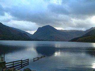
Buttermere is a lake in the Lake District in North West England. It has a length of approximately 2 kilometres (1.2 mi) and a maximum width of 0.54 kilometres (0.34 mi), an area of 0.9 square kilometres (0.35 sq mi), a maximum depth of 28.6 metres (94 ft), and a surface elevation of 100.3 metres (329 ft) above sea level. Its primary outflow is Buttermere Dubs, a short stream which connects the lake to Crummock Water. From Crummock Water the River Cocker flows to Cockermouth, where it joins the River Derwent and finally enters the Irish Sea at Workington. The lake is in the unitary authority of Cumberland, and the ceremonial county of Cumbria.

Furness is a peninsula and region of Cumbria, England. Together with the Cartmel Peninsula it forms North Lonsdale, historically an exclave of Lancashire. On 1 April 2023 it became part of the new unitary authority of Westmorland and Furness.

Lorton, a parish in Cumberland, Cumbria, England, consists of two adjacent villages: Low Lorton and High Lorton. Both nestle at the northern end of the Vale of Lorton, surrounded by fells such as Grasmoor, Hopegill Head and Whiteside. They are about 4 miles (6.5 km) from Cockermouth, which gives access to the main A66 road. Other nearby places include Loweswater and Brigham.

Coniston is a village and civil parish in the Westmorland and Furness district of Cumbria, England. In the 2001 census the parish had a population of 1,058, decreasing at the 2011 census to 928. Within the boundaries of the historic county of Lancashire, it is in the southern part of the Lake District National Park, between Coniston Water, the third longest lake in the Lake District, and Coniston Old Man.

Bassenthwaite is a village and civil parish to the west of Bassenthwaite Lake in Cumbria, historically part of Cumberland, within the Lake District National Park, England. According to the 2001 census it had a population of 412, increasing to 481 at the 2011 Census. There is a Church of England Church, St John's Bassenthwaite and a tiny Methodist chapel. The village contains many elements of the archetypal English village including a green, primary school and a stream that runs through it.

Rydal Water is a small body of water in the central part of the English Lake District, in the county of Cumbria. It is located near the hamlet of Rydal, between Grasmere and Ambleside in the Rothay Valley.

Cumbrian toponymy refers to the study of place names in Cumbria, a county in North West England, and as a result of the spread of the ancient Cumbric language, further parts of northern England and the Southern Uplands of Scotland.
The history of Cumbria as a county of England begins with the Local Government Act 1972. Its territory and constituent parts however have a long history under various other administrative and historic units of governance. Cumbria is an upland, coastal and rural area, with a history of invasions, migration and settlement, as well as battles and skirmishes between the English and the Scots.

Gowbarrow Fell is a low fell in the English Lake District. It is an outlier of the Eastern Fells, standing to the north of Ullswater, bounded on one side by Aira Beck with its waterfall Aira Force. The waterfall is a popular attraction for visitors to the area.

Grasmere is one of the smaller lakes of the English Lake District, in the county of Cumbria. It gives its name to the village of Grasmere, famously associated with the poet William Wordsworth, which lies immediately to the north of the lake.

Seathwaite is a village in the Dunnerdale-with-Seathwaite civil parish in the Westmorland and Furness district of Cumbria in North West England. It is in the Lake District and part of historic Lancashire. The parish has a population of 129. The village's name comes from old Norse words sef (sedges) and thveit (clearing) and may be taken to mean "Sedges clearing"; written records from 1340 spell the village as Seuthwayt.


