
Tenkiller Ferry Lake, or more simply, "Lake Tenkiller," is a reservoir in eastern Oklahoma formed by the damming of the Illinois River. The earth-fill dam was constructed between 1947 and 1952 by the United States Army Corps of Engineers for purposes of flood control, hydroelectric power generation, water supply and recreation. It went into full operation in 1953. The lake and dam were named for the Tenkiller family, prominent Cherokees who owned the land and ferry that were bought for the project. This is 6th largest lake in Oklahoma, based on water capacity.

Keystone Lake is a reservoir in northeastern Oklahoma on the Arkansas and Cimarron rivers. It is located upstream about 23 miles (37 km) from Tulsa. It was created in 1968 when the Keystone Dam was completed. The primary purposes are: flood control, hydroelectric power generation, wildlife management and recreation.
Lake Eufaula, sometimes referred to as Eufaula Lake, is a reservoir in Oklahoma. It is located on the Canadian River, 27 mi (43 km) upstream from its confluence with the Arkansas River and near the town of Eufaula. The lake covers parts of McIntosh County, Pittsburg, Haskell and Okmulgee counties and drains 47,522 square miles (123,080 km2). Water sources include the Canadian, North Fork Canadian and Deep Fork rivers. It is the largest-capacity lake in the state of Oklahoma with a volume of 2,099,000 acre feet (2.589×10⁹ m3), a surface area of 102,000 acres (410 km2) and 600 miles (970 km) of shoreline.

Big Bend Dam is a major embankment rolled-earth dam on the Missouri River in Central South Dakota, United States, creating Lake Sharpe. The dam was constructed by the U.S. Army Corps of Engineers as part of the Pick-Sloan Plan for Missouri watershed development authorized by the Flood Control Act of 1944. Construction began in 1959 and the embankment was completed in July 1963. Power generation began at the facility in 1964 and the entire complex was completed in 1966 at a total cost of $107 million. The hydroelectric plant generates 493,300 kilowatts of electricity at maximum capacity, with an annual production of 969 million kilowatt hours, and meets peak-hour demand for power within the Missouri River Basin.

Lake Allatoona is a U.S. Army Corps of Engineers reservoir on the Etowah River in northwestern part of the State of Georgia. This reservoir is mostly in southeastern Bartow County and southwestern Cherokee County. A small portion is located in Cobb County near Acworth. Cartersville is the nearest city to Allatoona Dam. Also, Red Top Mountain State Park is located on its shores, on the peninsula between the two arms of the lake. Most of the north side of the lake remains protected from land development because of its isolated location, mostly blocked by the lake.
The Wolf Creek Dam is a multi-purpose dam on the Cumberland River in the western part of Russell County, Kentucky, United States. The dam serves at once four distinct purposes: it generates hydroelectricity; it regulates and limits flooding; it releases stored water to permit year-round navigation on the lower Cumberland River; and it creates Lake Cumberland for recreation, which has become a popular tourist attraction. Because of seepage problems in the dam's foundation, it has become the U.S. Army Corps of Engineers's top dam priority. U.S. Route 127 is built on top of the dam.

Dworshak Dam is a concrete gravity dam in the western United States, on the North Fork Clearwater River in Clearwater County, Idaho. The dam is located approximately four miles (6 km) northwest of Orofino and impounds the Dworshak Reservoir for flood control and hydroelectricity generation. With a height of 717 feet (219 m), Dworshak is the third tallest dam in the United States and the tallest straight-axis concrete dam in the Western Hemisphere. Lacking fish ladders, Dworshak Dam blocks fish passage and completely extirpated anadromous fish migration into the upper reaches of the North Fork Clearwater River and its tributaries in Idaho. Construction of the dam by the U.S. Army Corps of Engineers (USACE) began in 1966 and was completed in 1973.

Carters Dam is an earthen embankment dam located south of Chatsworth in Murray County and west of Ellijay in northwestern Georgia, United States, that creates Carters Lake.

Gavins Point Dam is a 1.9 mi (3 km) long embankment rolled-earth and chalk-fill dam which spans the Missouri River and impounds Lewis and Clark Lake. The dam joins Cedar County, Nebraska with Yankton County, South Dakota a distance of 811.1 river miles (1,305 km) upstream of St. Louis, Missouri, where the river joins the Mississippi River. The dam and hydroelectric power plant were constructed as the Gavins Point Project from 1952 to 1957 by the United States Army Corps of Engineers as part of the Pick-Sloan Plan. The dam is located approximately 4 miles (6.4 km) west or upstream of Yankton, South Dakota.

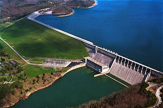
Hartwell Dam is a concrete and embankment dam located on the Savannah River at the border of South Carolina and Georgia, creating Lake Hartwell. The dam was built by the U.S. Army Corps of Engineers between 1955 and 1962 for the purposes of flood control, hydropower and navigation. The concrete and earthen structure spans 15,840 feet (4,828 m). The concrete section is 1,900 feet (579 m) long and rises 204 feet (62 m) above the riverbed at its apex. The Hartwell Dam currently produces 468 million KWh of electricity annually, has prevented over $40 million in flood damage since completion and also provides recreation, water quality, water supply, along with fish and wildlife management.

Optima Lake was built to be a reservoir in Texas County, Oklahoma. The site is located just north of Hardesty and east of Guymon in the Oklahoma Panhandle.

Terminus Dam is a dam on the Kaweah River in Tulare County, California in the United States, located near Three Rivers about 15 mi (24 km) from the western boundary of Sequoia National Park and 20 mi (32 km) east of Visalia. The dam forms Lake Kaweah for flood control and irrigation water supply. Completed by the U.S. Army Corps of Engineers (USACE) in 1962, Terminus is an earthfill dam 255 ft (78 m) high and 2,375 ft (724 m) long. The reservoir has a maximum capacity of 185,600 acre⋅ft (0.2289 km3) of water, although it usually sits at much lower levels.

Denison Dam, also known as Lake Texoma Dam, is a dam located on the Red River between Texas and Oklahoma that impounds Lake Texoma. The purpose of the dam is flood control, water supply, hydroelectric power production, river regulation, navigation and recreation. It was also designated by the American Society of Civil Engineers as a National Historic Civil Engineering Landmark in 1993.

Lake Oologah is a reservoir in northeastern Oklahoma. It is located near the towns of Oologah, Nowata, and Claremore. The lake has a surface of 29,500 acres (119 km2) of water and 209 miles (336 km) of shoreline with 11 lake-side parks. The water storage capacity is rated as 552,210 acre feet (681,140,000 m3). The lake is formed along the Verdigris River, and is a source of water for the Tulsa Metropolitan Area. The purpose of the dam and lake is flood control, water supply, navigation, recreation, and fish and wildlife.

Richard B. Russell Dam is a concrete-gravity and embankment dam located on the Savannah River at the border of South Carolina and Georgia, creating Richard B. Russell Lake. The dam was built by the U.S. Army Corps of Engineers between 1974 and 1985 for the purposes of flood control, hydroelectricity, recreation, additional stream flow regulation, water supply, and fish and wildlife management. The concrete structure of the dam spans 1,904 feet (580 m) and rises 210 feet (64 m) above the riverbed, housing a hydro-power plant with an installed 600 megawatts (800,000 hp) capacity. The Richard B. Russell Dam is the final large dam completed by the U.S. Army Corps in the Savannah River Basin and lies 30 miles downstream from the Hartwell Dam (1962) and 37 miles (60 km) upstream from the J. Strom Thurmond Dam (1954).

The Pensacola Dam, also known as the Grand River Dam, is a multiple-arch buttress dam on the Grand River in-between Disney and Langley in the U.S. state of Oklahoma. The dam is operated by the Grand River Dam Authority and creates Grand Lake o' the Cherokees. After decades of vision and planning, it was constructed between 1938 and 1940 for the purposes of hydroelectric power generation, flood control and recreation. It is Oklahoma's first hydroelectric power plant and is referred to as the longest multiple-arch dam in the world.

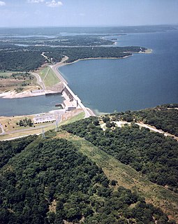
The Fort Gibson Dam is a gravity dam on the Grand (Neosho) River in Oklahoma, 5.4 mi (9 km) north of the town of Fort Gibson. The dam forms Fort Gibson Lake. The primary purposes of the dam and lake are flood control and hydroelectric power production, although supply of drinking water to local communities, as well as recreation, are additional benefits. The project was authorized by the Flood Control Act of 1941 and construction began the next year. During World War II construction was suspended and it recommenced in May 1946. In June 1949, the river was closed and the entire project was complete in September 1953 with the operation of the last of the power plant's four generators. Rights to construct the project originally belonged to the Grand River Dam Authority, but were seized by the U.S. Army Corps of Engineers in 1946.

Abiquiu Dam is a dam on the Rio Chama, located about 60 miles (97 km) northwest of Santa Fe in Rio Arriba County, New Mexico. Built and operated by the U.S. Army Corps of Engineers (USACE), the dam is an earth embankment structure 354 feet (108 m) high and 1,800 feet (550 m) long, containing 11.8 million cubic yards of fill. The dam forms Abiquiu Lake, one of the largest lakes in New Mexico with a full storage capacity of 1,369,000 acre feet (1,689,000 dam3) and 5,200 acres (2,100 ha) of water. To date, the reservoir has never filled to capacity, with a record high of 402,258 acre feet (496,178 dam3), 29.4% of full pool, on June 22, 1987. The dam's primary purpose is flood control, in addition to irrigation and municipal water storage, and hydroelectric generation.
Conemaugh Dam is a concrete gravity dam across the Conemaugh River, near the town of Saltsburg, in Pennsylvania. The dam was authorized by the Flood Control Act of 1936 and completed in 1952 by the U.S. Army Corps of Engineers for flood protection on the Conemaugh, Kiskiminetas, and Allegheny Rivers. The dam is one of 16 flood control structures in the Corps' Pittsburgh District.


