Fairton, New Jersey

Last updated

Fairton, New Jersey
Cumberland County New Jersey Incorporated and Unincorporated areas Fairton Highlighted.svg
Map of Fairton highlighted within Cumberland County. Right: Location of Cumberland County in New Jersey.
Location map of Cumberland County, New Jersey.svg
Red pog.svg
Fairton
Location in Cumberland County
USA New Jersey relief location map.svg
Red pog.svg
Fairton
Location in New Jersey
Usa edcp relief location map.png
Red pog.svg
Fairton
Location in the United States
Coordinates: 39°22′24″N75°12′32″W / 39.373352°N 75.208845°W / 39.373352; -75.208845
Country Flag of the United States.svg  United States
State Flag of New Jersey.svg  New Jersey
County Cumberland
Township Fairfield
Area
[1]
  Total2.99 sq mi (7.73 km2)
  Land2.87 sq mi (7.43 km2)
  Water0.12 sq mi (0.30 km2)  4.29%
Elevation
[2]
26 ft (8 m)
Population
 (2020) [3]
  Total1,060
  Density369.47/sq mi (142.65/km2)
Time zone UTC−05:00 (Eastern (EST))
  Summer (DST) UTC−04:00 (Eastern (EDT))
ZIP Code
08320 [4] [5]
Area code 856
FIPS code 34-22530 [6] [7]
GNIS feature ID02389066 [8]

Fairton is an unincorporated community and census-designated place (CDP) [9] located within Fairfield Township, in Cumberland County, in the U.S. state of New Jersey. [10] It is part of the Vineland-Millville-Bridgeton Primary Metropolitan Statistical Area for statistical purposes. As of the 2010 United States Census, the CDP's population was 1,264. [11]

Contents

History

This area was occupied historically by the Lenape and Nanticoke peoples, both part of the Algonquian languages family of the Atlantic coast. Their territory was encroached on by European-American settlers from colonial times.

The first industry in Fairfield was a mill, established by English settler Samuel Fithian. He owned part of the Grist Mill on Forke Creek before 1702. No information has been discovered on the other owners, but the shares were probably held in common. At some time before 1763, the owners moved the mill dam to near Clarks Pond Road. The mill was owned by David Clark from 1759 to 1843.

In the 1810s, a pork and beef business was the principal industry in this area. In the center of town was a busy public wharf, from which were shipped vegetables, fish and lumber to large city markets. Fairton was also active in the boat-building industry; between 1850 and 1897, its yards built three sloops. [12]

In 1978, the indigenous peoples based in Cumberland County reorganized as the Nanticoke Lenni-Lenape Tribal Nation. Their cultural center is based in Fairton, and their tribal headquarters in Bridgeton. [13] The tribe said that in 2016 they had 3,000 enrolled members, whose membership is based on documented descent from core families and blood quantum. The tribe has not obtained federal recognition. They contend that a state resolution recognized them, but in March 2016 a state court of New Jersey said that the state has not officially recognized any American Indian tribe in its territory and had no process to do so. [14] [15] Tribal members have lived for centuries in Cumberland and Salem counties in present-day New Jersey. [13]

Geography

According to the United States Census Bureau, the CDP had a total area of 2.988 square miles (7.739 km2), including 2.860 square miles (7.407 km2) of land and 0.128 square mile (0.332 km2) of water (4.29%). [16] [17]

Demographics

Historical population
CensusPop.Note
1990 1,359
2000 2,25365.8%
2010 1,264−43.9%
2020 1,060−16.1%
Population sources:
2000 [18] 2010 [11] 2020 [3]

2010 census

The 2010 United States census counted 1,264 people, 529 households, and 354 families in the CDP. The population density was 442.0 per square mile (170.7/km2). There were 573 housing units at an average density of 200.4 per square mile (77.4/km2). The racial makeup was 71.76% (907) White, 12.82% (162) Black or African American, 4.83% (61) Native American, 0.71% (9) Asian, 0.00% (0) Pacific Islander, 4.03% (51) from other races, and 5.85% (74) from two or more races. Hispanic or Latino of any race were 8.07% (102) of the population. [11]

Of the 529 households, 23.4% had children under the age of 18; 45.4% were married couples living together; 16.3% had a female householder with no husband present and 33.1% were non-families. Of all households, 28.4% were made up of individuals and 12.7% had someone living alone who was 65 years of age or older. The average household size was 2.39 and the average family size was 2.90. [11]

20.1% of the population were under the age of 18, 8.7% from 18 to 24, 23.3% from 25 to 44, 29.4% from 45 to 64, and 18.6% who were 65 years of age or older. The median age was 43.7 years. For every 100 females, the population had 92.7 males. For every 100 females ages 18 and older there were 89.1 males. [11]

2000 census

As of the 2000 United States Census [6] there were 2,253 people, 474 households, and 334 families residing in the CDP. The population density was 308.5/km2 (798.7/mi2). There were 511 housing units at an average density of 70.0/km2 (181.1/mi2). The racial makeup of the CDP was 61.43% White, 33.38% African American, 2.35% Native American, 1.20% Asian, 0.18% from other races, and 1.46% from two or more races. Hispanic or Latino of any race were 11.54% of the population. [18]

There were 474 households, out of which 26.8% had children under the age of 18 living with them, 53.0% were married couples living together, 11.8% had a female householder with no husband present, and 29.5% were non-families. 24.9% of all households were made up of individuals, and 11.4% had someone living alone who was 65 years of age or older. The average household size was 2.46 and the average family size was 2.92. [18]

In the CDP the population was spread out, with 11.5% under the age of 18, 9.0% from 18 to 24, 48.0% from 25 to 44, 23.3% from 45 to 64, and 8.3% who were 65 years of age or older. The median age was 36 years. For every 100 females, there were 265.7 males. For every 100 females age 18 and over, there were 313.9 males. [18]

The median income for a household in the CDP was $37,962, and the median income for a family was $41,000. Males had a median income of $30,750 versus $25,326 for females. The per capita income for the CDP was $20,005. About 3.1% of families and 5.9% of the population were below the poverty line, including 4.6% of those under age 18 and none of those age 65 or over. [18]

Notable people

People who were born in, residents of, or otherwise closely associated with Fairton include:

Related Research Articles

<span class="mw-page-title-main">Cumberland County, New Jersey</span> County in New Jersey

Cumberland County is a coastal county located on the Delaware Bay in the Southern Shore Region of the U.S. state of New Jersey. As of the 2020 census, the county was the state's 16th-most-populous county, with a population of 154,152, a decrease of 2,746 (−1.8%) from the 2010 census count of 156,898. Its county seat is Bridgeton. Cumberland County is named for Prince William, Duke of Cumberland. The county was formally created from portions of Salem County on January 19, 1748. The county is part of the South Jersey region of the state.

<span class="mw-page-title-main">Pemberton Heights, New Jersey</span> Populated place in Burlington County, New Jersey, US

Pemberton Heights is an unincorporated community and census-designated place (CDP) located within Pemberton Township, in Burlington County, in the U.S. state of New Jersey. As of the 2010 United States Census, the CDP's population was 2,423.

<span class="mw-page-title-main">Greentree, New Jersey</span> Populated place in Camden County, New Jersey, US

Greentree is an unincorporated community and census-designated place (CDP) located within Cherry Hill Township, in Camden County, in the U.S. state of New Jersey. As of the 2010 United States Census, the CDP's population was 11,367.

<span class="mw-page-title-main">Bridgeton, New Jersey</span> City in Cumberland County, New Jersey, US

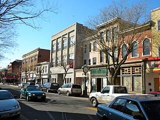
Bridgeton is a city in Cumberland County, within the U.S. state of New Jersey. It is the county seat of Cumberland County and is located on the Cohansey River near Delaware Bay in the South Jersey region of the state.

<span class="mw-page-title-main">Cedarville, New Jersey</span> Populated place in Cumberland County, New Jersey, US

Cedarville is an unincorporated community and census-designated place (CDP) located within Lawrence Township, in Cumberland County, in the U.S. state of New Jersey. It is part of the Vineland-Millville-Bridgeton Primary Metropolitan Statistical Area for statistical purposes. As of the 2020 United States census, the CDP's population was 702.

<span class="mw-page-title-main">Deerfield Township, New Jersey</span> Borough in Cumberland County, New Jersey, US

Deerfield Township is a township in Cumberland County, in the U.S. state of New Jersey. It is part of the Vineland--Bridgeton metropolitan statistical area, which encompasses those cities and all of Cumberland County for statistical purposes and which constitutes a part of the Delaware Valley. As of the 2020 United States census, the township's population was 3,136, an increase of 17 (+0.5%) from the 2010 census count of 3,119, which in turn reflected an increase of 192 (+6.6%) from the 2,927 counted in the 2000 census.

<span class="mw-page-title-main">Downe Township, New Jersey</span> Township in Cumberland County, New Jersey, US

Downe Township is a township in Cumberland County, in the U.S. state of New Jersey. It is part of the Vineland-Bridgeton metropolitan statistical area for statistical purposes. As of the 2020 United States census, the township's population was 1,399, a decrease of 186 (−11.7%) from the 2010 census count of 1,585, which in turn reflected decline of 46 (−2.8%) from the 1,631 counted in the 2000 census.

<span class="mw-page-title-main">Fairfield Township, Cumberland County, New Jersey</span> Township in Cumberland County, New Jersey, US

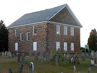
Fairfield Township is a township in Cumberland County, in the U.S. state of New Jersey. It is part of the Vineland-Bridgeton metropolitan statistical area, which encompasses all of Cumberland County for statistical purposes and which constitutes a part of the Delaware Valley. As of the 2020 United States census, the township's population was 5,546, a decrease of 749 (−11.9%) from the 2010 census count of 6,295, which in turn reflected an increase of 12 (+0.2%) from the 6,283 counted in the 2000 census.

<span class="mw-page-title-main">Laurel Lake, New Jersey</span> Populated place in Cumberland County, New Jersey, US

Laurel Lake is an unincorporated community and census-designated place (CDP) located within Commercial Township, in Cumberland County, in the U.S. state of New Jersey. It is part of the Vineland-Millville-Bridgeton Primary Metropolitan Statistical Area for statistical purposes. As of the 2010 United States Census, the CDP's population was 2,989.

<span class="mw-page-title-main">Lawrence Township, Cumberland County, New Jersey</span> Township in Cumberland County, New Jersey, US

Lawrence Township is a township in Cumberland County, in the U.S. state of New Jersey. It is part of the Vineland-Bridgeton metropolitan statistical area for statistical purposes. As of the 2020 United States census, the township's population was 3,087, a decrease of 203 (−6.2%) from the 2010 census count of 3,290, which in turn reflected an increase of 569 (+20.9%) from the 2,721 counted in the 2000 census.

<span class="mw-page-title-main">Port Norris, New Jersey</span> Populated place in Cumberland County, New Jersey, US

Port Norris is an unincorporated community and census-designated place (CDP) located within Commercial Township, in Cumberland County, in the U.S. state of New Jersey. It is part of the Vineland-Millville- Bridgeton Primary Metropolitan Statistical Area for statistical purposes. As of the 2000 United States Census, the CDP's population was 1,377. Legislation was passed in 1911 allowing voters to choose to incorporate Port Norris as a borough, independent from Commercial Township, but it was defeated in a referendum.

<span class="mw-page-title-main">Rosenhayn, New Jersey</span> Populated place in Cumberland County, New Jersey, US

Rosenhayn is an unincorporated community and census-designated place (CDP) located within Deerfield Township, in Cumberland County, in the U.S. state of New Jersey. It is part of the Vineland-Millville- Bridgeton Primary Metropolitan Statistical Area for statistical purposes. As of the 2010 United States Census, the CDP's population was 1,098.

<span class="mw-page-title-main">Seabrook Farms, New Jersey</span> Populated place in Cumberland County, New Jersey, US

Seabrook Farms is an unincorporated community and census-designated place (CDP) located within Seabrook, which is in turn located in Upper Deerfield Township, in Cumberland County, in the U.S. state of New Jersey. It is part of the Vineland-Bridgeton metropolitan statistical area for statistical purposes. At the 2010 census, Seabrook Farms's population was 1,484. Seabrook Farms is named after Charles F. Seabrook, a businessman who ran a truck farm that was one of the state's largest.

<span class="mw-page-title-main">Williamstown, New Jersey</span> Populated place in Gloucester County, New Jersey, US

Williamstown is an unincorporated community and census-designated place (CDP) located in Monroe Township in Gloucester County, in the U.S. state of New Jersey. As of the 2010 U.S. census, Williamstown's population was 15,567.

<span class="mw-page-title-main">Brownville, New Jersey</span> Populated place in Middlesex County, New Jersey, US

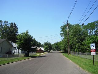
Brownville is an unincorporated community and census-designated place (CDP) located within Old Bridge Township in Middlesex County in the U.S. state of New Jersey. As of the 2010 United States Census, the CDP's population was 2,383.

<span class="mw-page-title-main">Cranbury (CDP), New Jersey</span> Populated place in Middlesex County, New Jersey, US

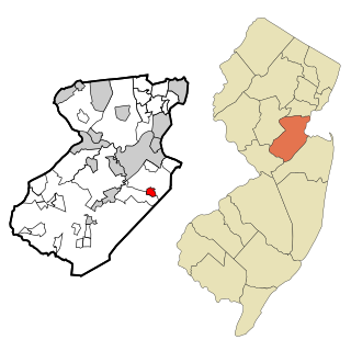
Cranbury is an unincorporated community and census-designated place (CDP) located within Cranbury Township, in Middlesex County, in the U.S. state of New Jersey. As of the 2010 United States Census, the CDP's population was 2,181. Despite the similarity in the name of Cranbury Township and the CDP, the two are not one and the same, as had been the case for most paired Township / CDP combinations prior to the 2010 Census, in which the CDP was coextensive with a township of the same name.

<span class="mw-page-title-main">Princeton Meadows, New Jersey</span> Populated place in Middlesex County, New Jersey, US

Princeton Meadows is an unincorporated community and census-designated place (CDP) located within Plainsboro Township, in Middlesex County, in the U.S. state of New Jersey. As of the 2010 United States Census, the CDP's population was 13,834.

<span class="mw-page-title-main">Allenwood, New Jersey</span> Populated place in Monmouth County, New Jersey, US

Allenwood is an unincorporated community and census-designated place (CDP) located within Wall Township, in Monmouth County, in the U.S. state of New Jersey. As of the 2010 United States Census, the CDP's population was 925.

<span class="mw-page-title-main">Crestwood Village, New Jersey</span> CDP in Ocean County, New Jersey, US

Crestwood Village is an unincorporated community and census-designated place (CDP) located within Manchester Township, in Ocean County, in the U.S. state of New Jersey. As of the 2010 United States Census, the CDP's population was 7,907.

<span class="mw-page-title-main">Silver Ridge, New Jersey</span> Populated place in Ocean County, New Jersey, US

Silver Ridge is an unincorporated community and census-designated place (CDP) located within Berkeley Township, in Ocean County, in the U.S. state of New Jersey. As of the 2010 United States Census, the CDP's population was 1,133.

References

  1. "ArcGIS REST Services Directory". United States Census Bureau. Retrieved October 11, 2022.
  2. U.S. Geological Survey Geographic Names Information System: Fairton Census Designated Place, Geographic Names Information System. Accessed November 2, 2012.
  3. 1 2 Census Data Explorer: Fairton CDP, New Jersey, United States Census Bureau. Accessed June 15, 2023.
  4. Look Up a ZIP Code for Fairton, NJ, United States Postal Service. Accessed November 2, 2012.
  5. Zip Codes, State of New Jersey. Accessed August 28, 2013.
  6. 1 2 U.S. Census website, United States Census Bureau. Accessed September 4, 2014.
  7. Geographic Codes Lookup for New Jersey, Missouri Census Data Center. Accessed June 9, 2023.
  8. US Board on Geographic Names, United States Geological Survey. Accessed September 4, 2014.
  9. State of New Jersey Census Designated Places - BVP20 - Data as of January 1, 2020, United States Census Bureau. Accessed December 1, 2022.
  10. New Jersey: 2010 - Population and Housing Unit Counts - 2010 Census of Population and Housing (CPH-2-32), United States Census Bureau, August 2012. Accessed October 18, 2012.
  11. 1 2 3 4 5 DP-1 - Profile of General Population and Housing Characteristics: 2010 Demographic Profile Data for Fairton CDP, New Jersey Archived 2020-02-12 at archive.today , United States Census Bureau. Accessed November 2, 2012.
  12. Conahey Sr., Patrick W. "A look back at history of Fairton", Cumberland County Voices, September 29, 2009. Accessed September 18, 2016.
  13. 1 2 "Meet Native America: Mark Gould, Chief of the Nanticoke Lenni-Lenape Tribal Nation" Archived September 9, 2017, at the Wayback Machine , National Museum of the American Indian, September 6, 2016. Accessed September 18, 2016. "Our tribal headquarters is located in Bridgeton, in Cumberland County, New Jersey. Our cultural center is located on 51 acres in Fairton, in Cumberland County. Most of our tribal members live and have always lived in Cumberland and Salem counties."
  14. "New Jersey judge dismisses lawsuit to recognize American Indian tribes", KYW-TV, March 9, 2016. Accessed September 18, 2016.
  15. O'Sullivan, Jeannie. "New Jersey never formally recognized tribe, judge rules", Law 360, March 9, 2016. Accessed September 18, 2016.
  16. Gazetteer of New Jersey Places, United States Census Bureau. Accessed July 21, 2016.
  17. US Gazetteer files: 2010, 2000, and 1990, United States Census Bureau. Accessed September 4, 2014.
  18. 1 2 3 4 5 DP-1 - Profile of General Demographic Characteristics: 2000 from the Census 2000 Summary File 1 (SF 1) 100-Percent Data for Fairton CDP, New Jersey Archived 2020-02-12 at archive.today , United States Census Bureau. Accessed November 2, 2012.
  19. "Nathaniel Clark Burt", American Writers and Compilers of Sacred Music. Accessed August 28, 2013. "Nathaniel Clark Burt, born in Fairton, New Jersey, April 23, 1825, graduated from Princeton in 1846, and from its theological seminary three years later."
  20. John Thompson Nixon, Biographical Directory of the United States Congress . Accessed August 24, 2007.