Related Research Articles
The Geographic Names Information System (GNIS) is a database of name and location information about more than two million physical and cultural features throughout the United States and its territories, Antarctica, and the associated states of the Marshall Islands, Federated States of Micronesia, and Palau. It is a type of gazetteer. It was developed by the United States Geological Survey (USGS) in cooperation with the United States Board on Geographic Names (BGN) to promote the standardization of feature names.

The Kentucky River is a tributary of the Ohio River, 260 miles (418 km) long, in the U.S. Commonwealth of Kentucky. The river and its tributaries drain much of the central region of the state, with its upper course passing through the coal-mining regions of the Cumberland Mountains, and its lower course passing through the Bluegrass region in the north central part of the state. Its watershed encompasses about 7,000 square miles (18,000 km2). It supplies drinking water to about one-sixth of the population of the Commonwealth of Kentucky.

The Youghiogheny River, or the Yough for short, is a 134-mile-long (216 km) tributary of the Monongahela River in the U.S. states of West Virginia, Maryland, and Pennsylvania. It drains an area on the west side of the Allegheny Mountains northward into Pennsylvania, providing a small watershed in extreme western Maryland into the tributaries of the Mississippi River. Youghiogheny is a Lenape word meaning "a stream flowing in a contrary direction".

The Appomattox River is a tributary of the James River, approximately 157 miles (253 km) long, in central and eastern Virginia, named for the Appomattocs Indian tribe who lived along its lower banks in the 17th century. It drains a cotton and tobacco-growing region of the Piedmont and coastal plain southwest of Richmond.

The Dan River flows 214 miles (344 km) in the U.S. states of North Carolina and Virginia. It rises in Patrick County, Virginia, and crosses the state border into Stokes County, North Carolina. It then flows into Rockingham County. From there it flows back into Virginia through Pittsylvania County before reentering North Carolina near the border between Caswell County and Rockingham County. It flows into northern Caswell County and then back into southern Virginia and finally into Kerr Reservoir on the Roanoke River.
Largent is an unincorporated community village located chiefly in Morgan County and partly in Hampshire County in the U.S. state of West Virginia. Largent is located on the Cacapon River, approximately 18 miles southwest of Berkeley Springs along Cacapon Road. It is located by Old Enon Cemetery, Stony Creek, and the Cacapon River. Largent's original town name was Enon. It was most likely renamed when Postal Service found another town of Enon elsewhere in the state. The Enon name is found in local church and cemetery names. The Enon school is found on USGS maps from 1914 through 1923. The school has been open at least since the 1930s. The Baileys bought the building in 1958 and it has been a residence since.
The Banister River is a tributary of the Dan River, about 65 mi (105 km) long, in southern Virginia in the United States. Via the Dan, it is part of the watershed of the Roanoke River, which flows to the Atlantic Ocean. It rises on Brier Mountain in western Pittsylvania County and flows generally eastwardly into Halifax County, past the town of Halifax. It joins the Dan River 6 mi (9.7 km) east of the town of South Boston.
Abrams Creek is an 11.2-mile-long (18.0 km) tributary stream of Opequon Creek in Frederick County and the independent city of Winchester in Virginia. Abrams Creek rises north of Round Hill and flows in a southeasterly direction through Winchester. From Winchester, Abrams Creek flows east into Opequon Creek. The stream was originally known as Abraham's Creek.
The Mayo River is a tributary of the Dan River, which in turn is a tributary of the Roanoke River. All three rivers flow through the U.S. states of Virginia and North Carolina. It is named for Major William Mayo.

The Greenbrier River Watershed Association (GRWA) is one of the oldest watershed associations in the state of West Virginia, founded in 1990. It has supported the creation of other watershed associations throughout the state and maintains a policy of "upstream courtesy" and "downstream courtesy" with its neighbors.

Craig Creek is an 84-mile-long (135 km) tributary of the James River in the U.S. state of Virginia. It flows through the Ridge-and-Valley Appalachians in western Virginia, passing 15 miles (24 km) northwest of Roanoke.
The Little Nottoway River is a 14.31 mi (23.03 km) long tributary to the Nottoway River in the United States state of Virginia. Located in the southeastern part of the state, it is part of the larger Chowan-Albemarle drainage.
The Middle River is a 70.6-mile-long (113.6 km) river in the U.S. state of Virginia. Flowing entirely within Augusta County, the Middle River joins the North River, which in turn meets the South River at Port Republic to form the South Fork Shenandoah River.
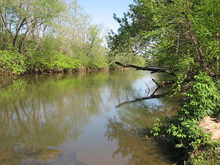
Reed Creek is a tributary to the Smith River in the United States state of Virginia. Reed Creek is in the Streams category for Henry County, Virginia. Reed Creek is displayed on the Martinsville West USGS quad topo map for Martinsville, Virginia. The latitude and longitude coordinates of Reed Creek are 36.7220815, -79.9392072 and the approximate elevation is 722 feet above sea level. Reed Creek is also displayed on the USGS quad maps for Bassett, Virginia and Snow Creek, Virginia.
The Russell Fork is a 51.9-mile-long (83.5 km) tributary of the Levisa Fork in southwestern Virginia and southeastern Kentucky in the United States. Known for its whitewater, it rises in the Appalachian Mountains of southwest Virginia, in southern Buchanan County at the base of Big A Mountain, and flows northwest into Dickenson County. The Russell Fork continues to flow through the town of Haysi, Virginia, the Breaks Interstate Park, and the town of Elkhorn City, Kentucky, in Pike County, to the community of Millard, Kentucky where it flows into the Levisa Fork which, together with the Tug Fork, form the Big Sandy River.
Sandy Creek is a river in the United States state of Virginia. It is a tributary of the Banister River.
Sandy River is a 12.9-mile-long (20.8 km) tributary of the Bush River in the U.S. state of Virginia. Via the Bush River and the Appomattox River, it is part of the James River watershed. It rises in Prince Edward County northeast of the village of Green Bay and flow north through Prince Edward State Forest and farmland, joining the Bush River less than one mile south of that river's confluence with the Appomattox near the town of Farmville.
Brink is a ghost town in Greenbrier County, West Virginia, United States. Brink was located on the Greenbrier River 4 miles (6.4 km) northwest of White Sulphur Springs. Brink appeared on USGS maps as late as 1923.
Whitcomb is a ghost town in Greenbrier County, West Virginia, United States. Whitcomb was located on the Greenbrier River 1.5 miles (2.4 km) east of Fairlea. Whitcomb appeared on USGS maps as late as 1935.

Buffalo Creek is a stream which runs through the United States commonwealths of Pennsylvania and West Virginia. It rises in East Finley Township, Washington County, Pennsylvania.
References
- USGS Geographic Names Information Service
- USGS Hydrologic Unit Map - State of Virginia (1974)
- Salmon, Emily J.; Edward D. C. Campbell, Jr. (1994). The Hornbook of Virginia History (4th ed.). Richmond, VA: Virginia Office of Graphic Communications. ISBN 0-88490-177-7.