Farber, Missouri

Last updated

Farber, Missouri
City of Farber
Audrain County Missouri Incorporated and Unincorporated areas Farber Highlighted.svg
Location of Farber, Missouri
Coordinates: 39°16′29″N91°34′34″W / 39.27472°N 91.57611°W / 39.27472; -91.57611
Country United States
State Missouri
County Audrain
Area
[1]
  Total0.29 sq mi (0.74 km2)
  Land0.29 sq mi (0.74 km2)
  Water0.00 sq mi (0.00 km2)
Elevation
[2]
768 ft (234 m)
Population
 (2020)
  Total255
  Density891.61/sq mi (343.93/km2)
Time zone UTC-6 (Central (CST))
  Summer (DST) UTC-5 (CDT)
ZIP code
63345
Area code 573
FIPS code 29-23662 [3]
GNIS feature ID2394741 [2]

Farber is a city in Audrain County, Missouri, United States. The population was 322 at the 2010 census.

Contents

History

Farber was platted in 1872. [4] The community was named for Silas W. Farber, owner of the land upon which the village now stands. [5] A post office has been in operation at Farber since 1872. [6]

Geography

According to the United States Census Bureau, the city has a total area of 0.28 square miles (0.73 km2), all land. [7]

Demographics

Historical population
CensusPop.Note
1880 117
1890 272132.5%
1900 247−9.2%
1910 30523.5%
1920 36319.0%
1930 43620.1%
1940 386−11.5%
1950 358−7.3%
1960 45126.0%
1970 4704.2%
1980 5037.0%
1990 418−16.9%
2000 411−1.7%
2010 322−21.7%
2020 255−20.8%
U.S. Decennial Census [8]

2010 census

As of the census [9] of 2010, there were 322 people, 150 households, and 83 families residing in the city. The population density was 1,150.0 inhabitants per square mile (444.0/km2). There were 164 housing units at an average density of 585.7 per square mile (226.1/km2). The racial makeup of the city was 92.9% White, 1.6% African American, 0.6% Native American, 0.3% from other races, and 4.7% from two or more races. Hispanic or Latino of any race were 0.6% of the population.

There were 150 households, of which 28.0% had children under the age of 18 living with them, 34.0% were married couples living together, 14.0% had a female householder with no husband present, 7.3% had a male householder with no wife present, and 44.7% were non-families. 38.7% of all households were made up of individuals, and 13.4% had someone living alone who was 65 years of age or older. The average household size was 2.15 and the average family size was 2.84.

The median age in the city was 42.2 years. 22.4% of residents were under the age of 18; 7.8% were between the ages of 18 and 24; 22.1% were from 25 to 44; 29.2% were from 45 to 64; and 18.6% were 65 years of age or older. The gender makeup of the city was 49.4% male and 50.6% female.

2000 census

As of the census [3] of 2000, there were 411 people, 170 households, and 120 families residing in the city. The population density was 1,444.3 inhabitants per square mile (557.6/km2). There were 198 housing units at an average density of 695.8 per square mile (268.6/km2). The racial makeup of the city was 98.54% White, 0.49% Native American, 0.24% Asian, and 0.73% from two or more races.

There were 170 households, out of which 29.4% had children under the age of 18 living with them, 56.5% were married couples living together, 9.4% had a female householder with no husband present, and 29.4% were non-families. 24.7% of all households were made up of individuals, and 11.2% had someone living alone who was 65 years of age or older. The average household size was 2.42 and the average family size was 2.85.

In the city, the population was spread out, with 23.6% under the age of 18, 9.5% from 18 to 24, 23.6% from 25 to 44, 27.3% from 45 to 64, and 16.1% who were 65 years of age or older. The median age was 40 years. For every 100 females, there were 102.5 males. For every 100 females age 18 and over, there were 93.8 males.

The median income for a household in the city was $36,250, and the median income for a family was $40,481. Males had a median income of $30,962 versus $19,875 for females. The per capita income for the city was $16,622. About 9.1% of families and 10.6% of the population were below the poverty line, including 14.4% of those under age 18 and 4.9% of those age 65 or over.

Education

Farber has a lending library, a branch of the Mexico-Audrain Library District. [10]

Related Research Articles

<span class="mw-page-title-main">Benton City, Missouri</span> Village in Missouri, United States

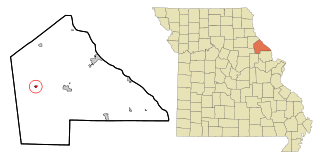
Benton City is a village in Audrain County, Missouri, United States. The population was 104 at the 2010 census.

<span class="mw-page-title-main">Laddonia, Missouri</span> City in Missouri, United States

Laddonia is a city in Audrain County, Missouri, United States. The population was 502 at the 2020 census.

<span class="mw-page-title-main">Martinsburg, Missouri</span> City in Missouri, United States

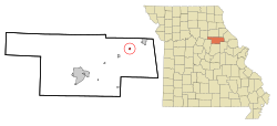
Martinsburg is a city in Audrain County, Missouri, United States. The population was 304 at the 2010 census.

<span class="mw-page-title-main">Rush Hill, Missouri</span> Village in Missouri, United States

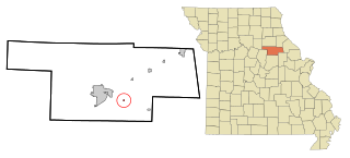
Rush Hill is a village in Audrain County, Missouri, United States. The population was 151 at the 2010 census.

<span class="mw-page-title-main">Vandiver, Missouri</span> Village in Missouri, United States

Vandiver is a village in Audrain County, Missouri, United States. As of the 2010 census, the village population was 77.

<span class="mw-page-title-main">Belton, Missouri</span> City in Missouri, United States

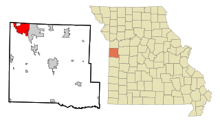
Belton is a city in northwestern Cass County, Missouri, United States. The population was 23,953 at the 2020 census.

<span class="mw-page-title-main">Linneus, Missouri</span> City in Missouri, United States

Linneus is a small city in Linn County, Missouri, United States. The population was 281 at the 2020 census. It is the county seat of Linn County.

<span class="mw-page-title-main">Green Ridge, Missouri</span> City in Missouri, United States

Green Ridge is a city located along Route 127 in Pettis County, Missouri, United States. The population was 476 at the 2010 census.

<span class="mw-page-title-main">Curryville, Missouri</span> City in Missouri, United States

Curryville is a city in western Pike County, Missouri, United States. The population was 225 at the 2010 census.

<span class="mw-page-title-main">Nelson, Missouri</span> City in Missouri, United States

Nelson is a city in Saline County, Missouri, United States. The population was 152 at the 2020 census.

<span class="mw-page-title-main">Country Club Hills, Missouri</span> City in Missouri, United States

Country Club Hills is a city in St. Louis County, Missouri, United States. The population was 1,274 at the 2010 census.

<span class="mw-page-title-main">Hazelwood, Missouri</span> City in Missouri, United States

Hazelwood is a city in St. Louis County, Missouri, within Greater St. Louis. It is a second-ring northern suburb of St. Louis. Based on the 2020 United States census, the city had a total population of 25,485. It is located north of St. Louis-Lambert International Airport and is situated on Interstates 270 and 170, as well as the much-traveled Lindbergh Boulevard and Highway 370.

<span class="mw-page-title-main">Lakeshire, Missouri</span> City in Missouri, United States

Lakeshire is a city in St. Louis County, Missouri, United States. The population was 1,432 at the 2010 census.

<span class="mw-page-title-main">Manchester, Missouri</span> City in Missouri, United States

Manchester is a city in St. Louis County, Missouri, United States. The population was 18,333 at the 2020 census.

<span class="mw-page-title-main">Velda City, Missouri</span> City in Missouri, United States

Velda City is a city in St. Louis County, Missouri, United States. The population was 1,420 at the 2010 census.

<span class="mw-page-title-main">Clarkson Valley, Missouri</span> City in Missouri, United States

Clarkson Valley is a city in St. Louis County, Missouri, United States. The population was 2,609 at the 2020 census.

<span class="mw-page-title-main">Moline Acres, Missouri</span> City in Missouri, United States

Moline Acres is a city in St. Louis County, Missouri, United States. The population was 2,442 at the 2010 census.

<span class="mw-page-title-main">Warson Woods, Missouri</span> City in Missouri, United States

Warson Woods is a city in St. Louis County, Missouri, United States. The population was 1,962 at the 2010 census.

<span class="mw-page-title-main">Centralia, Missouri</span> City in Missouri, United States

Centralia is a city in Boone County in the U.S. state of Missouri. The population was 4,541 at the 2020 census, with an estimated population of 4,244 in 2018. A very small portion of the city lies in Audrain County.

<span class="mw-page-title-main">Vandalia, Missouri</span> City in Missouri, United States

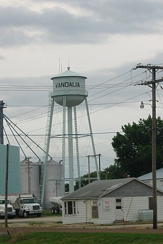
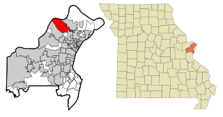
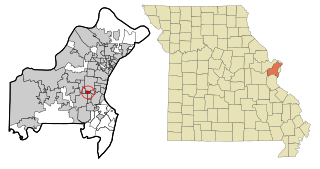
Vandalia is a city in northeastern Audrain and extending into southeastern Ralls Counties in the U.S. state of Missouri. The population was 3,553 at the 2020 census, which includes about 1,000 prisoners incarcerated at the prison located within the city limits.

References

  1. "ArcGIS REST Services Directory". United States Census Bureau. Retrieved August 28, 2022.
  2. 1 2 U.S. Geological Survey Geographic Names Information System: Farber, Missouri
  3. 1 2 "U.S. Census website". United States Census Bureau . Retrieved January 31, 2008.
  4. Eaton, David Wolfe (1916). How Missouri Counties, Towns and Streams Were Named. The State Historical Society of Missouri. pp.  204.
  5. "Audrain County Place Names, 1928-1945 (archived)". The State Historical Society of Missouri. Archived from the original on June 24, 2016. Retrieved August 30, 2016.{{cite web}}: CS1 maint: bot: original URL status unknown (link)
  6. "Post Offices". Jim Forte Postal History. Archived from the original on March 6, 2016. Retrieved August 27, 2016.
  7. "US Gazetteer files 2010". United States Census Bureau. Archived from the original on January 25, 2012. Retrieved July 8, 2012.
  8. "Census of Population and Housing". Census.gov. Retrieved June 4, 2015.
  9. "U.S. Census website". United States Census Bureau . Retrieved July 8, 2012.
  10. "Directory". Mexico-Audrain Library District. Archived from the original on June 2, 2019. Retrieved June 1, 2019.