Dallas is a city in the U.S. state of Texas and the largest city in and seat of Dallas County, with portions extending into Collin, Denton, Kaufman and Rockwall counties. With an estimated 2019 population of 1,343,573, it is the ninth most-populous city in the U.S. and the third-largest in Texas after San Antonio and Houston. Located in North Texas, the city of Dallas is the main core of the largest metropolitan area in the Southern United States and the largest inland metropolitan area in the U.S. that lacks any navigable link to the sea. It is the most populous city in the Dallas–Fort Worth metroplex, the fourth-largest metropolitan area in the country at 7.5 million people.

Deep Ellum is a neighborhood composed largely of arts and entertainment venues near downtown in East Dallas, Texas. The name is based on a corruption of the area's principal thoroughfare, Elm Street. Older alternative uses include Deep Elm and Deep Elem.
The Main Street District of downtown Dallas, Texas runs along Main Street and is bounded by Elm Street one block north, Commerce St. one block south, N. Lamar St. to the west, and US 75/I-45 (I-345) elevated highway to the east. The district is the spine of downtown Dallas, and connects many of the adjoining business and entertainment districts. It does not include Dealey Plaza or the John Fitzgerald Kennedy Memorial which are a few blocks west in the West End Historic District.

The West End Historic District of Dallas, Texas, is a historic district that includes a 67.5-acre (27.3 ha) area in northwest downtown, generally north of Commerce, east of I-35E, west of Lamar and south of Woodall Rodgers Freeway. It is south of Victory Park, west of the Arts, City Center, and Main Street districts, and north of the Government and Reunion districts. A portion of the district is listed on the U.S. National Register of Historic Places as Westend Historic District. A smaller area is also a Dallas Landmark District. The far western part of the district belongs to the Dealey Plaza Historic District, a National Historic Landmark around structures and memorials associated with the Assassination of John F. Kennedy.

The Cedars is a district in south Dallas Texas (USA). It is adjacent to and south of downtown and Interstate 30, east of Austin Street, north of Corinth Street, and west of the 75 & 345 Overpasses just east of South Good Latimer Expy.

The Arts District is a performing and visual arts district in downtown Dallas, Texas.

The Reunion district of downtown Dallas, Texas (USA) is an area in western downtown anchored by the Hyatt Regency Dallas and Reunion Tower. The name "Reunion" originates from the mid-nineteenth century commune, La Reunion.
Bryan Place is a neighborhood in Old East Dallas, Texas (USA). It is east of the Arts District of downtown and the State Thomas neighborhood, north of Deep Ellum, south of Cityplace and west of Munger Place. Its boundaries are generally considered to be US-75 North Central Expressway on the west, Ross Avenue on the (north)west, N. Washington Street on the (north)east, and Live Oak Avenue on the (south)east.

The Government District is an area in south-central downtown Dallas, Texas (USA). It lies south of the Main Street District, southeast of the West End Historic District, north of the Convention Center District, west of the Farmers Market District, and east of the Reunion District.

The Convention Center District is an area in southern downtown Dallas, Texas (USA). It lies south of the Government District, north of the Cedars, west of the Farmers Market District, and east of the Reunion District.Visitdallas is contracted by the City to attract conventions although an audit released in January 2019 cast doubts on its effectiveness.
The City Center District is an area in north-central downtown Dallas, Texas (USA). It lies south of the Arts District, north of the Main Street District, northwest of Deep Ellum, southwest of Bryan Place and east of the West End Historic District. The district contains a large concentration of downtown commercial space which prior to 1950 had been concentrated along Main Street. The district also contains remnants of Theatre Row, the historical entertainment area along Elm Street which contained theatres such as the Majestic Theatre.

North Dallas High School is a public secondary school located in the Oak Lawn area of Dallas, Texas, United States. It enrolls students in grades 9-12 and is a part of the Dallas Independent School District. As of 2017, the principal administrator is Katherine Eska.
The Good-Latimer Expressway is a street in the central part of Dallas, in the northeastern part of the U.S. state of Texas. It begins in south Dallas as an exit off U.S. Highway 175 (US 175) at that highway's western terminus at Interstate 45 (I-45). The street travels in a north-northwest direction through south Dallas, the Cedars, the Farmers Market District of downtown, and finally through Deep Ellum. It becomes Routh Street as it passes out of Deep Ellum underneath I-345. It was part of US 75 until 1987, connecting the two freeway sections of the Central Expressway. From January 28, 1987 to June 25, 1991, when the portion between I-45 and I-345 was given to the city of Dallas, that segment was Spur 559. The expressway was named for former Mayor and Judge John Jay Good and James W. "Weck" Latimer, editor of the Dallas Herald, both citizens from Dallas' pioneer past.
This article is about the culture of Dallas, Texas (USA).
Exposition Park is a neighborhood in south Dallas, Texas (USA). Centered along tree-lined Exposition Avenue, the small enclave stretches from the eastern edge of Deep Ellum to the entrance of Fair Park. The area includes Exposition Plaza, a one acre special use park established in 1984 that features an amphitheater and sculpture areas.
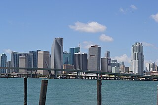
Downtown Miami is an urban city center, based around the Central Business District of Miami, Florida, United States. In addition to the central business district, the area also consists of the Brickell Financial District, Historic District, Government Center, Arts & Entertainment District and Park West. The neighborhood is divided by the Miami River and is bordered by Midtown to the north, Biscayne Bay to the east, Civic Center and Overtown to the west, and Coconut Grove to the south.

James Madison High School, formerly Forest Avenue High School, is a public secondary school in Dallas, Texas (USA). Madison High School enrolls students in grades 9-12 and is a part of the Dallas Independent School District.
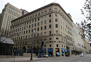
The Titche–Goettinger Building is one of Dallas' original broad-front department stores located along St. Paul Street between Main and Elm Street in downtown Dallas, Texas (USA). The structure currently houses apartments, retail space, and the Universities Center at Dallas. It is listed on the National Register of Historic Places both individually and as a contributing property in the Dallas Downtown Historic District and is a Dallas Landmark as part of the Harwood Street Historic District. It is also located across the street from Main Street Garden Park.
North Dallas is an area of numerous communities and neighborhoods in Dallas, Texas. The phrase "North Dallas" is also sometimes used to include any suburb or exurb north of Dallas proper within the metropolitan area. The majority of North Dallas is located in Dallas County, while a small portion is located in Collin and Denton Counties. North Dallas generally includes areas of Dallas north of Northwest Highway, along with Lake Highlands and areas of Dallas north of IH-635 known as Far North Dallas. The area has strong social and economic ties to the Dallas enclave of Park Cities, and two inner suburbs of Dallas, Richardson and Addison. It is the wealthiest part of Dallas, but has its adjacent, less resourced areas as well.

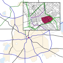
Downtown Dallas is the central business district (CBD) of Dallas, Texas, USA, located in the geographic center of the city. The area termed "Downtown" has traditionally been defined as bounded by the downtown freeway loop, bounded on the east by I-345 (although known and signed as the northern terminus of I-45 and the southern terminus of US 75, on the west by I-35E, on the south by I-30, and on the north by Spur 366.