
A severe thunderstorm warning is a type of public warning for severe weather that is issued by weather forecasting agencies worldwide when one or more severe thunderstorms have been detected by Doppler weather radar, observed by weather spotters, or reported by an emergency management agency, law enforcement, or the general public. Unlike a watch, a warning is issued to areas in the direct path of active severe thunderstorms, that are expecting a direct impact typically within an hour. Severe thunderstorms can cause property damage and injury due to large hail, high winds, and flooding due to torrential rainfall. The exact criteria to issue a warning varies from country to country.

Pineapple Express is a specific recurring atmospheric river both in the waters immediately northeast of the Hawaiian Islands and extending northeast to any location along the Pacific coast of North America. It is a non-technical term and a meteorological phenomenon. It is characterized by a strong and persistent large-scale flow of warm moist air, and the associated heavy precipitation. A Pineapple Express is an example of an atmospheric river, which is a more general term for such relatively narrow corridors of enhanced water vapor transport at mid-latitudes around the world.

Hurricane Diana was a deadly tropical cyclone which made landfall in Mexico in August 1990. The fourth named storm and second hurricane of the season, Diana developed from a tropical wave in the southwestern Caribbean on August 4. Forming as a tropical depression, the system brushed Honduras before intensifying into a tropical storm the following day. Continuing to gradually strengthen, Diana made its first landfall in Mexico's Yucatán Peninsula as a strong tropical storm late on August 5. The cyclone weakened slightly due to land interaction, before emerging into the Bay of Campeche on August 6. Once over water, warm sea surface temperatures allowed Diana to quickly become a hurricane and later peak as a Category 2 on the Saffir–Simpson hurricane scale on August 7. Shortly thereafter, the storm made landfall near Tampico, Tamaulipas, with winds of 100 mph (160 km/h). Rapid weakening ensued once the storm moved over the high terrain of Mexico, with Diana diminishing to a tropical depression roughly 24 hours after moving onshore. The cyclone later emerged into the Gulf of California on August 9 shortly before dissipating. The remnant disturbance was monitored until losing its identity over Arizona on August 14.

Hurricane Kathleen was a Category 1 Pacific hurricane that had a destructive impact in California. On September 7, 1976, a tropical depression formed; two days later it accelerated north towards the Baja California Peninsula. Kathleen brushed the Pacific coast of the peninsula as a hurricane on September 9 and made landfall as a fast-moving tropical storm the next day. With its circulation intact and still a tropical storm, Kathleen headed north into the United States and affected California and Arizona. Kathleen finally dissipated late on September 11.

Tropical Storm Doria was the costliest tropical cyclone in the 1971 Atlantic hurricane season. The fifth tropical storm of the season, Doria developed from a tropical wave on August 20 to the east of the Lesser Antilles, and after five days without development it attained tropical storm status to the east of Florida. Doria turned to the north, and reached peak winds of 65 mph (105 km/h) as it was making landfall near Morehead City, North Carolina. It turned to the northeast, and moved through the Mid-Atlantic and New England as a tropical storm before becoming an extratropical storm over Maine on August 29.

The climate of California varies widely from hot desert to alpine tundra, depending on latitude, elevation, and proximity to the Pacific Coast. California's coastal regions, the Sierra Nevada foothills, and much of the Central Valley have a Mediterranean climate, with warmer, drier weather in summer and cooler, wetter weather in winter. The influence of the ocean generally moderates temperature extremes, creating warmer winters and substantially cooler summers in coastal areas.

Hurricane Isis was the only hurricane to make landfall during the 1998 Pacific hurricane season. The ninth tropical storm and sixth hurricane of the season, Isis developed on September 1 from an interaction between a tropical wave and a large surface circulation to the southwest of Mexico. It moved northward, striking the extreme southeastern portion of the Baja California peninsula before attaining hurricane status in the Gulf of California. Isis made landfall at Topolobampo in the Mexican state of Sinaloa on September 3, and quickly lost its low-level circulation. The remnants persisted for several days before dissipating over the U.S. state of Idaho on September 8.

All types of floods can occur in California, though 90 percent of them are caused by river flooding in lowland areas. Such flooding generally occurs as a result of excessive rainfall, excessive snowmelt, excessive runoff, levee failure, poor planning or built infrastructure, or a combination of these factors. Below is a list of flood events that were of significant impact to California.

The January 2008 North American storm complex was a powerful Pacific extratropical cyclone that affected a large portion of North America, primarily stretching from western British Columbia to near the Tijuana, Mexico area, starting on January 3, 2008. The system was responsible for flooding rains across many areas in California along with very strong winds locally exceeding hurricane force strength as well as heavy mountain snows across the Cascade and Sierra Nevada mountain chains as well as those in Idaho, Utah and Colorado. The storms were responsible for the death of at least 12 people across three states, and extensive damage to utility services as well, as damage to some other structures. The storm was also responsible for most of the January 2008 tornado outbreak from January 7–8.

Tropical Storm Edouard brought coastal and minor inland flooding to Louisiana and Texas in August 2008. The fifth tropical cyclone and fifth named storm of the hurricane season, Edouard developed from a trough in the northern Gulf of Mexico on August 3. After developing into a tropical depression, it gradually strengthened and was upgraded to Tropical Storm Edouard on August 4. However, northerly wind shear initially halted any further significant intensification and also caused the storm to struggle to maintain deep convection over the center. Edouard eventually intensified further and peaked as a strong tropical storm with winds of 65 mph (100 km/h) on August 5. Shortly thereafter, the storm made landfall near Gilchrist, Texas later that day. Edouard quickly weakened and was downgraded to tropical depression by early on August 6, six hours before degenerated into a remnant low pressure area.

Hurricane Ramon was a very intense Pacific hurricane whose remnants generated heavy rains in Southern California. The 19th named storm and final hurricane of the above-average 1987 Pacific hurricane season, Ramon originated from a tropical disturbance that formed in early October. On October 5, a tropical storm had developed several hundred miles southwest of Manzanillo, bypassing the tropical depression stage. Tropical Storm Ramon turned to the west-northwest after initially moving west. It intensified into a hurricane on October 7. Two days later, Hurricane Ramon peaked in intensity with winds of 140 mph (220 km/h). After peaking, Ramon turned to the northwest and rapidly weakened over cooler waters. It weakened into a tropical storm on October 11 and a depression on October 12. Ramon dissipated shortly thereafter. While at sea, Ramon brought light rainfall to the Baja California Peninsula. The remnants of Hurricane Ramon produced heavy rainfall that caused flooding in California, indirectly contributing to five traffic-related fatalities. Rainfall was reported as far inland as Utah.

Tropical Storm Andrea brought flooding to Cuba, the Yucatan Peninsula, and portions of the East Coast of the United States in June 2013. The first tropical cyclone and named storm of the annual hurricane season, Andrea originated from an area of low pressure in the eastern Gulf of Mexico on June 5. Despite strong wind shear and an abundance of dry air, the storm strengthened while initially heading north-northeastward. Later on June 5, it re-curved northeastward and approached the Big Bend region of Florida. Andrea intensified and peaked as a strong tropical storm with winds at 65 mph (105 km/h) on June 6. A few hours later, the storm weakened slightly and made landfall near Steinhatchee, Florida later that day. It began losing tropical characteristics while tracking across Florida and Georgia. Andrea transitioned into an extratropical cyclone over South Carolina on June 7, though the remnants continued to move along the East Coast of the United States, until being absorbed by another extratropical system offshore Maine on June 10.

The January 2010 North American winter storms were a group of seven powerful winter storms that affected Canada and the Contiguous United States, particularly California. The storms developed from the combination of a strong El Niño episode, a powerful jet stream, and an atmospheric river that opened from the West Pacific Ocean into the Western Seaboard. The storms shattered multiple records across the Western United States, with the sixth storm breaking records for the lowest recorded air pressure in multiple parts of California, which was also the most powerful winter storm to strike the Southwestern United States in 140 years. The fourth, fifth, and sixth storms spawned several tornadoes across California, with at least 6 tornadoes confirmed in California ; the storms also spawned multiple waterspouts off the coast of California. The storms dumped record amounts of rain and snow in the Western United States, and also brought hurricane-force winds to the U.S. West Coast, causing flooding and wind damage, as well as triggering blackouts across California that cut the power to more than 1.3 million customers. The storms killed at least 10 people, and caused more than $66.879 million in damages.

The March 2014 North American winter storm, also unofficially referred to as Winter Storm Titan, was an extremely powerful winter storm that affected much of the United States and portions of Canada. It was one of the most severe winter storms of the 2013–14 North American winter storm season, storm affecting most of the Western Seaboard, and various parts of the Eastern United States, bringing damaging winds, flash floods, and blizzard and icy conditions.

The December 2014 North American storm complex was a powerful winter storm that impacted the West Coast of the United States, beginning on the night of December 10, 2014, resulting in snow, wind, and flood watches. Fueled by the Pineapple Express, an atmospheric river originating in the tropical waters of the Pacific Ocean adjacent to the Hawaiian Islands, the storm was the strongest to affect California since January 2010. The system was also the single most intense storm to impact the West Coast, in terms of minimum low pressure, since a powerful winter storm in January 2008. The National Weather Service classified the storm as a significant threat, and issued 15 warnings and advisories, including a Blizzard Warning for the Northern Sierra Nevada.
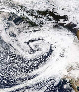
An extremely powerful extratropical bomb cyclone began in late October 2021 in the Northeast Pacific and struck the Western United States and Western Canada. The storm was the third and the most powerful cyclone in a series of powerful storms that struck the region within a week. The cyclone tapped into a large atmospheric river and underwent explosive intensification, becoming a bomb cyclone on October 24. The bomb cyclone had a minimum central pressure of 942 millibars (27.8 inHg) at its peak, making it the most powerful cyclone recorded in the Northeast Pacific. The system had severe impacts across Western North America, before dissipating on October 26. The storm shattered multiple pressure records across parts of the Pacific Northwest. Additionally, the bomb cyclone was the most powerful storm on record to strike the region, in terms of minimum central pressure. The bomb cyclone brought powerful gale-force winds and flooding to portions of Western North America. At its height, the storm cut the power to over 370,500 customers across the Western U.S. and British Columbia. The storm killed at least two people; damage from the storm was estimated at several hundred million dollars. The bomb cyclone was compared to the Columbus Day Storm of 1962, in terms of ferocity.

Periods of heavy rainfall caused by multiple atmospheric rivers in California between December 31, 2022, and March 25, 2023, resulted in floods that affected parts of Southern California, the California Central Coast, Northern California and Nevada. The flooding resulted in property damage and at least 22 fatalities. At least 200,000 homes and businesses lost power during the December-January storms and 6,000 individuals were ordered to evacuate.

Hurricane Hilary was a large and powerful Pacific hurricane in August 2023 that brought torrential rainfall and gusty winds to the Pacific Coast of Mexico, the Baja California Peninsula, and the Southwestern United States, resulting in widespread flooding and mudslides. The cyclone was the eighth named storm, sixth hurricane, and fourth major hurricane of the 2023 Pacific hurricane season. Hilary originated from a tropical wave south of Mexico on August 16, and strengthened into a hurricane a day later while paralleling the southwest coast of Mexico. The hurricane underwent rapid intensification, reaching maximum sustained winds of 140 mph (220 km/h) and a central pressure of 940 mbar (27.76 inHg) on August 18, making it a Category 4 on the Saffir-Simpson scale. After environmental conditions became unfavorable, Hilary weakened as it approached land, making landfall as a tropical storm in San Quintín along the western Baja California peninsula, becoming post-tropical before being absorbed into a new system shortly after.


