Pineapple Express

Last updated

November 2006 satellite image showing clouds from north of Hawaii to Washington, a Pineapple Express configuration IR16.png
November 2006 satellite image showing clouds from north of Hawaii to Washington, a Pineapple Express configuration

Pineapple Express is a specific recurring atmospheric river both in the waters immediately northeast of the Hawaiian Islands and extending northeast to any location along the Pacific coast of North America. It is a non-technical term and a meteorological phenomenon. It is characterized by a strong and persistent large-scale flow of warm moist air, and the associated heavy precipitation. A Pineapple Express is an example of an atmospheric river, which is a more general term for such relatively narrow corridors of enhanced water vapor transport at mid-latitudes around the world.

Contents

Causes and effects

How the Madden-Julian oscillation can induce a Pineapple Express Mjo north america rain.png
How the Madden–Julian oscillation can induce a Pineapple Express
NASA Geostationary Operational Environmental Satellite called GOES-11, image of the "Pineapple Express" captured at 1800 UTC (1 p.m. EST) on 19 December 2010. Pineapple Express to California from NASA GOES.jpg
NASA Geostationary Operational Environmental Satellite called GOES-11, image of the "Pineapple Express" captured at 1800 UTC (1 p.m. EST) on 19 December 2010.

A Pineapple Express is driven by a strong, southern branch of the polar jet stream and is marked by the presence of a surface frontal boundary which is typically either slow or stationary, with waves of low pressure traveling along its length. Each of these low-pressure systems brings enhanced rainfall.

The conditions are often created by the Madden–Julian oscillation, an equatorial rainfall pattern which feeds its moisture into this pattern. They are also present during an El Niño episode.

The combination of moisture-laden air, atmospheric dynamics, and orographic enhancement resulting from the passage of this air over the mountain ranges of the western coast of North America causes some of the most torrential rains to occur in the region. Pineapple Express systems typically generate heavy snowfall in the mountains and Interior Plateau, which often melts rapidly because of the warming effect of the system. After being drained of their moisture, the tropical air masses reach the inland prairies as a Chinook wind or simply "a Chinook", a term which is also synonymous in the Pacific Northwest with the Pineapple Express.[ citation needed ]

Extreme cases

Many Pineapple Express events follow or occur simultaneously with major arctic troughs in the northwestern United States, often leading to major snow-melt flooding with warm, tropical rains falling on frozen, snow laden ground. [1] Examples of this are the Christmas flood of 1964, Willamette Valley flood of 1996, New Year's Day Flood of 1997, January 2006 Flood in Northern California and Nevada, Great Coastal Gale of 2007, January 2008 Flood in Nevada, January 2009 Flood in Washington, the January 2012 Flood in Oregon, the 2019 Valentine's Day Flood in Southern California, [2] and the February 2020 floods in Oregon and Washington. [3]

West coast, 1862

Early in 1862, extreme storms riding the Pineapple Express [4] [5] battered the west coast for 45 days. In addition to a sudden snow melt, some places received an estimated 8.5 feet (2,600 mm) of rain, [5] leading to the worst flooding in recorded history of California, Oregon, and Nevada, known as the Great Flood of 1862. Both the Sacramento and San Joaquin valleys flooded, and there was extensive flooding and mudslides throughout the region. [6]

Northern California, 1952

The San Francisco Bay Area is another locale along the Pacific Coast which is occasionally affected by a Pineapple Express. When it visits, the heavy, persistent rainfall typically causes flooding of local streams as well as urban flooding. In the decades before about 1980, the local term for a Pineapple Express was "Hawaiian Storm". [7] During the second week of January 1952, a series of "Hawaiian" storms swept into Northern California, causing widespread flooding around the Bay Area.

The same storms brought a blizzard of heavy, wet snow to the Sierra Nevada Mountains, notoriously stranding the train City of San Francisco on 13 January.

Northern California, 1955

The greatest flooding in Northern California since the 1800s occurred in 1955 as a result of a series of Hawaiian storms, with the greatest damage in the Sacramento Valley around Yuba City. [8]

Southern California, 2005

Unusually high precipitation caused an ephemeral lake to occur in the Badwater Basin of Death Valley National Park, 2005. LakeBadwater.JPG
Unusually high precipitation caused an ephemeral lake to occur in the Badwater Basin of Death Valley National Park, 2005.

A Pineapple Express related storm battered Southern California from January 7–11, 2005. This storm was the largest to hit Southern California since the storms that hit during the 1997–98 El Niño event. [9] The storm caused mud slides and flooding, with one desert location just north of Morongo Valley receiving about 9 inches (230 mm) of rain, and some locations on south and southwest-facing mountain slopes receiving spectacular totals: San Marcos Pass, in Santa Barbara County, received 24.57 inches (624 mm), and Opids Camp (AKA Camp Hi-Hill) in the San Gabriel Mountains of Los Angeles County was deluged with 31.61 inches (803 mm) of rain in the five-day period. [10] In some areas the storm was followed by over a month of near-continuous rain.[ citation needed ]

Alaska, 2006

The unusually intense rainstorms that hit south-central Alaska in October 2006 were called "Pineapple Express" rains locally. [11]

Pacific Northwest, 2006

November 2006 flood, Granite Falls on the Stillaguamish River, Washington Granite Falls 26428.JPG
November 2006 flood, Granite Falls on the Stillaguamish River, Washington

The Puget Sound region from Olympia, Washington to Vancouver, British Columbia received several inches of rain per day in November 2006 from a series of successive Pineapple Express related storms that caused massive flooding in all major regional rivers and mudslides which closed the mountain passes. These storms included heavy winds which are not usually associated with the phenomenon. Regional dams opened their spillways to 100% as they had reached capacity because of rain and snowmelt. Officials referred to the storm system as "the worst in a decade" on 8 November 2006. Portions of Oregon were also affected, including over 14 inches (360 mm) in one day at Lees Camp in the Coast Range, while the normally arid and sheltered Interior of British Columbia received heavy, coastal-magnitude rains.[ citation needed ]

Southern California, December 2010

In December 2010, a Pineapple Express system ravaged California from 15–22 December, bringing with it as much as 2 feet (610 mm) of rain to the San Gabriel Mountains, and over 13 feet (4.0 m) of snow in the Sierra Nevada. Although the entire state was affected, the Southern California counties of San Bernardino, Orange, Riverside, San Diego, and Los Angeles bore the brunt of the system of storms, as coastal and hillside areas were impacted by mudslides and major flooding. [12]

California, December 2014

In December 2014, a powerful winter storm enhanced by a Pineapple Express feature struck California, resulting in snow, wind, and flood watches. [13] A blizzard warning was issued by the National Weather Service for the Northern Sierra Nevada for the first time in California since October 2009 and January 2008. [14] The storm caused power outages for more than 50,000 people. [15] It was thought to be the most powerful storm to impact California since the January 2010 California winter storms. [16] [17] A rare tornado touched down in Los Angeles on 12 December. [18]

West Coast, 2017

Historically strong storms associated with the Pineapple Express brought flooding and mudslides to California, particularly the San Francisco Bay Area, destroying homes and closing numerous roads, including State Route 17, State Route 35, State Route 37, Interstate 80, State Route 12, State Route 1, State Route 84, State Route 9 and State Route 152. [19] [20]

The storm brought major snow to the Sierra Nevada and San Gabriel Mountains. A state record was recorded with places on the Sierra reaching up to 800 inches (20 m) of snow. The storm also brought not only significant flooding to the Los Angeles area and most of southern California (killing about 3 people), but also significant severe weather in that area.

California, January 2021

A powerful winter storm channeled a Pineapple Express into California from 26–29 January. One person was injured in one of the mudslides in Northern California, and many structures suffered damage. [21] The storm killed at least two people in California. [22] [23] A significant length of California State Route 1 along the Big Sur collapsed into the ocean after massive amounts of rain were dumped, causing a debris flow onto the highway, which in turn triggered the collapse. [24] In Southern California, the storm triggered widespread flooding and debris flows, forcing the evacuations of thousands of people and also causing widespread property damage. [25] Salinas received 4 in (100 mm) of rainfall for the entire event causing mudflows that forced 7,000 people to evacuate. Across the State of California, the storm knocked out power to an estimated 575,000 people at one point, according to power outage tracking maps and PG&E. [26] [25] In the mountainous parts of the state, the winter storm dropped tremendous amounts of heavy snow, with Mammoth Mountain Ski Area receiving 94 in (240 cm) within 72 hours, and a total of 107 in (270 cm) of snowfall for the entire event. [27] Blizzard conditions were also recorded on parts of the Sierra Nevada. [26] Very high wind gusts were also observed, with gusts over 100 mph (160 km/h) observed at Alpine Meadows, peaking at 126 mph (203 km/h). [28]

Pacific Northwest, 2021

Heavy rains attributed to a Pineapple Express event heavily impacted the Puget Sound region from Bellingham, Washington into the British Columbia Interior and the Lower Mainland from 14–15 November. [29] At the peak of the rainstorm on 15 November, Bellingham received 2.78 inches (71 mm) of rain while Hope, B.C. measured rainfall of 277.5 millimetres (10.93 in) from 14–15 November. [30] The resulting floods and ensuing mass wasting events forced the closure of all major Canadian road connections to Vancouver, British Columbia including Highway 1, the Coquihalla, and the Sea to Sky Highway. [31]

California, 2022–2023

Heavy rains attributed to a Pineapple Express caused widespread flooding in the Bay Area. [32]

California, February 2024

A Pineapple Express storm hit the state from 1 to 2 February 2024, before moving over the United States and settling over the I-25 corridor in Colorado, where heavy snow fell. Another one hit 3 February and last until 5 February, with the National Weather Service calling it "potentially life-threatening." Other news sources estimated that Los Angeles received six-months' worth of rain in the 48-hour period, while the Sierra Nevada mountains got 1 to 3 ft (30 to 91 cm) of snow, with over 4 feet (120 cm) of snow expected in higher elevations, such as Mammoth Lakes, CA. Parts of the San Bernardino Mountains' foothills received 10 to 12 in (250 to 300 mm) of rain. [33]

See also

Related Research Articles

<span class="mw-page-title-main">Hurricane Kathleen</span> Category 1 Pacific hurricane in 1976

Hurricane Kathleen was a Category 1 Pacific hurricane that had a destructive impact in California. On September 7, 1976, a tropical depression formed; two days later it accelerated north towards the Baja California Peninsula. Kathleen brushed the Pacific coast of the peninsula as a hurricane on September 9 and made landfall as a fast-moving tropical storm the next day. With its circulation intact and still a tropical storm, Kathleen headed north into the United States and affected California and Arizona. Kathleen finally dissipated late on September 11.

Floods in the United States are generally caused by excessive rainfall, excessive snowmelt, and dam failure. Below is a list of flood events that were of significant impact to the country during the 20th century, from 1900 through 1999, inclusive.

<span class="mw-page-title-main">Climate of California</span> Overview of the climate of the U.S. state of California

The climate of California varies widely from hot desert to alpine tundra, depending on latitude, elevation, and proximity to the Pacific Coast. California's coastal regions, the Sierra Nevada foothills, and much of the Central Valley have a Mediterranean climate, with warmer, drier weather in summer and cooler, wetter weather in winter. The influence of the ocean generally moderates temperature extremes, creating warmer winters and substantially cooler summers in coastal areas.

<span class="mw-page-title-main">Floods in California</span> History of floods in California

All types of floods can occur in California, though 90 percent of them are caused by river flooding in lowland areas. Such flooding generally occurs as a result of excessive rainfall, excessive snowmelt, excessive runoff, levee failure, poor planning or built infrastructure, or a combination of these factors. Below is a list of flood events that were of significant impact to California.

<span class="mw-page-title-main">Great Coastal Gale of 2007</span> Storm in the United States and Canada

The Great Coastal Storm of 2007 was a series of three powerful Pacific storms that affected the U.S. states of Oregon and Washington and the Canadian province of British Columbia between December 1, 2007 and December 4, 2007.

<span class="mw-page-title-main">January 2008 North American storm complex</span>

The January 2008 North American storm complex was a powerful Pacific extratropical cyclone that affected a large portion of North America, primarily stretching from western British Columbia to near the Tijuana, Mexico area, starting on January 3, 2008. The system was responsible for flooding rains across many areas in California along with very strong winds locally exceeding hurricane force strength as well as heavy mountain snows across the Cascade and Sierra Nevada mountain chains as well as those in Idaho, Utah and Colorado. The storms were responsible for the death of at least 12 people across three states, and extensive damage to utility services as well, as damage to some other structures. The storm was also responsible for most of the January 2008 tornado outbreak from January 7–8.

<span class="mw-page-title-main">Hurricane Norman (1978)</span> Category 4 Pacific hurricane in 1978

Hurricane Norman was a rare tropical cyclone that impacted California in early September 1978. The fourteenth named storm, eleventh hurricane, and sixth major hurricane of the 1978 Pacific season, Norman originated from an tropical wave that spawned an area of disturbed weather south of Acapulco. The system coalesced into a tropical depression on August 30 and thrived amid favorable environmental conditions, becoming a powerful Category 4 hurricane with winds of 140 mph (230 km/h) at its peak intensity. The system curved northward, passing into cooler waters that brought an end to its status as a tropical cyclone on September 6. However, its remnants combined with an trough and front over California, contributing to locally heavy rainfall that caused dozens of traffic accidents and sporadic power outages. In higher elevations, the system produced accumulating snow which stranded and killed many hikers throughout Sierra Nevada. Most heavily affected was California's raisin crop, which suffered a record-breaking 95 percent loss. Overall, Norman killed eight people and caused over $300 million in damage.

<span class="mw-page-title-main">October 2009 North American storm complex</span>

The October 2009 North American storm complex was a powerful extratropical cyclone that was associated with the remnants of Typhoon Melor, which brought extreme amounts of rainfall to California. The system started out as a weak area of low pressure, that formed in the northern Gulf of Alaska on October 7. Late on October 11, the system quickly absorbed Melor's remnant moisture, which resulted in the system strengthening significantly offshore, before moving southeastward to impact the West Coast of the United States, beginning very early on October 13. Around the same time, an atmospheric river opened up, channeling large amounts of moisture into the storm, resulting in heavy rainfall across California and other parts of the Western United States. The storm caused at least $8.861 million in damages across the West Coast of the United States.

<span class="mw-page-title-main">Weather of 2008</span>

Global storm activity of 2008 profiles the major worldwide storms, including blizzards, ice storms, and other winter events, from January 1, 2008 to December 31, 2008. A winter storm is an event in which the dominant varieties of precipitation are forms that only occur at cold temperatures, such as snow or sleet, or a rainstorm where ground temperatures are cold enough to allow ice to form. It may be marked by strong wind, thunder and lightning, heavy precipitation, such as ice, or wind transporting some substance through the atmosphere. Major dust storms, Hurricanes, cyclones, tornados, gales, flooding and rainstorms are also caused by such phenomena to a lesser or greater existent.

Global weather activity of 2007 profiles the major worldwide weather events, including blizzards, ice storms, tornadoes, tropical cyclones, and other weather events, from January 1, 2007, to December 31, 2007. Winter storms are events in which the dominant varieties of precipitation are formed during cold temperatures; they include snow or sleet, or a rainstorm where ground temperatures are cold enough to allow ice, including freezing rain, to form. Thehy may be marked by strong wind, thunder, lightning thunderstorms, heavy precipitation, including ice storm, wind transporting some substance through the atmosphere, including dust storms, snowstorms, and hail storms. Other major non winter events such as large dust storms, hurricanes, cyclones, tornados, gales, flooding, and rainstorms are also caused by such phenomena.

<span class="mw-page-title-main">Great Flood of 1862</span> Flood in California, Oregon, and Nevada

The Great Flood of 1862 was the largest flood in the recorded history of California, Oregon, and Nevada, inundating the western United States and portions of British Columbia and Mexico. It was preceded by weeks of continuous rains and snows that began in Oregon in November 1861 and continued into January 1862. This was followed by a record amount of rain from January 9–12, and contributed to a flood that extended from the Columbia River southward in western Oregon, and through California to San Diego, and extended as far inland as (now) Idaho in the Washington Territory, (now) Nevada and Utah in the Utah Territory, and (now) Arizona in the western New Mexico Territory. The event dumped an equivalent of 10 feet (3.0 m) of water in California, in the form of rain and snow, over a period of 43 days. Immense snowfalls in the mountains of far western North America caused more flooding in Idaho, Arizona, New Mexico, as well as in Baja California and Sonora, Mexico the following spring and summer, as the snow melted.

<span class="mw-page-title-main">January 2010 North American winter storms</span>

The January 2010 North American winter storms were a group of seven powerful winter storms that affected Canada and the Contiguous United States, particularly California. The storms developed from the combination of a strong El Niño episode, a powerful jet stream, and an atmospheric river that opened from the West Pacific Ocean into the Western Seaboard. The storms shattered multiple records across the Western United States, with the sixth storm breaking records for the lowest recorded air pressure in multiple parts of California, which was also the most powerful winter storm to strike the Southwestern United States in 140 years. The fourth, fifth, and sixth storms spawned several tornadoes across California, with at least 6 tornadoes confirmed in California ; the storms also spawned multiple waterspouts off the coast of California. The storms dumped record amounts of rain and snow in the Western United States, and also brought hurricane-force winds to the U.S. West Coast, causing flooding and wind damage, as well as triggering blackouts across California that cut the power to more than 1.3 million customers. The storms killed at least 10 people, and caused more than $66.879 million in damages.

The January 2018 American West floods occurred due to heavy precipitation in the Western United States. While wildfires in Southern California exacerbated the rain's effects there, other states, like Nevada, also experienced flooding.

<span class="mw-page-title-main">January 31 – February 3, 2021 nor'easter</span>

The January 31 – February 3, 2021 nor'easter, also known as the 2021 Groundhog Day nor'easter, was a powerful, severe, and erratic nor'easter that impacted much of the Northeastern United States and Eastern Canada from February 1–3 with heavy snowfall, blizzard conditions, strong gusty winds, storm surge, and coastal flooding. The storm first developed as an extratropical cyclone off the West Coast of the United States on January 25, with the storm sending a powerful atmospheric river into West Coast states such as California, where very heavy rainfall, snowfall, and strong wind gusts were recorded, causing several hundred thousand power outages and numerous mudslides. The system moved ashore several days later, moving into the Midwest and dropping several inches of snow across the region. On February 1, the system developed into a nor'easter off the coast of the Northeastern U.S., bringing prolific amounts of snowfall to the region. Large metropolitan areas such as Boston and New York City saw as much as 18–24 inches (46–61 cm) of snow accumulations from January 31 to February 2, making it the worst snowstorm to affect the megalopolis since the January 2016 blizzard. It was given the unofficial name Winter Storm Orlena by The Weather Channel.

<span class="mw-page-title-main">Hurricane Olivia (1982)</span> Category 4 Pacific hurricane in 1982

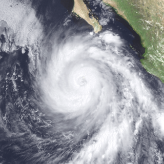
Hurricane Olivia was a powerful and destructive Category 4 hurricane, that brought damaging floods to California and Utah during September 1982. Olivia was the twenty-fourth tropical cyclone, eighteenth named storm, ninth hurricane, and fourth major hurricane of the active 1982 Pacific hurricane season. The storm was first noted as a tropical depression from a ship report off the southern coast of Mexico. Olivia then steadily intensified before becoming a Category 4 hurricane, and reaching its peak intensity with 1-minute sustained winds of around 145 mph (230 km/h), at 18:00 UTC on September 21. The hurricane then rapidly weakened as it passed west of mainland Mexico, before being last noted to the west of California on September 25, as a surface trough.

<span class="mw-page-title-main">October 2021 Northeast Pacific bomb cyclone</span> North American bomb cyclone in 2021

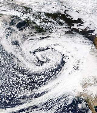
An extremely powerful extratropical bomb cyclone began in late October 2021 in the Northeast Pacific and struck the Western United States and Western Canada. The storm was the third and the most powerful cyclone in a series of powerful storms that struck the region within a week. The cyclone tapped into a large atmospheric river and underwent explosive intensification, becoming a bomb cyclone on October 24. The bomb cyclone had a minimum central pressure of 942 millibars (27.8 inHg) at its peak, making it the most powerful cyclone recorded in the Northeast Pacific. The system had severe impacts across Western North America, before dissipating on October 26. The storm shattered multiple pressure records across parts of the Pacific Northwest. Additionally, the bomb cyclone was the most powerful storm on record to strike the region, in terms of minimum central pressure. The bomb cyclone brought powerful gale-force winds and flooding to portions of Western North America. At its height, the storm cut the power to over 370,500 customers across the Western U.S. and British Columbia. The storm killed at least two people; damage from the storm was estimated at several hundred million dollars. The bomb cyclone was compared to the Columbus Day Storm of 1962, in terms of ferocity.

<span class="mw-page-title-main">Hurricane Kay (2022)</span> Category 2 Pacific hurricane in 2022

Hurricane Kay was a Category 2 hurricane that made landfall along the Pacific coast of the Baja California peninsula as a tropical storm. The twelfth named storm and eighth hurricane of the 2022 Pacific hurricane season, Kay originated from an area of disturbed weather that formed south of southern Mexico. Overall, damage from Kay totaled $10.62 million and it was responsible for five fatalities. Rain from the storm proved beneficial for firefighters battling the Fairview Fire in Southern California.

<span class="mw-page-title-main">2022–2023 California floods</span> Regional natural disaster event

Periods of heavy rainfall caused by multiple atmospheric rivers in California between December 31, 2022, and March 25, 2023, resulted in floods that affected parts of Southern California, the California Central Coast, Northern California and Nevada. The flooding resulted in property damage and at least 22 fatalities. At least 200,000 homes and businesses lost power during the December-January storms and 6,000 individuals were ordered to evacuate.

<span class="mw-page-title-main">February 2024 California atmospheric rivers</span> Weather event

In early February 2024, two atmospheric rivers brought extensive flooding, intense winds, and power outages to portions of California. The storms caused record-breaking rainfall totals to be observed in multiple areas, as well as the declaration of states of emergency in multiple counties in Southern California. Wind gusts of hurricane force were observed in San Francisco, along with wind gusts reaching over 100 miles per hour (160 km/h) in the Sierra Nevada mountains. Widespread landslides occurred as a result of the storms, as well as multiple rivers overflowing due to the excessive rainfall. Meteorologist Dr. Reed Timmer stated that "Biblical flooding" was possible throughout California during the atmospheric river.

References

  1. "State of Idaho Hazard Mitigation Plan" (PDF). United States Army Corps of Engineers National Flood Risk Management Plan. November 2007. Archived from the original (PDF) on 10 December 2014. Retrieved 19 March 2012.
  2. "Torrential Rain Causing Flooding All Over Southern California". 14 February 2019. Retrieved 12 December 2019.
  3. "2020 February Flooding Spotlight". ArcGIS Story Maps. 3 April 2020. Retrieved 31 December 2020.
  4. Overview of the Arkstorm Scenario (PDF). USGS. 2010. p. 2. Beginning in early December 1861 and continuing into early 1862, an extreme series of storms lasting 45 days struck California.
  5. 1 2 Masters, Jeff. "The ARkStorm: California's coming great deluge". Weather Underground. Retrieved 24 April 2014.
  6. Newbold, John D. (Winter 1991). "The Great California Flood of 1861-1862" (PDF). San Joaquin Historian. 5 (4). San Joaquin Historical Society & Museum. Archived from the original (PDF) on 3 March 2016. Retrieved 24 April 2014.
  7. Gilliam, Harold (2002) [1962]. Weather of the San Francisco Bay Region (rev. ed.). Berkeley, CA: University of California Press.
  8. "Floods of December 1955-January 1956 in far-western states" (PDF). Geological Survey Circular. United States Department of the Interior. 1956.
  9. "Jet stream unleashed the rains". Orange County Register. Archived from the original on 16 February 2008. Retrieved 21 October 2007 via OCRegister.com.
  10. "When it rains in L.A., it pours at Opids Camp". Los Angeles Times . 25 February 2005. Retrieved 19 March 2012.
  11. "2007 WASHTO Subcommittee on Maintenance – Alaska Scanning Tour – Proceedings" (PDF). U.S. Department of Transportation. 14–18 August 2007. pp. 9–10. Retrieved 2 June 2011. On 10 October 2006 an unusual weather formation forced some upper level moisture out of the Pacific Ocean into Alaska. This "Pineapple Express" produced over 5 inches of rain over a twenty-four hour period.
  12. "Pineapple Express blamed for S. Cal storms". UPI.com. 22 December 2010. Retrieved 19 March 2012.
  13. Fritz, Angela (10 December 2014). "Strongest West Coast storm in five years promises flooding rain, heavy snow, and extreme wind". The Washington Post . Retrieved 10 December 2014.
  14. Rocha, Veronica (10 December 2014). "California braces for major winter storm". Los Angeles Times . Retrieved 11 December 2014.
  15. "Thousands lose power in San Francisco". Time . Retrieved 12 December 2014.
  16. Rice, Doyle (10 December 2014). "California braces for fiercest storm in 5 years". USA Today. Retrieved 11 December 2014.
  17. "California: State braces for powerful wind and floods". The New York Times . 10 December 2014. Retrieved 11 December 2014.
  18. "Los Angeles tornado violently wakes up city". NJ Today. Retrieved 13 December 2014.
  19. "At least 8 Bay Area highways closed due to flooding". ABC‑7 San Francisco. 7 February 2017. Retrieved 22 February 2017.
  20. "Bay Area storm brings heavy rain, strong winds, mayhem". San Jose Mercury News. 9 February 2017. Retrieved 22 February 2017.
  21. Moon, Sarah (29 January 2021). "One woman injured, 25 structures damaged as powerful winter storm unleashes mudslides in parts of Northern California". CNN . Retrieved 29 January 2021.
  22. Iyer, Kaanita (30 January 2021). "20 states brace for winter weather as storm blamed for 2 deaths moves across the nation". USA Today. Retrieved 2 February 2021.
  23. Elizalde, Elizabeth (30 January 2021). "At least two dead after winter storm rips through California". New York Post . Retrieved 2 February 2021.
  24. Andone, Dakin (30 January 2021). "A huge piece of California's Highway 1 near Big Sur collapsed into the ocean". CNN. Retrieved 1 February 2021.
  25. 1 2 Brackett, Ron; Childs, Jan Wesner (29 January 2021). "Homes flooded, highway washed out in California". weather.com. The Weather Company. Retrieved 1 February 2021.
  26. 1 2 "California atmospheric river triggered flooding, debris flows, and feet of Sierra snow". weather.com. The Weather Company. 29 January 2021. Retrieved 31 January 2021.
  27. Nizioli, Tom [@TomNizioli] (29 January 2021). "Impressive #snow reports coming from Mammoth Ski Resort this morning. 94″ at the base and 107″ at the summit !!" (Tweet). Retrieved 31 January 2021 via Twitter.
  28. NWS Sacramento [@NWSSacramento] (27 January 2021). "Here are the peak wind gusts observed across interior #NorCal over the past 24 hours. #CAwx" (Tweet). Retrieved 31 January 2021 via Twitter.
  29. Tebor, Celina (16 November 2021). "Atmospheric river slams Pacific Northwest; at least 1 person missing; schools and roads closed". USA Today . Retrieved 16 November 2021.
  30. Canada, Environment and Climate Change (31 October 2011). "Daily Data Report for November 2021 – Climate – Environment and Climate Change Canada". climate.weather.gc.ca. Retrieved 17 November 2021.
  31. Coppin, Matt (15 November 2021). "Metro Vancouver cut off from rest of B.C. due to major highway closures". vancouver.citynews.ca. Retrieved 17 November 2021.
  32. US Department of Commerce, NOAA. "Text Products for AFD Issued by MTR". forecast.weather.gov. Retrieved 4 January 2023.
  33. Oberholtz, Chris (2 February 2024). "Rare 'high' risk for flash flooding issued in Southern California as atmospheric river takes aim". FOX Weather. Retrieved 3 February 2024.