Quintana Roo, officially the Free and Sovereign State of Quintana Roo, is one of the 32 states which compose the federal entities of Mexico. It is divided into 11 municipalities and its capital city is Chetumal.

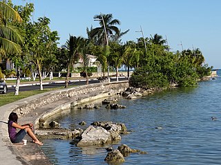
Bacalar is the municipal seat and largest city in Bacalar Municipality in the Mexican state of Quintana Roo, about 40 kilometres (25 mi) north of Chetumal, at 18° 40' 37" N, 88° 23' 43" W. In the 2010 census the city had a population of 11,084 people. At that time it was still a part of Othón P. Blanco, and was its second-largest city (locality), after Chetumal.

Puerto Morelos is a town and seaport in Quintana Roo, Mexico's easternmost state, on the Yucatán Peninsula. The town is located in the northeast of the state, about 36 km (22 mi) south of the resort city of Cancún, and about 30 km (19 mi) north of the city of Playa del Carmen.

Benito Juárez is one of the eleven municipalities of the Mexican state of Quintana Roo. Most of its population reside in the municipal seat, Cancún. It is named after the 19th century president and statesman Benito Juárez.

Solidaridad is one of the eleven municipalities that make up the Mexican state of Quintana Roo. Its municipal seat is the town of Playa del Carmen.

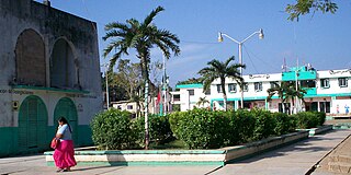
Felipe Carrillo Puerto is the municipal seat and largest city in Felipe Carrillo Puerto Municipality in the Mexican state of Quintana Roo. According to the 2010 census, the city's population was 25,744 persons, mostly of Maya descent.

Tizimín Municipality is one of the 106 municipalities of Yucatán with a municipal seat of the same name. The municipality is located in the north-east of the Mexican state of Yucatán, and it is the largest municipality in the state with a territory that is 11% of the total area of the state. As of 2005 it also has the second largest population of any municipality in the state, the largest being Mérida and the third largest being Valladolid.

Calakmul is a municipality in the Mexican state of Campeche, situated in the central part of the Yucatán Peninsula.
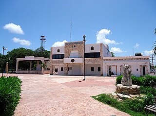
Othón P. Blanco is one of the eleven subdivisions (municipios) of the Mexican state of Quintana Roo. It had a 2010 census population of 244,553 persons. Its municipal seat is the city of Chetumal, which also serves as the state capital. The municipality is named after Othón P. Blanco Núñez de Cáceres.

Muyil was one of the earliest and longest inhabited ancient Maya sites on the eastern coast of the Yucatan Peninsula. It is located approximately 15 kilometres (9.3 mi) south of the coastal site of Tulum, in the Municipality of Felipe Carrillo Puerto in the state of Quintana Roo, Mexico. Artifacts found here date back from as early as 350 BC. to as late as 1200-1500 AD. The ruins of Muyil are an example of Peten architecture, like those found in southern Mayan sites with their steep walled pyramids such as Tikal in Guatemala. It is situated on the Sian Ka'an lagoon, a name meaning "Where the Sky is Born". Muyil was located along a trade route on the Caribbean once accessible via a series of canals. Among the most commonly traded goods were Jade, obsidian, chocolate, honey, feathers, chewing gum, and salt. It is believed that throughout much of its history, Muyil had strong ties to the center of Coba located some 44 kilometres (27 mi) the north / northwest. The 2010 federal census reported a population of 191 inhabitants in the locality.
Tulum Municipality is one of the eleven municipalities that make up the Mexican state of Quintana Roo. It became one of the newest municipalities in the country when it was formed on March 13, 2008, when it was separated from Solidaridad Municipality.

José María Morelos is one of the ten municipalities that make up the Mexican state of Quintana Roo.
Lázaro Cárdenas is one of the eleven municipalities that make up the Mexican state of Quintana Roo. Its municipal seat is the town of Kantunilkín, which was founded on 10 October 1859. Its borders are, to the west, the municipalities of Tizimín and Chemax in the state of Yucatán, to the east the municipalities of Isla Mujeres and Benito Juárez, and to the south Solidaridad.

Isla Mujeres is one of the eleven municipalities of the Mexican state of Quintana Roo, on the Yucatán Peninsula. Most of the municipality is located on the mainland in the northeastern corner of the state. Its municipal seat, also called Isla Mujeres, is a small town situated on the island from which it takes its name, about 13 kilometres (8.1 mi) northeast of Cancún in the Caribbean Sea. It is the easternmost municipal seat in Mexico. In the 2010 census, the town had a population of 16,203 inhabitants.

X-Hazil Sur is a town in the Mexican state of Quintana Roo, Mexico, localized in state center, in the municipality of Felipe Carrillo Puerto, 1 hour far from the capital of the state. The population was 1,422 inhabitants at the 2010 census.
Quintana Roo Municipality is one of the 106 municipalities in the Mexican state of Yucatán containing (139.24 km2) of land and located roughly 104 km east of the city of Mérida.

Puerto Morelos is one of the eleven municipalities of the Mexican state of Quintana Roo, on the Yucatán Peninsula. It was formed in 2016 from the localities of Puerto Morelos, Leona Vicario and Central Vallarta previously belonging to the municipality of Benito Juárez. In the 2010 census, these three localities recorded a total of 15,725 inhabitants.
Tihosuco is a town in the Mexican state of Quintana Roo, Mexico, localized in state center, in the municipality of Felipe Carrillo Puerto. The population was 4,994 inhabitants at the 2010 census.
Tepich is a town in the Mexican state of Quintana Roo, Mexico, localized in state center, in the municipality of Felipe Carrillo Puerto. The population was 2,753 inhabitants at the 2010 census.
Chunhuhub is a town in the Mexican state of Quintana Roo, Mexico, localized in state center, in the municipality of Felipe Carrillo Puerto. The population was 4,644 inhabitants at the 2010 census.