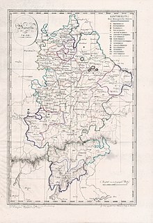
Nürnberger Land is a Landkreis (district) in Bavaria, Germany. It is bounded by the districts of Forchheim, Bayreuth, Amberg-Sulzbach, Neumarkt, Roth and Erlangen-Höchstadt, and by the city of Nuremberg.

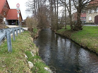
The Pegnitz is a river in Franconia in the German federal state of Bavaria.

Lauf an der Pegnitz is a town to the East of Nuremberg, Germany. It is the capital of the district Nürnberger Land, in Bavaria. It is in the valley of the River Pegnitz, which flows through the town.

Tirschenreuth is the capital city of the district of Tirschenreuth. It is located in the northeast of Bavaria, very close to the Czech-Bavarian border.
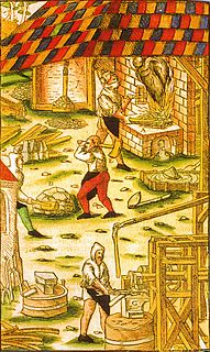
A hammer mill, hammer forge or hammer works was a workshop in the pre-industrial era that was typically used to manufacture semi-finished, wrought iron products or, sometimes, finished agricultural or mining tools, or military weapons. The feature that gave its name to these workshops was the water-driven trip hammer, or set of hammers, used in the process. The shaft, or 'helve', of the hammer was pivoted in the middle and the hammer head was lifted by the action of cams set on a rotating camshaft that periodically depressed the end of the shaft. As it rose and fell, the head of the hammer described an arc. The face of the hammer was made of iron for durability.

Röthenbach an der Pegnitz is a town in the district of Nürnberger Land, in Bavaria, Germany. It is situated on the Pegnitz River, 4 km southwest of Lauf an der Pegnitz, and 12 km east of Nuremberg (centre).

Velden is a town in the district Nürnberger Land, in Bavaria, Germany. It is situated on the Pegnitz River, 16 km south of Pegnitz, and 36 km northeast of Nuremberg (centre).

The Rednitz is a 46 km (29 mi) long river in Franconia, Germany, tributary of the Regnitz. The Rednitz is formed by the confluence of the rivers Franconian Rezat and Swabian Rezat, in Georgensgmünd. The Rednitz flows north through Roth bei Nürnberg, Schwabach and the southwestern quarters of Nuremberg. The Rednitz joins the Pegnitz to form the Regnitz in Fürth.

Heroldsberg is a municipality in the district of Erlangen-Höchstadt, in Bavaria, Germany. It is located eleven kilometers north-east from the city of Nuremberg and 23 kilometers east from Erlangen and is the headquarters of Schwan-Stabilo.
The Ranna–Auerbach railway was an 8-kilometre long branch line or Lokalbahn in Bavaria in southern Germany, which linked Auerbach in der Oberpfalz via Ranna to the Nuremberg–Cheb railway. It replaced the cable railway built in 1882 from the Maxhütte to Sulzbach-Rosenberg, which until then had transported mineral resources in the region around Auerbach to the railway.
The Nuremberg–Schwandorf railway is a 93.7 km long railway from Nuremberg, running along the Pegnitz river, to Hersbruck and continuing via Neukirchen bei Sulzbach-Rosenberg and Amberg to Schwandorf in the German state of Bavaria. It runs parallel to the Nuremberg–Cheb line between Nuremberg and Pommelsbrunn and this section is known as the Left Pegnitz line. It was opened in 1859 and is one of the oldest railways in Germany.
The Hersbruck–Pommelsbrunn railway is a 5.4 km long mainline railway in the German state of Bavaria, which connects the Nuremberg–Cheb and Nuremberg–Schwandorf lines to each other.

The Püttlach is a left tributary of the River Wiesent. It is about 27 km (17 mi) long and flows through the Bavarian region of Franconian Switzerland in Germany.

Högenbach is a river of Bavaria, Germany. It flows into the Pegnitz, near Pommelsbrunn.
Schnaittach is a river of Bavaria, Germany. It is a right tributary of the Pegnitz near Neunkirchen am Sand. It passes through the town Schnaittach.
Sittenbach is a river of Bavaria, Germany. It flows into the Pegnitz near Hersbruck.

The Zipser Mühlbach is a small river in Bavaria, Germany. It flows into the Fichtenohe north of the town Pegnitz.
The Rezatkreis, between 1806 and 1837, was one of the 15 districts of the Kingdom of Bavaria. Its name meant in German the “District of the Rezat” because the Fränkische Rezat River ran through it. It was the predecessor of the Regierungsbezirks Mittelfranken. Its center was Anspach.
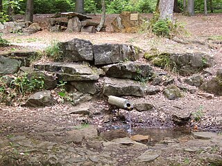
The Red Main Spring is the source of the Red Main river, the left-hand and southern headstream of the River Main in Germany. It is located in the Lindenhardt Forest, ten kilometres south of Bayreuth near Hörlasreuth at a height of 581 m above sea level (NN) on the southern slopes of the Tannenberg (596 m). Although the Red Main is several kilometres longer than the Weiße Main, the stronger White Main Spring is seen as the source of the Main itself.
The Bavarian Iron Route or, less commonly, Bavarian Iron Road is a major holiday route in southern Germany which is steeped in history. Running for 120 kilometres, it links numerous historic industrial sites, covering a period of several centuries, with cultural and natural monuments.
