Solomon Islands is a sovereign state in the Melanesia subregion of Oceania in the western Pacific Ocean. This page is about the history of the nation state rather than the broader geographical area of the Solomon Islands archipelago, which covers both Solomon Islands and Bougainville Island, a province of Papua New Guinea. For the history of the archipelago not covered here refer to the former administration of the British Solomon Islands Protectorate, the North Solomon Islands and the History of Bougainville.

Guadalcanal is the principal island in Guadalcanal Province of Solomon Islands, located in the southwestern Pacific Ocean, northeast of Australia. It is the largest island in the Solomons by area and the second-largest by population. The island is mainly covered in dense tropical rainforest and has a mountainous hinterland.

Solomon Islands, also known simply as the Solomons, is a country consisting of six major islands and over 900 smaller islands in Melanesia, part of Oceania, to the northeast of Australia. It is directly adjacent to Papua New Guinea to the northwest, Australia to the southwest, New Caledonia and Vanuatu to the southeast, Fiji, Wallis and Futuna, and Tuvalu to the east, and Nauru and the Federated States of Micronesia to the north. It has a total area of 28,896 square kilometres, and a population of 734,887 according to the official estimates for mid 2023. Its capital, Honiara, is located on the largest island, Guadalcanal. The country takes its name from the wider area of the Solomon Islands archipelago, which is a collection of Melanesian islands that also includes the Autonomous Region of Bougainville, but excludes the Santa Cruz Islands.

The flag of Grenada consists of two yellow triangles at the top and bottom and two green triangles at the hoist and fly. These are surrounded by a red border charged with six five-pointed yellow stars – three at the top centre and three at the bottom centre – along with an additional star on a red disc at the centre and a nutmeg at the hoist triangle. Adopted in 1974 to replace the temporary design used since the islands became an Associated State of the United Kingdom, it has been the flag of Grenada since the country gained independence that year. The representation of a nutmeg is symbolic of the islands' primary export, and was the one feature from the previous flag that was preserved.

The flag of Saint Vincent and the Grenadines is a Canadian pale triband consisting of blue, gold, and green bands charged with three green diamonds at the middle. Adopted in 1985 to replace a similar design used from the time of independence, it has been the flag of Saint Vincent since that year. The design of the present flag entailed substituting the country's coat of arms on a breadfruit leaf with the diamonds. They are a reference to both the letter "V", which is the first letter of the country's name, and its nickname as the "Gems of the Antilles" and "Jewels of the Caribbean". Accordingly, the flag itself has been given the moniker of "The Gems".

In vexillography, the canton is a rectangular emblem placed at the top left of a flag, usually occupying up to a quarter of a flag's area. The canton of a flag may be a flag in its own right. For instance, British ensigns have the Union Jack as their canton, as do their derivatives such as the national flags of Australia and New Zealand.

The Regional Assistance Mission to Solomon Islands (RAMSI), also known as Operation Helpem Fren, Operation Anode and Operation Rata, was created in 2003 in response to a request for international aid by the Governor-General of Solomon Islands. Helpem Fren means "help a friend" in Solomon Islands Pidgin. The mission officially ended on 30 June 2017.
Solomon Islands is divided into nine provinces. The national capital, Honiara, on the island of Guadalcanal, is separately governed as the country's Capital Territory.

Malaita is the primary island of Malaita Province in Solomon Islands. Malaita is the most populous island of the Solomon Islands, with a population of 161,832 as of 2021, or more than a third of the entire national population. It is also the second largest island in the country by area, after Guadalcanal.

The British Solomon Islands Protectorate was first declared over the southern Solomon Islands in June 1893, when Captain Herbert Gibson of HMS Curacoa, declared the southern islands a British protectorate.

Santa Isabel is the largest island in Isabel Province, Solomon Islands. It is also the longest island, with the third largest surface area, in the country.
The South Sea Evangelical Church (SSEC) is an evangelical, Pentecostal church in Solomon Islands. In total, 17% of the population of Solomon Islands adheres to the church, making it the third most common religious affiliation in the country behind the Anglican Church of Melanesia and the Roman Catholic Church. The SSEC is particularly popular on Malaita, the most populous island, where 47% of its members live; there are also smaller populations in Honiara and elsewhere on Guadalcanal, on Makira, and in other provinces.
The following outline is provided as an overview of and topical guide to Solomon Islands:

Honiara is the capital and largest city of Solomon Islands, situated on the northwestern coast of Guadalcanal. As of 2021, it had a population of 92,344 people. The city is served by Honiara International Airport and the seaport of Point Cruz, and lies along the Kukum Highway.

The Royal Solomon Islands Police Force (RSIPF) is the national police force of Solomon Islands and in January 2015 had an establishment of approximately 1,153 officers and 43 police stations across the country.

Point Cruz is a peninsula in the center of Honiara, on Guadalcanal Island. Honiara is the capital city of the Solomon Islands. Point Cruz is located on the Tandai Highway, and is ¼ mile north of the Solomon Islands Parliament Building. Point Cruz is in the Honiara City Council ward of Cruz, and is East of Town Ground and West of Tuvaruhu.
Charles Dausabea was a Solomon Islands politician.

On 5 June 2000, a coup d'état occurred in Solomon Islands, in the capital of Honiara, in which the prime minister, Bartholomew Ulufa’alu, was taken hostage by militants of the Malaita Eagle Force. The event came as a result of longstanding ethnic tensions between the province that saw a rise in armed political groups from the late 1990s.
The following lists events that happened during 2020 in the Solomon Islands.
The following lists events that happened during 2020 in the Solomon Islands.

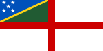
 The initial winning design of the 1975 contest.