Protected areas of Solomon Islands

Last updated
Vangunu island as seen from space; Marovo Lagoon can be seen north of the island. Vangunu Island NASA.jpg
Vangunu island as seen from space; Marovo Lagoon can be seen north of the island.

Protected areas of Solomon Islands include marine protected areas that encompass coral reefs, lagoons, and seagrass meadows. East Rennell, which includes Lake Tegano (Te Nggano), is the only area in the Solomon Islands (the Solomons) listed by UNESCO as a World Heritage Site. As of April 2024, the Solomons have not nominated any wetlands under the Convention on Wetlands of International Importance (known as the Ramsar Convention).

Contents

The exclusive economic zone of the Solomons spans 1,589,477 km2 (613,701 sq mi) of the Pacific Ocean. The Solomons are part of the Coral Triangle, the region of the western Pacific with the world's greatest diversity of corals and coral reef species. The recognizable reef systems in the Solomons include fringing reef, patch reef, barrier reef, atoll reef, and lagoon environment. [1] The Coral reefs of the Solomons total 6,750 km2 (2,610 sq mi). [2] As of 2020, there are 113 locally managed marine areas (LMMA) containing an estimated 155 no-take zones in the Solomons. The largest LMMA, with a contiguous 13 km (10 mi) no-take zone, is on Tetepare Island. [3]

Queen Elizabeth II National Park

The Queen Elizabeth II National Park was established in 1953 as a 15,000-acre (61 km2) park near the capital Honiara on Guadalcanal. [4] It is the only national park in the Solomons. Guadalcanal people disputed the government's right to use the land that became the park, occupyied parts of the park and cleared and farmed the land. In 1973 the park was reduced to 2,000 acres (8.1 km2) as it was recognised that much of it had been degraded by illegal logging and the effects of illegal settlements. [4]

Marine protected areas and conservation areas

Tridacna gigas, with the mantle showing Giant clam or Tridacna gigas.jpg
Tridacna gigas , with the mantle showing
Pocillopora verrucosa Pocilloporaverrucosa.jpg
Pocillopora verrucosa
Favites pentagona Favites pentagona 1.JPG
Favites pentagona

As of April 2024, there are 38 marine protected areas, marine conservation areas and community conservation areas in the Solomons, which are managed by local communities, as well as two forest reserves. The World Database on Protected Areas (WDPA) includes the following protected areas in the Solomons: [5]

World Heritage listed areas

Te Nggano, East Rennell Dugout canoe Rennell.jpg
Te Nggano, East Rennell

As of April 2024, East Rennell is the only area in the Solomons listed by UNESCO as a World Heritage Site. [10] East Rennell is the southern portion of Rennell Island, which is the largest raised coral atoll in the world. The area in East Rennell surrounding Lake Tegano (Te Nggano) contains many endemic species. [11] Lake Tegano (Te Nggano) is a former lagoon and the largest lake on an island in the Pacific Ocean. [12]

Other sites in the Solomons are on UNESCO's Tentative List, as important heritage and natural sites that are being considered for inclusion on the World Heritage List: [13]

SiteImageLocation Criteria Area
ha (acre)
Year of submissionDescription
Marovo - Tetepare Complex Marovo Lagoon (16 August 2008).jpg Western, Flag of the Solomon Islands.svg  Solomon Islands

8°29′S158°04′E / 8.48°S 158.07°E / -8.48; 158.07 (Marovo - Tetepare Complex)

Mixed (iii)(v)(vi)(vii)(viii)(ix)(x)2008 [14]
Tropical Rainforest Heritage of Solomon Islands Sunlight Channel Tillotson Cove.jpg Choiseul, Guadalcanal, Makira-Ulawa, Western, Flag of the Solomon Islands.svg  Solomon Islands

7°08′00″S156°57′00″E / 7.133333°S 156.95°E / -7.133333; 156.95 (Tropical Rainforest Heritage of Solomon Islands)

Natural (vii)(ix)(x)2008 [15]

Areas of high biodiversity and conservation value

NASA picture of the three atolls forming the Indispensable Reef; North Reef is right STS088-706-64 indispensable.PNG
NASA picture of the three atolls forming the Indispensable Reef; North Reef is right
NASA picture of Tikopia Tikopia ISS002.PNG
NASA picture of Tikopia

A total of 12 offshore sites and 53 inshore sites have been identified as Key Biodiversity Areas (KBAs) - areas of high biodiversity and conservation. [6] The highest-scoring sites were Marovo Lagoon and the Arnavon Community Marine Conservation Area. [6] The key offshore sites are Roncador Reef, Ontong Java Atoll, Tikopia Island, Nendö and Vanikoro in the Santa Cruz group and underwater seamounts, hydrothermal vents and submarine volcanoes, including Kavachi, an active submarine volcano located south of Vangunu Island. [6]

KBAs include:

Related Research Articles

<span class="mw-page-title-main">Geography of the Solomon Islands</span>

Solomon Islands is an island country in the South Pacific Ocean, that lies east of Papua New Guinea.

<span class="mw-page-title-main">Atoll</span> Ring-shaped coral reef

An atoll is a ring-shaped island, including a coral rim that encircles a lagoon. There may be coral islands or cays on the rim. Atolls are located in warm tropical or subtropical parts of the oceans and seas where corals can develop. Most of the approximately 440 atolls in the world are in the Pacific Ocean.

<span class="mw-page-title-main">Lagoon</span> Shallow body of water separated from a larger one by a narrow landform

A lagoon is a shallow body of water separated from a larger body of water by a narrow landform, such as reefs, barrier islands, barrier peninsulas, or isthmuses. Lagoons are commonly divided into coastal lagoons and atoll lagoons. They have also been identified as occurring on mixed-sand and gravel coastlines. There is an overlap between bodies of water classified as coastal lagoons and bodies of water classified as estuaries. Lagoons are common coastal features around many parts of the world.

<span class="mw-page-title-main">New Georgia Islands</span> Island group

The New Georgia Islands are part of the Western Province of Solomon Islands. They are located to the northwest of Guadalcanal. The larger islands are mountainous and covered in rain forest. The main islands are New Georgia, Vella Lavella, Kolombangara, Ghizo, Vangunu, Rendova and Tetepare. They are surrounded by coral reefs and include the Marovo Lagoon.

<span class="mw-page-title-main">Rennell Island</span> Island in the Solomon Islands

Rennell Island, locally known as Mugaba, is the main island of two inhabited islands that make up the Rennell and Bellona Province in the nation state of Solomon Islands. Rennell Island has a land area of 660 square kilometres (250 sq mi) that is about 80 kilometres (50 mi) long and 14 kilometres (8.7 mi) wide. It is the second largest raised coral atoll in the world with the largest lake in the insular Pacific, Lake Tegano, a lake that is listed as a World Heritage Site. Rennell Island has a population of about 1,840 persons of Polynesian descent who primarily speak Rennellese, Pijin and some English. Rennell and Bellona Islands are two of the few islands in the otherwise Melanesian Solomon Islands archipelago classified as a Polynesian outlier; others being Sikaiana, Ontong Java, Tikopia, Anuta, Duff Islands, and some Reef Islands.

<span class="mw-page-title-main">East Rennell</span> Eastern half of Rennell Island in the Solomon Islands

East Rennell is the southern portion of Rennell Island in the Solomon Islands which is designated a UNESCO World Heritage Site. Rennell is the largest raised coral atoll in the world and the area in East Rennell surrounding Lake Tegano contains many endemic species.

<span class="mw-page-title-main">Vangunu</span> Island in Solomon Islands

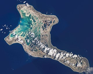
Vangunu is an island, part of the New Georgia Islands in Western Province, in the independent nation of Solomon Islands. It is located between New Georgia and Nggatokae Island. To the north and east of the island is Marovo Lagoon. The island has an area of 509 square kilometres (197 sq mi).

<span class="mw-page-title-main">Marovo Lagoon</span>

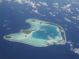
Marovo Lagoon is the largest saltwater lagoon in the world. Located in the New Georgia Islands, surrounded by Vangunu Island and Nggatokae Island, both extinct volcanic islands, at 8.48°S 158.07°E. It is part of the Solomon Islands. It encompasses 700 km2 (270 sq mi) and is protected by a double barrier reef system. Marovo Lagoon is identified as an area with high biodiversity and conservation values.

<span class="mw-page-title-main">Solomon Archipelago</span> A marine ecoregion of the Pacific Ocean

The Solomon Archipelago is a terrestrial ecoregion and marine ecoregion in the Pacific Ocean. It includes the tropical ocean waters surrounding most of the Solomon Islands archipelago, and includes Bougainville Island and Buka Island of Papua New Guinea and their surrounding waters.

<span class="mw-page-title-main">Apo Reef</span> Coral reef in the Philippines

Apo Reef is a coral reef system in the Philippines situated in the western waters of Occidental Mindoro province in the Mindoro Strait. Encompassing 34 square kilometres (13 sq mi), it is considered the world's second-largest contiguous coral reef system, and is the largest in the country. The reef and its surrounding waters are protected areas administered as the Apo Reef Natural Park (ARNP). It is one of the best known and most popular diving regions in the country, and is in the tentative list for UNESCO World Heritage Sites.

<span class="mw-page-title-main">Indispensable Reefs</span> Three atolls in Rennell and Bellona Province, Solomon Islands

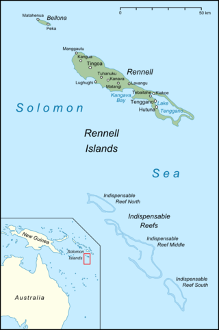
The Indispensable Reefs are a chain of three large coral atolls in the Coral Sea. They are located about 50 km (30 mi) south of Rennell Island. The chain stretches over a length of 114 km (71 mi) and its average width is 18 km (11 mi).

Arnarvon Islands are a group of islands in Solomon Islands. They are located in Isabel Province and nearby to Wagina Island in Choiseul Province.

<span class="mw-page-title-main">Phoenix Islands Protected Area</span> Marine protected area in central Kiribati

The Phoenix Islands Protected Area (PIPA) is located in the Republic of Kiribati, an ocean nation in the central Pacific approximately midway between Australia and Hawaii. PIPA constitutes 11.34% of Kiribati's exclusive economic zone (EEZ), and with a size of 408,250 km2 (157,630 sq mi), it is one of the largest marine protected areas (MPA) and one of the largest protected areas of any type on Earth. The PIPA was also designated as the world's largest and deepest UNESCO World Heritage Site in 2010.

<span class="mw-page-title-main">Lighthouse Reef</span> Atoll off the coast of Belize

Lighthouse Reef is an atoll in the Caribbean Sea, the easternmost part of the Belize Barrier Reef and one of its three atolls, the other two being Turneffe Atoll and Glover's Reef. Lighthouse Reef is located about 80 kilometres (50 mi) southeast of Belize City. The atoll is of oblong shape, approximately 35 kilometres (22 mi) long from north to south, and about 8 kilometres (5.0 mi) wide. It forms a shallow sandy lagoon with an area of 120 square kilometres (46 sq mi) and a depth between 2 and 6 metres deep.

<span class="mw-page-title-main">Coral reefs of Kiribati</span> Pacific Ocean Island chain

The Coral reefs of Kiribati consists of 32 atolls and one raised coral island, Banaba, which is an isolated island between Nauru and the Gilbert Islands. The islands of Kiribati are dispersed over 3.5 million km2 (1.4 million sq mi) of the Pacific Ocean and straddle the equator and the 180th meridian, extending into the eastern and western hemispheres, as well as the northern and southern hemispheres. 21 of the 33 islands are inhabited. The groups of islands of Kiribati are:

<span class="mw-page-title-main">Coral reefs of the Solomon Islands</span>

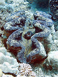
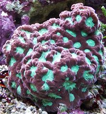
The Coral reefs of the Solomon Islands consists of six major islands and over 986 smaller islands, in Oceania, to the east of Papua New Guinea and northwest of Vanuatu. The Solomon Islands lie between latitudes 5° and 13°S, and longitudes 155° and 169°E. The distance between the westernmost and easternmost islands is about 1,500 km (930 mi). The Santa Cruz Islands are situated north of Vanuatu and are especially isolated at more than 200 km (120 mi) from the other islands. The Solomon Islands has the 22nd largest Exclusive Economic Zone of 1,589,477 km2 (613,701 sq mi) of the Pacific Ocean.

<span class="mw-page-title-main">Protected areas of Kiribati</span> Protected areas in Kiribati

Protected areas of Kiribati include marine protected areas managed by the Environment and Conservation Division, of the Kiribati Ministry of Environment, Lands and Agricultural Development. Kiribati, in partnership with the New England Aquarium and Conservation International (CI), manages the Phoenix Islands Protected Area (PIPA), which is a World Heritage Site that was established in 2006, and is the second largest of the world's marine protected areas. The U.S. administered Pacific Remote Islands Marine National Monument is currently the world's largest designated marine protected area (MPA), and is to the north and north-east of the PIPA.

<span class="mw-page-title-main">Protected areas of Tuvalu</span> Protected areas in Tuvalu

Protected areas of Tuvalu consist of protected areas located within the central Pacific country of Tuvalu and its territorial waters. One such area is the Funafuti Conservation Area, which is a marine protected area on the western reef area of Funafuti atoll.

References

  1. Kool, J., T. Brewer, M. Mills, and R. Pressey. (2010). Ridges to Reefs Conservation Plan for Solomon Islands (Report). Townsville: ARC Centre of Excellence for Coral Reef Studies. Retrieved 8 April 2024.{{cite report}}: CS1 maint: multiple names: authors list (link)
  2. Burke, L., Reytar, K., Spalding, M., Perry, A., Knight, M., Kushner, B., Starkhouse, B., Waite, R. and White, A. (2012). Reefs at Risk Revisited in the Coral Triangle (PDF) (Report). DC: World Resources Institute. Retrieved 31 March 2021.{{cite report}}: CS1 maint: multiple names: authors list (link)
  3. Denley D., Metaxas A., Scheibling R. (2020). "Subregional variation in cover and diversity of hard coral (Scleractinia) in the Western Province, Solomon Islands following an unprecedented global bleaching event". PLOS ONE. 15 (11): e0242153. Bibcode:2020PLoSO..1542153D. doi: 10.1371/journal.pone.0242153 . PMC   7657522 . PMID   33175873.{{cite journal}}: CS1 maint: multiple names: authors list (link)
  4. 1 2 "Solomon Islands Historical Encyclopaedia 1893-1978". Queen Elizabeth National Park. 2020.
  5. "UNEP-WCMC (2024). Protected Area Profile for Tuvalu from the World Database on Protected Areas". Protected Planet - Cambridge, UK: UNEP-WCMC. April 2024. Retrieved 7 April 2024.
  6. 1 2 3 4 5 6 7 8 9 10 11 12 13 Ceccarelli DM, Wini-Simeon, Sullivan, Wendt, Vave-Karamui, Masu, Nicolay-Grosse Hokamp, Davey, Fernandes (2018). Biophysically Special, Unique Marine Areas of the Solomon Islands (PDF) (Report). MACBIO, (GIZ, IUCN, SPREP), Suva. ISBN   978-0-9975451-6-6 . Retrieved 8 April 2024.{{cite report}}: CS1 maint: multiple names: authors list (link)
  7. "Komarindi catchment conservation area, Solomon Islands : project preparation document". Secretariat of the Pacific Regional Environment Programme (SPREP) South Pacific Biodiversity Conservation Programme (SPBCP). 1996. Retrieved 7 April 2024.
  8. "Tetepare - the last wild island". tetepare.org.
  9. 1 2 Carlton, R., Dempsey, A., Lubarsky, K., Akao, I., Faisal, M., and Purkis, S. (2020). Global Reef Expedition: Solomon Islands (Final Report) (Report). The Khaled bin Sultan Living Oceans Foundation. ISBN   978-0-9975451-6-6 . Retrieved 31 March 2021.{{cite report}}: CS1 maint: multiple names: authors list (link)
  10. "World Heritage List". UNESCO World Heritage Centre. 7 April 2024. Retrieved 7 April 2024.
  11. World Heritage Committee. "World Heritage Committee inscribes East Rennell on the List of World Heritage in Danger". United Nations Educational, Scientific and Cultural Organization. Retrieved 13 August 2013.
  12. World Heritage Committee. "East Rennell". United Nations Educational, Scientific and Cultural Organization. Retrieved 8 April 2024.
  13. Glossary, UNESCO, retrieved 8 April 2024
  14. "Marovo - Tetepare Complex". UNESCO World Heritage Centre. Retrieved 2021-04-02.
  15. "Tropical Rainforest Heritage of Solomon Islands". UNESCO World Heritage Centre. Retrieved 2021-04-02.