Florenceville, Iowa

Last updated
Florenceville, Iowa
Unincorporated community
USA Iowa location map.svg
Red pog.svg
Florenceville, Iowa
Coordinates: 43°29′57″N92°07′58″W / 43.49917°N 92.13278°W / 43.49917; -92.13278 Coordinates: 43°29′57″N92°07′58″W / 43.49917°N 92.13278°W / 43.49917; -92.13278
Country United States
State Iowa
County Howard
Elevation 1,135 ft (346 m)
Time zone Central (CST) (UTC-6)
  Summer (DST) CDT (UTC-5)
Area code(s) 563
GNIS feature ID 456643 [1]

Florenceville is an unincorporated community located in Howard County, Iowa, United States. [1] It is adjacent to the village of Granger, Minnesota.

Unincorporated area Region of land not governed by own local government

In law, an unincorporated area is a region of land that is not governed by a local municipal corporation; similarly an unincorporated community is a settlement that is not governed by its own local municipal corporation, but rather is administered as part of larger administrative divisions, such as a township, parish, borough, county, city, canton, state, province or country. Occasionally, municipalities dissolve or disincorporate, which may happen if they become fiscally insolvent, and services become the responsibility of a higher administration. Widespread unincorporated communities and areas are a distinguishing feature of the United States and Canada. In most other countries of the world, there are either no unincorporated areas at all, or these are very rare; typically remote, outlying, sparsely populated or uninhabited areas.

Howard County, Iowa County in the United States

Howard County is a county located in the US state of Iowa. As of the 2010 census, the population was 9,566. The county seat is Cresco. The county was founded in 1851; it was named for General Tilghman Ashurst Howard, a Representative of Indiana.

Iowa State of the United States of America

Iowa is a state in the Midwestern United States, bordered by the Mississippi River to the east and the Missouri River and Big Sioux River to the west. It is bordered by six states; Wisconsin to the northeast, Illinois to the east, Missouri to the south, Nebraska to the west, South Dakota to the northwest and Minnesota to the north.

Contents

Geography

Florenceville is located at 43°29'54" North, 92°7'58" West. Florenceville is in the northwest portion of section 10, Albion Township, Howard County. The Iowa-Minnesota state line forms the village's northern border. The Upper Iowa River runs through the village.

Upper Iowa River tributary of the Mississippi River

The Upper Iowa River is a 156-mile-long (251 km) tributary of the Mississippi River in the upper Midwest of the United States.

The area features a Karst topography. Niagara Cave, located a few miles northeast of the village, is one of the largest caves in the Midwest.

Cave Natural underground space large enough for a human to enter

A cave or cavern is a natural void in the ground, specifically a space large enough for a human to enter. Caves often form by the weathering of rock and often extend deep underground. The word cave can also refer to much smaller openings such as sea caves, rock shelters, and grottos, though strictly speaking a cave is exogene, meaning it is deeper than its opening is wide, and a rock shelter is endogene.

Midwestern United States region that includes parts of Canada and the United States

The Midwestern United States, also referred to as the American Midwest, Middle West, or simply the Midwest, is one of four census regions of the United States Census Bureau. It occupies the northern central part of the United States. It was officially named the North Central Region by the Census Bureau until 1984. It is located between the Northeastern United States and the Western United States, with Canada to its north and the Southern United States to its south.

History

Florenceville, platted as Florence, sprang up in the mid-19th century. Originally, it had a mill, a post office and a general store. Now, mostly houses remain. The village has a Methodist church that closed in the 1960s. An annual reunion service brings former and current residents back together for a Sunday in the summer. The church building is now owned and maintained by the Howard County Historical Society.

Plat scale map showing the divisions of a piece of land

In the United States, a plat is a map, drawn to scale, showing the divisions of a piece of land. United States General Land Office surveyors drafted township plats of Public Lands Surveys to show the distance and bearing between section corners, sometimes including topographic or vegetation information. City, town or village plats show subdivisions into blocks with streets and alleys. Further refinement often splits blocks into individual lots, usually for the purpose of selling the described lots; this has become known as subdivision.

A post office is a public department that provides a customer service to the public and handles their mail needs. Post offices offer mail-related services such as acceptance of letters and parcels; provision of post office boxes; and sale of postage stamps, packaging, and stationery. In addition, many post offices offer additional services: providing and accepting government forms, processing government services and fees, and banking services. The chief administrator of a post office is called a postmaster.

The United Methodist Church (UMC) is a mainline Protestant denomination and a major part of Methodism. In the 19th century, its main predecessor, the Methodist Episcopal Church, was a leader in evangelicalism. The present denomination was founded in 1968 in Dallas, Texas, by union of The Methodist Church and the Evangelical United Brethren Church. The UMC traces its roots back to the revival movement of John and Charles Wesley in England, as well as the Great Awakening in the United States. As such, the church's theological orientation is decidedly Wesleyan. It embraces both liturgical and evangelical elements.

Tourism and recreation

The village features a county park popular for softball games. An Amish community thrives in the area and tours of Amish country are available.

Softball Softball is a variant of baseball played with a larger ball

Softball is a variant of baseball played with a larger ball on a field that has base lengths of 60 feet, a pitcher's mound that ranges from 35-43 feet away from home plate, and a homerun fence that is 220 feet away from home plate.. It was invented in 1887 in Chicago, Illinois, United States as an indoor game. The game moves at a faster pace than traditional baseball. There is less time for the base runner to get to first while the opponent fields the ball; yet, the fielder has less time to field the ball while the opponent is running down to first base. The name softball was given to the game in 1926, because the ball used to be soft, however in modern day usage, the balls are hard.

Amish group of traditionalist Christian church fellowships

The Amish are a group of traditionalist Christian church fellowships with Swiss German Anabaptist origins. They are closely related to, but distinct from, Mennonite churches. The Amish are known for simple living, plain dress, and reluctance to adopt many conveniences of modern technology.

Related Research Articles

Effigy Mounds National Monument national monument in Iowa, USA

Effigy Mounds National Monument preserves more than 200 prehistoric mounds built by Native Americans. Numerous effigy mounds are shaped like animals, including bears and birds. These were built mostly in the first millennium, by peoples of the Woodland Culture. In 2017, they were featured in the America the Beautiful Quarters Program.

Todd County, Minnesota County in the United States

Todd County is a county in the U.S. state of Minnesota. As of the 2010 United States Census, the population was 24,895. Its county seat is Long Prairie.

Fillmore County, Minnesota County in the United States

Fillmore County is a county in the U.S. state of Minnesota. As of the 2010 United States Census, the population was 20,866. Its county seat is Preston.

Hart County, Kentucky County in the United States

Hart County is a county located in the Commonwealth of Kentucky. As of the 2010 census, the population was 18,199. Its county seat is Munfordville. Hart County is a prohibition or dry county.

Buchanan County, Iowa County in the United States

Buchanan County is a county located in the U.S. state of Iowa. As of the 2010 census, the population was 20,958. Its county seat is Independence. The county was created in 1837 and was named in honor of Senator James Buchanan, the 15th President of the United States.

Kalona, Iowa City in Iowa, United States

Kalona is a city in Washington County, Iowa, United States. It is part of the Iowa City, Iowa Metropolitan Statistical Area. The population was 2,363 at the 2010 census. Kalona is the second largest city in Washington County.

Decorah, Iowa City in Iowa, United States

Decorah is a city in and the county seat of Winneshiek County, Iowa, United States. The population was 8,127 at the 2010 census. Decorah is located at the intersection of State Highway 9 and U.S. Route 52, and is the largest community in Winneshiek County.

Harmony, Minnesota City in Minnesota, United States

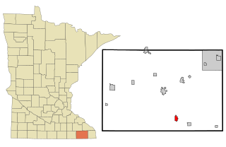
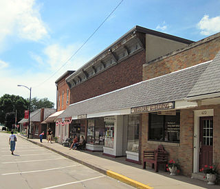
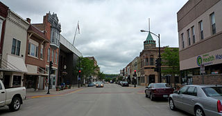
Harmony is a city in Fillmore County, Minnesota, United States. The population was 1,020 at the 2010 census. The town bills itself as the "Biggest Little Town in Southern Minnesota" and features the largest Amish community in the state.

German language in the United States

Over 50 million Americans claim German ancestry, which makes them the largest single claimed ethnic group in the United States. Around 1.06 million people in the United States speak the German language. It is the second most spoken language in North Dakota. In 16 states, it is the most spoken language other than English and Spanish.

Florenceville-Bristol Town in New Brunswick, Canada

Florenceville-Bristol is a town in the northwest part of New Brunswick, Canada. The town is located on the banks of the Saint John River in Carleton County. As of 2016, the population was 1,604.

Amish, Iowa Unincorporated community in Iowa, United States

Amish is an unincorporated community in Johnson County, Iowa, United States. It is part of the Iowa City Metropolitan Statistical Area. The area became known due to the YouTube video “Smokin Big Ole Doinks in Amish” by Young King Dave. Its altitude is 758 feet (231 m), and it lies at 41°32′9″N91°47′12″W.

Greenleafton, Minnesota Unincorporated community in Minnesota, United States

Greenleafton is an unincorporated community in York Township, Fillmore County, Minnesota, United States.

Cold Water Spring State Preserve is a 60-acre (240,000 m2) parcel state preserve protecting a spring that issues from Cold Water Cave, an extensive cave system in Winneshiek County, Iowa and Fillmore County, Minnesota. The spring is a tributary of the Upper Iowa River.

The Fellowship of Evangelical Churches (FEC) is an evangelical body of Christians with an Amish Mennonite heritage that is headquartered in Fort Wayne, Indiana.

Etna, Minnesota Unincorporated community in Minnesota, United States

Etna is an unincorporated community in Bloomfield Township, Fillmore County, Minnesota, United States. Etna is located within ZIP code 55975 based in Spring Valley.

Bryantsburg is an unincorporated community in Buchanan County, Iowa, United States. It is located on Highway 150 north of Independence and south of Hazleton, at 42.579132N, -91.905063W.

The Buchanan Amish affiliation is a subgroup of Amish that was formed in 1914 in Buchanan County, Iowa. It is among the most conservative in the entire Amish world. It is the fourth largest of all Amish affiliation, having almost as many church districts as the Holmes Old Order Amish affiliation. Geographically it is more dispersed than any other Amish affiliation.

References