Howard County, Iowa

Last updated

Howard County
HowardCountyCourthouseCrescoIowa.jpg
Map of Iowa highlighting Howard County.svg
Location within the U.S. state of Iowa
Iowa in United States.svg
Iowa's location within the U.S.
Coordinates: 43°21′27″N92°18′56″W / 43.3575°N 92.315555555556°W / 43.3575; -92.315555555556
CountryFlag of the United States.svg United States
StateFlag of Iowa.svg  Iowa
Founded1851
Named for Tilghman Howard
Seat Cresco
Largest cityCresco
Area
  Total474 sq mi (1,230 km2)
  Land473 sq mi (1,230 km2)
  Water0.4 sq mi (1 km2)  0.08%
Population
 (2020)
  Total9,469
  Density20/sq mi (7.7/km2)
Time zone UTC−6 (Central)
  Summer (DST) UTC−5 (CDT)
Congressional district 1st
Website howardcounty.iowa.gov

Howard County is a county located in the US state of Iowa. As of the 2020 census, the population was 9,469. [1] The county seat is Cresco. [2] The county was founded in 1851; it was named for General Tilghman Ashurst Howard, a Representative of Indiana. [3] [4]

Contents

Geography

According to the U.S. Census Bureau, the county has a total area of 474 square miles (1,230 km2), of which 473 square miles (1,230 km2) is land and 0.4 square miles (1.0 km2) (0.08%) is water. [5]

Major highways

Adjacent counties

Demographics

Historical population
CensusPop.Note
1860 3,168
1870 6,28298.3%
1880 10,83772.5%
1890 11,1823.2%
1900 14,51229.8%
1910 12,920−11.0%
1920 13,7056.1%
1930 13,082−4.5%
1940 13,5313.4%
1950 13,105−3.1%
1960 12,734−2.8%
1970 11,442−10.1%
1980 11,114−2.9%
1990 9,809−11.7%
2000 9,9321.3%
2010 9,566−3.7%
2020 9,469−1.0%
2023 (est.)9,376 [6] −1.0%
U.S. Decennial Census [7]
1790-1960 [8] 1900-1990 [9]
1990-2000 [10] 2010-2018 [11]
Population of Howard County from US census data HowardCountyIowaPop2020.png
Population of Howard County from US census data

2020 census

2022 US Census population pyramid for Howard County from ACS 5-year estimates HowardCountyIA2022PopPyr.png
2022 US Census population pyramid for Howard County from ACS 5-year estimates

The 2020 census recorded a population of 9,469 in the county, with a population density of

2010 census

The 2010 census recorded a population of 9,566 in the county, with a population density of

2000 census

At the 2000 census, [13] there were 9,932 people, 3,974 households and 2,650 families residing in the county. The population density was 21 per square mile (8.1/km2). There were 4,327 housing units at an average density of 9 per square mile (3.5/km2). The racial makeup of the county was 99.06% White, 0.11% Black or African American, 0.15% Native American, 0.17% Asian, 0.08% from other races, and 0.42% from two or more races. 0.55% of the population were Hispanic or Latino of any race.

There were 3,974 households, of which 31.1% had children under the age of 18 living with them, 56.8% were married couples living together, 6.6% had a female householder with no husband present, and 33.3% were non-families. 29.5% of all households were made up of individuals, and 15.6% had someone living alone who was 65 years of age or older. The average household size was 2.43 and the average family size was 3.03.

26.30% of the population were under the age of 18, 6.8% from 18 to 24, 25.4% from 25 to 44, 21.3% from 45 to 64, and 20.1% who were 65 years of age or older. The median age was 40 years. For every 100 females there were 97.0 males. For every 100 females age 18 and over, there were 96.3 males.

The median household income was $34,641 and the median family income was $43,284. Males had a median income of $28,856 compared $21,367 for females. The per capita income for the county was $17,842. About 5.6% of families and 9.3% of the population were below the poverty line, including 8.7% of those under age 18 and 8.8% of those age 65 or over.

Events

The Mighty Howard County Fair is held annually in Cresco, in the last full week of June. This celebration originated in 1858, and three fairs were celebrated before being interrupted by the American Civil War. They resumed from 1866 through 1899, and were resumed in 1923 under aegis of the present directorship. [14]

Communities

Cities

Unincorporated communities

Townships

Population ranking

The population ranking of the following table is based on the 2020 census of Howard County. [1]

county seat

RankCity/Town/etc.Municipal typePopulation (2020 Census)
1 Cresco City3,888
2 Riceville (partially in Mitchell County )City806
3 Elma City505
4 Lime Springs City473
5 Protivin (partially in Chickasaw County )City269
6 Chester City139

Notable people

Politics

From 1972 to 2012, Howard County leaned Democratic in presidential elections. Republicans only carried the county three times, all amidst national landslides, and the county almost always weighed in to the left of the national popular vote. However, in 2016, the county swung dramatically towards Republican Donald Trump, going from a 21-point Democratic margin in 2012 to a more than 20-point Republican margin in 2016. With this 41-point swing, Howard County voted Republican in a presidential election for the first time since 1984, with Trump's 57.27% vote share marking the strongest Republican performance in the county since 1952.

United States presidential election results for Howard County, Iowa [15] [16]
Year Republican Democratic Third party
No.%No.%No.%
2020 3,12763.07%1,77235.74%591.19%
2016 2,61157.27%1,67736.78%2715.94%
2012 1,79538.64%2,76859.59%821.77%
2008 1,72236.41%2,94162.19%661.40%
2004 2,02843.18%2,61455.65%551.17%
2000 1,92242.80%2,42654.02%1433.18%
1996 1,52834.69%2,30352.28%57413.03%
1992 1,51631.18%2,09943.17%1,24725.65%
1988 1,97045.55%2,33053.87%250.58%
1984 2,71855.49%2,13543.59%450.92%
1980 2,97553.35%2,21439.71%3876.94%
1976 2,61846.62%2,91751.94%811.44%
1972 2,98054.37%2,43944.50%621.13%
1968 3,14153.90%2,42041.53%2664.56%
1964 2,36038.00%3,84161.84%100.16%
1960 3,37849.79%3,40650.21%00.00%
1956 3,49152.85%3,10647.02%80.12%
1952 4,30562.56%2,56437.26%120.17%
1948 2,63043.19%3,37855.47%821.35%
1944 2,96148.43%3,13251.23%210.34%
1940 3,71450.16%3,67549.63%160.22%
1936 2,94741.52%3,86154.40%2904.09%
1932 2,42636.44%4,17662.72%560.84%
1928 3,37551.18%3,19348.42%260.39%
1924 2,85047.67%1,60426.83%1,52525.51%
1920 3,60166.46%1,71731.69%1001.85%
1916 1,56248.86%1,56048.80%752.35%
1912 75023.92%1,41645.17%96930.91%
1908 1,53050.10%1,40846.10%1163.80%
1904 1,82359.93%1,09636.03%1234.04%
1900 1,94456.30%1,42041.12%892.58%
1896 1,92955.24%1,50743.16%561.60%
1880 1,06652.67%28514.08%67333.25%
1876 1,19465.79%60033.06%211.16%
1872 77273.80%13012.43%14413.77%
1868 67463.95%38036.05%00.00%
1864 41965.57%22034.43%00.00%

See also

Related Research Articles

<span class="mw-page-title-main">Worth County, Iowa</span> County in Iowa, United States

Worth County is a county located in the U.S. state of Iowa. As of the 2020 census, the population was 7,443. The county seat is Northwood. The county was founded in 1851 and named for Major General William Jenkins Worth (1794–1849), an officer in both the Seminole War and the Mexican–American War.

<span class="mw-page-title-main">Wapello County, Iowa</span> County in Iowa, United States

Wapello County is a county located in the U.S. state of Iowa. As of the 2020 census, the population was 35,437. The county seat is Ottumwa. The county was formed on February 17, 1843, and named for Wapello, a Meskwaki chief.

<span class="mw-page-title-main">Palo Alto County, Iowa</span> County in Iowa, United States

Palo Alto County is a county located in the U.S. state of Iowa. As of the 2020 census, the population was 8,996. The county seat is Emmetsburg. It is named after the Battle of Palo Alto, the first major battle of the Mexican–American War.

<span class="mw-page-title-main">Page County, Iowa</span> County in Iowa, United States

Page County is a county located in the U.S. state of Iowa. As of the 2020 census, the population was 15,211. The county seat is Clarinda. The county is named in honor of Captain John Page of the 4th U.S. Infantry, who was mortally wounded in the Battle of Palo Alto.

<span class="mw-page-title-main">Mills County, Iowa</span> County in Iowa, United States

Mills County is a county located in the U.S. state of Iowa. As of the 2020 census, the population was 14,484. The county seat is Glenwood. The county was formed in 1851 and named for Major Frederick Mills of Burlington, Iowa who was killed at the Battle of Churubusco during the Mexican–American War.

<span class="mw-page-title-main">Kossuth County, Iowa</span> County in Iowa, United States

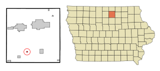
Kossuth County is a county in the U.S. state of Iowa. As of the 2020 census, the population was 14,828. The county seat is Algona.

<span class="mw-page-title-main">Grundy County, Iowa</span> County in Iowa, United States

Grundy County is a county located in the U.S. state of Iowa. At the 2020 census, the population was 12,329. The county seat is Grundy Center. The county is named for Felix Grundy, former U.S. Attorney General.

<span class="mw-page-title-main">Floyd County, Iowa</span> County in Iowa, United States

Floyd County is a county located in the U.S. state of Iowa. As of the 2020 census, the population was 15,627. The county seat is Charles City.

<span class="mw-page-title-main">Butler County, Iowa</span> County in Iowa, United States

Butler County is a county located in the U.S. state of Iowa. As of the 2020 census, the population was 14,334. Its county seat is Allison. The county was organized in 1854 and named for General William O. Butler.

<span class="mw-page-title-main">Moulton, Iowa</span> City in Iowa, United States

Moulton is a city in Appanoose County, Iowa, United States. The population was 607 at the time of the 2020 census.

<span class="mw-page-title-main">Swaledale, Iowa</span> City in Iowa, United States

Swaledale is a city in Cerro Gordo County, Iowa, United States. The population was 144 at the time of the 2020 census. It is part of the Mason City Micropolitan Statistical Area.

<span class="mw-page-title-main">Protivin, Iowa</span> City in Iowa, United States

Protivin is a city in Chickasaw and Howard counties in the U.S. state of Iowa. The population was 269 at the time of the 2020 census. Early settlers named the city after the Bohemian town of Protivín in what is now the south of the Czech Republic. The current mayor of Protivin is Michael Lensing.

<span class="mw-page-title-main">Chester, Iowa</span> City in Iowa, United States

Chester is a city in Howard County, Iowa, United States. The population was 139 in the 2020 census, a decrease of 7.9% from the 151 population in the 2000 census. Chester is located close to the state line from Minnesota.

<span class="mw-page-title-main">Cresco, Iowa</span> City in Iowa, United States

Cresco is a city in Howard County, Iowa, United States. The population was 3,888 in the 2020 census, a decline from 3,905 in 2000 census. It is the county seat of Howard County.

<span class="mw-page-title-main">Elma, Iowa</span> City in Iowa, United States

Elma is a city in Howard County, Iowa, United States. The population was 505 at the time of the 2020 census.

<span class="mw-page-title-main">Lime Springs, Iowa</span> City in Iowa, United States

Lime Springs is a city in Howard County, Iowa, United States. The population was 473 at the time of the 2020 census.

<span class="mw-page-title-main">Crawfordsville, Iowa</span> City in Iowa, United States

Crawfordsville is a city in Washington County, Iowa, United States. It is part of the Iowa City, Iowa Metropolitan Statistical Area. The population was 277 at the 2020 census.

<span class="mw-page-title-main">Ridgeway, Iowa</span> City in Iowa, United States

Ridgeway is a city in Winneshiek County, Iowa, United States. The population was 275 at the time of the 2020 census.

<span class="mw-page-title-main">Blaine, Wisconsin</span> Town in Wisconsin, United States

Blaine is a town in Burnett County in the U.S. state of Wisconsin. The population was 197 at the 2010 census. The unincorporated communities of Riverside and Woodland Corner are located in the town.

<span class="mw-page-title-main">Salem, Pierce County, Wisconsin</span> Town in Wisconsin, United States

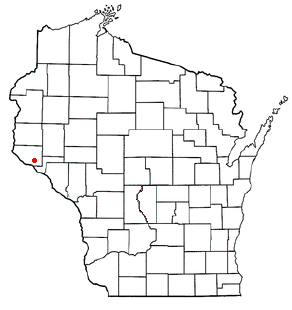
Salem is a town in Pierce County, Wisconsin, United States. The population was 475 at the 2020 census. The unincorporated community of Ono is also located partially in the town.

References

  1. 1 2 3 "2020 Census State Redistricting Data". census.gov. United states Census Bureau. Retrieved August 12, 2021.
  2. "Find a County". National Association of Counties. Archived from the original on May 31, 2011. Retrieved June 7, 2011.
  3. "Howard County, Iowa - History". Howard County, Iowa. Retrieved March 6, 2014.
  4. Gannett, Henry (1905). The Origin of Certain Place Names in the United States. Govt. Print. Off. p.  162.
  5. "US Gazetteer files: 2010, 2000, and 1990". United States Census Bureau. February 12, 2011. Retrieved April 23, 2011.
  6. "Annual Estimates of the Resident Population for Counties: April 1, 2020 to July 1, 2023". United States Census Bureau. Retrieved April 2, 2024.
  7. "U.S. Decennial Census". United States Census Bureau. Retrieved July 17, 2014.
  8. "Historical Census Browser". University of Virginia Library. Retrieved July 17, 2014.
  9. "Population of Counties by Decennial Census: 1900 to 1990". United States Census Bureau. Retrieved July 17, 2014.
  10. "Census 2000 PHC-T-4. Ranking Tables for Counties: 1990 and 2000" (PDF). United States Census Bureau. Retrieved July 17, 2014.
  11. "State & County QuickFacts". United States Census Bureau. Archived from the original on June 7, 2011. Retrieved July 17, 2014.
  12. "Population & Housing Occupancy Status 2010" (PDF). United States Census Bureau – American FactFinder. Retrieved August 15, 2022.
  13. "U.S. Census website". United States Census Bureau. Retrieved January 31, 2008.
  14. About the Society
  15. Leip, David. "Dave Leip's Atlas of U.S. Presidential Elections". uselectionatlas.org. Retrieved April 26, 2018.
  16. "2020 Iowa President Election Results". desmoinesregister.com. Retrieved February 3, 2021.

43°21′27″N92°18′56″W / 43.35750°N 92.31556°W / 43.35750; -92.31556