Pocahontas County | |
---|---|
Coordinates: 42°44′04″N94°40′39″W / 42.734444444444°N 94.6775°W | |
Country | United States |
State | Iowa |
Founded | 1851 |
Named for | Pocahontas |
Seat | Pocahontas |
Largest city | Pocahontas |
Area | |
• Total | 579 sq mi (1,500 km2) |
• Land | 577 sq mi (1,490 km2) |
• Water | 1.4 sq mi (4 km2) 0.2% |
Population (2020) | |
• Total | 7,078 |
• Density | 12/sq mi (4.7/km2) |
Time zone | UTC−6 (Central) |
• Summer (DST) | UTC−5 (CDT) |
Congressional district | 4th |
Website | pocahontascounty |
Pocahontas County is a county located in Iowa, United States. As of the 2020 census the population was 7,078, making it the state's ninth-least populous county. [1] The county seat is Pocahontas. [2] The county was formed in 1851. [3]
The county is named in honor of Pocahontas, the famous Native American woman from Jamestown, Virginia. A colossal statue of her stands in the city of Pocahontas. [3]
According to the U.S. Census Bureau, the county has a total area of 579 square miles (1,500 km2), of which 577 square miles (1,490 km2) is land and 1.4 square miles (3.6 km2) (0.2%) is water. [4]
Census | Pop. | Note | %± |
---|---|---|---|
1860 | 103 | — | |
1870 | 1,446 | 1,303.9% | |
1880 | 3,713 | 156.8% | |
1890 | 9,553 | 157.3% | |
1900 | 15,339 | 60.6% | |
1910 | 14,808 | −3.5% | |
1920 | 15,602 | 5.4% | |
1930 | 15,687 | 0.5% | |
1940 | 16,266 | 3.7% | |
1950 | 15,496 | −4.7% | |
1960 | 14,234 | −8.1% | |
1970 | 12,729 | −10.6% | |
1980 | 11,369 | −10.7% | |
1990 | 9,525 | −16.2% | |
2000 | 8,662 | −9.1% | |
2010 | 7,310 | −15.6% | |
2020 | 7,078 | −3.2% | |
2023 (est.) | 6,976 | [5] | −1.4% |
U.S. Decennial Census [6] 1790-1960 [7] 1900-1990 [8] 1990-2000 [9] 2010-2018 [10] |
The 2020 census recorded a population of 7,078 in the county, with a population density of 12.2213/sq mi (4.7187/km2). 95.79% of the population reported being of one race. There were 3,666 housing units, of which 3,090 were occupied. [1]
Race | Num. | Perc. |
---|---|---|
White (NH) | 6,383 | 90.2% |
Black or African American (NH) | 66 | 0.9% |
Native American (NH) | 10 | 0.14% |
Asian (NH) | 29 | 0.41% |
Pacific Islander (NH) | 23 | 0.32% |
Other/Mixed (NH) | 213 | 3% |
Hispanic or Latino | 354 | 5% |
The 2010 census recorded a population of 7,310 in the county, with a population density of 12.654/sq mi (4.886/km2). There were 3,794 housing units, of which 3,233 were occupied. [12]
As of the census [13] of 2000, there were 8,662 people, 3,617 households, and 2,430 families residing in the county. The population density was 15 people per square mile (5.8 people/km2). There were 3,988 housing units at an average density of 7 units per square mile (2.7 units/km2). The racial makeup of the county was 98.49% White, 0.24% Black or African American, 0.17% Native American, 0.17% Asian, 0.01% Pacific Islander, 0.30% from other races, and 0.61% from two or more races. 0.89% of the population were Hispanic or Latino of any race.
There were 3,617 households, out of which 29.50% had children under the age of 18 living with them, 58.30% were married couples living together, 5.90% had a female householder with no husband present, and 32.80% were non-families. 30.20% of all households were made up of individuals, and 17.80% had someone living alone who was 65 years of age or older. The average household size was 2.35 and the average family size was 2.91.
In the county, the population was spread out, with 25.40% under the age of 18, 5.30% from 18 to 24, 23.40% from 25 to 44, 24.10% from 45 to 64, and 21.70% who were 65 years of age or older. The median age was 42 years. For every 100 females there were 96.60 males. For every 100 females age 18 and over, there were 93.20 males.
The median income for a household in the county was $33,362, and the median income for a family was $40,568. Males had a median income of $27,929 versus $20,515 for females. The per capita income for the county was $17,006. About 6.60% of families and 9.10% of the population were below the poverty line, including 12.30% of those under age 18 and 6.50% of those age 65 or over.
The population ranking of the following table is based on the 2020 census of Pocahontas County. [1]
†county seat
Rank | City/Town/etc. | Municipal type | Population (2020 Census) |
---|---|---|---|
1 | † Pocahontas | City | 1,867 |
2 | Laurens | City | 1,264 |
3 | Fonda | City | 636 |
4 | Rolfe | City | 509 |
5 | Gilmore City (partially in Humboldt County ) | City | 217 (487 total) |
6 | Palmer | City | 138 |
7 | Havelock | City | 130 |
8 | Varina | City | 68 |
9 | Plover | City | 50 |
Between 1928 and 2004, Pocahontas County was a reliable bellwether county, backing the nationwide winner in every election except for 1960 (by only 37 votes) and 1988. The county has taken a rightward turn in the 21st century. After backing George W. Bush in 2000 and 2004, John McCain in 2008, and Mitt Romney in 2012 by sizable but not huge margins, Pocahontas County swung even further right in 2016. Donald Trump took nearly 70% of the vote share in the county and won the county by an astounding 45% margin. Trump further increased these numbers in 2020, winning almost 74% of the county's vote and increasing his margin of victory to just under 50%, both records for Pocahontas County for any candidate since the beginning of the 20th century.
Year | Republican | Democratic | Third party | |||
---|---|---|---|---|---|---|
No. | % | No. | % | No. | % | |
2020 | 2,826 | 73.92% | 933 | 24.40% | 64 | 1.67% |
2016 | 2,702 | 69.91% | 963 | 24.92% | 200 | 5.17% |
2012 | 2,396 | 59.42% | 1,523 | 37.77% | 113 | 2.80% |
2008 | 2,138 | 53.29% | 1,800 | 44.87% | 74 | 1.84% |
2004 | 2,441 | 56.60% | 1,822 | 42.24% | 50 | 1.16% |
2000 | 2,242 | 54.14% | 1,736 | 41.92% | 163 | 3.94% |
1996 | 1,707 | 40.50% | 1,981 | 47.00% | 527 | 12.50% |
1992 | 1,743 | 37.33% | 1,919 | 41.10% | 1,007 | 21.57% |
1988 | 1,871 | 40.22% | 2,722 | 58.51% | 59 | 1.27% |
1984 | 2,627 | 50.64% | 2,481 | 47.82% | 80 | 1.54% |
1980 | 3,194 | 56.17% | 1,959 | 34.45% | 533 | 9.37% |
1976 | 2,700 | 45.85% | 3,055 | 51.88% | 134 | 2.28% |
1972 | 3,138 | 57.19% | 2,241 | 40.84% | 108 | 1.97% |
1968 | 2,940 | 52.56% | 2,364 | 42.26% | 290 | 5.18% |
1964 | 2,079 | 34.24% | 3,988 | 65.68% | 5 | 0.08% |
1960 | 3,445 | 50.23% | 3,408 | 49.69% | 6 | 0.09% |
1956 | 3,606 | 52.89% | 3,201 | 46.95% | 11 | 0.16% |
1952 | 4,472 | 61.73% | 2,517 | 34.74% | 256 | 3.53% |
1948 | 2,397 | 39.61% | 3,500 | 57.84% | 154 | 2.55% |
1944 | 2,600 | 41.94% | 3,577 | 57.70% | 22 | 0.35% |
1940 | 2,985 | 41.92% | 4,118 | 57.83% | 18 | 0.25% |
1936 | 2,277 | 33.39% | 4,357 | 63.89% | 185 | 2.71% |
1932 | 1,800 | 28.48% | 4,245 | 67.16% | 276 | 4.37% |
1928 | 3,322 | 53.75% | 2,824 | 45.70% | 34 | 0.55% |
1924 | 2,537 | 39.65% | 819 | 12.80% | 3,042 | 47.55% |
1920 | 4,046 | 70.07% | 1,639 | 28.39% | 89 | 1.54% |
1916 | 1,808 | 51.29% | 1,658 | 47.04% | 59 | 1.67% |
1912 | 760 | 22.95% | 1,176 | 35.52% | 1,375 | 41.53% |
1908 | 1,857 | 57.42% | 1,315 | 40.66% | 62 | 1.92% |
1904 | 2,175 | 66.09% | 976 | 29.66% | 140 | 4.25% |
1900 | 2,176 | 61.84% | 1,287 | 36.57% | 56 | 1.59% |
1896 | 1,866 | 56.82% | 1,377 | 41.93% | 41 | 1.25% |
Shelby County is a county located in the U.S. state of Iowa. As of the 2020 census, the population was 11,746. The county seat is Harlan. Its name is in honor of Isaac Shelby, the first Governor of Kentucky.
Pocahontas County is a county located in the eastern part of the U.S. state of West Virginia. As of the 2020 census, the population was 7,869. Its county seat is Marlinton. The county was established in 1821. It is named after the daughter of the Powhatan chief of the Native Americans in the United States who came from Jamestown, Virginia. She married an English settler, and their children became ancestors of many of the First Families of Virginia.
Cass County is a county in the U.S. state of Nebraska. As of the 2020 United States Census, the population was 26,598. Its county seat and largest city is Plattsmouth. The county was formed in 1855, and was named for General Lewis Cass, an American military officer, politician, and statesman.
Webster County is a county in the U.S. state of Iowa. As of the 2020 census, the population was 36,999. The county seat is Fort Dodge. The county was established in January 1851, one of 43 counties established by a legislative package. This county was named after Daniel Webster, an American statesman noted for his moving oratory.
Taylor County is a county located in the U.S. state of Iowa. As of the 2020 census, the population was 5,896, making it the fourth-least populous county in Iowa. The county seat is Bedford. The county was formed in 1847 and named after General and President Zachary Taylor.
Palo Alto County is a county located in the U.S. state of Iowa. As of the 2020 census, the population was 8,996. The county seat is Emmetsburg. It is named after the Battle of Palo Alto, the first major battle of the Mexican–American War.
Page County is a county located in the U.S. state of Iowa. As of the 2020 census, the population was 15,211. The county seat is Clarinda. The county is named in honor of Captain John Page of the 4th U.S. Infantry, who was mortally wounded in the Battle of Palo Alto.
Marion County is a county in the U.S. state of Iowa. As of the 2020 census, the population was 33,414. The county seat is Knoxville. It is named for Francis Marion, a brigadier general from South Carolina in the American Revolutionary War.
Lucas County is a county located in the U.S. state of Iowa. As of the 2020 census, the population was 8,634. The county seat is Chariton. The county was formed in 1846 and was named for Robert Lucas, a Governor of the Territory.
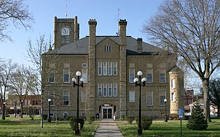
Keokuk County is a county located in the U.S. state of Iowa. As of the 2020 United States Census, the population was 10,033. The county seat is Sigourney.
Grundy County is a county located in the U.S. state of Iowa. At the 2020 census, the population was 12,329. The county seat is Grundy Center. The county is named for Felix Grundy, former U.S. Attorney General.
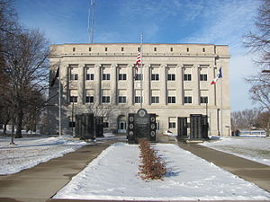
Emmet County is a county located in the U.S. state of Iowa. As of the 2020 census, the population was 9,388. The county seat is Estherville.
Clarke County is a county located in the U.S. state of Iowa. As of the 2020 census, the population was 9,748. The county seat is Osceola. The county was formed in January 1846, one of twelve counties established by legislative action in a comprehensive act. It was named for James Clarke, a Governor of the Iowa Territory.
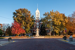
Carroll County is a county located in the U.S. state of Iowa. As of the 2020 census, the population was 20,760. Its county seat is Carroll. The county is named in honor of Charles Carroll of Carrollton, signer of the Declaration of Independence.
Pulaski is a city in Davis County, Iowa, United States. The population was 264 at the time of the 2020 census.
Coulter is a city in Franklin County, Iowa, United States. The population was 219 at the 2020 census.
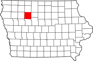
Pocahontas is a city in and the county seat of Pocahontas County, Iowa, United States. The population was 1,867 in the 2020 census, a decline from the 1,970 population in 2000.
Rolfe is a city in Pocahontas County, Iowa, United States. The population was 509 at the time of the 2020 census.
Varina is an incorporated small, rural village in Pocahontas County, Iowa, United States. The population was 68 at the time of the 2020 census.
Bevington is a city in Madison and Warren Counties in the U.S. state of Iowa. The population was 57 at the 2020 census. It is part of the Des Moines–West Des Moines Metropolitan Statistical Area.