Woodbury County, Iowa

Last updated

Woodbury County
Woodbury County Courthouse from NW 1.JPG
Woodbury County, Iowa Seal.png
Map of Iowa highlighting Woodbury County.svg
Location within the U.S. state of Iowa
Iowa in United States.svg
Iowa's location within the U.S.
Coordinates: 42°23′29″N96°03′03″W / 42.3914°N 96.0508°W / 42.3914; -96.0508
CountryFlag of the United States.svg United States
StateFlag of Iowa.svg  Iowa
Founded1851
Named for Levi Woodbury [1]
Seat Sioux City
Largest citySioux City
Area
  Total878 sq mi (2,270 km2)
  Land872.59 sq mi (2,260.0 km2)
  Water4.79 sq mi (12.4 km2)  0.55%
Population
 (2020)
  Total105,941
  Density120/sq mi (47/km2)
Time zone UTC−6 (Central)
  Summer (DST) UTC−5 (CDT)
Congressional district 4th
Website www.woodburycountyiowa.gov

Woodbury County is a county located in the U.S. state of Iowa. As of the 2020 census, the population was 105,941, [2] making it the sixth-most populous county in Iowa. The county seat is Sioux City. [3]

Contents

Woodbury County is included in the Sioux City metropolitan area. [4]

History

Originally established in 1851 as Wahkaw County, the Iowa Legislature in 1853 changed the name to Woodbury County in honor of Levi Woodbury (1789–1851), a senator and governor of New Hampshire who served as a Supreme Court justice from 1844 until his death.

The first county seat of Wahkaw County was the now-extinct village of Thompsonville; when the Legislature changed the county name to Woodbury, the new county seat became Sergeant's Bluff (now Sergeant Bluff). The county seat was moved to Sioux City in 1856.

The Winnebago Tribe of Nebraska (Ho-Chunk) owns reservation land in Woodbury County.

Geography

The county is on the western edge of Iowa, with its western border being the Missouri River.

According to the U.S. Census Bureau, the county has a total area of 878 square miles (2,270 km2), of which 873 square miles (2,260 km2) is land and 4.9 square miles (13 km2) (0.6%) is water. [5] It is the third-largest county by area in Iowa.

Major highways

Transit

Adjacent counties

Demographics

Historical population
CensusPop.Note
1860 1,119
1870 6,172451.6%
1880 14,996143.0%
1890 55,632271.0%
1900 54,610−1.8%
1910 67,61623.8%
1920 92,17136.3%
1930 101,66910.3%
1940 103,6271.9%
1950 103,9170.3%
1960 107,8493.8%
1970 103,052−4.4%
1980 100,884−2.1%
1990 98,276−2.6%
2000 103,8775.7%
2010 102,172−1.6%
2020 105,9413.7%
2023 (est.)105,951 [6] 0.0%
U.S. Decennial Census [7]
1790-1960 [8] 1900-1990 [9]
1990-2000 [10] 2010-2018 [11] [12] 2022 [11]
Population of Woodbury County from US census data WoodburyCountyIowaPop2020.png
Population of Woodbury County from US census data

2020 census

2022 US Census population pyramid for Woodbury County from ACS 5-year estimates WoodburyCountyIA2022PopPyr.png
2022 US Census population pyramid for Woodbury County from ACS 5-year estimates

The 2020 census recorded a population of 105,941 in the county, with a population density of

Woodbury County Racial Composition [13]
RaceNum.Perc.
White (NH)72,23768.2%
Black or African American (NH)5,0764.8%
Native American (NH)1,8931.8%
Asian (NH)2,9572.8%
Pacific Islander (NH)6510.61%
Other/Mixed (NH)4,3814.14%
Hispanic or Latino 18,74617.7%

2010 census

The 2010 census recorded a population of 102,172 in the county, with a population density of

2000 census

As of the census [15] of 2000, there were 103,877 people, 39,151 households, and 26,426 families residing in the county. The population density was 119 inhabitants per square mile (46/km2). There were 41,394 housing units at an average density of 47 per square mile (18/km2). The racial makeup of the county was 87.48% White, 2.02% Black or African American, 1.69% Native American, 2.41% Asian, 0.04% Pacific Islander, 4.37% from other races, and 1.99% from two or more races. 9.11% of the population were Hispanic or Latino of any race.

Of the 39,151 households, 34.00% had children under the age of 18 living with them, 51.90% were married couples living together, 11.30% had a female householder with no husband present, and 32.50% were non-families. 26.60% of households were one person and 11.20% were one person aged 65 or older. The average household size was 2.58 and the average family size was 3.13.

The age distribution was 27.30% under the age of 18, 10.20% from 18 to 24, 28.30% from 25 to 44, 20.80% from 45 to 64, and 13.40% 65 or older. The median age was 34 years. For every 100 females, there were 96.10 males. For every 100 females age 18 and over, there were 92.80 males.

The median household income was $38,509 and the median family income was $46,499. Males had a median income of $31,664 versus $22,599 for females. The per capita income for the county was $18,771. About 7.20% of families and 10.30% of the population were below the poverty line, including 13.60% of those under age 18 and 7.40% of those age 65 or over.

Politics

For much of the second half of the 20th century, Woodbury County tilted Republican, albeit not as overwhelmingly as most of western Iowa. Between 1988 and 2012 Woodbury County was the quintessential swing county in Iowa. No candidate won it by more than 3.5% over that quarter-century. This was the only county in Iowa that Barack Obama won in 2012 that he failed to carry in 2008. However, in 2016, Woodbury County swung over dramatically to Donald Trump, who carried it by a 19 percent margin, the largest margin of victory since Lyndon Johnson's landslide election in 1964.

United States presidential election results for Woodbury County, Iowa [16] [17]
Year Republican Democratic Third party
No.%No.%No.%
2020 25,73656.73%18,70441.23%9222.03%
2016 24,72756.56%16,21037.08%2,7816.36%
2012 21,84148.52%22,30249.54%8761.95%
2008 22,21949.58%21,98349.05%6131.37%
2004 22,45150.80%21,45548.55%2890.65%
2000 18,86449.78%17,69146.68%1,3413.54%
1996 16,36843.69%17,22445.97%3,87210.34%
1992 18,14842.34%17,39840.59%7,31817.07%
1988 18,79047.90%20,15351.38%2820.72%
1984 23,00254.31%18,95144.75%3970.94%
1980 23,55354.43%15,93036.81%3,7928.76%
1976 22,85352.79%19,66445.43%7701.78%
1972 23,75757.34%16,97440.97%6991.69%
1968 21,15950.62%18,28143.73%2,3635.65%
1964 17,34739.23%26,84160.70%300.07%
1960 26,83255.05%21,90644.94%60.01%
1956 25,39955.89%19,99744.00%490.11%
1952 27,51858.36%19,47441.30%1590.34%
1948 16,65542.61%22,05656.43%3730.95%
1944 18,54447.43%20,44852.30%1040.27%
1940 22,83248.19%24,45751.62%890.19%
1936 14,15732.92%26,84762.43%1,9984.65%
1932 12,76431.97%26,39766.12%7611.91%
1928 20,58754.78%16,83144.78%1660.44%
1924 16,63947.38%5,67616.16%12,80436.46%
1920 17,60362.07%9,81534.61%9443.33%
1916 5,73538.61%8,81959.38%2992.01%
1912 2,44118.66%4,56434.89%6,07746.45%
1908 6,58753.52%5,22242.43%4984.05%
1904 7,59766.85%2,80924.72%9588.43%
1900 7,04557.54%4,79639.17%4023.28%
1896 6,20454.86%4,87643.12%2292.02%
1892 4,62047.07%4,15642.34%1,04010.59%
1888 4,16952.87%3,58845.50%1291.64%
1884 2,78953.78%2,38045.89%170.33%
1880 1,45356.25%99538.52%1355.23%

Communities

Terraces, conservation tillage and buffers save soil and improve water quality on this Woodbury County farm in 1999. TerracesBuffers.JPG
Terraces, conservation tillage and buffers save soil and improve water quality on this Woodbury County farm in 1999.

Cities

Unincorporated communities

Townships

Population ranking

The population ranking of the following table is based on the 2020 census of Woodbury County. [2]

county seat

RankCity/Town/etc.Municipal typePopulation (2020 Census)
1 Sioux City (partially in Plymouth County )City85,791 (85,797 total)
2 Sergeant Bluff City5,015
3 Moville City1,687
4 Sloan City1,042
5 Lawton City943
6 Correctionville City766
7 Anthon City545
8 Pierson City337
9 Danbury City320
10 Salix City295
11 Bronson City294
12 Hornick City255
13 Cushing City230
14 Smithland City181
15 Climbing Hill CDP97
16 Oto City72

See also

Related Research Articles

<span class="mw-page-title-main">Union County, South Dakota</span> County in South Dakota, United States

Union County is the southernmost county in the U.S. state of South Dakota. As of the 2020 census, the population was 16,811, making it the 13th most populous county in South Dakota. Its county seat has been Elk Point since April 30, 1865. Originally named Cole County, its name was changed to Union on January 7, 1864, because of Civil War sentiment.

<span class="mw-page-title-main">Lincoln County, South Dakota</span> County in South Dakota, United States

Lincoln County is a county in the U.S. state of South Dakota. As of the 2020 census, the population was 65,161, making it the third most populous county in South Dakota. Its county seat is Canton. The county was named for Abraham Lincoln, 16th President of the United States.

<span class="mw-page-title-main">Cass County, Nebraska</span> County in Nebraska, United States

Cass County is a county in the U.S. state of Nebraska. As of the 2020 United States Census, the population was 26,598. Its county seat and largest city is Plattsmouth. The county was formed in 1855, and was named for General Lewis Cass, an American military officer, politician, and statesman.

<span class="mw-page-title-main">Sioux County, Iowa</span> County in Iowa, United States

Sioux County is a county located in the U.S. state of Iowa. As of the 2020 census, the population was 35,872. Its county seat is Orange City. Its largest city is Sioux Center.

<span class="mw-page-title-main">Pottawattamie County, Iowa</span> County in Iowa, United States

Pottawattamie County is a county located in the U.S. state of Iowa. At the 2020 census, the population was 93,667, making it the tenth-most populous county in Iowa. The county takes its name from the Potawatomi Native American tribe. The county seat is Council Bluffs.

<span class="mw-page-title-main">Plymouth County, Iowa</span> County in Iowa, United States

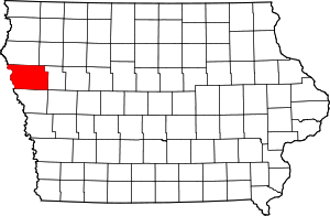
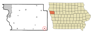
Plymouth County is a county located in the U.S. state of Iowa. As of the 2020 census, the population was 25,698. The county seat is Le Mars. Plymouth County was named after Plymouth, Massachusetts.

<span class="mw-page-title-main">Monroe County, Iowa</span> County in Iowa, United States

Monroe County is a county located in the south central part of the U.S. state of Iowa. In the early 20th century, it was a center of bituminous coal mining and in 1910 had a population of more than 25,000. As mining declined, people moved elsewhere for work. In the 2020 census, the population was 7,577. The county seat is Albia. The county, originally called Kishkekosh County after a famous chief of the Meskwaki, was renamed for James Monroe, fifth President of the United States.

<span class="mw-page-title-main">Monona County, Iowa</span> County in Iowa, United States

Monona County is a county located in the U.S. state of Iowa. As of the 2020 census, the population was 8,751. The county seat is Onawa.

<span class="mw-page-title-main">Lyon County, Iowa</span> County in Iowa, United States

Lyon County is the most northwesterly county of the U.S. state of Iowa. As of the 2020 census, the population was 11,934. The county seat is Rock Rapids.

<span class="mw-page-title-main">Ida County, Iowa</span> County in Iowa, United States

Ida County is a county located in the U.S. state of Iowa. As of the 2020 census the population was 7,005, making it the state's eighth-least populous county. The county seat is Ida Grove. The county was authorized by the Iowa Legislature in January 1851 as a packet of projected counties in unorganized territory of western Iowa. It was named after Ida Smith, the first child of European immigrants to be born in this region.

<span class="mw-page-title-main">Harrison County, Iowa</span> County in Iowa, United States

Harrison County is a county located in the U.S. state of Iowa. As of the 2020 census, the population was 14,582. The county seat is Logan. The county was formed in 1851. It was named for the ninth US President William Henry Harrison.

<span class="mw-page-title-main">Floyd County, Iowa</span> County in Iowa, United States

Floyd County is a county located in the U.S. state of Iowa. As of the 2020 census, the population was 15,627. The county seat is Charles City.

<span class="mw-page-title-main">Cherokee County, Iowa</span> County in Iowa, United States

Cherokee County is a county located in the U.S. state of Iowa. As of the 2020 census, the population was 11,658. The county seat is Cherokee. The county was formed on January 15, 1851, from open territory. It was named after the Cherokee people.

<span class="mw-page-title-main">Correctionville, Iowa</span> City in Iowa, United States

Correctionville is a city in Woodbury County, Iowa, United States. It is part of the Sioux City, IA–NE–SD Metropolitan Statistical Area. The population was 766 at the time of the 2020 census. The town name comes from the original survey of the town. Correctionville has been noted for its unusual place name. It is supposedly the longest single-word place name in the state of Iowa.

<span class="mw-page-title-main">Danbury, Iowa</span> City in Iowa, United States

Danbury is a city in Woodbury County, Iowa, United States. It is part of the Sioux City, IA–NE–SD Metropolitan Statistical Area. The population was 320 at the time of the 2020 census. Danbury has two churches, St. Mary's Catholic Church and the United Methodist Church. Danbury holds a fall celebration called Corn Days during harvest.

<span class="mw-page-title-main">Lawton, Iowa</span> City in Iowa, United States

Lawton is a city in Woodbury County, Iowa, Iowa, United States. It is part of the Sioux City metropolitan area. The population was 943 at the time of the 2020 census.

<span class="mw-page-title-main">Moville, Iowa</span> City in Iowa, United States

Moville is a city in Woodbury County, Iowa, United States. It is part of the Sioux City, IA–NE–SD Metropolitan Statistical Area. The population was 1,687 in the 2020 census, an increase from 1,583 in 2000.

<span class="mw-page-title-main">Sergeant Bluff, Iowa</span> City in Iowa, United States

Sergeant Bluff is a city in Woodbury County, Iowa, United States. It is part of the Sioux City, IA–NE–SD Metropolitan Statistical Area. The population was 5,015 at the time of the 2020 census.

<span class="mw-page-title-main">Smithland, Iowa</span> City in Iowa, United States

Smithland is a city in Woodbury County, Iowa, United States. It is part of the Sioux City, IA–NE–SD Metropolitan Statistical Area. The population was 181 at the time of the 2020 census.

<span class="mw-page-title-main">Sioux City metropolitan area</span> Metropolitan Statistical Area in the United States

The Sioux City metropolitan statistical area, as defined by the United States Census Bureau, is an area consisting of four counties in three states – Iowa, Nebraska, and South Dakota, anchored by the city of Sioux City, Iowa. As of the 2020 census, the MSA had a population of 145,940. Plymouth County, Iowa, was removed from the definition of the MSA prior to the 2020 census.

References

  1. Chicago and North Western Railway Company (1908). A History of the Origin of the Place Names Connected with the Chicago & North Western and Chicago, St. Paul, Minneapolis & Omaha Railways. p. 165.
  2. 1 2 3 "2020 Census State Redistricting Data". census.gov. United states Census Bureau. Retrieved August 12, 2021.
  3. "Find a County". National Association of Counties. Retrieved June 7, 2011.
  4. United States Office of Management and Budget. "Update of Statistical Area Definitions and Guidance on Their Uses" (PDF). pp. 5, 36. Archived from the original (PDF) on May 14, 2006. Retrieved July 21, 2006.
  5. "US Gazetteer files: 2010, 2000, and 1990". United States Census Bureau. February 12, 2011. Retrieved April 23, 2011.
  6. "Annual Estimates of the Resident Population for Counties: April 1, 2020 to July 1, 2023". United States Census Bureau. Retrieved April 2, 2024.
  7. "U.S. Decennial Census". United States Census Bureau. Retrieved July 20, 2014.
  8. "Historical Census Browser". University of Virginia Library. Retrieved July 20, 2014.
  9. "Population of Counties by Decennial Census: 1900 to 1990". United States Census Bureau. Retrieved July 20, 2014.
  10. "Census 2000 PHC-T-4. Ranking Tables for Counties: 1990 and 2000" (PDF). United States Census Bureau. Archived (PDF) from the original on March 27, 2010. Retrieved July 20, 2014.
  11. 1 2 "State & County QuickFacts". United States Census Bureau. Archived from the original on June 7, 2011. Retrieved July 20, 2014.
  12. "QuickFacts: Woodbury County, Iowa". www.census.gov. United States Census Bureau. July 1, 2022. Retrieved June 3, 2023.
  13. "P2 HISPANIC OR LATINO, AND NOT HISPANIC OR LATINO BY RACE – 2020: DEC Redistricting Data (PL 94-171) – Woodbury County, Iowa".
  14. "Population & Housing Occupancy Status 2010" (PDF). United States Census Bureau American FactFinder. Archived (PDF) from the original on October 16, 2020. Retrieved August 15, 2022.
  15. "U.S. Census website". United States Census Bureau. Retrieved January 31, 2008.
  16. Leip, David. "Dave Leip's Atlas of U.S. Presidential Elections". uselectionatlas.org. Retrieved April 28, 2018.
  17. "Our Campaigns - U.S. President" . Retrieved January 22, 2021.
  18. Owego - google maps

Further reading

42°23′29″N96°03′03″W / 42.39139°N 96.05083°W / 42.39139; -96.05083