Marion County | |
---|---|
Coordinates: 41°19′52″N93°06′08″W / 41.331111111111°N 93.102222222222°W | |
Country | United States |
State | Iowa |
Founded | 1845 |
Named for | Francis Marion |
Seat | Knoxville |
Largest city | Pella |
Area | |
• Total | 571 sq mi (1,480 km2) |
• Land | 555 sq mi (1,440 km2) |
• Water | 16 sq mi (40 km2) 2.8% |
Population (2020) | |
• Total | 33,414 |
• Density | 59/sq mi (23/km2) |
Time zone | UTC−6 (Central) |
• Summer (DST) | UTC−5 (CDT) |
Congressional district | 2nd |
Website | www |
Marion County is a county in the U.S. state of Iowa. As of the 2020 census, the population was 33,414. [1] The county seat is Knoxville. [2] It is named for Francis Marion, a brigadier general from South Carolina in the American Revolutionary War. [3]
According to the U.S. Census Bureau, the county has a total area of 571 square miles (1,480 km2), of which 555 square miles (1,440 km2) is land and 16 square miles (41 km2) (2.8%) is water. [4]
Census | Pop. | Note | %± |
---|---|---|---|
1850 | 5,482 | — | |
1860 | 16,813 | 206.7% | |
1870 | 24,436 | 45.3% | |
1880 | 25,111 | 2.8% | |
1890 | 23,058 | −8.2% | |
1900 | 24,159 | 4.8% | |
1910 | 22,995 | −4.8% | |
1920 | 24,957 | 8.5% | |
1930 | 25,727 | 3.1% | |
1940 | 27,019 | 5.0% | |
1950 | 25,930 | −4.0% | |
1960 | 25,886 | −0.2% | |
1970 | 26,352 | 1.8% | |
1980 | 29,669 | 12.6% | |
1990 | 30,001 | 1.1% | |
2000 | 32,052 | 6.8% | |
2010 | 33,309 | 3.9% | |
2020 | 33,414 | 0.3% | |
2023 (est.) | 33,770 | [5] | 1.1% |
U.S. Decennial Census [6] 1790-1960 [7] 1900-1990 [8] 1990-2000 [9] 2010-2018 [10] |
The 2020 census recorded a population of 33,414 in the county, with a population density of 58.4743/sq mi (22.5770/km2). 96.24% of the population reported being of one race. 91.15% were non-Hispanic White, 0.87% were Black, 2.09% were Hispanic, 0.21% were Native American, 1.20% were Asian, 0.06% were Native Hawaiian or Pacific Islander and 4.41% were some other race or more than one race. There were 14,073 housing units, of which 13,145 were occupied. [1]
The 2010 census recorded a population of 33,309 in the county, with a population density of 60.1018/sq mi (23.2054/km2). There were 13,914 housing units, of which 12,723 were occupied. [11]
As of the census [12] of 2000, there were 32,052 people, 12,017 households, and 8,532 families residing in the county. The population density was 58 people per square mile (22 people/km2). There were 12,755 housing units at an average density of 23 units per square mile (8.9 units/km2). The racial makeup of the county was 97.46% White, 0.42% Black or African American, 0.19% Native American, 1.03% Asian, 0.04% Pacific Islander, 0.22% from other races, and 0.64% from two or more races. 0.80% of the population were Hispanic or Latino of any race.
There were 12,017 households, out of which 33.00% had children under the age of 18 living with them, 61.20% were married couples living together, 6.90% had a female householder with no husband present, and 29.00% were non-families. 25.60% of all households were made up of individuals, and 11.90% had someone living alone who was 65 years of age or older. The average household size was 2.50 and the average family size was 3.02.
In the county, the population was spread out, with 25.30% under the age of 18, 10.20% from 18 to 24, 26.50% from 25 to 44, 22.10% from 45 to 64, and 15.90% who were 65 years of age or older. The median age was 37 years. For every 100 females there were 98.60 males. For every 100 females age 18 and over, there were 95.80 males.
The median income for a household in the county was $42,401, and the median income for a family was $50,052. Males had a median income of $36,460 versus $25,573 for females. The per capita income for the county was $18,717. About 5.20% of families and 7.60% of the population were below the poverty line, including 8.70% of those under age 18 and 10.80% of those age 65 or over.
The population ranking of the following table is based on the 2020 census of Marion County. [1]
†county seat
Rank | City/Town/etc. | Municipal type | Population (2020 Census) |
---|---|---|---|
1 | Pella | City | 10,464 |
2 | † Knoxville | City | 7,595 |
3 | Pleasantville | City | 1,676 |
4 | Melcher-Dallas | City | 1,195 |
5 | Bussey | City | 387 |
6 | Harvey | City | 236 |
7 | Hamilton | City | 119 |
8 | Swan | City | 76 |
9 | Marysville | City | 44 |
Year | Republican | Democratic | Third party | |||
---|---|---|---|---|---|---|
No. | % | No. | % | No. | % | |
2020 | 12,663 | 65.84% | 6,178 | 32.12% | 391 | 2.03% |
2016 | 10,962 | 61.53% | 5,482 | 30.77% | 1,372 | 7.70% |
2012 | 9,828 | 55.57% | 7,507 | 42.44% | 352 | 1.99% |
2008 | 9,256 | 54.34% | 7,421 | 43.57% | 355 | 2.08% |
2004 | 9,990 | 59.83% | 6,574 | 39.37% | 132 | 0.79% |
2000 | 8,358 | 58.01% | 5,741 | 39.85% | 309 | 2.14% |
1996 | 6,100 | 46.74% | 5,978 | 45.80% | 974 | 7.46% |
1992 | 6,062 | 44.79% | 5,531 | 40.87% | 1,940 | 14.34% |
1988 | 5,914 | 45.65% | 6,922 | 53.44% | 118 | 0.91% |
1984 | 7,259 | 53.24% | 6,313 | 46.30% | 62 | 0.45% |
1980 | 6,665 | 49.30% | 5,490 | 40.61% | 1,363 | 10.08% |
1976 | 5,429 | 45.79% | 6,226 | 52.51% | 202 | 1.70% |
1972 | 6,583 | 57.09% | 4,643 | 40.27% | 305 | 2.65% |
1968 | 5,791 | 52.35% | 4,618 | 41.75% | 653 | 5.90% |
1964 | 3,903 | 32.96% | 7,911 | 66.80% | 28 | 0.24% |
1960 | 7,444 | 61.99% | 4,547 | 37.87% | 17 | 0.14% |
1956 | 6,830 | 56.13% | 5,316 | 43.69% | 22 | 0.18% |
1952 | 7,165 | 57.25% | 5,196 | 41.51% | 155 | 1.24% |
1948 | 4,312 | 39.67% | 6,300 | 57.96% | 258 | 2.37% |
1944 | 4,874 | 42.99% | 6,365 | 56.14% | 99 | 0.87% |
1940 | 5,763 | 45.19% | 6,915 | 54.22% | 75 | 0.59% |
1936 | 4,975 | 41.51% | 6,745 | 56.27% | 266 | 2.22% |
1932 | 3,695 | 33.49% | 7,067 | 64.05% | 272 | 2.47% |
1928 | 6,225 | 59.36% | 4,113 | 39.22% | 149 | 1.42% |
1924 | 5,058 | 47.65% | 2,383 | 22.45% | 3,174 | 29.90% |
1920 | 5,435 | 56.62% | 3,861 | 40.22% | 303 | 3.16% |
1916 | 2,459 | 42.90% | 3,094 | 53.98% | 179 | 3.12% |
1912 | 1,191 | 22.66% | 2,276 | 43.31% | 1,788 | 34.02% |
1908 | 2,625 | 46.12% | 2,739 | 48.12% | 328 | 5.76% |
1904 | 2,988 | 53.05% | 2,202 | 39.10% | 442 | 7.85% |
1900 | 2,950 | 48.53% | 2,950 | 48.53% | 179 | 2.94% |
1896 | 2,741 | 46.05% | 3,119 | 52.40% | 92 | 1.55% |
1892 | 2,319 | 43.70% | 2,540 | 47.86% | 448 | 8.44% |
1888 | 2,374 | 47.30% | 2,322 | 46.26% | 323 | 6.44% |
1884 | 2,356 | 47.27% | 2,593 | 52.03% | 35 | 0.70% |
1880 | 2,452 | 47.46% | 1,520 | 29.42% | 1,194 | 23.11% |
Adams County is a county in the U.S. state of Iowa. As of the 2020 census, the population was 3,704, making it Iowa's least-populous county. Its county seat is Corning.
Clay County is a county located in the U.S. state of Iowa. As of the 2020 census, the population was 16,384. Its county seat is Spencer. Its name is in honor of Henry Clay Jr., a colonel who died in action in the Mexican–American War, and son of Henry Clay, famous American statesman from Kentucky.
Burt County is a county in the U.S. state of Nebraska, bordering the west bank of the upper Missouri River. As of the 2020 United States Census, the population was 6,722. Its county seat is Tekamah. The county was formed in 1854 and named after Francis Burt, the first governor of Nebraska Territory.
Warren County is a county located in the U.S. state of Iowa. As of the 2020 census, the population was 52,403. The county seat is Indianola.
Mitchell County is a county located in the U.S. state of Iowa. As of the 2020 census, the population was 10,565. The county seat is Osage. It is not clear whom the county is named after: the county website mentions John Mitchell, an early surveyor, and an Irish patriot John Mitchel.
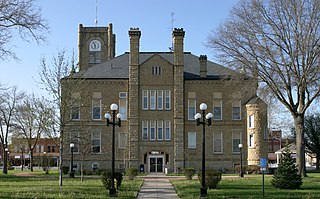
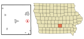
Mahaska County is a county located in the U.S. state of Iowa. As of the 2020 census, the population was 22,190. The county seat is Oskaloosa.
Lucas County is a county located in the U.S. state of Iowa. As of the 2020 census, the population was 8,634. The county seat is Chariton. The county was formed in 1846 and was named for Robert Lucas, a Governor of the Territory.
Linn County is a county located in the U.S. state of Iowa. As of the 2020 census, the population was 230,299, making it the second-most populous county in Iowa. The county seat is Cedar Rapids. Linn County is named in honor of Senator Lewis F. Linn of Missouri. Linn County is included in the Cedar Rapids, IA Metropolitan Statistical Area.
Kossuth County is a county in the U.S. state of Iowa. As of the 2020 census, the population was 14,828. The county seat is Algona.
Howard County is a county located in the US state of Iowa. As of the 2020 census, the population was 9,469. The county seat is Cresco. The county was founded in 1851; it was named for General Tilghman Ashurst Howard, a Representative of Indiana.
Harrison County is a county located in the U.S. state of Iowa. As of the 2020 census, the population was 14,582. The county seat is Logan. The county was formed in 1851. It was named for the ninth US President William Henry Harrison.
Hamilton County is a county located in the U.S. state of Iowa. As of the 2020 census, the population was 15,039. The county seat is Webster City. The county was named to honor William W. Hamilton, a President of the Iowa State Senate.
Franklin County is a county located in the U.S. state of Iowa. As of the 2020 census, the population was 10,019. The county seat is Hampton. The county was formed on January 15, 1851 and named after Benjamin Franklin.
Fayette County is a county located in the U.S. state of Iowa. As of the 2020 census, the population was 19,509. The county seat is West Union.
Clayton County is a county located in the U.S. state of Iowa. As of the 2020 census, the population was 17,043. Its county seat is Elkader. The county was established in 1837 and was named in honor of John M. Clayton, United States Senator from Delaware and later Secretary of State under President Zachary Taylor.
Cherokee County is a county located in the U.S. state of Iowa. As of the 2020 census, the population was 11,658. The county seat is Cherokee. The county was formed on January 15, 1851, from open territory. It was named after the Cherokee people.
Clarence is a city in Cedar County, Iowa, United States. The population was 1,039 at the time of the 2020 census.
Harvey is a city in Marion County, Iowa, United States. At the time of the 2020 census, its population was 236.
Pleasantville is a city in Marion County in Iowa, United States. The population was 1,676 at the time of the 2020 census. Pleasantville is most famous for being the corporate headquarters of Smokey Row Coffee and the hometown of softball player Chelsea Thomas whose honors include, three time All American at The University of Missouri, three time conference pitcher of the year, and United States National Team member.
Malvern is a city in Mills County, Iowa, United States. The population was 1,046 at the time of the 2020 census. The Wabash Trace—a railroad converted to a bicycle trail—passes through Malvern. The Mills County Fair is held here, although Glenwood is the county seat. Malvern is the largest town in the eastern half of the county.