Clarke County, Iowa

Last updated

Clarke County
Clarke County, Iowa Courthouse.jpg
Map of Iowa highlighting Clarke County.svg
Location within the U.S. state of Iowa
Iowa in United States.svg
Iowa's location within the U.S.
Coordinates: 41°01′22″N93°47′11″W / 41.022777777778°N 93.786388888889°W / 41.022777777778; -93.786388888889
CountryFlag of the United States.svg United States
StateFlag of Iowa.svg  Iowa
FoundedJanuary 13, 1846
Named for James Clarke
Seat Osceola
Largest cityOsceola
Area
  Total432 sq mi (1,120 km2)
  Land431 sq mi (1,120 km2)
  Water0.6 sq mi (2 km2)  0.1%
Population
 (2020)
  Total9,748
  Density23/sq mi (8.7/km2)
Time zone UTC−6 (Central)
  Summer (DST) UTC−5 (CDT)
Congressional district 2nd
Website clarkecounty.iowa.gov

Clarke County is a county located in the U.S. state of Iowa. As of the 2020 census, the population was 9,748. [1] The county seat is Osceola. [2] The county was formed in January 1846, one of twelve counties established by legislative action in a comprehensive act. [3] [4] It was named for James Clarke, a Governor of the Iowa Territory. [5]

Contents

History

The first courthouse for Clarke County was a wood frame two–story structure in Osceola. In 1883 it was replaced with a brick structure on former park area in the town square. By the 1950s this building was insufficient, and the present modern structure was completed in 1956. It was added to the National Register of Historic Places in 2018. [6]

Geography

According to the US Census Bureau, the county has a total area of 432 square miles (1,120 km2), of which 431 square miles (1,120 km2) is land and 0.6 square miles (1.6 km2) (0.1%) is water. [7]

Adjacent counties

Highways

Transit

Communities

Cities

Unincorporated communities

Townships

Demographics

Historical population
CensusPop.Note
1850 79
1860 5,4276,769.6%
1870 8,73561.0%
1880 11,51331.8%
1890 11,332−1.6%
1900 12,4409.8%
1910 10,736−13.7%
1920 10,506−2.1%
1930 10,384−1.2%
1940 10,233−1.5%
1950 9,369−8.4%
1960 8,222−12.2%
1970 7,581−7.8%
1980 8,61213.6%
1990 8,287−3.8%
2000 9,13310.2%
2010 9,2861.7%
2020 9,7485.0%
2023 (est.)9,588 [9] −1.6%
U.S. Decennial Census [10]
1790-1960 [11] 1900-1990 [12]
1990-2000 [13] 2010-2018 [14]
Population of Clarke County from US census data ClarkeCountyIowaPop2020.png
Population of Clarke County from US census data

2020 census

2022 US Census population pyramid for Clarke County from ACS 5-year estimates ClarkeCountyIA2022PopPyr.png
2022 US Census population pyramid for Clarke County from ACS 5-year estimates

The 2020 census recorded a population of 9,748 in the county, with a population density of

Clarke County Racial Composition [15]
RaceNum.Perc.
White (NH)7,83780.4%
Black or African American (NH)430.4%
Native American (NH)70.07%
Asian (NH)810.83%
Pacific Islander (NH)400.41%
Other/Mixed (NH)2062.11%
Hispanic or Latino 1,53415.73%

2010 census

The 2010 census recorded a population of 9,286 in the county, with a population density of

2000 census

As of the census [17] of 2000, there were 9,133 people, 3,584 households, and 2,498 families residing in the county. The population density was 21 people per square mile (8.1 people/km2). There were 3,934 housing units at an average density of 9 units per square mile (3.5 units/km2). The racial makeup of the county was 96.64% White, 0.11% Black or African American, 0.33% Native American, 0.35% Asian, 0.03% Pacific Islander, 1.96% from other races, and 0.58% from two or more races. 4.04% of the population were Hispanic or Latino of any race.

There were 3,584 households, out of which 32.10% had children under the age of 18 living with them, 57.80% were married couples living together, 8.30% had a female householder with no husband present, and 30.30% were non-families. 25.90% of all households were made up of individuals, and 13.30% had someone living alone who was 65 years of age or older. The average household size was 2.50 and the average family size was 3.01.

In the county, the population was spread out, with 26.30% under the age of 18, 7.60% from 18 to 24, 26.50% from 25 to 44, 22.50% from 45 to 64, and 17.10% who were 65 years of age or older. The median age was 39 years. For every 100 females there were 97.00 males. For every 100 females age 18 and over, there were 94.00 males.

The median income for a household in the county was $34,474, and the median income for a family was $42,171. Males had a median income of $29,648 versus $20,522 for females. The per capita income for the county was $16,409. About 6.20% of families and 8.50% of the population were below the poverty line, including 12.10% of those under age 18 and 7.70% of those age 65 or over.

Population ranking

The population ranking of the following table is based on the 2020 census of Clarke County. [1]

county seat

RankCity/Town/etc.Municipal typePopulation (2020 Census)
1 Osceola City5,415
2 Murray City684
3 Woodburn City146
4 Weldon (mostly in Decatur County )City136

Politics

Prior to 1988, Clarke County was a Republican-leaning swing county, only failing to back the national winner four times between 1896 & 1984. The county was reliably Democratic from 1988 to 2012, but made a 29.5 point swing to back Donald Trump in 2016. [18]

United States presidential election results for Clarke County, Iowa [19]
Year Republican Democratic Third party
No.%No.%No.%
2020 3,14467.32%1,46631.39%601.28%
2016 2,71360.91%1,46532.89%2766.20%
2012 2,12447.95%2,18949.41%1172.64%
2008 2,11847.65%2,21849.90%1092.45%
2004 2,20048.18%2,32350.88%430.94%
2000 1,98447.51%2,08149.83%1112.66%
1996 1,40135.71%2,05352.33%46911.96%
1992 1,41733.26%1,92145.09%92221.64%
1988 1,63141.46%2,26257.50%411.04%
1984 2,26252.35%2,03046.98%290.67%
1980 2,41754.88%1,61436.65%3738.47%
1976 1,73741.87%2,33356.23%791.90%
1972 2,21456.75%1,59040.76%972.49%
1968 2,05951.48%1,65541.38%2867.15%
1964 1,54636.70%2,65963.13%70.17%
1960 2,63157.82%1,90641.89%130.29%
1956 2,46255.99%1,92943.87%60.14%
1952 3,21565.69%1,65333.78%260.53%
1948 2,19550.13%2,10147.98%831.90%
1944 2,60356.78%1,94642.45%350.76%
1940 2,96253.76%2,51345.61%350.64%
1936 2,57148.85%2,61349.65%791.50%
1932 1,60839.90%2,34258.11%801.99%
1928 2,78061.92%1,64236.57%681.51%
1924 2,55452.48%74315.27%1,57032.26%
1920 3,15070.79%1,25728.25%430.97%
1916 1,50755.10%1,17542.96%531.94%
1912 88235.44%91036.56%69728.00%
1908 1,62458.00%1,13440.50%421.50%
1904 1,79964.57%89632.16%913.27%
1900 1,80056.69%1,32241.64%531.67%
1896 1,64651.53%1,51747.50%310.97%

See also

Related Research Articles

<span class="mw-page-title-main">Osceola County, Michigan</span> County in Michigan, United States

Osceola County is a county in the U.S. state of Michigan. As of the 2020 United States Census, the population was 22,891. The county seat is Reed City.

<span class="mw-page-title-main">Osceola County, Iowa</span> County in Iowa, United States

Osceola County is a county located in the U.S. state of Iowa. As of the 2020 census the population was 6,192, making it the state's fifth-least populous county. It is named for Seminole war chief Osceola. The county seat is Sibley, named for H. H. Sibley of Minnesota.

<span class="mw-page-title-main">Lucas County, Iowa</span> County in Iowa, United States

Lucas County is a county located in the U.S. state of Iowa. As of the 2020 census, the population was 8,634. The county seat is Chariton. The county was formed in 1846 and was named for Robert Lucas, a Governor of the Territory.

<span class="mw-page-title-main">Franklin County, Iowa</span> County in Iowa, United States

Franklin County is a county located in the U.S. state of Iowa. As of the 2020 census, the population was 10,019. The county seat is Hampton. The county was formed on January 15, 1851 and named after Benjamin Franklin.

<span class="mw-page-title-main">Dickinson County, Iowa</span> County in Iowa, United States

Dickinson County is a county located in the U.S. state of Iowa. As of the 2020 census, the population was 17,703. The county seat is Spirit Lake. The county was organized in 1857 and is named in honor of Daniel S. Dickinson, a U.S. Senator for New York.

<span class="mw-page-title-main">Cypress Gardens, Florida</span> Census-designated place in Florida, United States

Cypress Gardens is a census-designated place (CDP) in Polk County, Florida, United States. The population was 10,169 at the 2020 census. It is part of the Lakeland–Winter Haven Metropolitan Statistical Area.

<span class="mw-page-title-main">Osceola, Iowa</span> City in Iowa, United States

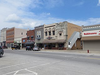
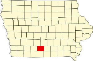
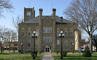
Osceola is a city in Clarke County, Iowa, United States. The population was 5,160 at the time of the 2020 census. It is the county seat of Clarke County.

<span class="mw-page-title-main">Weldon, Iowa</span> City in Iowa, United States

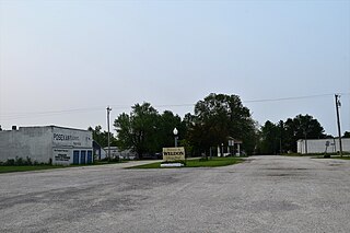
Weldon is a city in Clarke and Decatur counties of the U.S. state of Iowa. The population was 136 at the time of the 2020 census.

<span class="mw-page-title-main">Reasnor, Iowa</span> City in Iowa, United States

Reasnor is a city in Jasper County, Iowa, United States. The population was 152 at the time of the 2020 census.

<span class="mw-page-title-main">Calumet, Iowa</span> City in Iowa, United States

Calumet is a city in O'Brien County, Iowa, United States. The population was 146 at the 2020 census.

<span class="mw-page-title-main">Paullina, Iowa</span> City in Iowa, United States

Paullina is a city in O'Brien County, Iowa, United States. The population was 982 at the 2020 census.

<span class="mw-page-title-main">Ashton, Iowa</span> City in Iowa, United States

Ashton is a city in Osceola County, Iowa, United States. The population was 436 at the 2020 census.

<span class="mw-page-title-main">Harris, Iowa</span> City in Iowa, United States

Harris is a city in Osceola County, Iowa, United States. The population was 151 at the time of the 2020 census.

<span class="mw-page-title-main">Melvin, Iowa</span> City in Iowa, United States

Melvin is a city in Osceola County, Iowa, United States. The population was 199 at the time of the 2020 census.

<span class="mw-page-title-main">Saylorville, Iowa</span> CDP in Iowa, United States

Saylorville is a census-designated place (CDP) in Polk County, Iowa, United States. The population was 3,584 at the 2020 census. It is part of the Des Moines–West Des Moines Metropolitan Statistical Area. The Saydel Community School District is located in this area, as is the unincorporated community of Marquisville.

<span class="mw-page-title-main">Manorville, Pennsylvania</span> Borough in Pennsylvania, United States

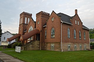
Manorville is a borough in Armstrong County, Pennsylvania, United States. The population was 382 at the 2020 census.

<span class="mw-page-title-main">Marion Township, Beaver County, Pennsylvania</span> Township in Pennsylvania, United States

Marion Township is a township that is located in Beaver County, Pennsylvania, United States. The population was 800 at the time of the 2020 census.

<span class="mw-page-title-main">Wilson, Eau Claire County, Wisconsin</span> Town in Wisconsin, United States

Wilson is a town in Eau Claire County, Wisconsin, United States. The population was 485 at the 2010 census. The unincorporated community of Wilson is located in the town.

<span class="mw-page-title-main">Bevington, Iowa</span> City in Iowa, United States

Bevington is a city in Madison and Warren Counties in the U.S. state of Iowa. The population was 57 at the 2020 census. It is part of the Des Moines–West Des Moines Metropolitan Statistical Area.

<span class="mw-page-title-main">Belmont, Wisconsin</span> Village in Wisconsin, United States

Belmont is a village in Lafayette County, Wisconsin, United States. The population was 986 at the 2010 census.

References

  1. 1 2 3 "2020 Census State Redistricting Data". census.gov. United states Census Bureau. Retrieved August 12, 2021.
  2. "Find a County". National Association of Counties. Archived from the original on May 31, 2011. Retrieved June 7, 2011.
  3. Pratt, LeRoy G. (1977). The Counties and Courthouses of Iowa. Mason City, Iowa: Klipto Printing and Office Supply Co.
  4. The other Iowa counties established on January 13, 1843, are Boone, Dallas, Decatur, Jasper, Lucas, Madison, Marshall, Polk, Story, Warren, and Wayne.
  5. Joan Callison & Jack Cantwell Callison (1932–1994); Curtis Burdell Burgus (1926–2018) & Nora Lee Burgus (née Kepple; 1927–1998); Darrell Carson & Beverly Carson; John Henderson & Janice Henderson, eds. (1968). "Clarke County". Celebrating Our 100th Year – Murray, Iowa; 1868–1968. p. 3 (digital image 3 of 78). Retrieved April 17, 2024 via Iowa Gen Web.{{cite book}}: CS1 maint: multiple names: editors list (link) CS1 maint: numeric names: editors list (link) Lock-green.svg .
  6. "Downtown Osceola added to National Register of Historic Places". Osceola Sentinel-Tribune. Osceola. February 15, 2018. Retrieved August 15, 2018.
  7. "US Gazetteer files: 2010, 2000, and 1990". US Census Bureau. February 12, 2011. Retrieved April 23, 2011.
  8. Clarke County IA Google Maps (accessed August 15, 2018)
  9. "Annual Estimates of the Resident Population for Counties: April 1, 2020 to July 1, 2023". United States Census Bureau. Retrieved April 2, 2024.
  10. "U.S. Decennial Census". United States Census Bureau. Retrieved August 1, 2013.
  11. "Historical Census Browser". University of Virginia Library. Archived from the original on August 11, 2012. Retrieved July 20, 2014.
  12. "Population of Counties by Decennial Census: 1900 to 1990". United States Census Bureau. Retrieved July 20, 2014.
  13. "Census 2000 PHC-T-4. Ranking Tables for Counties: 1990 and 2000" (PDF). United States Census Bureau. Archived (PDF) from the original on March 27, 2010. Retrieved July 20, 2014.
  14. "State & County QuickFacts". United States Census Bureau. Archived from the original on June 7, 2011. Retrieved July 14, 2014.
  15. "P2 HISPANIC OR LATINO, AND NOT HISPANIC OR LATINO BY RACE – 2020: DEC Redistricting Data (PL 94-171) – Clarke County, Iowa".
  16. "Population and Housing Occupancy Status: 2010 - State County". US Census Bureau – American FactFinder. Retrieved March 9, 2011.[ dead link ]
  17. "U.S. Census website". US Census Bureau. Retrieved January 31, 2008.
  18. "Here's a map of the US counties that flipped to Trump from Democrats". www.cnbc.com. Retrieved September 7, 2019.
  19. Leip, David. "Dave Leip's Atlas of U.S. Presidential Elections". uselectionatlas.org. Retrieved April 25, 2018.

41°01′22″N93°47′11″W / 41.02278°N 93.78639°W / 41.02278; -93.78639