Montgomery County, Iowa

Last updated

Montgomery County
Montgomery County Courthouse, Red Oak.jpg
Montgomery County Courthouse
Map of Iowa highlighting Montgomery County.svg
Location within the U.S. state of Iowa
Iowa in United States.svg
Iowa's location within the U.S.
Coordinates: 41°01′45″N95°09′05″W / 41.029166666667°N 95.151388888889°W / 41.029166666667; -95.151388888889
CountryFlag of the United States.svg United States
StateFlag of Iowa.svg  Iowa
Founded1851
Named for Richard Montgomery
Seat Red Oak
Largest cityRed Oak
Area
  Total425 sq mi (1,100 km2)
  Land424 sq mi (1,100 km2)
  Water0.9 sq mi (2 km2)  0.2%
Population
 (2020)
  Total10,330
  Density24/sq mi (9.4/km2)
Time zone UTC−6 (Central)
  Summer (DST) UTC−5 (CDT)
Congressional district 3rd
Website montgomerycountyia.gov

Montgomery County is a county located in the southwestern area of the U.S. state of Iowa. As of the 2020 census, the population was 10,330. [1] Its population has declined since a peak in 1900, since urbanization and decline of family farms. The county seat is Red Oak. [2] The county was founded by European-American migrants from eastern areas in 1851. [3] It was named in honor of Richard Montgomery, an American Revolutionary War general killed in 1775 while trying to capture Quebec City, Canada.

Contents

The county has been largely rural and devoted to agriculture. The county was first surveyed in 1852. It is famous as the location of the unsolved Villisca axe murders committed in 1912. Clyde Cessna, the founder of the Cessna Aircraft Company was born here.

Geography

According to the U.S. Census Bureau, the county has a total area of 425 square miles (1,100 km2), of which 424 square miles (1,100 km2) is land and 0.9 square miles (2.3 km2) (0.2%) is water. [4]

Major highways

Adjacent counties

Demographics

Historical population
CensusPop.Note
1860 1,256
1870 5,934372.5%
1880 15,895167.9%
1890 15,848−0.3%
1900 17,80312.3%
1910 16,604−6.7%
1920 17,0482.7%
1930 16,752−1.7%
1940 15,697−6.3%
1950 15,685−0.1%
1960 14,467−7.8%
1970 12,781−11.7%
1980 13,4134.9%
1990 12,076−10.0%
2000 11,771−2.5%
2010 10,740−8.8%
2020 10,330−3.8%
2023 (est.)10,139 [5] −1.8%
U.S. Decennial Census [6]
1790-1960 [7] 1900-1990 [8]
1990-2000 [9] 2010-2018 [10]
Population of Montgomery County from US census data MontgomeryCountyIowaPop2020.png
Population of Montgomery County from US census data

2020 census

2022 US Census population pyramid for Montgomery County from ACS 5-year estimates MontgomeryCountyIA2022PopPyr.png
2022 US Census population pyramid for Montgomery County from ACS 5-year estimates

The 2020 census recorded a population of 10,330 in the county, with a population density of

2010 census

The 2010 census recorded a population of 10,740 in the county, with a population density of

2000 census

At the 2000 census there were 11,771 people, 4,886 households, and 3,258 families in the county. The population density was 28 people per square mile (11 people/km2). There were 5,399 housing units at an average density of 13 per square mile (5.0/km2). The racial makeup of the county was 98.20% White, 0.08% Black or African American, 0.35% Native American, 0.25% Asian, 0.01% Pacific Islander, 0.68% from other races, and 0.44% from two or more races. 1.30%. [12] were Hispanic or Latino of any race.

Of the 4,886 households 29.70% had children under the age of 18 living with them, 54.40% were married couples living together, 8.70% had a female householder with no husband present, and 33.30% were non-families. 29.50% of households were one person and 14.70% were one person aged 65 or older. The average household size was 2.36 and the average family size was 2.91.

The age distribution was 25.00% under the age of 18, 6.50% from 18 to 24, 25.50% from 25 to 44, 22.80% from 45 to 64, and 20.30% 65 or older. The median age was 40 years. For every 100 females there were 90.20 males. For every 100 females age 18 and over, there were 87.30 males.

The median household income was $33,214 and the median family income was $40,129. Males had a median income of $28,531 versus $20,835 for females. The per capita income for the county was $16,373. About 6.50% of families and 9.10% of the population were below the poverty line, including 12.30% of those under age 18 and 6.00% of those age 65 or over.

Montgomery County Courthouse, Henry C. Koch, architect, 1891 Montgomery County, Iowa.jpg
Montgomery County Courthouse, Henry C. Koch, architect, 1891

Communities

Cities

Unincorporated community

Former towns

Townships

Population ranking

The population ranking of the following table is based on the 2020 census of Montgomery County. [1]

county seat

RankCity/Town/etc.Municipal typePopulation (2020 Census)
1 Red Oak City5,596
2 Villisca City1,132
3 Stanton City678
4 Elliott City338
5 Grant City86
6 Coburg City26

Politics

United States presidential election results for Montgomery County, Iowa [13]
Year Republican Democratic Third party
No.%No.%No.%
2020 3,65968.69%1,58329.72%851.60%
2016 3,43668.12%1,31426.05%2945.83%
2012 3,00159.72%1,92238.25%1022.03%
2008 2,88754.58%2,32643.98%761.44%
2004 3,60164.81%1,89934.18%561.01%
2000 3,41763.35%1,83834.07%1392.58%
1996 2,58349.69%1,91236.78%70313.52%
1992 2,40444.78%1,59929.78%1,36625.44%
1988 3,16662.08%1,89837.22%360.71%
1984 4,22471.23%1,66128.01%450.76%
1980 4,11567.97%1,55625.70%3836.33%
1976 3,67361.48%2,22937.31%721.21%
1972 4,39172.69%1,55925.81%911.51%
1968 4,15564.11%1,89229.19%4346.70%
1964 3,10146.98%3,48952.86%110.17%
1960 4,97465.19%2,65534.80%10.01%
1956 5,02765.77%2,59733.98%190.25%
1952 6,07472.88%2,23526.82%250.30%
1948 4,08459.10%2,75139.81%751.09%
1944 4,16561.40%2,57237.92%460.68%
1940 4,84858.98%3,33240.54%400.49%
1936 4,39552.43%3,92046.77%670.80%
1932 3,50747.39%3,76050.80%1341.81%
1928 5,15570.81%2,07928.56%460.63%
1924 4,61764.51%80511.25%1,73524.24%
1920 4,98076.50%1,40421.57%1261.94%
1916 2,33360.33%1,43137.01%1032.66%
1912 91723.07%1,20630.35%1,85146.58%
1908 2,55364.44%1,28232.36%1273.21%
1904 2,95675.25%72218.38%2506.36%
1900 2,92765.25%1,46732.70%922.05%
1896 2,92763.67%1,63435.54%360.78%

See also

Related Research Articles

<span class="mw-page-title-main">Adams County, Iowa</span> County in Iowa, United States

Adams County is a county in the U.S. state of Iowa. As of the 2020 census, the population was 3,704, making it Iowa's least-populous county. Its county seat is Corning.

<span class="mw-page-title-main">Montgomery County, Illinois</span> County in Illinois, United States

Montgomery County is a county located in the U.S. state of Illinois. According to the 2020 census, it had a population of 28,288. Its county seat is Hillsboro.

<span class="mw-page-title-main">Shelby County, Iowa</span> County in Iowa, United States

Shelby County is a county located in the U.S. state of Iowa. As of the 2020 census, the population was 11,746. The county seat is Harlan. Its name is in honor of Isaac Shelby, the first Governor of Kentucky.

<span class="mw-page-title-main">Taylor County, Iowa</span> County in Iowa, United States

Taylor County is a county located in the U.S. state of Iowa. As of the 2020 census, the population was 5,896, making it the fourth-least populous county in Iowa. The county seat is Bedford. The county was formed in 1847 and named after General and President Zachary Taylor.

<span class="mw-page-title-main">Guthrie County, Iowa</span> County in Iowa, United States

Guthrie County is a county located in the U.S. state of Iowa. As of the 2020 census, the population was 10,623. The county seat is Guthrie Center. The county was formed on January 15, 1851, and named after Captain Edwin B. Guthrie, who died in the Mexican–American War.

<span class="mw-page-title-main">Grundy County, Iowa</span> County in Iowa, United States

Grundy County is a county located in the U.S. state of Iowa. At the 2020 census, the population was 12,329. The county seat is Grundy Center. The county is named for Felix Grundy, former U.S. Attorney General.

<span class="mw-page-title-main">Nodaway, Iowa</span> City in Iowa, United States

Nodaway is a city in Nodaway Township, Adams County, Iowa, United States. The population was 74 at the time of the 2020 census. Nodaway was incorporated in 1900.

<span class="mw-page-title-main">Villisca, Iowa</span> City in Iowa, United States

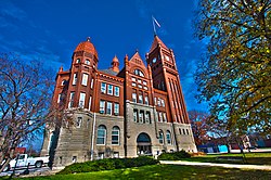
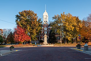
Villisca is a city in Montgomery County, Iowa, United States. The population was 1,132 at the time of the 2020 census. It is most notable for the unsolved axe mass murder that took place in the town during the summer of 1912.

<span class="mw-page-title-main">Huron Township, Michigan</span> Civil township in Michigan, United States

Huron Township is a civil township of Huron County in the U.S. state of Michigan. The population was 423 at the 2000 census.

Maple Grove Township is a civil township of Manistee County in the U.S. state of Michigan. The population was 1,342 at the 2020 census. The township is home to the village of Kaleva.

Lee Township is a township in Beltrami County, Minnesota, United States. The population was 36 as of the 2000 census.

<span class="mw-page-title-main">Echelon, New Jersey</span> Populated place in Camden County, New Jersey, US

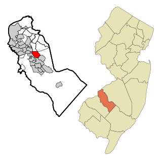
Echelon is an unincorporated community and census-designated place (CDP) located within Voorhees Township in Camden County, in the U.S. state of New Jersey. As of the 2010 United States Census, the CDP's population was 10,743.

<span class="mw-page-title-main">Frankfort Springs, Pennsylvania</span> Borough in Pennsylvania, United States

Frankfort Springs is a borough in southern Beaver County, Pennsylvania, United States. The population was 116 at the 2020 census. It is a part of the Pittsburgh metropolitan area.

<span class="mw-page-title-main">Douglass Township, Berks County, Pennsylvania</span> Township in Pennsylvania, United States

Douglass Township is a township in Berks County, Pennsylvania, United States. The population was 3,664 at the 2020 census.

<span class="mw-page-title-main">North Coventry Township, Pennsylvania</span> Township in Pennsylvania, United States

North Coventry Township is a township in Chester County, Pennsylvania, United States. The population was 7,866 at the 2010 census.

<span class="mw-page-title-main">Lawrence Park Township, Erie County, Pennsylvania</span> 1st Class Township in Pennsylvania, United States

Lawrence Park Township is the only first class township in Erie County, Pennsylvania, United States. The population was 3,821 at the 2020 census, down from 4,048 at the 2000 census. The 2010 census counted a population of 3,982, for a decline of 1.6% during the decade. The entire township is also listed as a census-designated place.

<span class="mw-page-title-main">Pine Grove Township, Schuylkill County, Pennsylvania</span> Township in Pennsylvania, United States

Pine Grove Township is a township that is located in Schuylkill County, Pennsylvania, United States. The population was 4,024 at the time of the 2020 census.

<span class="mw-page-title-main">Jackson Township, York County, Pennsylvania</span> Township in Pennsylvania, United States

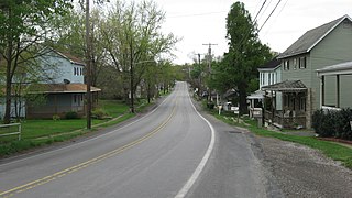
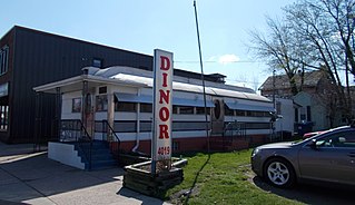
Jackson Township is a township in York County, Pennsylvania, United States. The population was 8,737 at the 2020 census. It was founded in 1853 from parts of Paradise Township. Jackson Township education is served by the Spring Grove Area School District. Police coverage is provided by Northern York County Regional Police Department, and EMS is provided by Spring Grove Area Ambulance. The township is home to York Airport.

<span class="mw-page-title-main">Barnes City, Iowa</span> City in Iowa, United States

Barnes City is a city in Mahaska and Poweshiek counties in the U.S. state of Iowa. The population was 156 at the 2020 census.

<span class="mw-page-title-main">Cave Township, Franklin County, Illinois</span> Township in Illinois, United States

Cave Township is one of twelve townships in Franklin County, Illinois, USA. As of the 2020 census, its population was 1,683 and it contained 828 housing units.

References

  1. 1 2 3 "2020 Census State Redistricting Data". census.gov. United states Census Bureau. Retrieved August 12, 2021.
  2. "Find a County". National Association of Counties. Retrieved June 7, 2011.
  3. William Walace Merritt (1906). A History of the County of Montgomery. The Express Publishing Company. montgomery county iowa founding.
  4. "US Gazetteer files: 2010, 2000, and 1990". United States Census Bureau. February 12, 2011. Retrieved April 23, 2011.
  5. "Annual Estimates of the Resident Population for Counties: April 1, 2020 to July 1, 2023". United States Census Bureau. Retrieved April 2, 2024.
  6. "U.S. Decennial Census". United States Census Bureau. Retrieved July 20, 2014.
  7. "Historical Census Browser". University of Virginia Library. Retrieved July 20, 2014.
  8. "Population of Counties by Decennial Census: 1900 to 1990". United States Census Bureau. Retrieved July 20, 2014.
  9. "Census 2000 PHC-T-4. Ranking Tables for Counties: 1990 and 2000" (PDF). United States Census Bureau. Retrieved July 20, 2014.
  10. "State & County QuickFacts". United States Census Bureau. Archived from the original on June 7, 2011. Retrieved July 20, 2014.
  11. "Population & Housing Occupancy Status 2010" (PDF). United States Census Bureau American FactFinder. Retrieved August 15, 2022.
  12. "U.S. Census website". United States Census Bureau . Retrieved January 31, 2008.
  13. Leip, David. "Dave Leip's Atlas of U.S. Presidential Elections". uselectionatlas.org. Retrieved April 27, 2018.

41°01′45″N95°09′05″W / 41.02917°N 95.15139°W / 41.02917; -95.15139