Jackson County, Iowa

Last updated

Jackson County
Jackson County Courthouse - Maquoketa, Iowa.JPG
Jackson County Courthouse
Map of Iowa highlighting Jackson County.svg
Location within the U.S. state of Iowa
Iowa in United States.svg
Iowa's location within the U.S.
Coordinates: 42°10′13″N90°34′30″W / 42.170277777778°N 90.575°W / 42.170277777778; -90.575
CountryFlag of the United States.svg United States
StateFlag of Iowa.svg  Iowa
FoundedDecember 21, 1837
Named for Andrew Jackson
Seat Maquoketa
Largest cityMaquoketa
Area
  Total650 sq mi (1,700 km2)
  Land584 sq mi (1,510 km2)
  Water69 sq mi (180 km2)  10.63%
Population
 (2020)
  Total19,485
  Density30/sq mi (12/km2)
Time zone UTC−6 (Central)
  Summer (DST) UTC−5 (CDT)
Congressional district 1st
Website jacksoncounty.iowa.gov

Jackson County is a county located in the U.S. state of Iowa. As of the 2020 census, the population was 19,485. [1] The county seat is Maquoketa. [2]

Contents

History

The county was formed on December 21, 1837, and named after US President Andrew Jackson. [3]

In the early morning of July 22, 2022, an assailant killed three members of a family at the campground of Maquoketa Caves State Park, located in the county. The assailant, identified as 23-year-old Anthony Sherwin of Nebraska, later committed suicide. [4]

Geography

According to the U.S. Census Bureau, the county has a total area of 650 square miles (1,700 km2), of which 636 square miles (1,650 km2) is land and 14 square miles (36 km2) (2.1%) is water. [5] Its eastern border is formed by the Mississippi River.

Major highways

Adjacent counties

National protected areas

State protected areas

Demographics

Historical population
CensusPop.Note
1840 1,411
1850 7,210411.0%
1860 18,493156.5%
1870 22,61922.3%
1880 23,7715.1%
1890 22,771−4.2%
1900 23,6153.7%
1910 21,258−10.0%
1920 19,931−6.2%
1930 18,481−7.3%
1940 19,1813.8%
1950 18,622−2.9%
1960 20,75411.4%
1970 20,8390.4%
1980 22,5038.0%
1990 19,950−11.3%
2000 20,2961.7%
2010 19,848−2.2%
2020 19,485−1.8%
2023 (est.)19,342 [6] −0.7%
U.S. Decennial Census [7]
1790-1960 [8] 1900-1990 [9]
1990-2000 [10] 2010-2018 [11]
Population of Jackson County from US census data JacksonCountyIowaPop2020.png
Population of Jackson County from US census data

2020 census

2022 US Census population pyramid for Jackson County from ACS 5-year estimates JacksonCountyIA2022PopPyr.png
2022 US Census population pyramid for Jackson County from ACS 5-year estimates

The 2020 census recorded a population of 19,485 in the county, with a population density of

2010 census

The 2010 census recorded a population of 19,848 in the county, with a population density of

2000 census

As of the census [13] of 2000, there were 20,296 people, 8,078 households, and 5,589 families residing in the county. The population density was 32 people per square mile (12 people/km2). There were 8,949 housing units at an average density of 14 units per square mile (5.4 units/km2). The racial makeup of the county was 98.96% White, 0.10% Black or African American, 0.12% Native American, 0.09% Asian, 0.11% Pacific Islander, 0.15% from other races, and 0.47% from two or more races. 0.60% of the population were Hispanic or Latino of any race.

There were 8,078 households, out of which 32.00% had children under the age of 18 living with them, 58.20% were married couples living together, 7.70% had a female householder with no husband present, and 30.80% were non-families. 27.00% of all households were made up of individuals, and 13.80% had someone living alone who was 65 years of age or older. The average household size was 2.47 and the average family size was 3.01.

In the county, the population was spread out, with 26.00% under the age of 18, 7.00% from 18 to 24, 26.50% from 25 to 44, 23.20% from 45 to 64, and 17.30% who were 65 years of age or older. The median age was 39 years. For every 100 females there were 97.10 males. For every 100 females age 18 and over, there were 93.90 males.

The median income for a household in the county was $34,529, and the median income for a family was $42,526. Males had a median income of $29,334 versus $20,577 for females. The per capita income for the county was $17,329. About 7.70% of families and 10.30% of the population were below the poverty line, including 13.90% of those under age 18 and 8.90% of those age 65 or over.

Government

As of 2018 the three-member Jackson County Board of Supervisors is Larry McDevitt, Mike Steines, and Jack Willey. Their Executive Assistant is LuAnn Goeke. [14]

Sheriff's office

The Jackson County Sheriff's Office is the primary law enforcement agency located in the county. The headquarters for the Sheriff's Department are in Maquoketa, Iowa. The department is led by an elected Sheriff. The current Sheriff is Brent Kilburg. [15]

Fire Protection and Emergency Medical Services

Fire protection in the county is left up to the discretion of the cities within the county. The towns of Maquoketa, Preston, Miles, Springbrook, Sabula, Baldwin, Bellevue, Andrew and La Motte all have their own fire departments providing protection for the whole county. Most city fire departments also provide rescue services. Fire equipment usually consists of Engines, Tankers and brush trucks as well as most fire departments owning a Rescue truck. The Maquoketa Fire department also owns a Ladder truck. Most firefighters certify as Iowa Firefighter One and HAZMAT Operations and some also are certified as EMTs. The towns of Maquoketa, Preston, Sabula and Bellevue also have their own Ambulance Services which provide coverage for the county while towns not having ambulances have First Responder units and contract ambulance response to a nearby community. All firefighters in Jackson County are volunteers and most EMS personnel are also volunteers however the Maquoketa Ambulance Service is a paid service. All Jackson County departments are members of the Jackson County Firefighters Association and the Iowa Firefighters Association. Mutual Aid Agreements from surrounding Iowa counties as well as the state of Illinois are in place to provide additional help during emergencies which tax the county emergency resources beyond their limits.

Townships

Jackson County is divided into 18 townships, administrative subdivisions of the county:

Hospital

Jackson County has one Hospital in Maquoketa, the Jackson County Regional Health Center. As of 2016 the hospital is under the administration of Genesis Healthcare. Patients near Maquoketa are transported to this hospital, while patients closer to Clinton County will most likely be taken to Mercy Medical Center in Clinton, Iowa. Some patients closer to Dubuque County are taken to Mercy or Finley Hospitals, both in the city of Dubuque.

Election results

Prior to 1988, Jackson County was a Republican-leaning swing county, only failing to back the national winner six times between 1880 & 1984. The county was reliably Democratic from 1988 to 2012, but swung by 18% to back Donald Trump in 2016. In 2020 Donald Trump carried Jackson County with 62% of the vote over Joseph Biden's 36%. [16] [17]

United States presidential election results for Jackson County, Iowa [18]
Year Republican Democratic Third party
No.%No.%No.%
2020 6,94062.33%4,02936.18%1661.49%
2016 5,82456.49%3,83737.22%6496.29%
2012 4,17740.78%5,90757.67%1581.54%
2008 3,67336.89%6,10261.28%1821.83%
2004 4,24242.37%5,65656.50%1131.13%
2000 3,76941.73%4,94554.75%3183.52%
1996 2,82733.41%4,60954.47%1,02512.11%
1992 2,67328.73%4,42147.51%2,21123.76%
1988 3,23739.32%4,86459.08%1321.60%
1984 4,81151.51%4,40047.11%1291.38%
1980 4,47951.17%3,51840.19%7578.65%
1976 4,22147.50%4,46750.27%1982.23%
1972 4,97555.75%3,70441.51%2452.75%
1968 4,53553.02%3,41339.90%6057.07%
1964 3,06637.37%5,13062.52%90.11%
1960 5,08453.89%4,34546.06%50.05%
1956 5,57562.61%3,18135.72%1491.67%
1952 5,86764.28%3,07433.68%1862.04%
1948 3,59751.35%3,26346.58%1452.07%
1944 4,34155.05%3,53744.85%80.10%
1940 5,41756.07%4,21843.66%260.27%
1936 3,58140.59%4,88955.41%3534.00%
1932 2,89234.03%5,09459.94%5136.04%
1928 4,74055.73%3,72943.84%370.43%
1924 4,21850.20%2,35227.99%1,83321.81%
1920 4,76367.99%1,95427.89%2884.11%
1916 2,53352.63%2,18645.42%941.95%
1912 1,17424.46%2,25947.06%1,36728.48%
1908 2,54248.51%2,54548.57%1532.92%
1904 2,89952.33%2,48344.82%1582.85%
1900 2,96450.66%2,85448.78%330.56%
1896 3,71352.49%3,27946.35%821.16%

Communities

Incorporated communities

List of Cities in Jackson County ranked by population
Recorded by the United States Census Bureau
'county seat'
RankCity2020 City Population2010 City PopulationChange
1 Maquoketa 6,1286,141−0.21%
2 Bellevue 2,3632,191+7.85%
3 Preston 9491,012−6.23%
4 Sabula 506576−12.15%
5 Miles 408445−8.31%
6 Andrew 380434−12.44%
7 La Motte 237260−8.85%
8 Monmouth 129153−15.69%
9 Springbrook 143144−0.69%
10 St. Donatus 120135−11.11%
11 Baldwin 99109−9.17%
12 Zwingle (partially in Dubuque County )8491−7.69%
13 Spragueville 9281+13.58%

Unincorporated communities

Former communities

  • Alma
  • Amoy
  • America
  • Bridgeport
  • Brookfield
  • Buckhorn
  • Canton
  • Carrollport
  • Centerville
  • Charleston
  • Charkstown
  • Cobb
  • Coloma
  • Copper Creek
  • Cottonville
  • Crabb
  • Crabb's Mill
  • Crabbtown
  • Deventersville
  • Duggan
  • Duke
  • Fremont
  • Fulton
  • Gordon's Ferry
  • Hickory Grove
  • Higginsport
  • Hugo
  • Hurstville
  • Fairfield
  • Farmers Creek
  • Franklin
  • Iron Hill
  • East Iron Hills
  • Isabel
  • Lowell
  • Millrock
  • Mount Algor
  • Nashville
  • New Castle
  • New Rochester
  • North Maquoketa
  • Otter Creek
  • Ozark
  • Pass
  • Prairie Springs
  • Rolley
  • Silsbee
  • Smiths Ferry
  • Springfield
  • Spruce Mills
  • Sterling
  • Sullivan
  • Summer Hill
  • Sylva
  • Tetes des Morts
  • Union Center
  • Van Buren
  • Wagonersburgh
  • Waterford
  • Wickliffe [19]

See also

Bibliography

Related Research Articles

<span class="mw-page-title-main">Tate County, Mississippi</span> County in Mississippi, United States

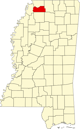
Tate County is a county located in the northwestern portion of the U.S. state of Mississippi. As of the 2020 census, the population was 28,064. Its county seat is Senatobia. Organized in 1873 during the Reconstruction era, from portions of DeSoto, Marshall, and Tunica counties, the county is named for Thomas Simpson Tate, one of the first prominent American settlers of the area.

<span class="mw-page-title-main">Washington County, Iowa</span> County in Iowa, United States

Washington County is a county located in the U.S. state of Iowa. As of the 2020 census, the population was 22,565. The county seat is Washington.

<span class="mw-page-title-main">Lucas County, Iowa</span> County in Iowa, United States

Lucas County is a county located in the U.S. state of Iowa. As of the 2020 census, the population was 8,634. The county seat is Chariton. The county was formed in 1846 and was named for Robert Lucas, a Governor of the Territory.

<span class="mw-page-title-main">Keokuk County, Iowa</span> County in Iowa, United States

Keokuk County is a county located in the U.S. state of Iowa. As of the 2020 United States Census, the population was 10,033. The county seat is Sigourney.

<span class="mw-page-title-main">Jones County, Iowa</span> County in Iowa, United States

Jones County is a county in the U.S. state of Iowa. As of the 2020 census the population was 20,646. The county seat is Anamosa. The county was founded in 1837 and named after George Wallace Jones, a United States senator and member of Congress.

<span class="mw-page-title-main">Dubuque County, Iowa</span> County in Iowa, United States

Dubuque County is a county located in the U.S. state of Iowa. As of the 2020 census, the population was 99,266, making it the eighth-most populous county in Iowa. The county seat is Dubuque. The county is named for Julien Dubuque, the first European settler of Iowa.

<span class="mw-page-title-main">Des Moines County, Iowa</span> County in Iowa, United States

Des Moines County is located in the U.S. state of Iowa. As of the 2020 census, the population was 38,910. The county seat and largest city is Burlington. It is one of Iowa's two original counties along with Dubuque County; both were organized by the Michigan Territorial legislature in 1834.

<span class="mw-page-title-main">Earlville, Iowa</span> City in Iowa, United States

Earlville is a city in Delaware County, Iowa, United States. The population was 716 at the time of the 2020 census.

<span class="mw-page-title-main">Cascade, Iowa</span> City in Iowa, United States

Cascade is a city in Dubuque and Jones counties, Iowa, United States. The Dubuque County portion is part of Dubuque Metropolitan Statistical Area, while the Jones County section is part of Cedar Rapids Metropolitan Statistical Area. The population was 2,386 at the 2020 census, up from 1,958 in 2000. The city is located within southwestern of Dubuque County and north-central Jones County.

<span class="mw-page-title-main">Andrew, Iowa</span> City in Iowa, United States

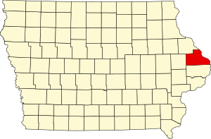
Andrew is a town in central Jackson County, Iowa, United States. The population was 380 at the 2020 census.

<span class="mw-page-title-main">Baldwin, Iowa</span> City in Iowa, United States

Baldwin is a city in Jackson County, Iowa, United States. The population was 99 at the 2020 census.

<span class="mw-page-title-main">Bellevue, Iowa</span> City in Iowa, United States

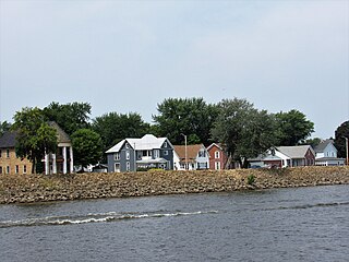
Bellevue is a city in eastern Jackson County, Iowa, United States. The city lies along the Mississippi River and next to Bellevue State Park. In 2020 its population was 2,363; up from a count of 2,191 at the 2010 Census, making it the second-largest and only growing city in Jackson County.

<span class="mw-page-title-main">Maquoketa, Iowa</span> City in Iowa, United States

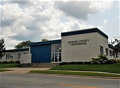
Maquoketa is a city in Jackson County, Iowa, United States. Located on the Maquoketa River, it is the county seat of Jackson County.

<span class="mw-page-title-main">Sabula, Iowa</span> City in Iowa, United States

Sabula is a city in Jackson County, Iowa, United States. The population was 506 at the 2020 census. Sabula is the site of Iowa's only island city. The island has a beach and a campground, as well as a harbor with boat docks and storage sheds to store boats during the winter. Sabula is the northern terminus of U.S. Route 67, a 1,560 mile (2,511 km) long north–south highway in the Central United States. The southern terminus of the route is at the United States–Mexico border in Presidio, Texas.

<span class="mw-page-title-main">Springbrook, Iowa</span> City in Iowa, United States

Springbrook is a small city in central Jackson County, Iowa, United States. The population was 143 at the time of the 2020 census.

<span class="mw-page-title-main">St. Donatus, Iowa</span> City in Iowa, United States

St. Donatus is a city in Jackson County, Iowa, United States. The population was 120 at the time of the 2020 census. St. Donatus is known for its status as a Luxembourger village, with historic architecture and views along U.S. Route 52. It is the home of a historic Catholic church, which is dedicated to Saint Donatus of Muenstereifel, the town's namesake. It was formerly named Tete Des Morts, which is the name of a creek that flows through the village.

<span class="mw-page-title-main">Zwingle, Iowa</span> City in Iowa, United States

Zwingle is a city in Dubuque and Jackson counties in the U.S. state of Iowa. The population was 84 at the time of the 2020 census, down from 100 in 2000.

<span class="mw-page-title-main">Iowa Highway 62</span> State highway in Iowa, United States

Iowa Highway 62 (Iowa 62) is a 19-mile-long (31 km) state highway in eastern Iowa. The highway begins in Maquoketa at Iowa 64, goes through Andrew, and ends in Bellevue at U.S. Highway 52 a few yards (meters) from the Mississippi River. The route has been on the primary highway system since the network was created in 1920. The road was graveled in the late 1920s and paved some 30 years later. It is called the Ansel Briggs Highway in honor of the first governor of Iowa who lived in Andrew during his term in office.

The Dubuque area is the general area encompassing Dubuque, Iowa. The official population of the Dubuque metro was 92,384 as of the 2005 population estimates. Although, if the unofficial counties are included, the area's population is near 190,000.

Jackson County, Iowa, is patrolled by several different agencies. The primary law enforcement agency for the county is the Jackson County Sheriff's Department; there are two other agencies that operate continuously, the other two being the Maquoketa Police Department and the Bellevue Police Department, and several more limited agencies. Ansel Briggs, the first governor of the state of Iowa, was at one time a Jackson County Sheriff.

References

  1. 1 2 "2020 Census State Redistricting Data". census.gov. United states Census Bureau. Retrieved August 11, 2020.
  2. "Find a County". National Association of Counties. Archived from the original on May 31, 2011. Retrieved June 7, 2011.
  3. Gannett, Henry (1905). The Origin of Certain Place Names in the United States. Govt. Print. Off. pp.  167.
  4. "Police: Gunman kills 3 at Iowa state park; shooter also dead". AP NEWS. July 22, 2022. Retrieved July 22, 2022.
  5. "US Gazetteer files: 2010, 2000, and 1990". United States Census Bureau. February 12, 2011. Retrieved April 23, 2011.
  6. "Annual Estimates of the Resident Population for Counties: April 1, 2020 to July 1, 2023". United States Census Bureau. Retrieved April 2, 2024.
  7. "U.S. Decennial Census". United States Census Bureau. Retrieved July 18, 2014.
  8. "Historical Census Browser". University of Virginia Library. Retrieved July 18, 2014.
  9. "Population of Counties by Decennial Census: 1900 to 1990". United States Census Bureau. Retrieved July 18, 2014.
  10. "Census 2000 PHC-T-4. Ranking Tables for Counties: 1990 and 2000" (PDF). United States Census Bureau. Archived (PDF) from the original on March 27, 2010. Retrieved July 18, 2014.
  11. "State & County QuickFacts". United States Census Bureau. Archived from the original on June 7, 2011. Retrieved July 18, 2014.
  12. "Population & Housing Occupancy Status 2010" (PDF). United States Census Bureau American FactFinder. Archived (PDF) from the original on October 16, 2020. Retrieved August 15, 2022.
  13. "U.S. Census website". United States Census Bureau . Retrieved January 31, 2008.
  14. Board of Supervisors. Retrieved September 23, 2018
  15. "Jackson County Iowa Sheriffs Office".
  16. "Here's a map of the US counties that flipped to Trump from Democrats". www.cnbc.com. Retrieved September 7, 2019.
  17. "Election Canvass Summary" (PDF). Iowa Secretary of State. November 30, 2020. p. 8. Retrieved January 25, 2021.
  18. Leip, David. "Dave Leip's Atlas of U.S. Presidential Elections". uselectionatlas.org. Retrieved April 26, 2018.
  19. "Iowa Ghost Towns - Jackson County". iowaghosttowns.com. Archived from the original on August 21, 2006. Retrieved October 22, 2023.

42°10′13″N90°34′30″W / 42.17028°N 90.57500°W / 42.17028; -90.57500