Wapello County, Iowa

Last updated

Wapello County
Wapello County, Iowa Courthouse.jpg
The courthouse in Ottumwa
Map of Iowa highlighting Wapello County.svg
Location within the U.S. state of Iowa
Iowa in United States.svg
Iowa's location within the U.S.
Coordinates: 41°01′46″N92°24′32″W / 41.029444444444°N 92.408888888889°W / 41.029444444444; -92.408888888889
CountryFlag of the United States.svg United States
StateFlag of Iowa.svg  Iowa
Founded1843
Named for Wapello
Seat Ottumwa
Largest cityOttumwa
Area
  Total436 sq mi (1,130 km2)
  Land432 sq mi (1,120 km2)
  Water4.2 sq mi (11 km2)  1.0%
Population
 (2020)
  Total35,437
  Density81/sq mi (31/km2)
Time zone UTC−6 (Central)
  Summer (DST) UTC−5 (CDT)
Congressional district 2nd
Website www.wapellocounty.org
Chief Wapello; "Wa-pel-la the Prince, Musquakee Chief", from History of the Indian Tribes of North America. Wapella.jpg
Chief Wapello; "Wa-pel-la the Prince, Musquakee Chief", from History of the Indian Tribes of North America.

Wapello County is a county located in the U.S. state of Iowa. As of the 2020 census, the population was 35,437. [1] The county seat is Ottumwa. [2] The county was formed on February 17, 1843, and named for Wapello, a Meskwaki chief. [3]

Contents

Wapello County is included in the Ottumwa, IA Micropolitan Statistical Area.

Geography

According to the U.S. Census Bureau, the county has a total area of 436 square miles (1,130 km2), of which 432 square miles (1,120 km2) is land and 4.2 square miles (11 km2) (1.0%) is water. [4]

Major highways

Transit

Adjacent counties

Demographics

Historical population
CensusPop.Note
1850 8,471
1860 14,51871.4%
1870 22,34653.9%
1880 25,28513.2%
1890 30,42620.3%
1900 35,42616.4%
1910 37,7436.5%
1920 37,9370.5%
1930 40,4806.7%
1940 44,2809.4%
1950 47,3977.0%
1960 46,126−2.7%
1970 42,149−8.6%
1980 40,241−4.5%
1990 35,696−11.3%
2000 36,0511.0%
2010 35,625−1.2%
2020 35,437−0.5%
2023 (est.)35,166 [5] −0.8%
U.S. Decennial Census [6]
1790-1960 [7] 1900-1990 [8]
1990-2000 [9] 2010-2018 [10]
Population of Wapello County from US census data WapelloCountyIowaPop2020.png
Population of Wapello County from US census data

2020 census

2022 US Census population pyramid for Wapello County from ACS 5-year estimates WapelloCountyIA2022PopPyr.png
2022 US Census population pyramid for Wapello County from ACS 5-year estimates

The 2020 census recorded a population of 35,437 in the county, with a population density of

Wapello County Racial Composition [11]
RaceNum.Perc.
White (NH)27,29577.02%
Black or African American (NH)1,4434.1%
Native American (NH)660.2%
Asian (NH)6221.8%
Pacific Islander (NH)5181.5%
Other/Mixed (NH)1,1613.3%
Hispanic or Latino 4,33212.22%

2010 census

The 2010 census recorded a population of 35,625 in the county, with a population density of

2000 census

As of the census [13] of 2000, there were 36,051 people, 14,784 households, and 9,801 families residing in the county. The population density was 84 people per square mile (32 people/km2). There were 15,873 housing units at an average density of 37 units per square mile (14 units/km2). The racial makeup of the county was 96.28% White, 0.93% Black or African American, 0.28% Native American, 0.65% Asian, 0.02% Pacific Islander, 1.05% from other races, and 0.79% from two or more races. 2.22% of the population were Hispanic or Latino of any race.

There were 14,784 households, out of which 28.80% had children under the age of 18 living with them, 52.70% were married couples living together, 9.90% had a female householder with no husband present, and 33.70% were non-families. 28.20% of all households were made up of individuals, and 13.40% had someone living alone who was 65 years of age or older. The average household size was 2.37 and the average family size was 2.89.

In the county, the population was spread out, with 23.30% under the age of 18, 9.70% from 18 to 24, 26.00% from 25 to 44, 23.30% from 45 to 64, and 17.80% who were 65 years of age or older. The median age was 39 years. For every 100 females there were 94.80 males. For every 100 females age 18 and over, there were 91.70 males.

The median income for a household in the county was $32,188, and the median income for a family was $39,224. Males had a median income of $31,346 versus $21,286 for females. The per capita income for the county was $16,500. About 9.40% of families and 13.20% of the population were below the poverty line, including 18.00% of those under age 18 and 7.90% of those age 65 or over.

Communities

Cities

Unincorporated communities

Townships

Population ranking

The population ranking of the following table is based on the 2020 census of Wapello County. [1]

county seat

RankCity/Town/etc.Municipal typePopulation (2020 Census)
1 Ottumwa City25,529
2 Eddyville (partially in Mahaska and Monroe Counties )City970
3 Eldon City783
4 Agency City620
5 Blakesburg City274
6 Kirkville City157
7 Chillicothe City76

Politics

Between 1864 and 1928, Wapello County backed the Republican candidate in every election except 1912, when former Republican Theodore Roosevelt ran as the Progressive candidate, fracturing the Republican party and allowing Democrat Woodrow Wilson to take the county with a plurality of the vote of less than 37%. From 1932 to 2012, the county voted Democratic in every election except two, the nationwide Republican landslides of Dwight D. Eisenhower in 1952 and Richard Nixon in 1972. Beginning in 2016, Wapello County has shifted back to the Republican column, as Donald Trump carried the county in both 2016 and 2020, winning by a margin of over 20% in 2016 and over 23% in 2020. Also in 2020, Trump became the first candidate from any party to obtain at least 60% of the county's vote since Michael Dukakis in 1988, and the first Republican to do so since Herbert Hoover in 1928.

United States presidential election results for Wapello County, Iowa [14]
Year Republican Democratic Third party
No.%No.%No.%
2020 9,51660.87%5,82137.24%2961.89%
2016 8,71557.53%5,59436.93%8405.54%
2012 6,78943.05%8,66354.93%3182.02%
2008 6,66341.80%8,82055.33%4572.87%
2004 7,40344.31%9,12554.62%1791.07%
2000 6,31341.70%8,35555.19%4713.11%
1996 4,82832.69%8,43757.12%1,50510.19%
1992 4,85230.17%8,67053.91%2,56115.92%
1988 5,35034.14%10,17764.93%1460.93%
1984 7,09839.88%10,54559.24%1570.88%
1980 7,47542.31%8,92350.50%1,2707.19%
1976 6,78639.30%10,24959.35%2331.35%
1972 9,30151.19%8,34845.94%5222.87%
1968 7,82541.96%9,37550.28%1,4477.76%
1964 5,52428.26%13,97171.48%510.26%
1960 11,03649.79%11,11650.15%150.07%
1956 10,40148.65%10,96051.26%200.09%
1952 11,57152.24%10,44947.17%1300.59%
1948 7,87541.50%10,84157.13%2601.37%
1944 8,24443.19%10,73256.22%1130.59%
1940 9,03943.03%11,88056.56%870.41%
1936 7,64741.31%10,57857.14%2871.55%
1932 7,25642.49%9,50455.66%3161.85%
1928 11,58666.10%5,79333.05%1490.85%
1924 9,87056.96%3,03917.54%4,42025.51%
1920 9,88467.99%4,13128.42%5223.59%
1916 4,39847.65%3,99443.28%8379.07%
1912 2,75532.53%3,10236.62%2,61330.85%
1908 4,54150.69%3,72441.57%6947.75%
1904 4,91260.60%2,47330.51%7208.88%
1900 4,74253.21%3,90243.78%2683.01%
1896 4,31950.75%4,04147.49%1501.76%

See also

Related Research Articles

<span class="mw-page-title-main">Worth County, Iowa</span> County in Iowa, United States

Worth County is a county located in the U.S. state of Iowa. As of the 2020 census, the population was 7,443. The county seat is Northwood. The county was founded in 1851 and named for Major General William Jenkins Worth (1794–1849), an officer in both the Seminole War and the Mexican–American War.

<span class="mw-page-title-main">Warren County, Iowa</span> County in Iowa, United States

Warren County is a county located in the U.S. state of Iowa. As of the 2020 census, the population was 52,403. The county seat is Indianola.

<span class="mw-page-title-main">Palo Alto County, Iowa</span> County in Iowa, United States

Palo Alto County is a county located in the U.S. state of Iowa. As of the 2020 census, the population was 8,996. The county seat is Emmetsburg. It is named after the Battle of Palo Alto, the first major battle of the Mexican–American War.

<span class="mw-page-title-main">Osceola County, Iowa</span> County in Iowa, United States

Osceola County is a county located in the U.S. state of Iowa. As of the 2020 census the population was 6,192, making it the state's fifth-least populous county. It is named for Seminole war chief Osceola. The county seat is Sibley, named for H. H. Sibley of Minnesota.

<span class="mw-page-title-main">Monroe County, Iowa</span> County in Iowa, United States

Monroe County is a county located in the south central part of the U.S. state of Iowa. In the early 20th century, it was a center of bituminous coal mining and in 1910 had a population of more than 25,000. As mining declined, people moved elsewhere for work. In the 2020 census, the population was 7,577. The county seat is Albia. The county, originally called Kishkekosh County after a famous chief of the Meskwaki, was renamed for James Monroe, fifth President of the United States.

<span class="mw-page-title-main">Mahaska County, Iowa</span> County in Iowa, United States

Mahaska County is a county located in the U.S. state of Iowa. As of the 2020 census, the population was 22,190. The county seat is Oskaloosa.

<span class="mw-page-title-main">Louisa County, Iowa</span> County in Iowa, United States

Louisa County is a county located in the U.S. state of Iowa. As of the 2020 census, the population was 10,837. The county seat is Wapello.

<span class="mw-page-title-main">Linn County, Iowa</span> County in Iowa, United States

Linn County is a county located in the U.S. state of Iowa. As of the 2020 census, the population was 230,299, making it the second-most populous county in Iowa. The county seat is Cedar Rapids. Linn County is named in honor of Senator Lewis F. Linn of Missouri. Linn County is included in the Cedar Rapids, IA Metropolitan Statistical Area.

<span class="mw-page-title-main">Keokuk County, Iowa</span> County in Iowa, United States

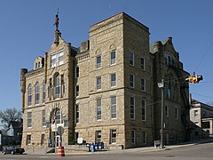
Keokuk County is a county located in the U.S. state of Iowa. As of the 2020 United States Census, the population was 10,033. The county seat is Sigourney.

<span class="mw-page-title-main">Jefferson County, Iowa</span> County in Iowa, United States

Jefferson County is a county located in the U.S. state of Iowa. As of the 2020 United States Census, the population was 15,663. The county seat is Fairfield. The county was formed in January 1839, and was named for U.S. President Thomas Jefferson.

<span class="mw-page-title-main">Henry County, Iowa</span> County in Iowa, United States

Henry County is a county located in the U.S. state of Iowa. As of the 2020 census, the population was 20,482. The county seat is Mount Pleasant. The county was named for General Henry Dodge, governor of Wisconsin Territory.

<span class="mw-page-title-main">Fremont County, Iowa</span> County in Iowa, United States

Fremont County is a county located in the U.S. state of Iowa. As of the 2020 census the population was 6,605, making it the state's seventh-least populous county. The county seat is Sidney. The county was formed in 1847 and named for the military officer John C. Frémont.

<span class="mw-page-title-main">Delaware County, Iowa</span> County in Iowa, United States

Delaware County is a county located in the U.S. state of Iowa. As of the 2020 census, the population was 17,488. The county seat is Manchester. The county takes its name after the U.S. state of Delaware.

<span class="mw-page-title-main">Davis County, Iowa</span> County in Iowa, United States

Davis County is a county located in the U.S. state of Iowa. As of the 2020 census, the population was 9,110. The county seat is Bloomfield.

<span class="mw-page-title-main">Hudson, Iowa</span> City in Iowa, United States

Hudson is a city in Black Hawk County, Iowa, United States. The population was 2,546 at the time of the 2020 census. The rural community of Hudson has grown in recent years and is included as a part of the Waterloo-Cedar Falls Metropolitan Statistical Area.

<span class="mw-page-title-main">Grandview, Iowa</span> City in Iowa, United States

Grandview is a city in Louisa County, Iowa, United States. The population was 437 at the time of the 2020 census. It is part of the Muscatine Micropolitan Statistical Area.

<span class="mw-page-title-main">Wapello, Iowa</span> City in Iowa, United States

Wapello is a city in and the county seat of Louisa County, Iowa, United States. The population was 2,084 at the time of the 2020 census.

<span class="mw-page-title-main">Chillicothe, Iowa</span> City in Iowa, United States

Chillicothe is a city in Wapello County, Iowa, United States. The population was 76 at the 2020 census.

<span class="mw-page-title-main">Eldon, Iowa</span> City in Iowa, United States

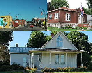
Eldon is a city in Wapello County, Iowa, United States. The population was 783 at the time of the 2020 census. It is the site of the small Carpenter Gothic style house that has come to be known as the American Gothic House. Artist Grant Wood used this home for the background in his world-famous 1930 painting American Gothic.

<span class="mw-page-title-main">Ottumwa, Iowa</span> City in Iowa, United States

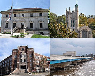
Ottumwa is a city in and the county seat of Wapello County, Iowa, United States. The population was 25,529 at the time of the 2020 U.S. Census. Located in the state's southeastern section, the city is split into northern and southern halves by the Des Moines River.

References

  1. 1 2 3 "2020 Census State Redistricting Data". census.gov. United states Census Bureau. Retrieved August 12, 2021.
  2. "Find a County". National Association of Counties. Retrieved June 7, 2011.
  3. "Wapello County". Archived from the original on April 26, 2007. Retrieved January 20, 2008.
  4. "US Gazetteer files: 2010, 2000, and 1990". United States Census Bureau. February 12, 2011. Retrieved April 23, 2011.
  5. "Annual Estimates of the Resident Population for Counties: April 1, 2020 to July 1, 2023". United States Census Bureau. Retrieved April 2, 2024.
  6. "U.S. Decennial Census". United States Census Bureau. Retrieved July 20, 2014.
  7. "Historical Census Browser". University of Virginia Library. Retrieved July 20, 2014.
  8. "Population of Counties by Decennial Census: 1900 to 1990". United States Census Bureau. Retrieved July 20, 2014.
  9. "Census 2000 PHC-T-4. Ranking Tables for Counties: 1990 and 2000" (PDF). United States Census Bureau. Archived (PDF) from the original on March 27, 2010. Retrieved July 20, 2014.
  10. "State & County QuickFacts". United States Census Bureau. Archived from the original on August 6, 2011. Retrieved July 20, 2014.
  11. "P2 HISPANIC OR LATINO, AND NOT HISPANIC OR LATINO BY RACE – 2020: DEC Redistricting Data (PL 94-171) – Wapello County, Iowa".
  12. "Population & Housing Occupancy Status 2010" (PDF). United States Census Bureau American FactFinder. Archived (PDF) from the original on October 16, 2020. Retrieved August 15, 2022.
  13. "U.S. Census website". United States Census Bureau . Retrieved January 31, 2008.
  14. Leip, David. "Dave Leip's Atlas of U.S. Presidential Elections". uselectionatlas.org. Retrieved April 28, 2018.

41°01′46″N92°24′32″W / 41.02944°N 92.40889°W / 41.02944; -92.40889