Cass County, Iowa

Last updated

Cass County
Cass Co IA Court House.jpg
Map of Iowa highlighting Cass County.svg
Location within the U.S. state of Iowa
Iowa in United States.svg
Iowa's location within the U.S.
Coordinates: 41°19′46″N94°55′45″W / 41.329444444444°N 94.929166666667°W / 41.329444444444; -94.929166666667
CountryFlag of the United States.svg United States
StateFlag of Iowa.svg  Iowa
Founded1851
Named for Lewis Cass
Seat Atlantic
Largest cityAtlantic
Area
  Total565 sq mi (1,460 km2)
  Land564 sq mi (1,460 km2)
  Water0.7 sq mi (2 km2)  0.1%
Population
 (2020)
  Total13,127
  Density23/sq mi (9.0/km2)
Time zone UTC−6 (Central)
  Summer (DST) UTC−5 (CDT)
Congressional district 3rd
Website www.casscountyia.gov

Cass County is a county located in the U.S. state of Iowa. As of the 2020 census, the population was 13,127. [1] Its county seat is Atlantic. [2] It was named to honor Lewis Cass, who was the 1848 Democratic nominee for president.

Contents

History

Cass County is named in honor of Lewis Cass, [3] a Michigan senator and an unsuccessful Democratic candidate for the presidency in 1848. The county was established within its present boundaries in 1851 and originated in 1853. Religious persecution was responsible for bringing the first people of European ancestry to Cass County. The Mormons, fleeing from Illinois, were the earliest settlers, and established a community at Indiantown in 1846.

At Indiantown, two of the three commissioners selected to locate a county seat were chosen. The site they chose was one mile (1.6 km) from Indiantown and named Lewis. Most of the people and businesses in Indian Town moved to Lewis shortly after it was laid out. In 1856, a frame courthouse was built, and eight years later a small stone building was completed for the county treasurer's office. In 1857, there was an attempt to relocate the county seat to Grove City; it was unsuccessful. On October 20, 1869, after a due canvass of the vote on the re-location of the county seat, the Board declared the city of Atlantic the county seat and ordered the county officers to that place.

Soils of Cass County Cass Co IA Pie Chart No Text Version.pdf
Soils of Cass County

In 1872, the first courthouse built in Atlantic was completed. Until it was completed county offices were held in various empty buildings. Ten years later the county built its second courthouse at Atlantic. The $65,000 building was destroyed by a fire in 1932. The fire started in the clock tower and gutted all of the second floor. Most of the county records and equipment were saved.

The present, fourth, courthouse was completed in 1934. While it was being built, county offices were located in the Atlantic Motors building, where an attempted robbery of the treasurer's safe took place. The robbers were interrupted and escaped, but without any money. The final cost of the fourth courthouse was $130,000: $65,000 came from a county bond issue, $46,500 from insurance and the remaining was covered by a Public Works Administration federal grant. The concrete and brick building is three stories high. It was dedicated on December 26, 1934, with the main speaker being the Governor of Iowa, Clyde L. Herring. The Board of Supervisors approved a new jail addition, which was dedicated in 1984.

Geography

According to the U.S. Census Bureau, the county has a total area of 565 square miles (1,460 km2), of which 564 square miles (1,460 km2) is land and 0.7 square miles (1.8 km2) (0.1%) is water. [4]

Major highways

Transit

Adjacent counties

Other Geographical notes

Due to its proximity to Cass County, Nebraska, and because both of those counties receive most of their broadcasts from Omaha, Nebraska, references to 'Cass County' must be frequently disambiguated, or result in confusion.[ citation needed ]

Demographics

Historical population
CensusPop.Note
1860 1,612
1870 5,464239.0%
1880 16,943210.1%
1890 19,64215.9%
1900 21,2748.3%
1910 19,047−10.5%
1920 19,4212.0%
1930 19,4220.0%
1940 18,647−4.0%
1950 18,532−0.6%
1960 17,919−3.3%
1970 17,007−5.1%
1980 16,932−0.4%
1990 15,128−10.7%
2000 14,684−2.9%
2010 13,956−5.0%
2020 13,127−5.9%
2023 (est.)13,130 [5] 0.0%
U.S. Decennial Census [6]
1790-1960 [7] 1900-1990 [8]
1990-2000 [9] 2010-2018 [10]
Population of Cass County from US census data CassCountyIowaPop2020.png
Population of Cass County from US census data

2020 census

2022 US Census population pyramid for Cass County from ACS 5-year estimates CassCountyIA2022PopPyr.png
2022 US Census population pyramid for Cass County from ACS 5-year estimates

The 2020 census recorded a population of 13,127 in the county, with a population density of

2010 census

The 2010 census recorded a population of 13,956 in the county, with a population density of

2000 census

As of the census [12] of 2000, there were 14,684 people, 6,120 households, and 4,094 families residing in the county. The population density was 26 people per square mile (10 people/km2). There were 6,590 housing units at an average density of 12 units per square mile (4.6 units/km2). The racial makeup of the county was 98.84% White, 0.21% Black or African American, 0.12% Native American, 0.14% Asian, 0.04% Pacific Islander, 0.31% from other races, and 0.34% from two or more races. 0.69% of the population were Hispanic or Latino of any race.

There were 6,120 households, out of which 29.30% had children under the age of 18 living with them, 56.60% were married couples living together, 7.20% had a female householder with no husband present, and 33.10% were non-families. 29.80% of all households were made up of individuals, and 15.90% had someone living alone who was 65 years of age or older. The average household size was 2.32 and the average family size was 2.87.

In the county, the population was spread out, with 23.80% under the age of 18, 6.80% from 18 to 24, 24.80% from 25 to 44, 23.80% from 45 to 64, and 20.80% who were 65 years of age or older. The median age was 42 years. For every 100 females there were 94.30 males. For every 100 females age 18 and over, there were 90.20 males.

The median income for a household in the county was $32,922, and the median income for a family was $40,564. Males had a median income of $29,736 versus $20,108 for females. The per capita income for the county was $17,067. About 7.20% of families and 11.10% of the population were below the poverty line, including 14.40% of those under age 18 and 10.10% of those age 65 or over.

Notable people

Communities

Cities

Townships

Cass County is divided into sixteen townships:

Population ranking

The population ranking of the following table is based on the 2020 census of Cass County. [1] county seat

RankCity/Town/etc.Municipal typePopulation (2020 Census)
1 Atlantic City6,792
2 Griswold City994
3 Anita City963
4 Massena City359
5 Lewis City357
6 Cumberland City251
7 Marne City110
8 Wiota City91

Politics

Cass County has historically been one of the most solidly Republican counties in Iowa. The only Democrat ever to win the county was Franklin D. Roosevelt in his 1932 landslide, taking the county by less than 2%. Despite Roosevelt winning by an even larger landslide nationally just four years later, he lost Cass County by more than 13%.

United States presidential election results for Cass County, Iowa [13]
Year Republican Democratic Third party
No.%No.%No.%
2020 4,96968.29%2,20130.25%1061.46%
2016 4,76166.82%1,95127.38%4135.80%
2012 4,21758.53%2,85839.67%1301.80%
2008 4,00654.49%3,21143.68%1351.84%
2004 4,79663.58%2,67935.52%680.90%
2000 4,20661.13%2,48136.06%1932.81%
1996 3,38449.29%2,61638.11%86512.60%
1992 3,17645.00%2,23131.61%1,65123.39%
1988 3,96256.86%2,93442.11%721.03%
1984 5,05367.10%2,41732.09%610.81%
1980 5,39166.34%2,17626.78%5596.88%
1976 4,58960.79%2,86637.97%941.25%
1972 5,23472.06%1,92326.48%1061.46%
1968 5,22367.30%2,13627.52%4025.18%
1964 4,18251.01%4,00648.87%100.12%
1960 6,29067.24%3,05932.70%50.05%
1956 6,10368.34%2,81831.56%90.10%
1952 7,35575.61%2,34924.15%230.24%
1948 5,10659.66%3,37239.40%810.95%
1944 5,61065.53%2,92834.20%230.27%
1940 6,37762.69%3,76336.99%320.31%
1936 5,62256.43%4,28443.00%560.56%
1932 4,21548.76%4,33950.19%911.05%
1928 6,12069.43%2,64029.95%550.62%
1924 5,72168.70%1,09913.20%1,50818.11%
1920 6,55878.23%1,66819.90%1571.87%
1916 2,76359.75%1,80138.95%601.30%
1912 1,72438.35%1,51033.59%1,26128.05%
1908 2,79961.19%1,65536.18%1202.62%
1904 3,05065.55%1,39429.96%2094.49%
1900 3,12860.12%2,01038.63%651.25%
1896 2,95956.11%2,24042.47%751.42%

See also

Related Research Articles

<span class="mw-page-title-main">Poweshiek County, Iowa</span> County in Iowa, United States

Poweshiek County is a county in the southeastern part of the U.S. state of Iowa. As of the 2020 census, the population was 18,662. The county seat is Montezuma. The county is named for the chief of the Fox tribe who signed the treaty ending the Black Hawk War. It lies along Interstate 80 between Des Moines and Iowa City. Poweshiek County's largest city is Grinnell.

<span class="mw-page-title-main">Shelby County, Iowa</span> County in Iowa, United States

Shelby County is a county located in the U.S. state of Iowa. As of the 2020 census, the population was 11,746. The county seat is Harlan. Its name is in honor of Isaac Shelby, the first Governor of Kentucky.

<span class="mw-page-title-main">Cass County, Nebraska</span> County in Nebraska, United States

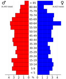
Cass County is a county in the U.S. state of Nebraska. As of the 2020 United States Census, the population was 26,598. Its county seat and largest city is Plattsmouth. The county was formed in 1855, and was named for General Lewis Cass, an American military officer, politician, and statesman.

<span class="mw-page-title-main">Warren County, Iowa</span> County in Iowa, United States

Warren County is a county located in the U.S. state of Iowa. As of the 2020 census, the population was 52,403. The county seat is Indianola.

<span class="mw-page-title-main">Scott County, Iowa</span> County in Iowa, United States

Scott County is a county located in the U.S. state of Iowa. As of the 2020 census, the population was 174,669, making it the third-most populous county in Iowa. The county seat is Davenport.

<span class="mw-page-title-main">Sac County, Iowa</span> County in Iowa, United States

Sac County is a county located in the U.S. state of Iowa. As of the 2020 census, the population was 9,814. The county seat is Sac City. Both were named for the Sauk people, a local American Indian tribe.

<span class="mw-page-title-main">Pottawattamie County, Iowa</span> County in Iowa, United States

Pottawattamie County is a county located in the U.S. state of Iowa. At the 2020 census, the population was 93,667, making it the tenth-most populous county in Iowa. The county takes its name from the Potawatomi Native American tribe. The county seat is Council Bluffs.

<span class="mw-page-title-main">Page County, Iowa</span> County in Iowa, United States

Page County is a county located in the U.S. state of Iowa. As of the 2020 census, the population was 15,211. The county seat is Clarinda. The county is named in honor of Captain John Page of the 4th U.S. Infantry, who was mortally wounded in the Battle of Palo Alto.

<span class="mw-page-title-main">Monona County, Iowa</span> County in Iowa, United States

Monona County is a county located in the U.S. state of Iowa. As of the 2020 census, the population was 8,751. The county seat is Onawa.

<span class="mw-page-title-main">Mahaska County, Iowa</span> County in Iowa, United States

Mahaska County is a county located in the U.S. state of Iowa. As of the 2020 census, the population was 22,190. The county seat is Oskaloosa.

<span class="mw-page-title-main">Iowa County, Iowa</span> County in Iowa, United States

Iowa County is a county located in the U.S. state of Iowa. As of the 2020 census, the population was 16,662. The county seat is Marengo.

<span class="mw-page-title-main">Henry County, Iowa</span> County in Iowa, United States

Henry County is a county located in the U.S. state of Iowa. As of the 2020 census, the population was 20,482. The county seat is Mount Pleasant. The county was named for General Henry Dodge, governor of Wisconsin Territory.

<span class="mw-page-title-main">Harrison County, Iowa</span> County in Iowa, United States

Harrison County is a county located in the U.S. state of Iowa. As of the 2020 census, the population was 14,582. The county seat is Logan. The county was formed in 1851. It was named for the ninth US President William Henry Harrison.

<span class="mw-page-title-main">Hardin County, Iowa</span> County in Iowa, United States

Hardin County is a county located in the U.S. state of Iowa. As of the 2020 census, the population was 16,878. The county seat is Eldora. The county was named in honor of Col. John J. Hardin, of Illinois, who was killed in the Mexican–American War.

<span class="mw-page-title-main">Greene County, Iowa</span> County in Iowa, United States

Greene County is a county located in the U.S. state of Iowa. As of the 2020 census, the population was 8,771. The county seat is Jefferson. The county is named in honor of General Nathanael Greene.

<span class="mw-page-title-main">Fremont County, Iowa</span> County in Iowa, United States

Fremont County is a county located in the U.S. state of Iowa. As of the 2020 census the population was 6,605, making it the state's seventh-least populous county. The county seat is Sidney. The county was formed in 1847 and named for the military officer John C. Frémont.

<span class="mw-page-title-main">Carroll County, Iowa</span> County in Iowa, United States

Carroll County is a county located in the U.S. state of Iowa. As of the 2020 census, the population was 20,760. Its county seat is Carroll. The county is named in honor of Charles Carroll of Carrollton, signer of the Declaration of Independence.

<span class="mw-page-title-main">Boone County, Iowa</span> County in Iowa, United States

Boone County is a county in the U.S. state of Iowa. As of the 2020 census, the population was 26,715. Its county seat is Boone.

<span class="mw-page-title-main">Audubon County, Iowa</span> County in Iowa, United States

Audubon County is a county in the U.S. state of Iowa. As of the 2020 census, the population was 5,674, making it Iowa's third-least populous county. Its county seat is Audubon. The county was named after John James Audubon, the naturalist and artist.

<span class="mw-page-title-main">Appanoose County, Iowa</span> County in Iowa, United States

Appanoose County is a county in the U.S. state of Iowa. As of the 2020 census, the population was 12,317. Its county seat is Centerville.

References

  1. 1 2 3 "2020 Census State Redistricting Data". census.gov. United states Census Bureau. Retrieved August 12, 2021.
  2. "Find a County". National Association of Counties. Archived from the original on May 31, 2011. Retrieved June 7, 2011.
  3. Gannett, Henry (1905). The Origin of Certain Place Names in the United States. Govt. Print. Off. pp.  71.
  4. "US Gazetteer files: 2010, 2000, and 1990". United States Census Bureau. February 12, 2011. Retrieved April 23, 2011.
  5. "Annual Estimates of the Resident Population for Counties: April 1, 2020 to July 1, 2023". United States Census Bureau. Retrieved April 2, 2024.
  6. "U.S. Decennial Census". United States Census Bureau. Retrieved July 14, 2014.
  7. "Historical Census Browser". University of Virginia Library. Retrieved July 14, 2014.
  8. "Population of Counties by Decennial Census: 1900 to 1990". United States Census Bureau. Retrieved July 14, 2014.
  9. "Census 2000 PHC-T-4. Ranking Tables for Counties: 1990 and 2000" (PDF). United States Census Bureau. Archived (PDF) from the original on March 27, 2010. Retrieved July 14, 2014.
  10. "State & County QuickFacts". United States Census Bureau. Archived from the original on June 7, 2011. Retrieved July 14, 2014.
  11. "Population and Housing Occupancy Status: 2010 State County". United States Census Bureau American FactFinder. Archived from the original on September 29, 2015. Retrieved March 8, 2011.
  12. "U.S. Census website". United States Census Bureau . Retrieved January 31, 2008.
  13. Leip, David. "Dave Leip's Atlas of U.S. Presidential Elections". uselectionatlas.org. Retrieved April 25, 2018.

41°19′46″N94°55′45″W / 41.32944°N 94.92917°W / 41.32944; -94.92917