Keokuk County, Iowa

Last updated

Keokuk County
Keokuk County, Iowa Courthouse.jpg
Courthouse in Sigourney is on the NRHP
Map of Iowa highlighting Keokuk County.svg
Location within the U.S. state of Iowa
Iowa in United States.svg
Iowa's location within the U.S.
Coordinates: 41°20′10″N92°10′47″W / 41.33611°N 92.17972°W / 41.33611; -92.17972
CountryFlag of the United States.svg United States
StateFlag of Iowa.svg  Iowa
FoundedFebruary 17, 1843
Named for Keokuk (Sauk leader)
Seat Sigourney
Largest citySigourney
Area
  Total580 sq mi (1,500 km2)
  Land579 sq mi (1,500 km2)
  Water0.7 sq mi (2 km2)  0.1%
Population
 (2020)
  Total10,033
  Density17/sq mi (6.7/km2)
Time zone UTC−6 (Central)
  Summer (DST) UTC−5 (CDT)
Congressional district 2nd
Website www.keokukcountyia.com

Keokuk County is a county located in the U.S. state of Iowa. As of the 2020 United States Census, the population was 10,033. [1] The county seat is Sigourney. [2]

Contents

History

Keokuk (Sauk chief) by George Catlin Keokuk 2.jpg
Keokuk (Sauk chief) by George Catlin

Keokuk County was formed in 1837. It was named for Keokuk, the leader of the Sauk tribe, who advocated peace with the white settlers. In May 1843, the county opened for public settlement, with its judicial and regulatory duties assigned to the existing Washington County. Its governing structure was created in 1844, although the seat was not decided (for Sigourney) until 1856. [3]

Keokuk County is unusual in that it has two county fairs. The Keokuk County Fair is held in What Cheer [4] and immediately followed by the Keokuk County Expo [5] which is held in Sigourney.

The Keokuk County Courthouse was built in 1911, in Sigourney's Public Square Historic District. It has been listed on the National Register of Historic Places since 1981. [6]

Geography

According to the United States Census Bureau, the county has a total area of 580 square miles (1,500 km2), of which 579 square miles (1,500 km2) is land and 0.7 square miles (1.8 km2) (0.1%) is water. [7] The South Branch of the Skunk River drains the topography, flowing eastward through the lower portion of the county. [8]

Major highways

Adjacent counties

Demographics

Historical population
CensusPop.Note
1850 4,822
1860 13,271175.2%
1870 19,43446.4%
1880 21,2589.4%
1890 23,86212.2%
1900 24,9794.7%
1910 21,160−15.3%
1920 20,983−0.8%
1930 19,148−8.7%
1940 18,406−3.9%
1950 16,797−8.7%
1960 15,492−7.8%
1970 13,943−10.0%
1980 12,921−7.3%
1990 11,624−10.0%
2000 11,400−1.9%
2010 10,511−7.8%
2020 10,033−4.5%
2023 (est.)9,914 [9] −1.2%
US Decennial Census [10]
1790-1960 [11] 1900-1990 [12]
1990-2000 [13] 2010-2018 [14]
Population of Keokuk County from US census data KeokukCountyIowaPop2020.png
Population of Keokuk County from US census data

2020 census

2022 US Census population pyramid for Keokuk County from ACS 5-year estimates KeokukCountyIA2022PopPyr.png
2022 US Census population pyramid for Keokuk County from ACS 5-year estimates

The 2020 census recorded a population of 10,033 in the county, with a population density of

2010 census

The 2010 census recorded a population of 10,511 in the county, with a population density of

2000 census

As of the 2000 United States Census, [16] there were 11,400 people, 4,586 households, and 3,155 families in the county. The population density was 20 people per square mile (7.7 people/km2). There were 5,013 housing units at an average density of 9 units per square mile (3.5 units/km2). The racial makeup of the county was 99.00% White, 0.07% Black or African American, 0.11% Native American, 0.23% Asian, 0.02% Pacific Islander, 0.21% from other races, and 0.36% from two or more races. 0.54% of the population were Hispanic or Latino of any race.

There were 4,586 households, out of which 30.50% had children under the age of 18 living with them, 59.00% were married couples living together, 6.50% had a female householder with no husband present, and 31.20% were non-families. 27.80% of all households were made up of individuals, and 15.80% had someone living alone who was 65 years of age or older. The average household size was 2.45 and the average family size was 2.99.

The county population contained 25.70% under the age of 18, 7.00% from 18 to 24, 25.50% from 25 to 44, 21.60% from 45 to 64, and 20.20% who were 65 years of age or older. The median age was 40 years. For every 100 females there were 94.10 males. For every 100 females age 18 and over, there were 91.80 males.

The median income for a household in the county was $34,025, and the median income for a family was $41,818. Males had a median income of $28,306 versus $22,083 for females. The per capita income for the county was $17,120. About 7.50% of families and 10.10% of the population were below the poverty line, including 12.90% of those under age 18 and 10.50% of those age 65 or over.

Politics

For most of its history, Keokuk County has backed Republican Party candidates in presidential elections, with Democratic Party candidates only winning the county in eight presidential elections from 1896 on. Bill Clinton is the most recent Democratic presidential candidate to win the county (1996), while in 2016 his wife, Hillary Clinton, had the worst performance by a Democrat since 1924, only winning 26.9 percent of the vote. 2016 Republican candidate Donald Trump made a significant gain compared to his party's 2012 candidate Mitt Romney.

United States presidential election results for Keokuk County, Iowa [17]
Year Republican Democratic Third party
No.%No.%No.%
2020 3,79771.60%1,41426.66%921.73%
2016 3,39068.00%1,34226.92%2535.08%
2012 2,84353.99%2,30343.73%1202.28%
2008 2,71250.58%2,51846.96%1322.46%
2004 3,11956.92%2,29441.86%671.22%
2000 2,57151.97%2,18144.09%1953.94%
1996 2,08040.78%2,54549.89%4769.33%
1992 1,98135.52%2,32941.76%1,26722.72%
1988 2,27843.56%2,89955.43%531.01%
1984 2,91351.50%2,64946.84%941.66%
1980 3,14552.64%2,39040.00%4407.36%
1976 2,92044.90%3,48253.54%1021.57%
1972 3,83158.35%2,61939.89%1151.75%
1968 3,58853.26%2,80741.67%3425.08%
1964 2,59735.08%4,79064.69%170.23%
1960 4,69757.88%3,40842.00%100.12%
1956 4,68056.13%3,64943.76%90.11%
1952 5,71264.20%3,13535.24%500.56%
1948 4,20149.57%4,11848.59%1561.84%
1944 4,64453.96%3,90045.32%620.72%
1940 5,39454.00%4,55245.57%420.42%
1936 4,49145.46%5,16252.26%2252.28%
1932 3,44236.74%5,83962.32%880.94%
1928 5,30458.23%3,77241.41%320.35%
1924 4,79551.36%2,56827.51%1,97321.13%
1920 6,20767.95%2,80030.65%1281.40%
1916 2,82252.18%2,48645.97%1001.85%
1912 1,36126.07%2,43446.63%1,42527.30%
1908 2,72850.71%2,45945.71%1933.59%
1904 3,07955.82%2,17239.38%2654.80%
1900 3,33954.32%2,66943.42%1392.26%
1896 3,16650.72%2,89146.32%1852.96%

Communities

Cities

Unincorporated communities

Townships

Population ranking

The population ranking of the following table is based on the 2020 census of Keokuk County. [1]

county seat

RankCity/Town/etc.Municipal typePopulation (2020 Census)
1 Sigourney City2,004
2 North English (mostly in Iowa County )City1,065
3 Keota City897
4 Hedrick City728
5 What Cheer City607
6 Richland City542
7 Keswick City242
8 South English City202
9 Ollie City201
10 Harper City118
11 Martinsburg City110
12 Webster City94
13 Kinross City80
14 Thornburg City45
15 Hayesville City41

Education

School districts include: [18]

Former school districts:

See also

Related Research Articles

<span class="mw-page-title-main">Winneshiek County, Iowa</span> County in Iowa, United States

Winneshiek County is a county located in the U.S. state of Iowa. As of the 2020 census, the population was 20,070. The county seat is Decorah.

<span class="mw-page-title-main">Wapello County, Iowa</span> County in Iowa, United States

Wapello County is a county located in the U.S. state of Iowa. As of the 2020 census, the population was 35,437. The county seat is Ottumwa. The county was formed on February 17, 1843, and named for Wapello, a Meskwaki chief.

<span class="mw-page-title-main">Tama County, Iowa</span> County in Iowa, United States

Tama County is a county located in the U.S. state of Iowa. As of the 2020 census, the population was 17,135. Its county seat is Toledo. The county was formed on February 17, 1843 and named for Taimah, a leader of the Meskwaki people.

<span class="mw-page-title-main">Pottawattamie County, Iowa</span> County in Iowa, United States

Pottawattamie County is a county located in the U.S. state of Iowa. At the 2020 census, the population was 93,667, making it the tenth-most populous county in Iowa. The county takes its name from the Potawatomi Native American tribe. The county seat is Council Bluffs.

<span class="mw-page-title-main">Polk County, Iowa</span> County in Iowa, United States

Polk County is located in the U.S. state of Iowa. As of the 2020 census, the population was 492,401. It is Iowa's most populous county, and home to over 15% of the state's residents. The county seat is Des Moines, which is also the capital city of Iowa. Polk County is included in the Des Moines–West Des Moines, IA Metropolitan Statistical Area.

<span class="mw-page-title-main">Lee County, Iowa</span> County in Iowa, United States

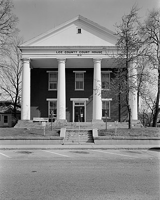
Lee County is the southernmost county in the U.S. state of Iowa. As of the 2020 census, the population was 33,555. The county seats are Fort Madison and Keokuk. Lee County is part of the Fort Madison–Keokuk, IA-IL-MO Micropolitan Statistical Area. It was established in 1836.

<span class="mw-page-title-main">Henry County, Iowa</span> County in Iowa, United States

Henry County is a county located in the U.S. state of Iowa. As of the 2020 census, the population was 20,482. The county seat is Mount Pleasant. The county was named for General Henry Dodge, governor of Wisconsin Territory.

<span class="mw-page-title-main">Hamilton County, Iowa</span> County in Iowa, United States

Hamilton County is a county located in the U.S. state of Iowa. As of the 2020 census, the population was 15,039. The county seat is Webster City. The county was named to honor William W. Hamilton, a President of the Iowa State Senate.

<span class="mw-page-title-main">Fremont County, Iowa</span> County in Iowa, United States

Fremont County is a county located in the U.S. state of Iowa. As of the 2020 census the population was 6,605, making it the state's seventh-least populous county. The county seat is Sidney. The county was formed in 1847 and named for the military officer John C. Frémont.

<span class="mw-page-title-main">Crawford County, Iowa</span> County in Iowa, United States

Crawford County is a county located in the U.S. state of Iowa. As of the 2020 census, the population was 16,525. Its county seat is Denison. The county was named for William Harris Crawford, U.S. senator from Georgia and United States Secretary of the Treasury.

<span class="mw-page-title-main">Benton County, Iowa</span> County in Iowa, United States

Benton County is a county in the U.S. state of Iowa. As of the 2020 census, the population was 25,575. Its county seat and largest city is Vinton. The county is named for Thomas Hart Benton, a U.S. Senator from Missouri.

<span class="mw-page-title-main">Delta, Iowa</span> City in Iowa, United States

Delta is a city in Keokuk County, Iowa, United States. The population was 264 at the 2020 census.

<span class="mw-page-title-main">Harper, Iowa</span> City in Iowa, United States

Harper is a city in Keokuk County, Iowa, United States. The population was 118 at the time of the 2020 census.

<span class="mw-page-title-main">Hayesville, Iowa</span> City in Iowa, United States

Hayesville is a city in Keokuk County, Iowa, United States. The population was 41 at the time of the 2020 census.

<span class="mw-page-title-main">Keota, Iowa</span> City in Iowa, United States

Keota is a city in Keokuk and Washington counties, Iowa, United States. The population was 897 at the time of the 2020 census.

<span class="mw-page-title-main">Sigourney, Iowa</span> City in Iowa, United States

Sigourney is a city in Keokuk County, Iowa, United States. The population was 2,004 at the time of the 2020 census. It is the county seat of Keokuk County. Keokuk County Courthouse is located in the Public Square Historic District. Both are on the National Register of Historic Places.

<span class="mw-page-title-main">Blakesburg, Iowa</span> City in Iowa, United States

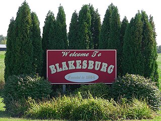
Blakesburg is a city in Wapello County, Iowa, United States. The population was 274 at the 2020 census.

<span class="mw-page-title-main">Chillicothe, Iowa</span> City in Iowa, United States

Chillicothe is a city in Wapello County, Iowa, United States. The population was 76 at the 2020 census.

<span class="mw-page-title-main">Kirkville, Iowa</span> City in Iowa, United States

Kirkville is a city in Wapello County, Iowa, United States. The population was 157 at the time of the 2020 census.

<span class="mw-page-title-main">Eddyville, Iowa</span> City in Iowa, United States

Eddyville is a city in Mahaska, Monroe, and Wapello counties in the U.S. state of Iowa. The population was 970 at the time of the 2020 census.

References

  1. 1 2 3 "2020 Census State Redistricting Data". census.gov. US Census Bureau. Retrieved August 12, 2021.
  2. "Find a County". National Association of Counties. Archived from the original on May 31, 2011. Retrieved June 7, 2011.
  3. "Keokuk County History". www.beforetime.net.
  4. "Keokuk County Fair - What Cheer, IA | JULY 9-12, 2015". keokukcountyfair.com.
  5. "Keokuk County Expo". expokeokukco.com.
  6. "National Register Information System". National Register of Historic Places . National Park Service. March 13, 2009.
  7. "US Gazetteer files: 2010, 2000, and 1990". United States Census Bureau. February 12, 2011. Retrieved April 23, 2011.
  8. 1 2 3 4 5 6 "Keokuk County, IA" . Retrieved October 17, 2021 via Google Maps.
  9. "Annual Estimates of the Resident Population for Counties: April 1, 2020 to July 1, 2023". United States Census Bureau. Retrieved April 2, 2024.
  10. "US Decennial Census". US Census Bureau. Retrieved July 18, 2014.
  11. "Historical Census Browser". University of Virginia Library. Retrieved July 18, 2014.
  12. "Population of Counties by Decennial Census: 1900 to 1990". US Census Bureau. Retrieved July 18, 2014.
  13. "Census 2000 PHC-T-4. Ranking Tables for Counties: 1990 and 2000" (PDF). US Census Bureau. Archived (PDF) from the original on March 27, 2010. Retrieved July 18, 2014.
  14. "State & County QuickFacts". US Census Bureau. Archived from the original on June 7, 2011. Retrieved July 18, 2014.
  15. "Population & Housing Occupancy Status 2010" (PDF). US Census Bureau – American FactFinder. Archived (PDF) from the original on October 16, 2020. Retrieved August 15, 2022.
  16. "US Census website". US Census Bureau. Retrieved January 31, 2008.
  17. Leip, David. "Atlas of US Presidential Elections". uselectionatlas.org. Retrieved April 26, 2018.
  18. "2020 CENSUS - SCHOOL DISTRICT REFERENCE MAP: Keokuk County, IA" (PDF). U.S. Census Bureau. Archived (PDF) from the original on July 19, 2022. Retrieved July 19, 2022. - Text list
  19. "SCHOOL DISTRICT REFERENCE MAP (2010 CENSUS): Keokuk County, IA" (PDF). U.S. Census Bureau . Retrieved July 19, 2022. - Text list