Ida County, Iowa

Last updated

Ida County
Ida County IA Courthouse.jpg
Map of Iowa highlighting Ida County.svg
Location within the U.S. state of Iowa
Iowa in United States.svg
Iowa's location within the U.S.
Coordinates: 42°23′12″N95°30′52″W / 42.386666666667°N 95.514444444444°W / 42.386666666667; -95.514444444444
CountryFlag of the United States.svg United States
StateFlag of Iowa.svg  Iowa
FoundedJanuary 15, 1851
Seat Ida Grove
Largest cityIda Grove
Area
  Total432 sq mi (1,120 km2)
  Land432 sq mi (1,120 km2)
  Water0.5 sq mi (1 km2)  0.1%
Population
 (2020)
  Total7,005
  Density16/sq mi (6.3/km2)
Time zone UTC−6 (Central)
  Summer (DST) UTC−5 (CDT)
Congressional district 4th
Website idacounty.iowa.gov

Ida County is a county located in the U.S. state of Iowa. As of the 2020 census the population was 7,005, making it the state's eighth-least populous county. [1] The county seat is Ida Grove. [2] The county was authorized by the Iowa Legislature in January 1851 as a packet of projected counties in unorganized territory of western Iowa. It was named after Ida Smith, the first child of European immigrants to be born in this region. [3]

Contents

History

The Iowa Legislature authorized the formation of 49 counties in previously–unregulated western Iowa on January 15, 1851. [4] This date is usually cited as the date of formation of Ida County; however, as there were no inhabitants of that area, no action was taken to form a county government.

On January 12, 1853, the Legislature authorized creation of Woodbury County, and included the proviso that the area of Ida County be included with Woodbury for revenue, election, and judicial purposes. In 1853 there were still no settlers in Ida County's lands. [3]

The county's first permanent settlers (Comstock and Moorehead) arrived in 1856. In 1858 the county government was organized, with John Moorehead appointed County Judge. There were about 40 county residents at that time. [3]

The county's only postoffice, as well as the first courthouse, was operated from Judge Moorehead's house. [5]

The county's first dedicated school building was raised in 1861. [3]

The county's first newspaper, Ida County Pioneer, was started in 1872. The first bank opened in 1876. Railroads arrived in Ida County in 1877, when the Maple Valley branch of the Chicago & North Western Railway was built. This resulted in a flood of settlers, and within five years, nearly all the available land had been purchased. [3]

Geography

According to the U.S. Census Bureau, the county has a total area of 432 square miles (1,120 km2), of which 432 square miles (1,120 km2) is land and 0.5 square miles (1.3 km2) (0.1%) is water. [6]

Major highways

Adjacent counties

Demographics

Historical population
CensusPop.Note
1860 43
1870 226425.6%
1880 4,3821,838.9%
1890 10,705144.3%
1900 12,32715.2%
1910 11,296−8.4%
1920 11,6893.5%
1930 11,9332.1%
1940 11,047−7.4%
1950 10,697−3.2%
1960 10,269−4.0%
1970 9,283−9.6%
1980 8,908−4.0%
1990 8,365−6.1%
2000 7,837−6.3%
2010 7,089−9.5%
2020 7,005−1.2%
2023 (est.)6,833 [7] −2.5%
U.S. Decennial Census [8]
1790-1960 [9] 1900-1990 [10]
1990-2000 [11] 2010-2018 [12] [13] 2020-2022 [12]
Population of Ida County from US census data IdaCountyIowaPop2020.png
Population of Ida County from US census data

2020 census

2022 US Census population pyramid for Ida County from ACS 5-year estimates IdaCountyIA2022PopPyr.png
2022 US Census population pyramid for Ida County from ACS 5-year estimates

The 2020 census recorded a population of 7,005 in the county, with a population density of

2010 census

The 2010 census recorded a population of 7,089 in the county, with a population density of

2000 census

As of the census [15] of 2000, there were 7,837 people, 3,213 households, and 2,184 families residing in the county. The population density was 18 people per square mile (6.9 people/km2). There were 3,506 housing units at an average density of 8 units per square mile (3.1 units/km2). The racial makeup of the county was 99.02% White, 0.10% Black or African American, 0.06% Native American, 0.24% Asian, 0.15% from other races, and 0.42% from two or more races. 0.47% of the population were Hispanic or Latino of any race.

There were 3,213 households, out of which 29.40% had children under the age of 18 living with them, 59.50% were married couples living together, 5.90% had a female householder with no husband present, and 32.00% were non-families. 29.30% of all households were made up of individuals, and 15.90% had someone living alone who was 65 years of age or older. The average household size was 2.39 and the average family size was 2.95.

In the county, the population was spread out, with 25.50% under the age of 18, 6.10% from 18 to 24, 24.00% from 25 to 44, 22.70% from 45 to 64, and 21.80% who were 65 years of age or older. The median age was 42 years. For every 100 females there were 93.90 males. For every 100 females age 18 and over, there were 91.40 males.

The median income for a household in the county was $34,805, and the median income for a family was $43,179. Males had a median income of $29,002 versus $19,417 for females. The per capita income for the county was $18,675. About 5.70% of families and 8.80% of the population were below the poverty line, including 9.10% of those under age 18 and 8.60% of those age 65 or over.

Communities

Cities

Unincorporated communities

Townships

Population ranking

The population ranking of the following table is based on the 2020 census of Ida County. [1]

county seat

RankCity/Town/etc.Municipal typePopulation (2020 Census)
1 Ida Grove City2,051
2 Holstein City1,501
3 Battle Creek City700
4 Galva City435
5 Arthur City222

Politics

United States presidential election results for Ida County, Iowa [16]
Year Republican Democratic Third party
No.%No.%No.%
2020 2,88074.82%91723.82%521.35%
2016 2,65573.50%79221.93%1654.57%
2012 2,28662.41%1,32136.06%561.53%
2008 2,03657.40%1,45440.99%571.61%
2004 2,34262.06%1,41537.49%170.45%
2000 1,96856.37%1,41140.42%1123.21%
1996 1,68445.12%1,58942.58%45912.30%
1992 1,71440.43%1,44934.18%1,07625.38%
1988 1,95151.63%1,78747.29%411.08%
1984 2,61862.30%1,55937.10%250.59%
1980 2,82564.88%1,23528.36%2946.75%
1976 2,59056.86%1,86841.01%972.13%
1972 2,81964.67%1,49034.18%501.15%
1968 2,75362.21%1,46333.06%2094.72%
1964 1,97740.48%2,90559.48%20.04%
1960 3,29062.77%1,94937.19%20.04%
1956 3,22660.75%2,08339.23%10.02%
1952 3,80070.14%1,60329.59%150.28%
1948 2,25748.04%2,36550.34%761.62%
1944 2,64057.38%1,94342.23%180.39%
1940 3,16657.70%2,30642.03%150.27%
1936 1,83434.39%3,39763.70%1021.91%
1932 1,45227.99%3,66170.58%741.43%
1928 2,48652.77%2,17246.10%531.13%
1924 2,03343.46%68514.64%1,96041.90%
1920 3,54775.73%1,09023.27%471.00%
1916 1,41251.12%1,24445.04%1063.84%
1912 53018.98%1,08738.93%1,17542.08%
1908 1,36752.98%1,18145.78%321.24%
1904 1,56560.66%94036.43%752.91%
1900 1,59954.22%1,30444.22%461.56%
1896 1,47550.36%1,42148.51%331.13%

Education

School districts include: [17]

Former school districts: [18]

See also

Related Research Articles

<span class="mw-page-title-main">Wright County, Iowa</span> County in Iowa, United States

Wright County is a county in the U.S. state of Iowa. As of the 2020 census, the population was 12,943. The county seat is Clarion. The county organization became effective in January 1851, and is believed to be named either after Silas Wright, a governor of New York, or Joseph Albert Wright, a governor of Indiana.

<span class="mw-page-title-main">Woodbury County, Iowa</span> County in Iowa, United States

Woodbury County is a county located in the U.S. state of Iowa. As of the 2020 census, the population was 105,941, making it the sixth-most populous county in Iowa. The county seat is Sioux City.

<span class="mw-page-title-main">Sac County, Iowa</span> County in Iowa, United States

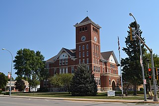
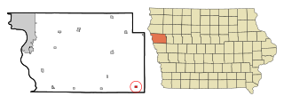
Sac County is a county located in the U.S. state of Iowa. As of the 2020 census, the population was 9,814. The county seat is Sac City. Both were named for the Sauk people, a local American Indian tribe.

<span class="mw-page-title-main">Crawford County, Iowa</span> County in Iowa, United States

Crawford County is a county located in the U.S. state of Iowa. As of the 2020 census, the population was 16,525. Its county seat is Denison. The county was named for William Harris Crawford, U.S. senator from Georgia and United States Secretary of the Treasury.

<span class="mw-page-title-main">Minburn, Iowa</span> City in Iowa, United States

Minburn is a city in Dallas County, Iowa, United States. The population was 325 at the time of the 2020 census. It is part of the Des Moines–West Des Moines Metropolitan Statistical Area.

<span class="mw-page-title-main">Arthur, Iowa</span> City in Iowa, United States

Arthur is an urban settlement in Ida County, Iowa, United States. The population was 222 at the 2020 census.

<span class="mw-page-title-main">Battle Creek, Iowa</span> City in Iowa, United States

Battle Creek is a city in Ida County, Iowa, United States. The population was 700 at the 2020 census.

<span class="mw-page-title-main">Galva, Iowa</span> City in Iowa, United States

Galva is a city in Ida County, Iowa, United States. The population was 435 at the time of the 2020 census.

<span class="mw-page-title-main">Holstein, Iowa</span> City in Iowa, United States

Holstein is a city in Ida County, Iowa, United States. The population was 1,501 in the 2020 census, a 2% increase from 1,470 in 2000.

<span class="mw-page-title-main">Ida Grove, Iowa</span> City in Iowa, United States

Ida Grove is a city in Ida County, Iowa, United States. The population was 2,051 at the time of the 2020 census. It is the county seat of Ida County.

<span class="mw-page-title-main">Mapleton, Iowa</span> City in Iowa, United States

Mapleton is a city in Monona County, Iowa, United States. The population was 1,165 at the time of the 2020 census.

<span class="mw-page-title-main">Rodney, Iowa</span> City in Iowa, United States

Rodney is a city in Monona County, Iowa, United States. The population was 45 at the time of the 2020 census.

<span class="mw-page-title-main">Early, Iowa</span> City in Iowa, United States

Early is a city in Sac County, Iowa, United States. The population was 587 at the 2020 census.

<span class="mw-page-title-main">Odebolt, Iowa</span> City in Iowa, United States

Odebolt is a city in Sac County, Iowa, United States. The population was 994 at the time of the 2020 census.

<span class="mw-page-title-main">Anthon, Iowa</span> City in Iowa, United States

Anthon is a city in Woodbury County, Iowa, United States. It is part of the Sioux City, IA–NE–SD Metropolitan Statistical Area. The population was 545 at the 2020 census.

<span class="mw-page-title-main">Danbury, Iowa</span> City in Iowa, United States

Danbury is a city in Woodbury County, Iowa, United States. It is part of the Sioux City, IA–NE–SD Metropolitan Statistical Area. The population was 320 at the time of the 2020 census. Danbury has two churches, St. Mary's Catholic Church and the United Methodist Church. Danbury holds a fall celebration called Corn Days during harvest.

<span class="mw-page-title-main">Oto, Iowa</span> City in Iowa, United States

Oto is a city in Woodbury County, Iowa, United States. It is part of the Sioux City, IA–NE–SD Metropolitan Statistical Area. The population was 72 at the time of the 2020 census.

<span class="mw-page-title-main">Maple Grove, Minnesota</span> City in Minnesota, United States

Maple Grove is a suburban city in Hennepin County, Minnesota, United States. The population was 70,253 at the 2020 census. making it Minnesota's 11th most populous city.

<span class="mw-page-title-main">Western Valley Activities Conference</span>

The Western Valley Activities Conference is an athletic conference for small high schools in Western Iowa. Formed in 2008 from the merger of the longstanding Maple Valley Conference and Boyer Valley Conference, the league now consists of 9 schools from the old Maple Valley Conference and Siouxland Christian.

Battle Creek–Ida Grove Community School District was a school district headquartered in Ida Grove, Iowa, which served that city and Battle Creek. Established in 1994, it became a part of the consolidated Odebolt–Arthur–Battle Creek–Ida Grove Community School District effective July 1, 2018.

References

  1. 1 2 3 "2020 Census State Redistricting Data". census.gov. United states Census Bureau. Retrieved August 12, 2021.
  2. "Find a County". National Association of Counties. Archived from the original on May 31, 2011. Retrieved June 7, 2011.
  3. 1 2 3 4 5 Ida County History
  4. IOWA - Consolidated Chronology of State and County Government. 50 counties were affected: 49 new counties were created, and Pottawattamie County was enlarged with a portion of Non-County Area 3 that had been attached to Mahaska County. See Iowa Acts 1850-51, chapter 9. Section 26 delineates the new Ida County.
  5. John Moorehead was named Postmaster of Ida PO on July 21, 1857. See Ida County History.
  6. "US Gazetteer files: 2010, 2000, and 1990". US Census Bureau. February 12, 2011. Retrieved April 23, 2011.
  7. "Annual Estimates of the Resident Population for Counties: April 1, 2020 to July 1, 2023". United States Census Bureau. Retrieved April 2, 2024.
  8. "U.S. Decennial Census". US Census Bureau. Retrieved July 17, 2014.
  9. "Historical Census Browser". University of Virginia Library. Retrieved July 17, 2014.
  10. "Population of Counties by Decennial Census: 1900 to 1990". US Census Bureau. Retrieved July 17, 2014.
  11. "Census 2000 PHC-T-4. Ranking Tables for Counties: 1990 and 2000" (PDF). US Census Bureau. Archived (PDF) from the original on March 27, 2010. Retrieved July 17, 2014.
  12. 1 2 "State & County QuickFacts". United States Census Bureau. Archived from the original on June 7, 2011. Retrieved July 17, 2014.
  13. https://www.census.gov/quickfacts/fact/table/keyapahacountynebraska/PST045222.{{cite web}}: Missing or empty |title= (help)
  14. "Population & Housing Occupancy Status 2010" (PDF). US Census Bureau – American FactFinder. Archived (PDF) from the original on October 16, 2020. Retrieved August 15, 2022.
  15. "U.S. Census website". US Census Bureau. Retrieved January 31, 2008.
  16. Leip, David. "Dave Leip's Atlas of U.S. Presidential Elections". uselectionatlas.org. Retrieved April 26, 2018.
  17. "2020 CENSUS - SCHOOL DISTRICT REFERENCE MAP: Ida County, IA" (PDF). U.S. Census Bureau. Archived (PDF) from the original on July 21, 2022. Retrieved July 21, 2022. - Text list
  18. "SCHOOL DISTRICT REFERENCE MAP (2010 CENSUS): Ida County, IA" (PDF). U.S. Census Bureau. Archived (PDF) from the original on July 21, 2022. Retrieved July 21, 2022. - Text list

42°23′12″N95°30′52″W / 42.38667°N 95.51444°W / 42.38667; -95.51444