Iowa County, Iowa

Last updated

Iowa County
Iowa County Courthouse, Marengo.jpg
Map of Iowa highlighting Iowa County.svg
Location within the U.S. state of Iowa
Iowa in United States.svg
Iowa's location within the U.S.
Coordinates: 41°41′10″N92°04′01″W / 41.686111111111°N 92.066944444444°W / 41.686111111111; -92.066944444444
CountryFlag of the United States.svg United States
StateFlag of Iowa.svg  Iowa
Founded1843
Named for Iowa River
Seat Marengo
Largest city Williamsburg
Area
  Total587 sq mi (1,520 km2)
  Land586 sq mi (1,520 km2)
  Water1.0 sq mi (3 km2)  0.2%
Population
 (2020)
  Total16,662
  Density28/sq mi (11/km2)
Time zone UTC−6 (Central)
  Summer (DST) UTC−5 (CDT)
Congressional district 1st
Website iowacounty.iowa.gov

Iowa County is a county located in the U.S. state of Iowa. As of the 2020 census, the population was 16,662. [1] The county seat is Marengo. [2]

Contents

Iowa County is one of seven counties in the United States to share the same name as the state they are located in. The other six counties are Arkansas County, Hawaii County, Idaho County, New York County, Oklahoma County, and Utah County. [3]

History

Iowa County was formed on February 17, 1843. It was named for the Iowa River, which flows through the county. [4]

The first courthouse was a log cabin built in 1847. This was rented by the county until 1850 when a second courthouse was completed. In 1861 construction of a third courthouse was begun. The current courthouse was built in 1892 after the county had outgrown the previous one. [5]

Iowa County is home to the Amana Colonies, a group of settlements of German Pietists, comprising seven villages. Calling themselves the Ebenezer Society or the Community of True Inspiration (German: die Gemeinde der wahren Inspiration), they first settled in New York state near Buffalo in what is now West Seneca. However, in order to live out their beliefs in more isolated surroundings they moved west, to Iowa County in 1855, living a communal life until the mid-1930s. Today, Amana is a major tourist attraction known mainly for its restaurants and craft shops, and the colonies as a whole have been listed as a National Historic Landmark since 1965.

Geography

According to the U.S. Census Bureau, the county has a total area of 587 square miles (1,520 km2), of which 586 square miles (1,520 km2) is land and 1.0 square mile (2.6 km2) (0.2%) is water. [6]

The county is intersected by the Iowa River and the north fork of the English River. [7]

Major highways

Adjacent counties

Demographics

Historical population
CensusPop.Note
1850 822
1860 8,029876.8%
1870 16,644107.3%
1880 19,22115.5%
1890 18,270−4.9%
1900 19,5447.0%
1910 18,409−5.8%
1920 18,6001.0%
1930 17,332−6.8%
1940 17,016−1.8%
1950 15,835−6.9%
1960 16,3963.5%
1970 15,419−6.0%
1980 15,4290.1%
1990 14,630−5.2%
2000 15,6717.1%
2010 16,3554.4%
2020 16,6621.9%
2023 (est.)16,381 [8] −1.7%
U.S. Decennial Census [9]
1790-1960 [10] 1900-1990 [11]
1990-2000 [12] 2010-2018 [13]
Population of Iowa County from US census data IowaCountyIowaPop2020.png
Population of Iowa County from US census data

2020 census

2022 US Census population pyramid for Iowa County from ACS 5-year estimates IowaCountyIA2022PopPyr.png
2022 US Census population pyramid for Iowa County from ACS 5-year estimates

The 2020 census recorded a population of 16,662 in the county, with a population density of

2010 census

The 2010 census recorded a population of 16,355 in the county, with a population density of

2000 census

As of the census [15] of 2000, there were 15,671 people, 6,163 households, and 4,301 families residing in the county. The population density was 27 people per square mile (10 people/km2). There were 6,545 housing units at an average density of 11 units per square mile (4.2 units/km2). The racial makeup of the county was 98.70% White, 0.17% Black or African American, 0.06% Native American, 0.30% Asian, 0.03% Pacific Islander, 0.36% from other races, and 0.38% from two or more races. 0.97% of the population were Hispanic or Latino of any race.

There were 6,163 households, out of which 32.80% had children under the age of 18 living with them, 60.10% were married couples living together, 6.60% had a female householder with no husband present, and 30.20% were non-families. 25.90% of all households were made up of individuals, and 12.50% had someone living alone who was 65 years of age or older. The average household size was 2.50 and the average family size was 3.03.

In the county, the population was spread out, with 26.40% under the age of 18, 6.30% from 18 to 24, 27.80% from 25 to 44, 22.40% from 45 to 64, and 17.10% who were 65 years of age or older. The median age was 39 years. For every 100 females there were 95.00 males. For every 100 females age 18 and over, there were 93.20 males.

The median income for a household in the county was $41,222, and the median income for a family was $48,946. Males had a median income of $31,220 versus $24,652 for females. The per capita income for the county was $18,884. About 3.40% of families and 5.00% of the population were below the poverty line, including 4.50% of those under age 18 and 5.40% of those age 65 or over.

Politics

In the 2008 US presidential election, a nearly equal number of Iowa County voters voted for each major candidate. [16]

In the 2012 US presidential election, Mitt Romney received 4,551 votes (51.8%). [17]

In the 2016 US presidential election, Donald Trump received 5,193 votes (59.1%). [18]

In the 2020 US presidential election, Donald Trump received 6,009 votes (61.8%). [19]

United States presidential election results for Iowa County, Iowa [20]
Year Republican Democratic Third party
No.%No.%No.%
2020 6,00961.68%3,54736.41%1861.91%
2016 5,20558.46%3,08434.64%6156.91%
2012 4,56951.53%4,14446.74%1531.73%
2008 4,18848.99%4,20249.16%1581.85%
2004 4,54453.75%3,84145.43%690.82%
2000 3,89452.53%3,23043.57%2893.90%
1996 3,04243.24%3,35447.68%6399.08%
1992 2,65638.13%2,56036.76%1,74925.11%
1988 3,24748.57%3,33849.93%1001.50%
1984 4,35260.02%2,81538.82%841.16%
1980 4,15355.21%2,60634.65%76310.14%
1976 3,92652.98%3,36745.43%1181.59%
1972 4,20260.34%2,57837.02%1842.64%
1968 4,13358.12%2,58636.37%3925.51%
1964 2,82839.82%4,26160.00%130.18%
1960 4,94463.47%2,82836.30%180.23%
1956 4,87562.68%2,75335.40%1491.92%
1952 5,62567.27%2,51430.06%2232.67%
1948 3,65952.44%3,03043.42%2894.14%
1944 3,95953.94%3,11942.49%2623.57%
1940 4,69655.33%3,64942.99%1431.68%
1936 3,36043.57%4,16353.98%1892.45%
1932 2,62835.04%4,37658.35%4956.60%
1928 4,09156.85%3,07542.73%300.42%
1924 3,54951.91%1,45821.33%1,83026.77%
1920 4,89269.92%2,01928.86%861.23%
1916 2,48457.90%1,76341.10%431.00%
1912 1,23730.76%1,84145.77%94423.47%
1908 2,23052.58%1,90744.97%1042.45%
1904 2,30352.81%1,89143.36%1673.83%
1900 2,33652.70%1,98344.73%1142.57%
1896 2,39153.78%1,95643.99%992.23%

Communities

Cities

Census-designated places

Other unincorporated communities

Townships

Population ranking

The population ranking of the following table is based on the 2020 census of Iowa County. [1]

county seat

RankCity/Town/etc.Municipal typePopulation (2020 Census)
1 Williamsburg City3,346
2 Marengo City2,435
3 North English (partially in Keokuk County )City1,065
4 Victor (partially in Poweshiek County )City875
5 Middle Amana CDP543
6 Amana CDP388
7 Conroy CDP252
8 Ladora City229
9 Parnell City194
10 South Amana CDP165
11 West Amana CDP140
t-12 Millersburg City135
t-12 Homestead CDP135
13 High Amana CDP113
14 East Amana CDP64

Education

The following public school districts have areas in Iowa County:

See also

Related Research Articles

<span class="mw-page-title-main">Clay County, Iowa</span> County in Iowa, United States

Clay County is a county located in the U.S. state of Iowa. As of the 2020 census, the population was 16,384. Its county seat is Spencer. Its name is in honor of Henry Clay Jr., a colonel who died in action in the Mexican–American War, and son of Henry Clay, famous American statesman from Kentucky.

<span class="mw-page-title-main">Poweshiek County, Iowa</span> County in Iowa, United States

Poweshiek County is a county in the southeastern part of the U.S. state of Iowa. As of the 2020 census, the population was 18,662. The county seat is Montezuma. The county is named for the chief of the Fox tribe who signed the treaty ending the Black Hawk War. It lies along Interstate 80 between Des Moines and Iowa City. Poweshiek County's largest city is Grinnell.

<span class="mw-page-title-main">Marengo County, Alabama</span> County in Alabama, United States

Marengo County is a county located in the west central portion of the U.S. state of Alabama. As of the 2020 census, the population was 19,323. The largest city is Demopolis, and the county seat is Linden. It is named in honor of the Battle of Marengo near Turin, Italy, where French leader Napoleon Bonaparte defeated the Austrians on June 14, 1800.

<span class="mw-page-title-main">Wright County, Iowa</span> County in Iowa, United States

Wright County is a county in the U.S. state of Iowa. As of the 2020 census, the population was 12,943. The county seat is Clarion. The county organization became effective in January 1851, and is believed to be named either after Silas Wright, a governor of New York, or Joseph Albert Wright, a governor of Indiana.

<span class="mw-page-title-main">Sioux County, Iowa</span> County in Iowa, United States

Sioux County is a county located in the U.S. state of Iowa. As of the 2020 census, the population was 35,872. Its county seat is Orange City. Its largest city is Sioux Center.

<span class="mw-page-title-main">Scott County, Iowa</span> County in Iowa, United States

Scott County is a county located in the U.S. state of Iowa. As of the 2020 census, the population was 174,669, making it the third-most populous county in Iowa. The county seat is Davenport.

<span class="mw-page-title-main">Sac County, Iowa</span> County in Iowa, United States

Sac County is a county located in the U.S. state of Iowa. As of the 2020 census, the population was 9,814. The county seat is Sac City. Both were named for the Sauk people, a local American Indian tribe.

<span class="mw-page-title-main">Polk County, Iowa</span> County in Iowa, United States

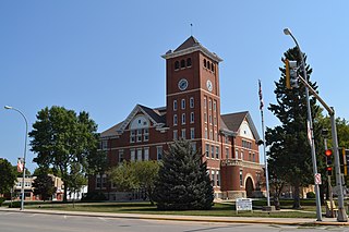
Polk County is located in the U.S. state of Iowa. As of the 2020 census, the population was 492,401. It is Iowa's most populous county, and home to over 15% of the state's residents. The county seat is Des Moines, which is also the capital city of Iowa. Polk County is included in the Des Moines–West Des Moines, IA Metropolitan Statistical Area.

<span class="mw-page-title-main">Muscatine County, Iowa</span> County in Iowa, United States

Muscatine County is a county located in the U.S. state of Iowa. As of the 2020 census, the population was 43,235. The county seat is Muscatine. The southeastern border is formed by the Mississippi River.

<span class="mw-page-title-main">Monroe County, Iowa</span> County in Iowa, United States

Monroe County is a county located in the south central part of the U.S. state of Iowa. In the early 20th century, it was a center of bituminous coal mining and in 1910 had a population of more than 25,000. As mining declined, people moved elsewhere for work. In the 2020 census, the population was 7,577. The county seat is Albia. The county, originally called Kishkekosh County after a famous chief of the Meskwaki, was renamed for James Monroe, fifth President of the United States.

<span class="mw-page-title-main">Mitchell County, Iowa</span> County in Iowa, United States

Mitchell County is a county located in the U.S. state of Iowa. As of the 2020 census, the population was 10,565. The county seat is Osage. It is not clear whom the county is named after: the county website mentions John Mitchell, an early surveyor, and an Irish patriot John Mitchel.

<span class="mw-page-title-main">Lee County, Iowa</span> County in Iowa, United States

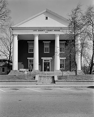
Lee County is the southernmost county in the U.S. state of Iowa. As of the 2020 census, the population was 33,555. The county seats are Fort Madison and Keokuk. Lee County is part of the Fort Madison–Keokuk, IA-IL-MO Micropolitan Statistical Area. It was established in 1836.

<span class="mw-page-title-main">Keokuk County, Iowa</span> County in Iowa, United States

Keokuk County is a county located in the U.S. state of Iowa. As of the 2020 United States Census, the population was 10,033. The county seat is Sigourney.

<span class="mw-page-title-main">Ida County, Iowa</span> County in Iowa, United States

Ida County is a county located in the U.S. state of Iowa. As of the 2020 census the population was 7,005, making it the state's eighth-least populous county. The county seat is Ida Grove. The county was authorized by the Iowa Legislature in January 1851 as a packet of projected counties in unorganized territory of western Iowa. It was named after Ida Smith, the first child of European immigrants to be born in this region.

<span class="mw-page-title-main">Henry County, Iowa</span> County in Iowa, United States

Henry County is a county located in the U.S. state of Iowa. As of the 2020 census, the population was 20,482. The county seat is Mount Pleasant. The county was named for General Henry Dodge, governor of Wisconsin Territory.

<span class="mw-page-title-main">Hardin County, Iowa</span> County in Iowa, United States

Hardin County is a county located in the U.S. state of Iowa. As of the 2020 census, the population was 16,878. The county seat is Eldora. The county was named in honor of Col. John J. Hardin, of Illinois, who was killed in the Mexican–American War.

<span class="mw-page-title-main">Fremont County, Iowa</span> County in Iowa, United States

Fremont County is a county located in the U.S. state of Iowa. As of the 2020 census the population was 6,605, making it the state's seventh-least populous county. The county seat is Sidney. The county was formed in 1847 and named for the military officer John C. Frémont.

<span class="mw-page-title-main">Benton County, Iowa</span> County in Iowa, United States

Benton County is a county in the U.S. state of Iowa. As of the 2020 census, the population was 25,575. Its county seat and largest city is Vinton. The county is named for Thomas Hart Benton, a U.S. Senator from Missouri.

<span class="mw-page-title-main">Marengo, Iowa</span> Town in Iowa, United States

Marengo is a town in and the county seat of Iowa County, Iowa, United States. It has served as the county seat since August 1845, even though it was not incorporated until July 1859. The population was 2,435 in the 2020 census, a decline from 2,535 in 2000.

Homestead is an unincorporated community in Iowa County, Iowa, United States. It has the ZIP code 52236.

References

  1. 1 2 3 "2020 Census State Redistricting Data". census.gov. United states Census Bureau. Retrieved August 12, 2021.
  2. "Find a County". National Association of Counties. Archived from the original on May 31, 2011. Retrieved June 7, 2011.
  3. Joseph Nathan Kane; Charles Curry Aiken (2005). The American Counties: Origins of County Names, Dates of Creation, and Population Data, 1950-2000 . Scarecrow Press. ISBN   978-0-8108-5036-1.
  4. History
  5. Iowa County Archived July 20, 2008, at the Wayback Machine at Iowa State Association of Counties, retrieved July 26, 2008.
  6. "US Gazetteer files: 2010, 2000, and 1990". United States Census Bureau. February 12, 2011. Retrieved April 23, 2011.
  7. Ripley, George; Dana, Charles A., eds. (1879). "Iowa. II. An E. county of Iowa"  . The American Cyclopædia .
  8. "Annual Estimates of the Resident Population for Counties: April 1, 2020 to July 1, 2023". United States Census Bureau. Retrieved April 2, 2024.
  9. "U.S. Decennial Census". United States Census Bureau. Retrieved July 17, 2014.
  10. "Historical Census Browser". University of Virginia Library. Retrieved July 17, 2014.
  11. "Population of Counties by Decennial Census: 1900 to 1990". United States Census Bureau. Retrieved July 17, 2014.
  12. "Census 2000 PHC-T-4. Ranking Tables for Counties: 1990 and 2000" (PDF). United States Census Bureau. Archived (PDF) from the original on March 27, 2010. Retrieved July 17, 2014.
  13. "State & County QuickFacts". United States Census Bureau. Archived from the original on June 7, 2011. Retrieved July 17, 2014.
  14. "Population & Housing Occupancy Status 2010" (PDF). United States Census Bureau American FactFinder. Archived (PDF) from the original on October 16, 2020. Retrieved August 15, 2022.
  15. "U.S. Census website". United States Census Bureau . Retrieved January 31, 2008.
  16. Local and National Election Results - Election Center 2008 , accessed June 16, 2012.
  17. Lattman, Peter (2012). "Iowa". The New York Times .
  18. "2016 Iowa Presidential Election Results". Politico . Axel Springer SE. December 13, 2016.
  19. Vestal, Allan; Briz, Andrew; Choi, Annette; Jin, Beatrice; McGill, Andrew; Mihalik, Lily (January 6, 2021). "Iowa presidential results". Politico . Axel Springer SE.
  20. Leip, David. "Dave Leip's Atlas of U.S. Presidential Elections". uselectionatlas.org. Retrieved April 26, 2018.

41°41′10″N92°04′01″W / 41.68611°N 92.06694°W / 41.68611; -92.06694